What the frostbite or the sunburn? Crazy to think you could have had frostbite or sunburn on any given day this last week (and it's March)! Even though it felt more like January this last week, keep in mind the sun is as strong now as it was in September. The UV index was in the moderate category, meaning you could have gotten a little sun burn in nearly 45mins in the midday sun; no really! Nice to see the sun though, wasn't it? It helped to brighten spirits... a little. We finally cracked the freezing mark for a daytime high on Friday afternoon, first time since March 15th. Average high on the 22nd, by the way, was 44F; last year on the 22nd we made it to 79F. Also note that through the first 21 days of March, the average temperature was 24.2F (running -6.4F below average); the 15th coldest March on record was back in 1950 when the average temperature through the entire month was 24F.
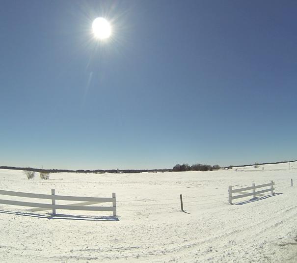
Thanks to Rob Koch for the picture below...
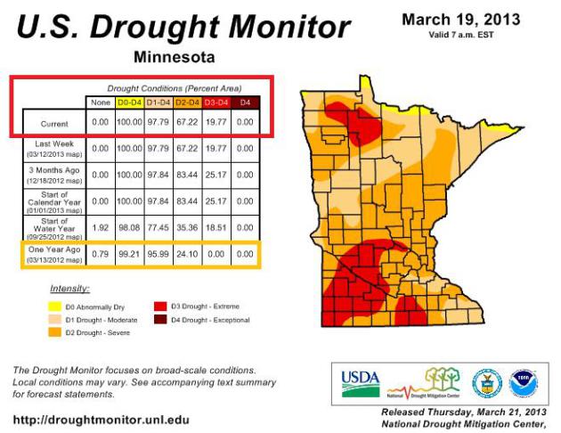
MN Drought
The latest update from the U.S. Drought Monitor had 100% of the state considered to be abnormally dry, 67% in a severe drought and 20% in an exceptional drought, worsening from last year at this time when we had 99% of the state abnormally dry and 24% in a severe drought.
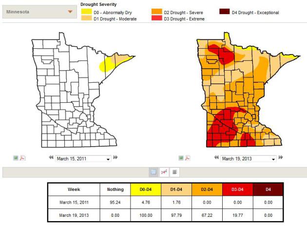
Downward Drought Sprial
Ever since the Twin Cities' 9th snowiest winter in recorded history two winters ago (86.6"), we've been in a downward drought sprial... Take a look at what it looked like in March 2011 vs. March 2013! Quite a difference isn't it? Keep in mind that last winter (2011-12) was the 4th warmest and 9th least snowy on record, which helped to perpetuate the drought the hot and dry summer of 2012... and here we are today!
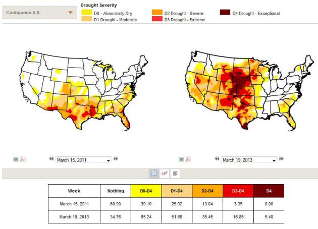
National Drought 2011 vs 2012
Look at how far the national drought has progressed since March 2011 to March 2013!
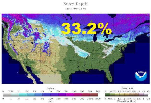
National Snow Cover
As of March 22nd, 33.2% of the nation was covered in snow, with much of that snow pack on the fairly deep side across the northern tier of the nation. That's a bit concerning as we approach the end of March and early part of April as flooding is becoming more of a concern.
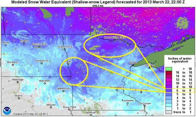
Water Locked in the Snow...
The lateset SWE analysis or "Snow Water Equivalent" shows several inches of water locked in the snow. The big concern is when/how fast that snow melts. The later it waits to warm up and if that warm-up arrives in one big heat wave, we're in trouble!
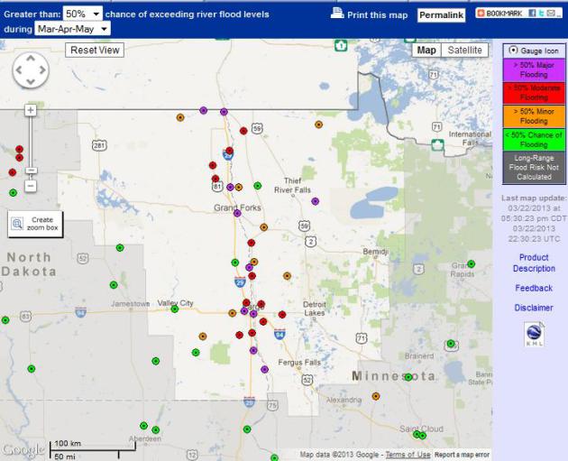
"Top 5 Flood in Fargo"
The National Weather Service stated earlier this week that Fargo, ND should expect a "Top 5 Flood" this Spring. According to NOAA, there's a greater than 95% that there will be MAJOR FLOODING in spots along the Red River in the upcoming Mar-Apr-May time period.
Here's a bookmark on Red River Flooding Updates
"Based on the above normal amount of water in the current snowpack and seasonal forecasts of continued above normal precipitation, a potential for exceeding moderate and major river flood levels exists for the Red River of the North, which forms the state line between eastern North Dakota and northwest Minnesota, and the Souris River in North Dakota for Spring 2013. These areas experienced major to record flooding two years ago in the spring of 2011."
See more from the National Hydrological Assessment HERE:
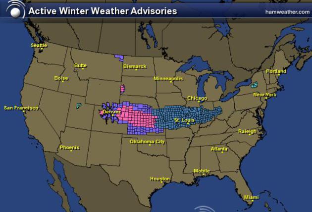
More Snow on the Way...
The National Weather Service has issued a number of winter weather headlines across the mid-section of the nation with more to come through early next week.
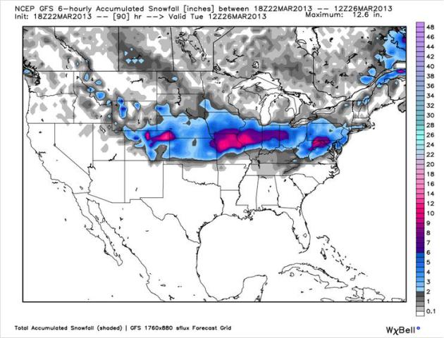
Snow Potential
Here's the GFS (American model) snowfall potential thru AM Tuesday. Note the heavy snow potential across parts of northern MO. The heavy snow band will cross into the Ohio Valley and parts of the Northeast (near D.C.) by late weekend/early next week.
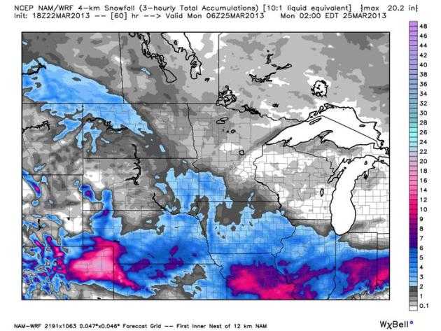
Snow Clips MN
Here's a look at the NAM/WRF model, which suggests light snow potential clipping southern MN over the weekend, the heaviest with sail well south of us into northern MO.
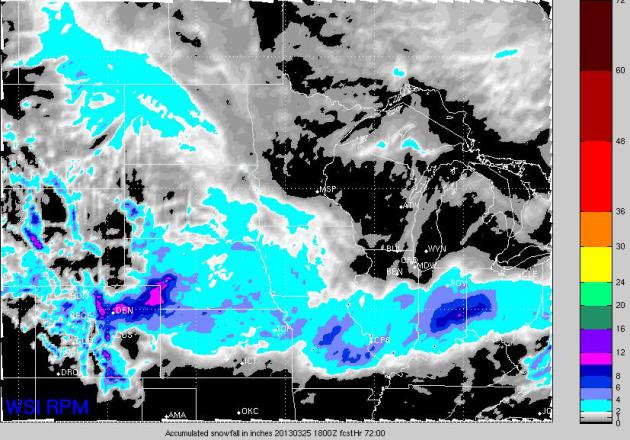
RPM Model - Snow Potential
The RPM model also clips southern MN with a little light snow thru the weekend (PM Saturday-Sunday). The heaviest stays along the Hwy I-70.
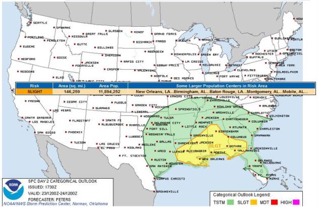
Saturday Severe Potential
The Storm Prediction Center has issued a SLIGHT RISK of severe weather for parts of the Gulf Coast region. Hail and high winds will be the primary threat with any of the stronger storms, but an isolated tornado can't be ruled out.
=================================================
Ask Paul Douglas & Todd Nelson:
Question:
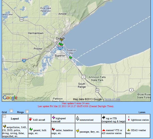
I enjoy your site and follow it every day. Yesterday 3/21/13 you showed a site for tracking lake Superior boat traffic but the link didn’t work.
Can you provide please?
Chuck Christiansen
==================
Answer:
Hey Chuck, hope this link works!
http://lakesuperiornews.com/Shipping/LakeSuperior.aspx
Have fun!!
-Todd Nelson
==========================================================================
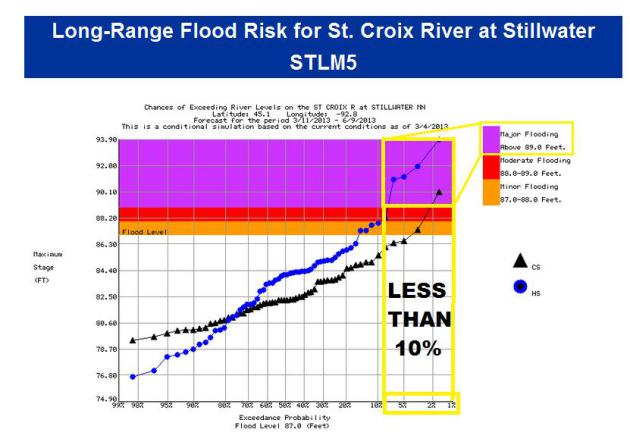
Question:
I love your little essay or post every day on the back page of the Strib regional pages
I am looking for predictions of floods and flooding this year on -the St Croix in particular. Pretty long winter,lots of snow,frozen ground and a fast melt will be tough on some of us who live in flood prone areas of the St Croix..
We were flooded in 2001, nearly flooded two years ago but a late April freeze put a stop to that. I am afraid we won't lucky this year. What do you see?
Thank you
Georgiana Anderson
===========================
Answer:
Thanks for your question Georgiana.
NOAA has an incredible wealth of information/data at the ready. It's almost hard to find it all! I was able to pull up the long range (March-April-May) river flood potential, specifically for St. Croix River at Stillwater. The forecast for current weather condtions (snowpack, frozen ground, etc.) shows that there is a LESS THAN 10% chance of MAJOR FLOODING at that site during that time frame. The big concern? Any additional heavy snow, rapid snow melt and or heavy rain as that deep snow pack is melting away. We're hoping for a nice slow melt everywhere, especially in the Red River Valley where they have greater than a 95% chance of MAJOR FLOODING.
Click any point for forecast HERE:
-Todd Nelson
===============================================================================
Question:
How do you measure snowfall depth in inches, especially with drifting? Thanks, Ed Morsman
=============================
Answer:
Hey Ed, I'm actually a part-time
weather observer at the Minneapolis/St. Paul International Airport.
I've been a part-time weather observer since the early 2000s. I must
have some sort of weather addiction that has not yet been diagnosed.
I can honestly say, that it's not only my job, but it's also my hobby
and passion!
I agree that it can be fairly difficult to get an accurate reading when there's any drifting over a certain area, but that's why it's necessary to take get an avearge. Try to find a spot where the snow looks 'uniform' and take several measurments, then average those.
I agree that it can be fairly difficult to get an accurate reading when there's any drifting over a certain area, but that's why it's necessary to take get an avearge. Try to find a spot where the snow looks 'uniform' and take several measurments, then average those.
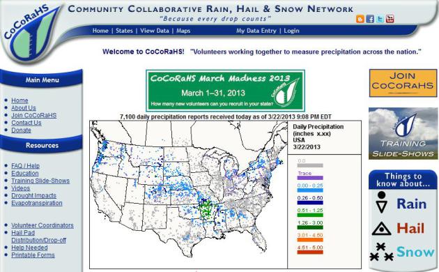
The National Weather Service is
always in need of additional snowfall reports. You can do it too, by
joining the CoCoRahs... want to join?
By the way, they're running a
March Madness campaign to see which state can recruit the most new
CocoRahs members! Let's see if MN can win!!
"MARCH MADNESS
Welcome to the CoCoRaHS March Madness Page. CoCoRaHS March Madness is our friendly recruiting contest between all 50 states to see who can recruit the most new volunteers during the 31 days of March. There is always a need for a greater number of observations, as the saying goes "the rain doesn't fall the same on all". Due to the variability of precipitation, amounts measured can be quite different only a block or two away. Help fill in the gaps by recruiting a friend or relative during our contest. The more observations, the clearer the picture, the better the understanding of where it did and did not rain."
Welcome to the CoCoRaHS March Madness Page. CoCoRaHS March Madness is our friendly recruiting contest between all 50 states to see who can recruit the most new volunteers during the 31 days of March. There is always a need for a greater number of observations, as the saying goes "the rain doesn't fall the same on all". Due to the variability of precipitation, amounts measured can be quite different only a block or two away. Help fill in the gaps by recruiting a friend or relative during our contest. The more observations, the clearer the picture, the better the understanding of where it did and did not rain."
Thanks for checking in, have a great weekend ahead.
Don't forget to follow me on Twitter @TNelsonWNTV