Real Twins Fans
In two days we'll discover who the true,
die-hard Twins fans are. They'll be the ones braving the coldest home
opener on record, in all probability.
According to Pete Boulay at the Climate Office
the previous record for coldest opener was April 14, 1962, with an air
temperature of 34F at the old Met Stadium. Monday's high will be near
31F, with a wind chill of 15-20F. Lovely.
We're creeping into spring this year; 40s feel
like a Godsend. Dr. Mark Seeley reports February-March was the coldest
such period since 2001 in the Twin Cities - and I believe him.
Persistent chill is delaying snow melt up north,
increasing the potential for flooding, especially on the Red River. The
risk has increased for Montevideo, Long Prairie, Aitkin and St. Cloud -
details on the weather blog below.
Showery rains this morning give way to partial
clearing by evening. A colder wind kicks in Easter Sunday - Monday
appears to be the coldest day in sight; a cruel April Fool's joke.
Quick moderation is likely; 50F possible later next week - more rain in the extended outlook.
NOAA is still predicting "improvement" in our
drought by June. If only spring would finally arrive, our moods would
improve as well.
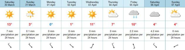
Cold Twins Home Opener. We'll see who the TRUE Twins
Fans are on Monday - who turns out to brave wind chills in the teens. I
enjoyed this post in Mark Seeley's latest
WeatherTalk Newsletter: "
According
to historical analysis by Pete Boulay of the MN State Climatology
Office it appears that the Minnesota Twins may open the season Monday
(April 1st) with the coldest temperatures ever for this occasion, highs
forecasted to be in the low-30s F. The coldest home opener in
franchise history was on April 14, 1962 when the daytime high was 34
degrees F (Twins lost to the Angels 12-5 at the old Met). The Twins are
scheduled to open against the Detroit Tigers at 3:10 pm on Monday,
April 1st at Target Field with an expected temperature of 32 degrees F,
and windchill in the high teens F to low 20s F. Long underwear under
the uniform may be the common wardrobe that day. Incidentally the
warmest ever home opener? On April 22, 1980, again at the old Met
against the Angels the temperature was 90 degrees F (Twins won 8-1).
You can read more about the weather for Twin's Home Openers at..."
http://www.climate.umn.edu/doc/journal/Twins_home_opener_weather.htm
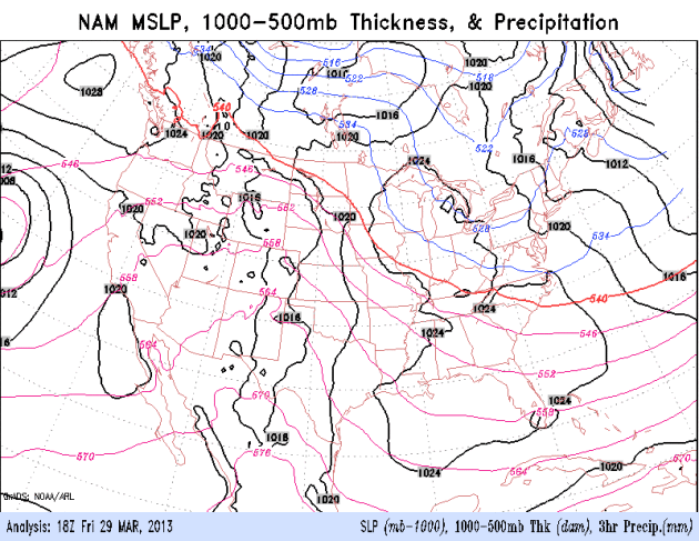
* Map above shows ECMWF predicted temperatures at 1 pm Monday.
Brief Temperature Pothole. The good news: the sun is
to high in the sky for it to stay cold for long. That said, highs
struggle to reach 32 F. Monday and Tuesday, before rebounding to near 50
next Wednesday, again Friday. A quarter inch of rain may fall this
morning, but no major storms are brewing next week, just showers and
possible T-showers the end of next week.
Mild Saturday, Then Another Reality Check. The
latest 84-hour NAM model shows more cold air hurtling south of the
border late Sunday into Tuesday. Temperatures moderate the latter half
of next week.
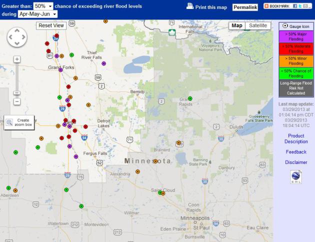
Flood Potential Grows. As much as 5-8" water in the
snowpack over much of the Red River Valley, coupled with lingering chill
(and little melting in recent weeks) has increased the potential for
major flooding, especially on the Red River from Montevideo to Fargo and
Crookston. Details from NOAA: "
Areas of concern that have an increased risk over the historical flood history include:
· Minnesota River at Montevideo (Much above normal – now an 86% chance to see minor flood stage of 14 ft.)
· Long Prairie River at Long Prairie (Above normal now has a >95% chance to see minor flood stage of 6.0 ft.)
· Mississippi River at Aitken (above normal ~ 85% chance to see minor flood stage of 12ft)
· Mississippi River at St Cloud (above normal now has a 52% chance to see minor flood stage of 9.0 ft.)
"
The threat for ice jams is increasing. This is especially of
concern for the upper Mississippi River (Anoka and upstream) and on the
Minnesota River. Information that would be very helpful to know include
location of the jam (more prone locations include river bends and
bridges), tupe of ice (solid sheets or "chunks"), length of the jam and
is water rapdily rising behind the jam."
Coldest March For The UK Since 1962. The
UK Met Office
has the details: "This March is set to be the coldest since 1962 in the
UK in the national record dating back to 1910, according to
provisional Met Office statistic. From 1 to 26 March the UK mean
temperature was 2.5 °C, which is three degrees below the long term
average. This also makes it joint 4th coldest on record in the UK.
Looking at individual countries, March 2013 is likely to be the 4th
coldest on record for England, joint third coldest for Wales, joint 8th
coldest for Scotland and 6th coldest for Northern Ireland.
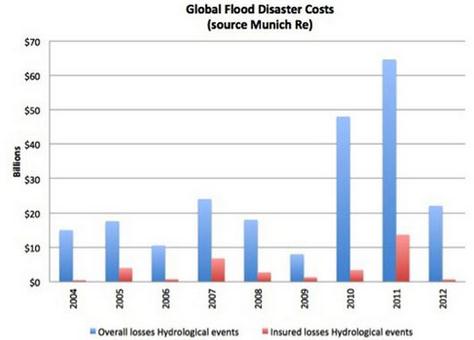
Why You Are Paying For Everyone's Flood Insurance.
Yahoo News has the story; here's an excerpt: "
There are many, many compelling and urgent reasons to take decisive action to combat climate change.
Here's one that's measurable by dollars added to our budget deficit.
Actually by tens of billions of dollars. The soaring cost of private flood insurance
is pricing so many coastal homeowners out of the market that the rest
of the American taxpayers are having to bail them out – to the tune of
$30 billion under the National Flood Insurance Program (NFIP). With over $139 billion in storm, wildfire, drought, tornado and flood damages taking nearly 1 percent of U.S. gross domestic product (GDP) in 2012, the insurance industry
is referring to last year as the second costliest year on record for
U.S. climate-related disasters. And while insurers do include $12
billion worth of flood-related damages in their estimates, they aren't
the ones getting stuck with most of the bill. It's us, the taxpayer..."
Climate Stories...
Q&A: Europe's Freezing Easter, Global Warming And Melting Arctic Ice.
The Washington Post does a good job explaining how record melting of
Arctic ice last year may be displacing unusually cold air south,
creating colder than average conditions across much of North America,
Europe and Asia. Here's an excerpt: "...
Global warming is melting
the ice cap over the Arctic Ocean. Last September, it reached its
lowest extent on record. Climate models show that the loss of sea ice —
which acts as a lid on the ocean, preventing it from giving off heat —
triggers feedback mechanisms that shake up the climate system further.
A series of studies in recent years have shown that one such effect
could be changes in atmospheric circulation, resulting in more frequent
cold snaps in Europe.
Q: How would melting Arctic ice lead to cold snaps?
A: The theory is the loss of sea ice means more heat is released
from the open ocean, warming the layer of polar air over the water.
That reduces the temperature and air pressure differentials with more
southern latitudes, increasing the likelihood of a negative state in
the atmospheric circulation..."
Worst Allergy Season Ever? Fantastic. Something to look forward to.
Live Science has the story; here's an excerpt: "
This
spring could be the most miserable one ever for those of us with
allergies, and we can blame it on climate change. People in the
Northeast, in particular, will be among the hardest hit in the
aftermath of Hurricane Sandy and this winter's record-setting blizzard,
both of which dumped massive amounts of precipitation over the
region. "[This] promises a robust allergy season,'' said Leonard
Bielory, an allergy and immunology specialist with the Rutgers Center for Environmental Prediction
in New Jersey, a state which suffered widespread destruction from
Sandy. "The first airborne tree pollen has been measured in recent
days, and while the count is still low, some allergy sufferers are
showing comparatively severe symptoms,'' he added. "I expect more tree
pollen than ever to be released this spring, and the reaction to the
early pollen to be unusually strong...''
Photo credit above: dreamstime.com.