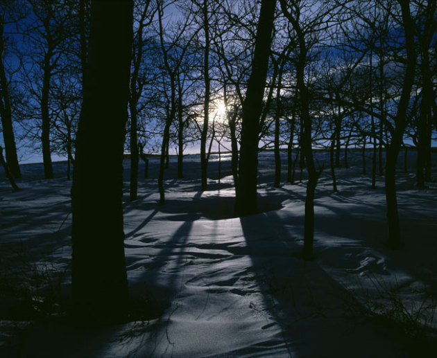
April Fool
In an effort to cut down on cold-related
injuries in the field the Twins will use a Wiffle Ball for today's
chilly game at Target Field. Bundle up - a cruel breeze will make it
feel like 15-20F by the 8th inning.
In other news NOAA will be naming tornadoes
after American Presidents in 2013. "Our goal is to make warnings more
memorable and authoritative", an unnamed official remarked. How odd.
Look at the bright side: this will probably be
the last significant blast of numbing air. Famous last words. Today will
be the most uncomfortable day; winds ease Tuesday and daytime highs
rebound to 50F the latter half of this week as The Big Melt resumes.
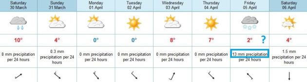
It's a volatile pattern, making the 7-Day
Outlook more tenuous than ever. I don't see any 60s, but a cold rain is
likely late Friday into Saturday, again on Monday. Remember, the larger
the north-south contrast in temperature the greater the odds of Pacific
storms strengthening east of the Rockies, pushing Gulf moisture into
Minnesota.
The latest 30-year averages show 2 inches of
slushy snow during a typical April - it usually melts within 24 hours.
By April 30 the average high is a balmy, hope-inspiring 65F.
And that's no joke.
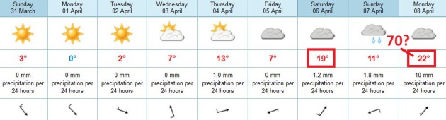
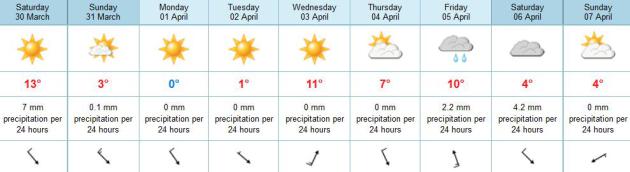
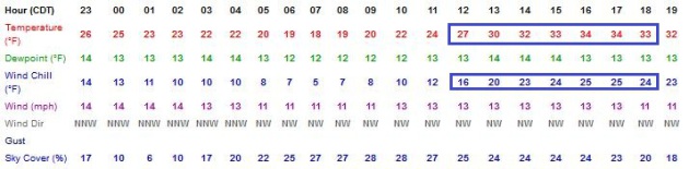
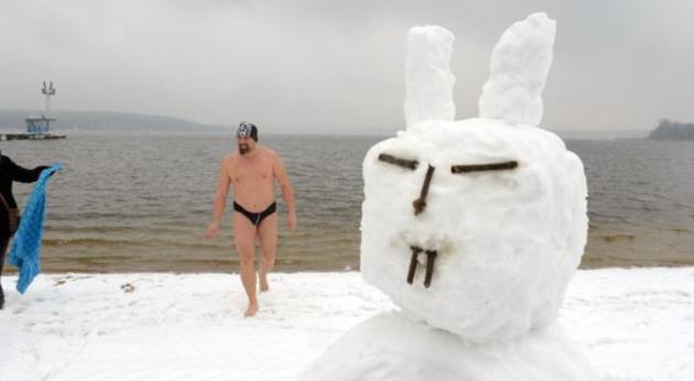
Gloves: On The Field And Off.
Heading to Target Field for the Twins Home Opener? Pack your warmest
clothes, because models show air temperatures in the upper 20s and low
30s, with a wind chill hovering from 18-25F. More like a Gophers game in
mid-December. At least the sun will be out much of the afternoon, which
should help (a little).
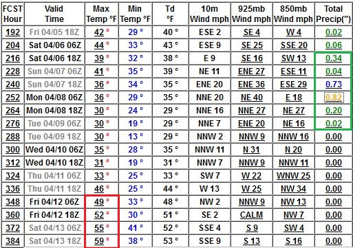
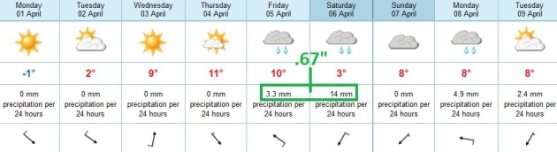
Warming Trend. Today will be as chilly as it's going
to get (hopefully until October or early November). Highs nudge 50F by
Wednesday; temperatures near or even a few degrees above normal into
next week. Right now ECMWF data suggests Saturday will be the wettest
day in sight (.67" rain predicted late Friday into Saturday).
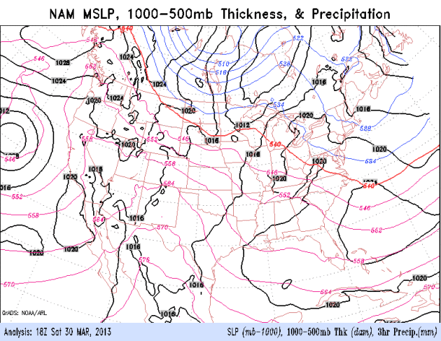
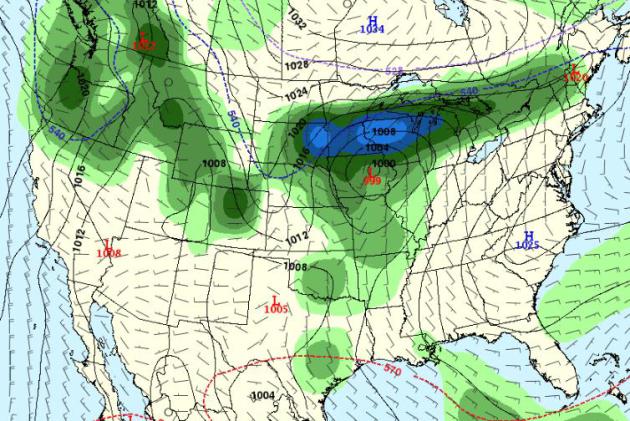
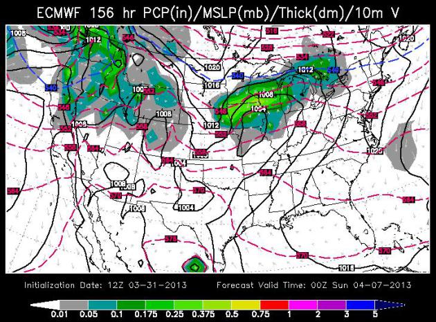
Warm Enough For Rain. ECMWF model data valid
Saturday evening shows a storm sliding just south of Minnesota, throwing
a shield of light to moderate rain across Iowa into southern Minnesota.
Right now Saturday appears to be the wetter day of the weekend.
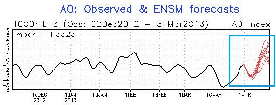
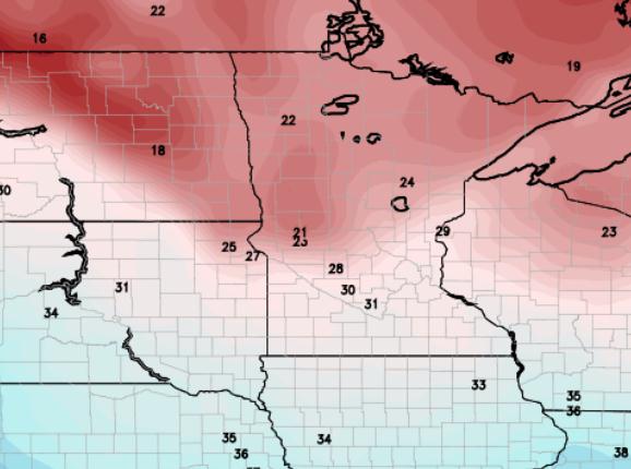
Pattern Shift? The AO (Arctic Oscillation) has been
strongly negative since mid-February, meaning light steering winds over
North America, allowing unusually cold air to plunge south into the USA.
A phase-shift to a strongly positive phase of the AO suggests stronger
west to east jet stream winds, hinting at a warming trend as winds aloft
blow from the Pacific (and hopefully the Gulf of Mexico). Graphic:
NOAA.
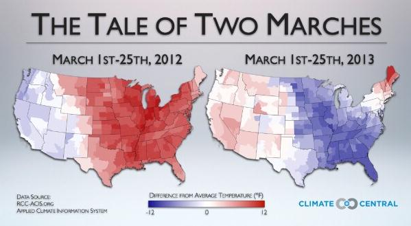
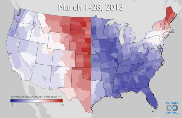
From 2012 To 2013 March Blows Hot, Then Cold.
Climate Central
has a good explanation of how the weather over the USA can be so
radically different from year to year; here's a snippet: "...Think of
the Arctic as the Northern Hemisphere’s refrigerator. The blocked
weather pattern, which some scientists think may be tied to the rapid
warming of the Arctic and the subsequent loss of sea ice cover - has
opened the refrigerator door, causing cold air to spill out of the
freezer that is the Far North and help develop winter storms in the
northern mid-latitudes. One such storm occupied much of the Northern
Atlantic on Thursday, stretching from just south of Greenland all the
way east to Ireland and Spain. The cold weather this month has been in
stark contrast to last March, when an unprecedentedly long-lasting and
intense early spring heat wave sent temperatures soaring into the 80s all the way to the U.S. border with Canada.
The interactive graphic above shows a comparison between the
temperature departures from average during March of 2013 (through March
28) and March 2012.
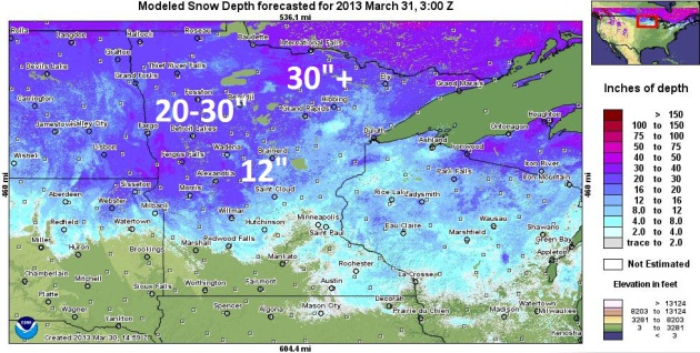
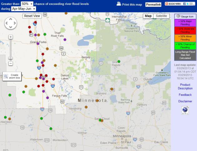
What Keeps River Forecasters Up At Night? Although
snow is going fast in and around the Twin Cities metro, there's still
closer to a foot on the ground just north/west of St. Cloud, closer to
20-30" snow from Morris and Alexandria to Detroit Lakes, Bemidji and
much of the northwestern third of Minnesota, according to NOAA
calculations.
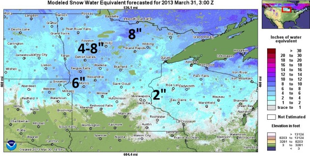
Snow Water Equivalent. What's important isn't how
many inches of snow is left up north, but the SWE, or snow water
equivalent - how much water is locked up in that snowpack. As much as
4-8" of water is in the snow west of Brainerd and Wadena. A worst case
scenario for river flooding would be a temperatures spike into the 50s
and 60s, coupled with significant rain. That scenario may be shaping up
in 6-10 days - something we'll need to keep a very close eye on.
Flood Potential Grows. As much as 5-8" water in the
snowpack over much of the Red River Valley, coupled with lingering chill
(and little melting in recent weeks) has increased the potential for
major flooding, especially on the Red River from Montevideo to Fargo and
Crookston.
Details from NOAA: "
Areas of concern that have an increased risk over the historical flood history include:
· Minnesota River at Montevideo (Much above normal – now an 86% chance to see minor flood stage of 14 ft.)
· Long Prairie River at Long Prairie (Above normal now has a >95% chance to see minor flood stage of 6.0 ft.)
· Mississippi River at Aitken (above normal ~ 85% chance to see minor flood stage of 12ft)
· Mississippi River at St Cloud (above normal now has a 52% chance to see minor flood stage of 9.0 ft.)
"
The threat for ice jams is increasing. This is especially of
concern for the upper Mississippi River (Anoka and upstream) and on the
Minnesota River. Information that would be very helpful to know include
location of the jam (more prone locations include river bends and
bridges), tupe of ice (solid sheets or "chunks"), length of the jam and
is water rapdily rising behind the jam."
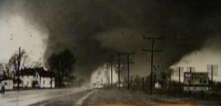
Palm Sunday: A Retrospective Of One Of Michiana's Worst Disasters.
WSBT-TV has the story (and remarkable videos). Here's an excerpt: "
It's
considered one of the worst disasters in our area's history, killing
around 50 people in Elkhart County and injuring many others. This
retrospective by WSBT-TV, which originally aired in 1995, chronicles
the events of Palm Sunday, April 11, 1965 through original broadcasts
and survivor interviews."
Hurricane Center Again Breaks Accuracy Records. NHC did a good job last year, overall. Heres' a good recap from
SunSentinel: "
Once
again, the National Hurricane Center again broke forecast track
accuracy records during the tumultuous 2012 storm season. While issuing
444 advisories for the likes of Hurricanes Isaac and Sandy, the center
set track prediction records for every forecast period except for the
longest one, which predicts what a storm will do over the next five
days. Here are the average errors:
For the 12-hour period: 28 miles, down from 32 miles last year.
For the 24-hour period: 45 miles, down from 50 miles..."
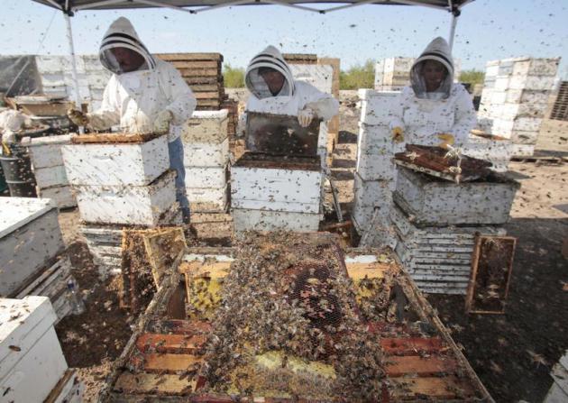
Are Agriculture's Most Popular Insecticides Killing Our Bees? NPR has the story - here's the intro: "
Environmentalists and beekeepers are calling
on the government to ban some of the country's most widely used
insect-killing chemicals. The pesticides, called neonicotinoids, became
popular among farmers during the 1990s. They're used
to coat the seeds of many agricultural crops, including the biggest
crop of all: corn. Neonics, as they're called, protect those crops from
insect pests. But they may also be killing bees. Christian Krupke,
a professor of entomology at Purdue University in Indiana, is among
the scientists whose research has alarmed beekeepers. Last month, I
caught up with Krupke at a DoubleTree Hotel in Bloomington, Ill., where
he was giving a talk to several hundred farmers and the agricultural
consultants who advise them about seeds, fertilizer and pesticides. The
meeting was organized by GrowMark, a farm supply company..."
Photo credit above: "Workers clear honey from dead beehives at a bee farm east of Merced, California." Marcio Jose Sanchez/AP.
Sugar Industry's Secret Documents Echo Tobacco Tactics. Here's a snippet of a remarkable story from Canada's
CBC Network: "...
As
Couzens sorted through the documents, the full extent of that campaign
to forge public opinion emerged. The documents describe industry lobby
efforts to sponsor scientific research, silence media reports critical
of sugar, and block dietary guidelines to limit sugar consumption. The
Sugar Association's president reported to the Board of Director's
meeting in October, 1976 that, "in confronting our critics we try never
to lose sight of the fact that no confirmed scientific evidence links
sugar to the death-dealing diseases. This crucial point is the life
blood of the association..."
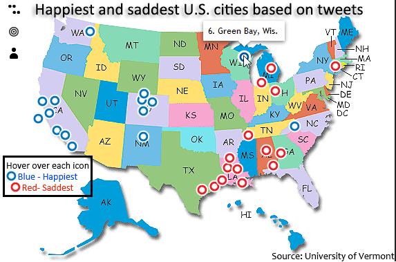
15 Happiest And Saddest U.S. Cities Based On Tweets.
Not sure if it's scientifically possible to deduce who is happy vs. sad
from tweets, but I found it vaguely interesting that the happiest
people tend to live in the western half of the USA (with the exception
of Green Bay).
ThingLink has the infographic.
Climate Stories...
Doubling Down On Our Faustian Bargain. NASA's Dr. James Hansen has the story at
Huffington Post; here's an excerpt: "...
Reduction of the net human-made climate forcing by aerosols has been described as a "Faustian bargain," because the aerosols constitute deleterious particulate air
pollution. Reduction of the net climate forcing by half will continue
only if we allow air pollution to build up to greater and greater
amounts. More likely, humanity will demand and achieve a reduction of
particulate air pollution, whereupon, because the CO2 from fossil fuel
burning remains in the surface climate system for millennia, the
"devil's payment" will be extracted from humanity via increased global
warming..."
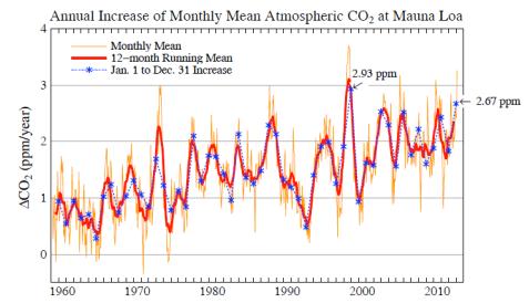
Graphic credit above: "
Annual increase of CO2 at Mauna
Loa. The 12-month running mean reduces the double noise in the 12-month
change. Blue asterisks show the end-of-year 12-month change often
reported in the media."
Scientists: Wooded Areas In The Arctic To Increase By Up To 50% Over Next Decades.
BNOnews has the article; here's an excerpt: "
New
models predict drastically greener Arctic in coming decades Boom in
trees, shrubs expected to lead to net increase in climate warming. New
research predicts that rising temperatures will lead to a massive
"greening," or increase in plant cover, in the Arctic. In a paper
published on March 31 in Nature Climate Change, scientists reveal new
models projecting that wooded areas in the Arctic could increase by as
much as 50 percent over the next few decades. The researchers also show
that this dramatic greening will accelerate climate warming at a rate
greater than previously expected. "Such widespread redistribution of
Arctic vegetation would have impacts that reverberate through the
global ecosystem," said Richard Pearson, lead author on the paper and a
research scientist at the American Museum of Natural History's Center
for Biodiversity and Conservation..."
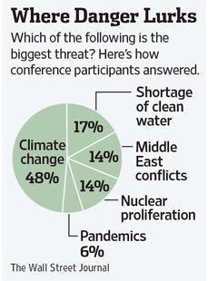
Climate Change Is The Risk That Increases All Others. Here's an excerpt of an Op-Ed from the CEO of Skoll Global Threats Fund at
The Wall Street Journal: "
Climate
change is the greatest risk we face. It's the great exacerbater. It
exacerbates the risk of pandemics. It exacerbates the risks of water.
It exacerbates the risk of conflict. Take a look at South Asia, where
China owns the ice, India owns the water and has 21 dams, and Pakistan
and Bangladesh are out of luck. Pakistan's entire food production is
dependent on two other nuclear-armed countries..."
James Inhofe "Proud" To Be A Target In Climate Change Documentary.
Huffington Post has the story; here's an excerpt: "
Sen.
James Inhofe is taking criticism of his climate change denial as a
compliment. The Oklahoma Republican is one of the central targets in the
newly released climate change documentary "Greedy Lying Bastards,"
which examines attempts by the fossil fuel industry to thwart emissions
standards and mispresent the facts in the face of changing global
climate conditions. The film airs Friday at a special screening in
Tulsa, Okla. "I was not surprised to see myself front and center on the
promotional material for this climate change movie," he told the Tulsa World, "and quite frankly, I'm proud of it." Inhofe has long called climate change a "hoax," insisting "we're in a cold spell" when it snows, despite the body of scientific evidence showing that humans contribute to global warming..." (Photo: AP).
Q&A: Europe's Freezing Easter, Global Warming And Melting Arctic Ice.
The Washington Post
does a good job explaining how record melting of Arctic ice last year
may be displacing unusually cold air south, creating colder than average
conditions across much of North America, Europe and Asia. Here's an
excerpt: "...
Global warming is melting the ice cap over the Arctic
Ocean. Last September, it reached its lowest extent on record. Climate
models show that the loss of sea ice — which acts as a lid on the
ocean, preventing it from giving off heat — triggers feedback
mechanisms that shake up the climate system further. A series of
studies in recent years have shown that one such effect could be
changes in atmospheric circulation, resulting in more frequent cold
snaps in Europe.
Q: How would melting Arctic ice lead to cold snaps?
A: The theory is the loss of sea ice means more heat is released
from the open ocean, warming the layer of polar air over the water.
That reduces the temperature and air pressure differentials with more
southern latitudes, increasing the likelihood of a negative state in
the atmospheric circulation..."


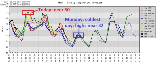
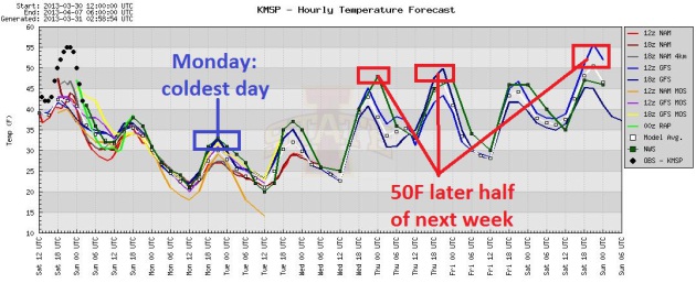 Winter Relapse.
I won't go on record saying this will be the last cold front of the
winter season (I'm not that crazy), but this may be the last time
MSP has to struggle just to reach freezing (Monday). A high sun angle
results in a rapid rebound next week; highs near 50 from Wednesday into
Friday, maybe significantly warmer by next weekend. Graphic: Iowa State.
Winter Relapse.
I won't go on record saying this will be the last cold front of the
winter season (I'm not that crazy), but this may be the last time
MSP has to struggle just to reach freezing (Monday). A high sun angle
results in a rapid rebound next week; highs near 50 from Wednesday into
Friday, maybe significantly warmer by next weekend. Graphic: Iowa State.