Bitter Memories
O.K. On a Cold Scale of 1 to 10, 1 being minor
goosebumps, 10 is Minnesota's record cold of -60 F. (Tower, on Groundhog
Day 1996) - the next 36 hours will be a 4. Really.
Some readers have shared their fondest memories
of the REAL arctic fronts that swept into town on a regular basis in the
70s. "Using a credit card to scrape the ice from the INSIDE of my
windshield." "Holding my breath, so I wouldn't feel the ice crystals up
my nose!" "Suddenly owning a Flintstone Car with tires made of
concrete!" Ah, those were the days.
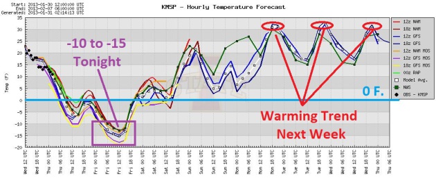
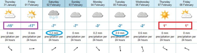
Today will be plenty cold, in fact you can count
the high on two fingers (3 if you're bad with math, like me) - a wind
chill of -20 F. If skies clear and winds ease, tonight may be the
coldest of winter; Friday morning wake-up air temperatures from -12 to
-16 F.
This will be a relatively quick, concentrated
burst of pain. Saturday looks tolerable (upper teens!) with 20s Sunday; a
thaw likely by late next week. Snow? Can I interest you in a fresh foot
of lake effect over the U.P. of Michigan?
King Boreas gets the last laugh over at the
St. Paul Winter Carnival. No risk to ice carvings in Rice Park. But the
Boat Show starts today over at the Minneapolis Convention Center.
First sign of spring?
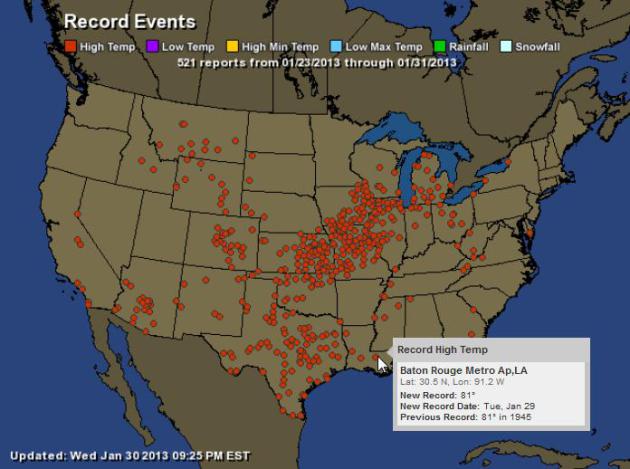
521 Record Highs: The map above shows record highs
since Wednesday of last week. It does not include additional record
highs yesterday. The warmth came tantalizingly close to Minnesota, low
to mid 60s reached Chicago Tuesday. Map:
Ham Weather.
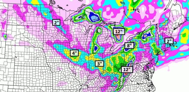
 Concentrated Burst of Subzero
.
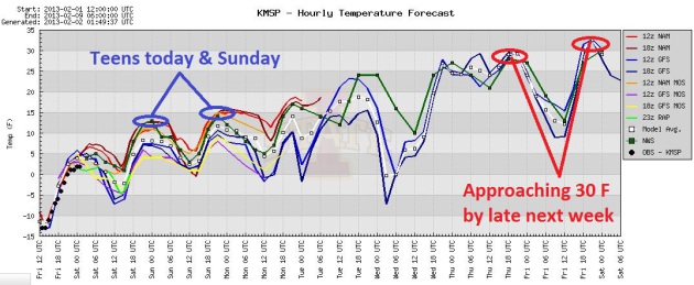
It won't stay as cold, for as long, as it did early last week. That
said, today won't be much fun, highs creeping just above zero, with a
wind chill of -20 much of the day. Tonight may be the coldest night of
winter (if we get colder than -12 F). I'm expecting -12 to -14 by Friday
morning, assuming clear skies and diminishing winds. Some recovery is
likely over the weekend; model guidance showing highs near 30 next week.
Graphic: Iowa State.
 Winter Cold, Without Much Snow
.
It's unusual to be this cold, with so little snow on the ground over
much of central and southern Minnesota. Today and tomorrow are the
coldest days in sight, the arrival of slightly milder air setting off a
coating to a half inch of snow Saturday; another clipper dropping up to
1" next Tuesday. The best chance of a thaw: the latter half of next
week, based on ECMWF guidance.
Extended Outlook: February 6-12. NOAA's experimental
NAEFS temperature trends show warmer than average conditions over much
of the USA for the second week of February as bitter air finally
retreats into northern Canada. The worst of the chill should be history
by Saturday. Spread the news.
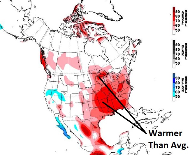
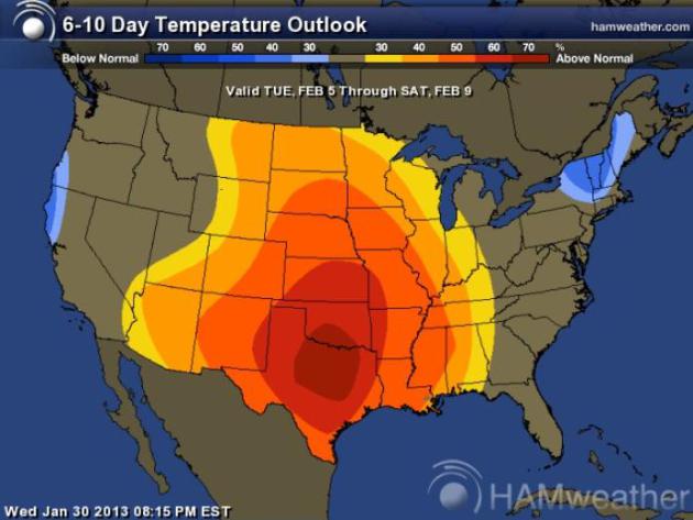
Warming Trend Next Week. The extremes in recent
weeks have been impressive, as much as 50-60 degrees in some cities. A
building ridge of high pressure coupled with a flow form the Pacific
triggers milder weather the first week of February over the central
third of the USA. Map: CPC and Ham Weather.
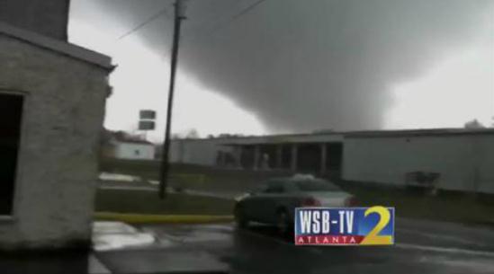
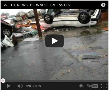
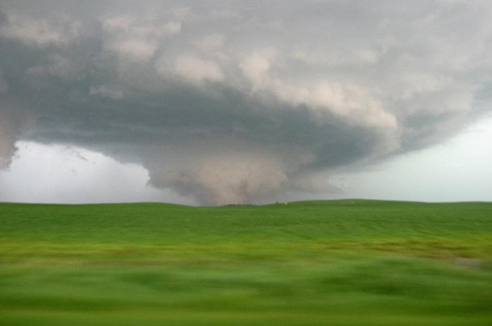
Tornado Aftermath.
Alert News
has some amazing footage of the aftermath of the Adairsville, Georgia
tornado, which claimed at least one life (in a mobile home).
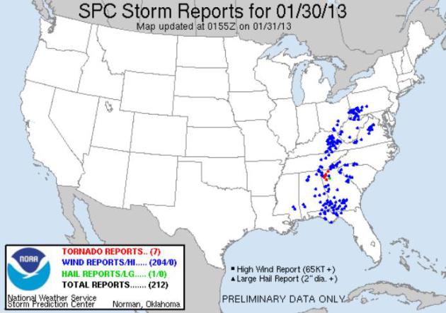
January - Or April? A surge of freakishly warm,
humid weather out ahead of a vigorous cold front, coupled with unusually
strong jet stream winds, sparked nearly 300 separate reports of wind
damage yesterday, 7 tornadoes as of 8 pm yesterday evening. Details from
SPC here.
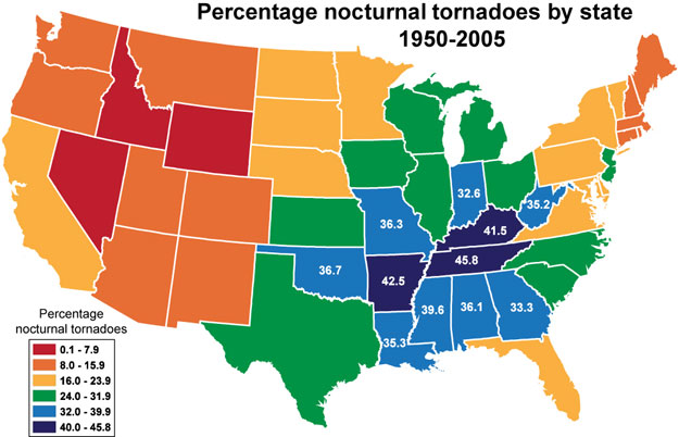
Nighttime Tornadoes Are Worst Nightmare. Here's an
overview of some new research from Northern Illinois University that
shows that tornadoes that strike between midnight and dawn are 2.5 times
more likely to result in fatalities, especially over the Mid South,
from Arkansas into Tennessee and Kentucky. The problem is
obvious: people are asleep, not monitoring media, apps or radio. How
best to get the word out of an oncoming tornado at 2 am? NOAA Weather
Radio. It may be the only thing that will set off a shrill alarm when
there's a tornado warning for your county (if it has S.A.M.E.
technology). Here's an excerpt of the article at
Northern Illinois University: "
A
new study by Northern Illinois University scientists underscores the
danger of nighttime tornadoes and suggests that warning systems that
have led to overall declines in tornado death rates might not be
adequate for overnight events, which occur most frequently in the
nation’s mid-South region. Over the past century, the tornado death rate
has declined, in large part because of sophisticated forecasting
technology and warning systems. But the researchers found that the
nighttime tornado death rate over the past century has not shared the
same pace of decline as the rate for daytime tornadoes. “The proportion
of nocturnal fatalities and killer tornado events has increased during
the last half century,” said lead author Walker Ashley, an NIU
meteorologist and professor of geography. “Unfortunately, this
nocturnal fatality rate appears to be a major factor for the stalled
decline in national tornado-fatality tallies during the past few
decades....”
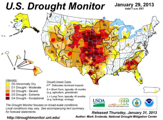
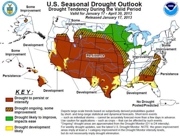
The Silver Lining In Drought: 5 Upsides To Rain-Free Weather.
O.K. I'm a glass-half-full guy, but I'm not sure this one passes the
smell test. Try explaining this to a farmer in Worthington or someone
with lakeshore (in theory) on White Bear Lake, or towns in southwestern
Minnesota where aquifers continue to recede, threatening agriculture and
drinking water. But in the spirit of full disclosure here's an excerpt
from a story at
NPR: "
Drought
is mostly seen as a bad thing — and for good reason. It dries up
crops, destroys landscaping and stops ships from moving. But even the
lack of rain clouds has a bright side...Another upside of the drought?
Fewer pests. And not just those plaguing grapes, but fewer bugs that,
well, bug humans. Mike McClain at Metropolitan Mosquito Control
District in the Twin Cities says the types of mosquitoes that drive
people crazy tend to multiply after it rains. "And when you have real
dry conditions that we did the last half of 2012, the actual number of
complaints about mosquitoes and the number biting people tends to go
way down," he says. "And that's a good thing. People are a little less
irritated by mosquitoes during drought..."
* photo above courtesy of Timothy Butz in Ellicott City, Maryland, where Tuesday's high was a balmy 64 F.
66 F. record high in Buffalo yesterday. Old record: 56 F.
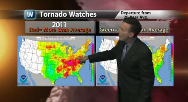
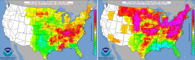
Are Tornado Alleys A Myth? It's all how you look at the data, right? Here's an excerpt of a fascinating perspective from
Discovery.com: "...
As
she wrote in her AMS meeting poster, Tornado Alley and Dixie Alley are
concepts coined by members of the meteorological community,
specifically, Tornado Alley by Fawbush & Miller in 1952, and then
Dixie Alley by Dr. Allen Pearson in 1971. “But no universal definition
of either concept exists; they shift, expand, and shrink with different
publications, authors, and purposes. They are sociopolitical rather
than scientific concepts,” Henderson explained (you can see her poster here).
The thing about the original Tornado Alley, she said, is that once it
was established, it became the scientific standard against which other
alleys were defined. The concept of a tornado-prone “alley” is a
natural outgrowth of 20th century meteorological history. Tornado alleys
are terms that have become “scientized,” she told me. “Scientization
transforms sociopolitical concepts, ideas, and other phenomena into
metrics that can be standardized and measured...” (photo: meteorologist Aaron Shaffer at WeatherNation TV).
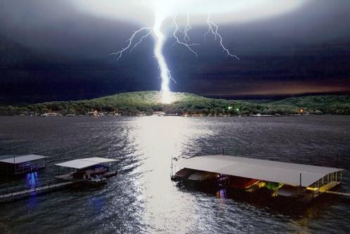
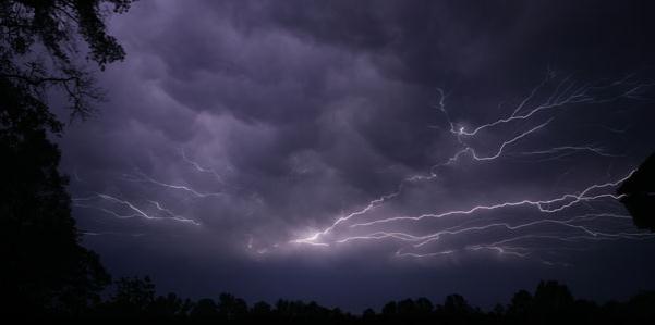
Study Links Headaches And Migraines To Weather. Lightning as a possible trigger for serious headaches? Here's a clip from
wkms.org: "
If
you've ever blamed the weather for a splitting headache, you might be
right. A new University of Cincinnati study finds that lightning may
affect the onset of headache and migraines. "What we found was that on
days with lightning around the patients' homes there was approximately
a 30-percent increase in headache activity, or headache occurrence,
and also a 30-percent increase in migraine," said fourth-year medical
student Geoff Martin, one of the researchers. The study looked at
chronic headache sufferers. There are a number of ways lightning might
be a trigger..." (Lightning photo: AP)
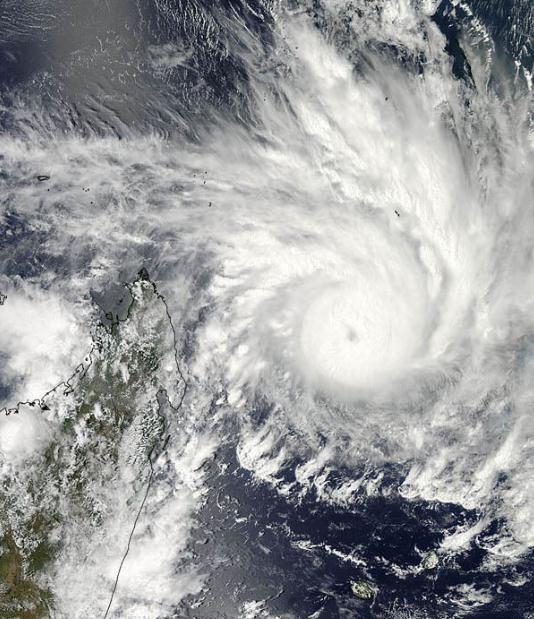
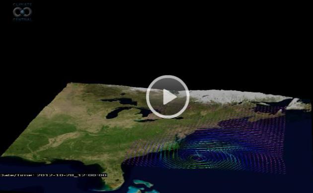
Research Spawns Stunning Hurricane Sandy Animations. Here are a few clips worth watching, courtesy of meteorologist Andrew Freedman at
Climate Central: "...
In
Sandy's wake, researchers have tried to gain a better understanding of
the characteristics of this fascinating storm, and their work has
already resulted in some interesting insights. Mel Shapiro, an
atmospheric scientist who studies how tropical storms and hurricanes
transition into powerful extratropical storm systems, recently produced
a series of astonishing animated visualizations showing the inner
workings of Sandy as the storm moved up the Eastern Seaboard and
eventually made landfall on the evening of Oct. 29. These visualizations
were produced with an ultra-high resolution computer model run at the National Center for Atmospheric Research in Boulder, Colo. Known as the ARW-WRF model, it used data from an operational computer model that the National Weather Service used to forecast the storm..."
Graphic credit above: "
The animation above shows modeled
particle trajectories that demonstrate how the low level air comes into
Hurricane Sandy and then ascends to the outflow jet at the top of the
troposphere. The outflow jet can be seen in red colors moving away from
the storm, toward the Midwest. Particle trajectories help show how the
air was flowing throughout the storm. This was done by simulating the
movement of particles inserted into a modeled storm environment."
Credit: Science by Mel Shapiro and Thomas Galarneau. Visualization by
Alan Norton, NCAR Computational and Information Systems Laboratory,
using
VAPOR visualization software.
Twice As Many Structures In FEMA's Redrawn Flood Zone.
Many homeowners living near the ocean will be forced to raise their
homes by several feet, or risk not being able to qualify for any
insurance.
The New York Times
has the story; here's an excerpt: "New federal flood maps released on
Monday revealed the grim news that many New Yorkers were girding for
after
Hurricane Sandy
sloshed away: More areas farther inland are expected to flood. Tidal
surges will be more ferocious. And 35,000 more homes and businesses will
be located in flood zones, which will almost certainly nudge up
insurance rates and determine how some structures are rebuilt. (Photo
above: Gizmodo).
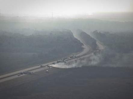
"Superfog" Not To Be Taken Lightly, Expert Says. Here's an excerpt of an interesting article at
gainesville.com that caught my eye: "
The
monster that formed over Paynes Prairie on Jan. 29, 2012, and led to
what is believed to be the deadliest set of accidents in Florida
history wasn’t merely fog or smoke or a combination of the two. It was a
unique phenomenon that can arise when the conditions are ripe, and it
could kill again. Meteorologist Gary Achtemeier with the U.S. Forest
Service knows it well. He had named it “superfog” and warns it is not
to be taken lightly. “There is only one course of action for a motorist
encountering superfog, and it is not to drive. I liken it to a bridge
collapse,” Achtemeier said. “It has to be stressed that it is a unique
phenomenon and is extremely dangerous...”
Photo credit above: "
Aerial view of Interstate 75 in
Gainesville, Fla. where according to Florida Highway Patrol at least 9
people have died as a result of multiple crashes Sunday January 29,
2012 involving 4 commercial vehicles and at least 10 passenger
vehicles. The majority of the accidents happened in an area adjacent to
where a brush fire was burning and producing heavy smoke." Rob C. Witzel/Staff photographer
Research: Discovery Of Upper Atmosphere Bacteria That Affect Weather. Here's an excerpt from
examiner.com: "...
The
finding is of interest to atmospheric scientists, because the
microorganisms could play a role in forming ice that may impact weather
and climate. Long-distance transport of the bacteria could also be of
interest for disease transmission models. The microorganisms were found
to be the appropriate size to facilitate the formation of water
droplets and ice in the regions where they were discovered. When the
air masses studied originated over the ocean, the sampling found mostly
marine bacteria. Air masses that originated over land had mostly
terrestrial bacteria. The researchers also saw strong evidence that the
hurricanes had a significant impact on the distribution and dynamics
of microorganism populations..."
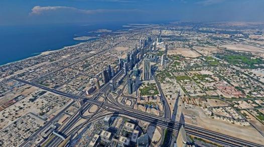
Breathtaking 360-Degree Panorama Photo Taken Atop The World's Tallest Building. Isn't this where they filmed the Tom Cruise movie? Here's an excerpt from a story at
gizmag.com: "
Until the Sky City One tower is completed in China, the Burj Khalifa
in Dubai can lay claim to being the tallest building in the world.
Standing at a whopping 828 meters (2,717 ft), it's a must-visit
destination for those traveling to the UAE. But now anyone can enjoy the
building's stunning views from the comfort of their own home thanks to
a photographer who recently composed a stunning 360-degree panorama
image taken from on top of the Burj Khalifa...."
Popularity Of New Weather-Reporting App Stuns Officials. Have you downloaded "
mPing" yet? Talk about crowd-sourcing weather; this app takes weather observations to the next level.
Interactive Intelligence has the story; here's an excerpt: "...
Already,
the National Severe Storms Laboratory has received 22,000 reports in
the first month the Precipitation Identification Near the Ground -- or
PING -- app has been in use. That's five times the number of
observations gathered by telephone over the past six years, Elmore said.
And NOAA hasn't even begun promoting PING's existence. "It's
unprecedented," Elmore said. "We have more than we ever thought we
would" in such a short time. It's all due to social media, he said.
Folks are hearing about the apps on sites such as Facebook and signing
up for it..."
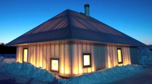
Experimental Cold Climate House Built In Japan.
Wonder if this would work in Minnesota? Here's a snippet from one of my
favorite sources for cutting-edge tech and sustainabiility news:
gizmag.com: "
Japanese
architectural firm Kengo Kuma & Associates recently demonstrated
its ethos of design inspired by light and nature with an experimental
house in Hokkaido called "Même." The structure is designed for cold
climates and whilst based upon the local Ainu people's “Chise” (House
of the Earth), it uses modern materials for an insulated double skin
membrane that promotes convection and maintains a comfortable internal
environment due to heat circulation from its continually lit fire...."
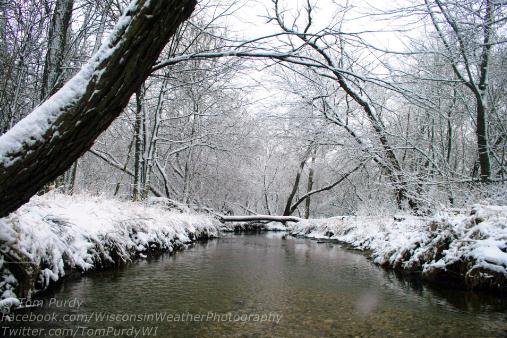
* photo above snapped in southern Wisconsin, courtesy of Tom Purdy and WeatherNation TV.
Climate Stories...
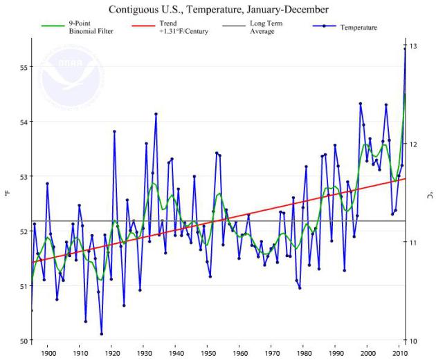
Data Bank:
U.S. Temperature Trends Since 1900. Data courtesy of
NOAA NCDC.
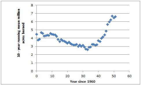
Millions of Acres Burned Since 1960 (USA). Data courtesy of
The National Interagency Fire Center.
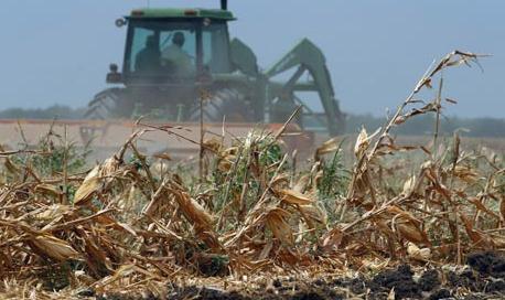
In Energy Taxes, Tools To Help Tackle Climate Change.
There's growing concern among farmers about crop insurance, how a spate
of recent disasters (Sandy comes to mind) and the federal deficit may
put even more pressure on farmers grappling with a persistent drought
over the nation's midsection. Here's an except of a
New York Times story that caught my eye: "...
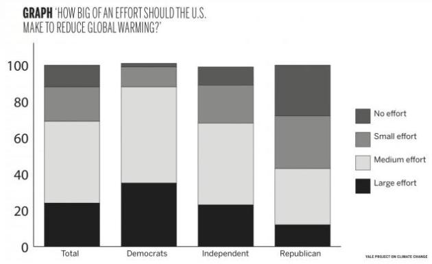
The erratic weather across the country in the last couple of years seems to be softening Americans’ skepticism about global warming. Most New Yorkers say they believe big storms like Sandy and Irene
were the result of a warming climate. Whether climate change is
directly responsible or not, the odd weather patterns have underscored
the risk that it poses to all of us. What’s yet to be seen is whether
this growing awareness of the risks will translate into sufficient
political support to address climate change, especially after we figure
out the costs we will have to bear to do so. In his inaugural address,
President Obama wove Hurricane Sandy and last year’s drought into a stirring plea to address climate change. “The failure to do so would betray our children and future generations,” the president said..." (Photo: Star Tribune).
Climate Hawk: GOP Will "Pay In The Future" For Ignoring Climate Change.
Yes, this is what I'm trying to explain to my friends on the right side
of the political aisle. A few Republicans are paying attention; they
seem to realize that this is a big deal, especially among younger
voters. Here's an excerpt from
Buzzfeed Politics: "
U.S.
Senator Sheldon Whitehouse, one of Congress' few outspoken
environmental advocates, is making a new argument for legislative action
on climate change: Lawmakers who oppose future measures to reverse
global warming, Whitehouse argues, will pay a price — in votes.
Whitehouse, who last Thursday announced the formation of a bicameral task force
to address the issue, compared climate change to social issues like
gay rights and immigration reform that Democrats claim are moving to
the center. "I'm hoping we can convince Republicans that this is a big
generational issue and, like being on the wrong side of immigration and
gay rights, there will be a huge political price to pay in the future
for being on the wrong side of climate change," said Whitehouse, the
Democratic junior Senator from Rhode Island, in an interview with
BuzzFeed..."
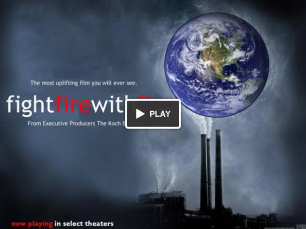
Fight Fire With Fire. Here's an overview of a
Kickstarter project
unlike anything you've ever seen: "Global warming might be real. The
problem is that this unfortunate phenomenon hurts the pocket books of
some really great Americans, like Charles and David Koch. We are two
filmmakers who want to tell the other side of the story. If we can get
enough funds together, we'll be able to make a documentary that
discredits the current theory of Global Warming so that Charles and
David can quit worrying about the earth and get back to their favorite
pastime, making money...."
Groundwater Depletion Linked To Climate Change. We
assume that when we drill a well, we'll eventually find (drinkable)
ground water. But aquifer depletion is a real concern, especially over
southwestern Minnesota. Here's a clip from a must-read article at
ScienceDaily:..."
Over-pumping
of groundwater for irrigation is mining dry the world's ancient
Pleistocene-age, ice-sheet-fed aquifers and, ironically, at the same
time increasing sea-level rise, which we haven't factored into current
estimations of the rise," says Allen. "Groundwater pumping reduces the
amount of stored water deep underground and redirects it to the more
active hydrologic system at the land-surface. There, it evaporates into
the atmosphere, and ultimately falls as precipitation into the ocean."
Current research estimates oceans will rise by about a metre globally
by the end of the century due to climate change. But that estimation
doesn't factor in another half-a-centimetre-a-year rise, says this
study, expected due to groundwater recycling back into the ocean
globally..."
Photo credit above: "
SFU earth scientist Diana Allen has co-authored a major study linking groundwater depletion to climate change." (Credit: Image courtesy of Simon Fraser University).
Whispers From The Ghosting Trees. This is a very
long (and rather haunting) explanation of why so many trees are sick and
dying worldwide. Elevated levels of ozone may be the problem. An
excerpt of this worthy read courtesy of
ScienceBlogs: "...
Is
it merely a colossal coincidence that all over the world, within the
past few decades and at a hugely accelerating rate, trees are dying? If
it’s not a coincidence, what is the underlying factor? Fair warning –
this post will be a long explanation as to how there is an underlying
factor, and why it is pollution. One of the strongest and most
persuasive evidence for me has been the visible damage to foliage and
needles that became virtually universal several years ago. Serious,
terminal damage can occur in roots before any of the classic symptoms
appear on leaves…so the fact that by the end of the summer growing
season, it is just about impossible to find a single leaf on a tree,
bush, garden produce or ornamental flowering plant that ISN’T visibly
injured indicates the extent to which the problem has intensified. Just
about any link to my blog will include photos of typical leaf damage...."
Colorado: Are January Red Flag Fire Warnings In The Mountains Part Of A New Climate Reality? Here's an excerpt from
The Summit County Citizens Voice: "
January
fire warnings, nearly unprecedented 30 years ago, have become more
common the last decade. Illustrating the persistence of extraordinary
drought conditions in parts of Colorado, the National Weather Service
issued a Red Flag fire warning
for the Rocky Mountain foothills west of Denver north to the Wyoming
border and encompassing areas that were scorched by last summer’s High
Park Fire. Boulder-based National Weather Service forecaster Mike Baker
said the agency decided to post the warning after three wildfires were
reported Wednesday (Jan. 24) within the span of an hour. All three
fires were above 8.500 feet elevation on the east slope of the
mountains along the Front Range, Baker said..."
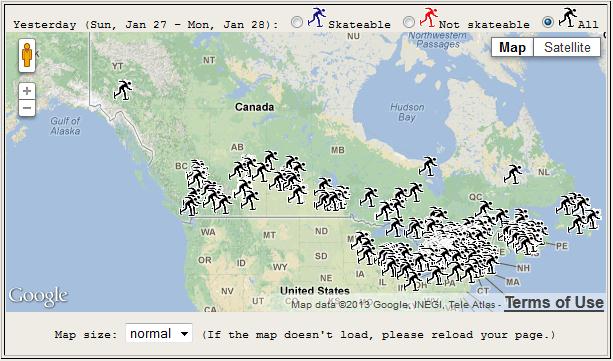
Skating Rinks Monitor Climate Change. A grass-roots,
citizen's crowd-sourced effort to track the impact of a warming climate
across Canada, by monitoring ice skating conditions. Here's more from
discovery.com: "
In
the latest citizen science venture, backyard ice skaters are
monitoring climate change in Canada and the northern United States.
After Canadian scientists predicted that global warming will eventually be the demise of backyard skating rinks, a group of geographers at Wilfrid Laurier University in Waterloo created RinkWatch. In just 20 days, 630 volunteers signed up to keep tabs on the condition of their home rinks..."
Obama Talks Climate Change. California Is Acting On It. Here's a clip from a story at
Time Magazine: "
It’s not the happiest time to be an environmentalist. Climate change hit home last year with brutal force: 2012’s historic drought
singed much of the Midwest, turning farms to dust and withering the
corn crop. Other parts of the U.S. suffered through storms like Sandy
and massive wildfires. Average annual temperatures in the continental
U.S. beat the previous recorded high by a full 1°F (1.8°C). And the
future is uglier still: over the weekend, the British economist Nicholas
Stern warned that climate change
could be even worse than he predicted in his sobering 2006 report on
the financial impact of warming, while on Jan. 28 the National Oceanic
and Atmospheric Administration (NOAA) released a draft report outlining the serious threat that sea-level rise poses to the coastal U.S..."
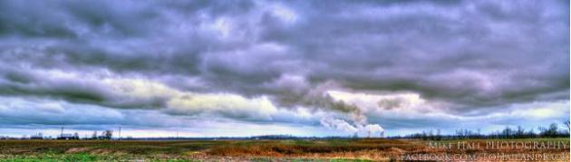
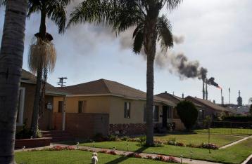
Photo credit above: Jonathan Alcom - Bloomberg. "A
row of homes on a residential street stands as the ConocoPhillips
refinery performed a non-emergency burn-off in the Wilmington district
of Los Angeles on Sept. 15, 2012."


