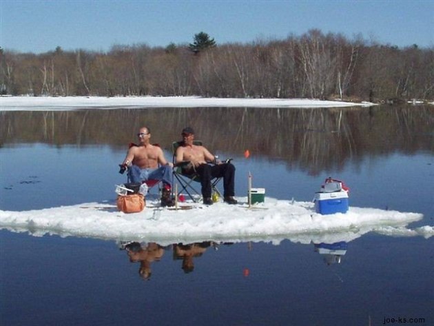
9th warmest December on record for the Twin Cities. Based on the first 28 days of this month, and the forecast through Saturday, there's a good chance this will be the 9th warmest Christmas since 1873. Source: MN State Climate Office.
2002. Last year we went through the month of December with no subzero temperatures.
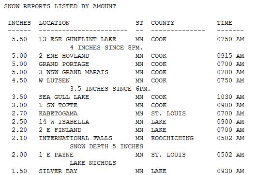
There have been 8 Decembers in the last 120 years where the mercury stayed above 0 for the entire month of December. Details below.
"
Winter is nature's way of saying, "up yours." - Robert Byrne
“
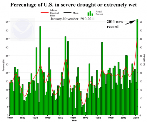
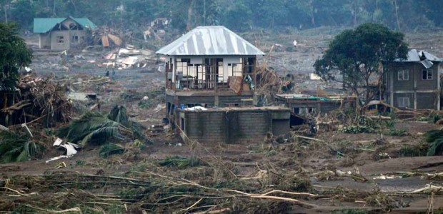
We’ve seen historic events of nearly every weather category," says Vaccaro. "So in terms of snow storms, and hurricanes and floods and droughts, all of these events this year ranked in the top three or even the highest ever recorded.” The extreme weather affected millions of people, claimed 1,000 lives, resulted in 8,000 injuries and totaled more than $52 billion in economic losses. The most costly, according to David Brown, of the National Oceanic and Atmospheric Administration, was the year-long drought that continues to grip southern plains states." - from a Voice of America story below.
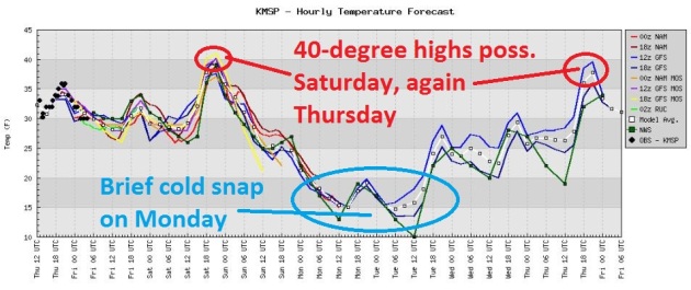
 Breaking News: Accumulating Snow?
 No, it won't be a major, knock-down, drag-out snowstorm, but a clipper-like system may trigger a period of rain changing to snow Saturday night, conveniently timed for New Year's Eve festivities. It's still early to be throwing inch-amounts around, but
I could see a couple inches of slushy snow after midnight Saturday night. Roads should be mainly wet getting to New Year's parties Saturday evening, but they may be snow-covered and icy for the trip home after midnight.
Warm Second Half Of The Year In The Twin Cities. Here's a
press release I received from Pete Boulay at the MN State Climate Office yesterday: "
It's been a warm second half of 2011 in the Twin Cities with a preliminary average temperature of 56.3 degrees. This is 4.8 degrees above the 1981-2010 average of 51.5 degrees. The second half of 2011 was so warm in fact that July to December will finish as the second warmest second half of the year on record for the Twin Cities going back to 1873. The only July-December period that was warmer is 1931 with an average of 56.8 degrees.
The last three months from October to December in the Twin Cities will finish the 3rd warmest on record back to 1873 with a preliminary average of 40.5 degrees, falling just behind 2001 with 40.8 degrees. 1931 claims the most mild spot with 41.6 degrees."
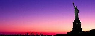
* Photo above courtesy of David Joles at the Star Tribune.
No Subzero Temperatures In December? Not As Unusual As You Might Think. We've had no nights below zero this month, which is unusual, but hardly unprecedented. Consulting meteorologist Dean DeHarpporte in Eden Prairie dropped me a line last night with some timely information. Thanks Dean!
"
I was surprised to find so many zero-less Decembers. It turns out that there have been 8 Decembers in the past 120 years that stayed above zero for the whole month:"
1913 1918 1952 1954 1959 1974 2001 2002 2011
"In 1952 and 1959, it went below zero in November, so there have been only 6 years, up to now, when zero had not been reached before January. And by this measure, our Decembers this past decade havent been any less severe in the 2000's than they were in the 1950s. However, in the 50's we averaged 6.2 subzero December days and in the 2000s we averaged only 5.2."
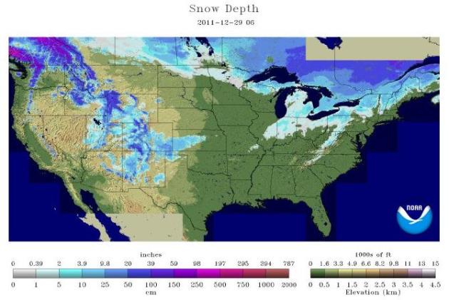
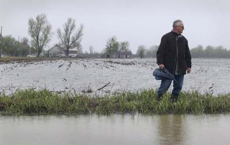
Lack Of Snow Starting To Impact Tourism Over Northern Wisconsin. The
Pierce County Herald has the story: "
EAGLE RIVER - It's called northern Wisconsin's most valuable asset, and it's in short supply right now. A lack of snow is keeping many folks away from places where they'd normally be snowmobiling, snow-shoeing, or cross-country skiing. According to the National Weather Service, the only place in the north with a decent snow-cover is Winchester in Vilas County, with eight inches on the ground. Other places have three-inches or less. And with rising temperatures later in the week, even that snow cover could be in jeopardy. Kathy Rasmussen, whose family owns a resort near Cable, tells the Eau Claire Leader-Telegram that the lack of snow is quote, "like a farmer if they don't have rain." Lisa Marshall of the state Tourism Department says it will be a while before officials know how the weather affects businesses. She says it will certainly have an impact on smaller places where the motels rely on snowmobilers."
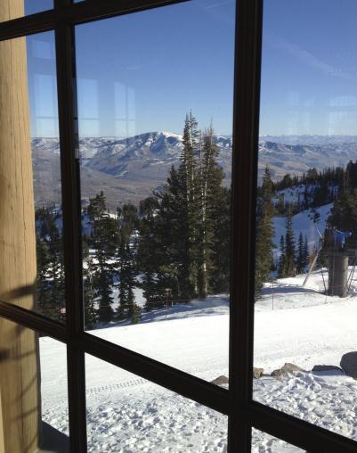
Misery Loves Company. Even the mountains of Utah are suffering from a lack of snow; snowfall about 60% of average as of yesterday. More details: "
Snowbasin Resort, seen here in a photo taken Sunday, Dec. 25, 2011, had good trail coverage on Christmas Day thanks to its extensive snowmaking systems. But the surrounding hills are brown, not white as most storms have missed Utah this winter because of Western weather patterns. A year ago snow was falling in Utah at about twice the average rate. This season the state's snowpack is just about 60 percent of average. (AP Photo/Lynn DeBruin)"
Additional Daylight Since December 22. Yes, the days are getting longer. A little longer - if you like sunshine (and warmth) things are moving in the right direction, right?
1:42 minutes added in the Twin Cities.
1:29 minutes added in Chicago.
1:24 minutes added in New York City.
:55 minutes added in Houston.
1:06 minutes added in Los Angeles.
7:22 minutes added in Fairbanks, Alaska.
"
Whatever you are be a good one." - Abraham Lincoln.
Tuesday Rainfall Records:
2.05" Meridian, MS. Old record: 1.74" in 1973.
2.20" Cape Hatteras, NC. Old record: 1.11" in 1991.
1.21" Newark, NJ. Old record: .73" in 1944.
1.17" Laguardia, NY. Old record: .81" in 1964.
1.10" Columbus, OH. Old record: .99" in 1958.
73.28" precipitation at Lancaster, PA. That's 32" more than average. Credit: Volker Kruhoeffer.
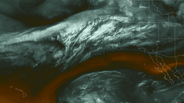
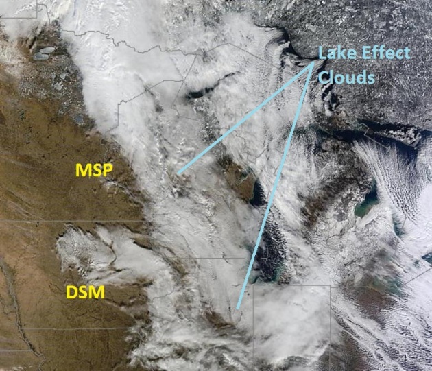
A Lighter Shade of Brown. I can't believe it's December 29. Based on NASA's "
MODIS" satellite image above the map looks like something out of late March or early April. The swirls of white from Wisconsin into the Ohio Valley are clouds, lake-effect plumes of cloud cover and snow flurries/snow showers forming downwind of the Great Lakes.
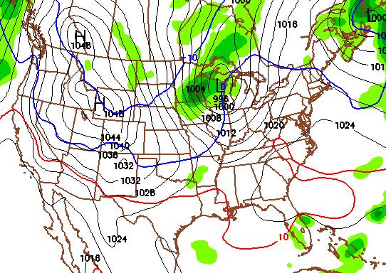
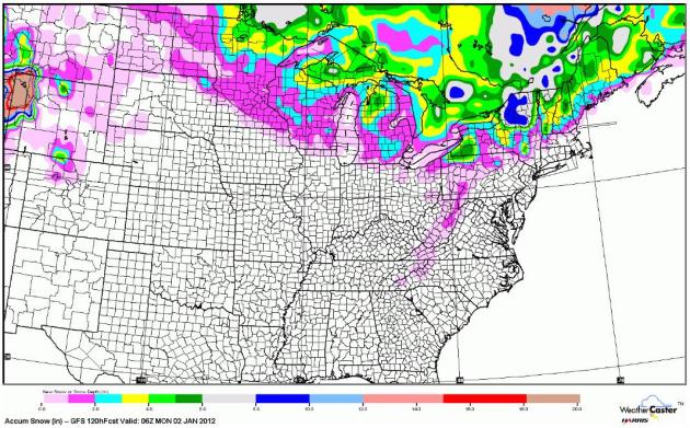
Who Will See A "White New Year's Day?" The latest GFS model shows accumulating snow from far northern Minnesota and Wisconsin into the Great Lakes (spiked by lake effect), with a series of clippers dumping significant snow on upstate New York and northern New England. Map courtesy of NOAA and WeatherCaster.
Potentially Plowable Up North. Although any precipitation in the immediate metro area will fall into the nuisance range, a few inches of snow may fall from a series of Alberta Clippers up north. As much as 2-4" of snow may fall from International Falls and Hibbing into Duluth by Saturday night.
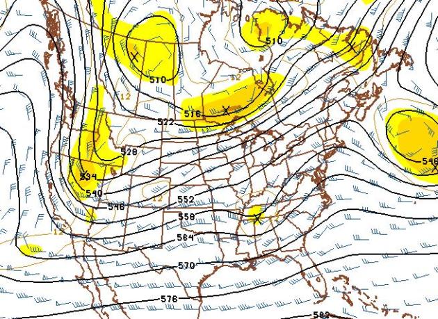 Maps Looking (A Little) Snowier By Mid January
. The GFS 500mb wind forecast for January 13 shows the westerlies finally buckling into a trough of low pressure out west - enough cold air potentially in place for a snow event close to home by Jan. 14, give or take. It's a long way off, but I'm finally detecting some signals that might point to accumulating snow for the Upper Midwest by mid January. It's still more than 2 weeks away - no guarantees, but that dust-covered snowblower may finally see some action within 2-3 weeks.
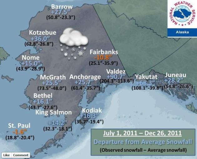
Alaska Is Having A Real Winter. It's a rough rule of thumb, and doesn't work all the time, but when Alaska is bitterly cold Minnesota (and much of the Lower 48) tends to be warmer than average - and vice versa: a mild Alaska usually means we're suffering through bitter cold. Here's a
Facebook post from the National Weather Service: "
So far, this has been a fall/winter of above normal snowfall for many locations across Alaska. How has your location fared? Anchorage has already received over 2 feet more snow than usual. Yakutat is almost 6 feet above normal, and Valdez is 7.5 FEET above normal. In contrast, Fairbanks is almost a foot below normal for this point of the season. There are still several more months of winter to come!"
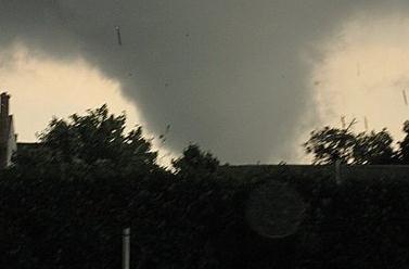
 U.S. Sets Extreme Weather Records In 2011
. Those alarmists over at
Voice of America have the story:
"That tornado was among 1,600 that crisscrossed the nation in 2011. Twelve weather-related disasters accounted for $1 billion or more each in economic losses, a new record, according to Chris Vaccaro, spokesman for the National Weather Service.“We’ve seen historic events of nearly every weather category," says Vaccaro. "So in terms of snow storms, and hurricanes and floods and droughts, all of these events this year ranked in the top three or even the highest ever recorded.” The extreme weather affected millions of people, claimed 1,000 lives, resulted in 8,000 injuries and totaled more than $52 billion in economic losses. The most costly, according to David Brown, of the National Oceanic and Atmospheric Administration, was the year-long drought that continues to grip southern plains states." Photo above courtesy of the AP.
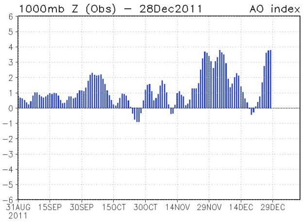
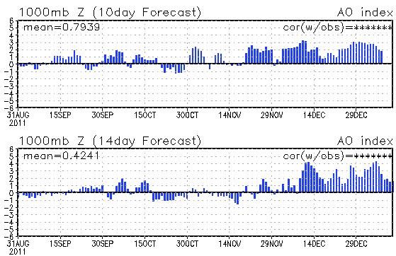
Fun With The "Arctic Oscillation" (AO). Meteorologists look at various indexes that quantify blocking patterns in the atmosphere; the tendency for weather patterns to get stuck in a persistent rut. Remember, the more positive the
AO index, the stronger the westerlies howing across North America, the less chance bitter, arctic air has to penetrate southward into the Lower 48 States. The AO index has been strongly positive for much of autumn across North America. Graph above courtesy of CPC, NOAA's Climate Prediction Center.
Outlook: Trending Milder Into Mid January. CPC's
forecast of the AO Index shows a strong bias toward positive values looking ahead the next 14 days. A dip below zero would be a tip-off that the pattern is (finally) changing, with easing westerly jet stream winds increasing the potential for bitter air to come sailing south. We'll see a few (fleeting) cold fronts, but no sustained, numbing air is in sight through the first 12-14 days of January. Amazing.
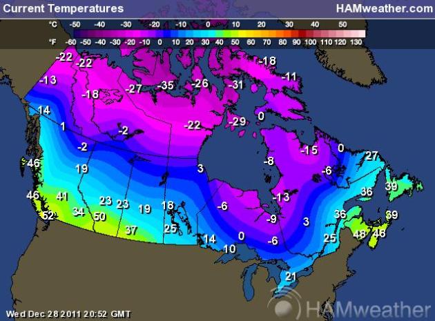
Where's The Cold Air? People have been asking me, "Paul, what's it going to take for a signficant snowfall?" The short answer: a fresh burst of arctic air. Our biggest storms spin up along the leading edge of bitter air. The colder the air, the larger the temperature differential, the greater the potential for a major storm, especially if a). it tracks south/east of Minnesota, and b). moves slow enough to tap moisture from the Gulf of Mexico. Mid afternoon Wednesday temperatures were well below zero over northern Canada, but there's still no overwhelming evidence that this numbing air is headed south in the forseeable future. Map courtesy of Ham Weather.
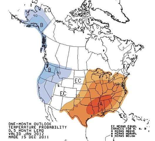
Milder Than Average January? Based on the trends we're witnessing across North America (persistent westerly winds in spite of La Nina) a milder than normal January forecast from
CPC (Climate Prediction Center) seems like a fairly safe bet. No arctic air is imminent, although I can't believe we'll go through the entire winter without a handful of bitter outbreaks. For now it looks like any heavy-duty shivering has been pushed back into the latter half of January and February. Still too early to write off winter just yet.
Year In Wild Weather: 2011. MyFoxOrlando has a good recap of one forgettable year: "
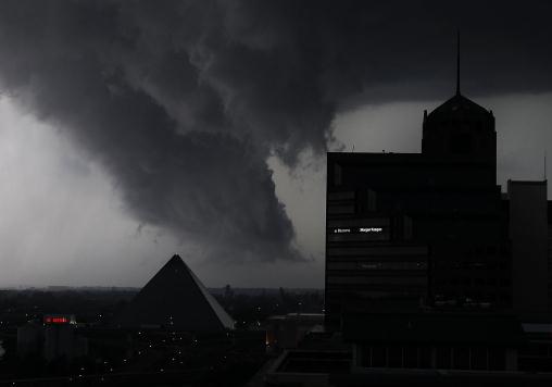
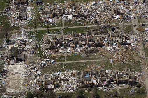
From deadly tornadoes to wicked winter storms, folks all across the country had plenty to deal with in 2011. From hurricanes to an unexpected nor'easter, the headlines in two-thousand-eleven were filled with stories of wild weather and natural disasters. A busy year for firefighters in the west and southwest with triple-digit temperatures and dry conditions sparking thousands of wildfires in Texas, the most devastating blaze in the state's history -- the Bastrop wildfire -- destroying over 30,000 acres. And a deadly year for tornadoes, dangerous twisters ripping across the south back in April reducing thousands of homes to rubbles and killing more than 300 people across seven states. In Alabama alone, more than 200 people were killed."
2011 In Washington D.C. : Warm With Extreme Weather Aplenty. Jason Samenow, meteorologist extraordinaire at the Washington Post's
Capital Weather Gang, takes a look back at a wild year of weather for America's capital: "
Following 2010’s historic weather extremes in Washington (images), headlined by the snowiest winter and hottest summer on record, it seemed unlikely 2011 could rival it. While the summer fell just shy of 2010’s broiling benchmark and the winter was not nearly as snowy, a combination of a memorable 2011 weather events left their mark. From the crippling January 26 snowstorm to the unprecedented heat in July to the tropical torrents of late August and September, 2011 dealt the region a series of punishing weather blows."
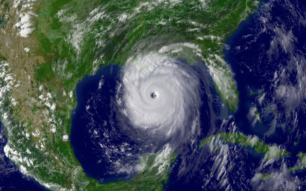
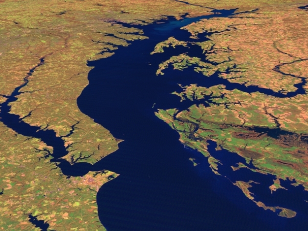
Hurricane Irene Didn't Stir Up Too Much Trouble In The Chesapeake Bay, Scientists Say. Dailypress.com has the story: "
Scientists say the huge sediment plume that lumbered down Chesapeake Bay following Hurricane Irene and Tropical Storm Lee didn’t cause the widespread damage they feared. The Susquehanna Flats, a circular area where the Susquehanna River meets the bay, was perhaps the biggest area of concern. Scientists feared the plume, which stretched dozens of miles, would destroy underwater grass beds used by blue crabs and other organisms to feed and nest. “We were incredibly surprised at how much of the grass beds remained on the Flats,” Robert Orth, a Virginia Institute of Marine Science professor, said in a statement issued by the Chesapeake Bay Program." Photo above courtesy of NASA.
And The Angry Waters Rose. More fallout from Hurricane Irene, this story excerpt courtesy of Albany's
timesunion.com: "
When the rains came, most of us watched the deluge out the window and made sandwiches for supper. Our neighbors by creeks in the Catskills and along riverbanks stood soaking wet as floodwaters consumed their homes. For most of us, Irene was little more than a headache. For many others, it was the 500-year-flood, the storm of the century. Entire lives washed downstream. Houses and horses. Cars and cattle. School buses and bridge trusses. Then, mercifully, the sun came out. People piled their washing machines, entire wardrobes and all the living-room furniture on the curb. Any community can be measured by how it responds to tragedy. Irene, and then Lee, brought us together. The tropical storms — the remnants of two hurricanes that roared up the East Coast — dumped a foot of rain on some places."
"
Promise only what you can deliver. Then deliver more than you promise." - author unknown.
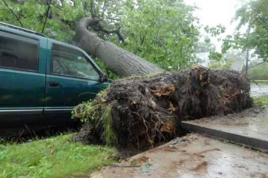
How To Deal With Storm-Damaged Trees.
Oregonlive.com has some good advice about how to deal with downed trees after a major storm. I know, what's a "storm"? "
For consumers seeking a tree service company to help them with downed or damaged trees, the Oregon Department of Forestry offers these tips:
• Hire a company that is bonded and insured and that has a certified arborist.
• Beware of door-knockers, whose low prices may ultimately prove costly. Take your time to select a reputable company, and avoid hiring anyone who will top a tree.
• Since arborists are in high demand after severe storms, it may pay to wait a while if your tree isn't an imminent hazard. "
* Photo above courtesy of The Oregonian.
Top 10 Reasons Why Large Companies Fail To Keep Their Best Talent. Here's an article from
Forbes:
"1. Big Company Bureaucracy. This is probably the #1 reason we hear after the fact from disenchanted employees. However, it’s usually a reason that masks the real reason. No one likes rules that make no sense. But, when top talent is complaining along these lines, it’s usually a sign that they didn’t feel as if they had a say in these rules. They were simply told to follow along and get with the program. No voice in the process and really talented people say “check please.”
2. Failing to Find a Project for the Talent that Ignites Their Passion. Big companies have many moving parts — by definition. Therefore, they usually don’t have people going around to their best and brightest asking them if they’re enjoying their current projects or if they want to work on something new that they’re really interested in which would help the company."
iPhone 5 Rumors Start Heating Up.
Mashable.com has the latest. Yep, I'm an Apple fan-boy. That's one of my better qualities, come to think of it: "
The second round of iPhone 5 rumors has officially begun, speculating a redesigned front rim in rubber or plastic, possibly to connect the face to a new aluminum back plate or to cover a new antenna system. BGR says a source close to the company claims the iPhone will launch next fall, around the time the iPhone 4S launched this year. Pop Herald is predicting a 4-inch screen, which would require app developers to overhaul their products to avoid poor resolution."
More iRumors: New iPad3 On Steve Jobs' February 24 Birthday? The story from
yourversion.com:
"FocusTaiwan reports (via 9to5Mac) that Apple pushing its manufacturing partners to meet deadlines that would allow the company to launch the iPad on Steve Jobs' birthday, February 24th. A local Chinese-language newspaper reported Friday that iPad3 might be launched on Feb. 24 to mark the anniversary of the birth of Apple's late co-founder Steve Jobs. Citing sources close to Taiwanese makers in the iPad3 supply chain, the Economic Daily News said the gadget could be launched in mid-first quarter of next year or by the end of next March. According to the report, workers at several iPad component suppliers as well as manufacturing partner Foxconn will have limited time off during the usual Lunar New Year holiday. The Lunar New Year holiday itself falls on January 23rd next year, with workers generally receiving a number of other days off from work around that date."
Eweek.com has some details on what features may be coming in the new iPad: "
But Apple’s plans for the actual devices remain more opaque. Here are a few possibilities:
Siri: Apple’s “digital assistant” is a prime selling point of the new iPhone 4S, and rumors have circulated for some time that Apple plans to build it into a television set scheduled for launch either in late 2012 or early 2013. If Apple’s truly focused on making Siri a big part of its ecosystem, it stands to reason that the technology will find its way to the iPad sooner rather than later.
Retina Display: Various Apple-centric sources, including the blog 9to5Mac, have compiled rumors over the past few months indicating that Apple is planning on some sort of higher resolution display for the next iPad, possibly of the same quality as the Retina Display currently available in later-model iPhones.
Improved Camera: The iPhone 4S features an 8-megapixel camera, which could also find its way into the iPad 3."
The Scientific Formula For Predicting A Hit Song. I have a son who's an accomplished musician (plays a mean lead guitar). Not sure if you can quanitfy creativity, but this article at
gizmag.com caught my eye: "
You hear a new song. Will it be a hit or a flop? Researchers from Bristol University in the U.K. say they can now tell you - well, sort of. After studying the Top 40 singles charts over the last 50 years and examining the audio characteristics for hits and flops, the team has come up with a formula as to what makes for a successful song and used it to devise software that "predicts" hits. The next step is a web app to allow budding musicians to score their own songs. The prediction characteristics include musical features such as time signature, tempo, beat-variation, "danceability," as well as the harmonic simplicity of the songs and how noisy/loud they are. Importantly, these variables are examined for how they shift over time so in a sense, it is a shifting formula."
"
The best way to predict your future is to create it." - Peter Drucker.
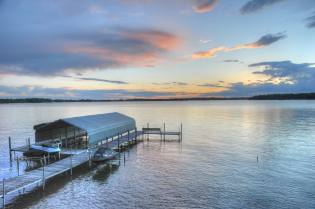
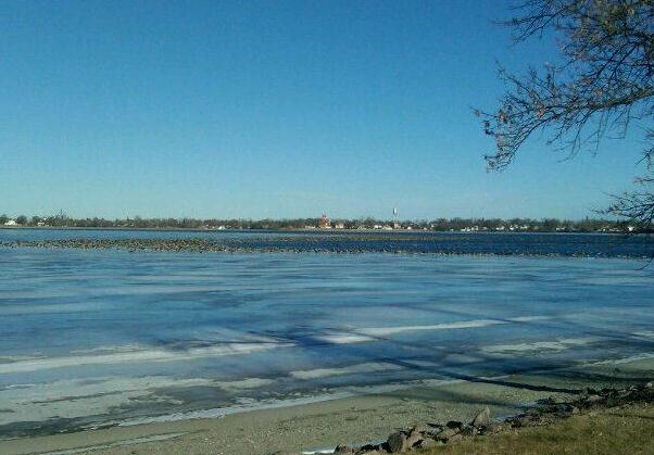
 Toqua Lake
. Look closely and you can see thousands of geese (and open water) in the middle of the lake - photo courtesy of Peter Tharaldson.
Why Fly South?
Maybe the birds know something we don't? Best Buy's Peter Tharaldson sent me a Facebook post and photo, showing thousands of geese on Toqua Lake, near Graceville, in far west central Minnesota.
"The geese never flew south. There are about 6000 (geese) sitting on this lake and they actually create enough stir to keep a section of water open."
The MN State Climate Office's Pete Boulay sent some breaking news: the second half of 2012 was the second warmest since 1873 in the Twin Cities; temperatures nearly 5 degrees F. above average. We've had 18 days above freezing this month, 6 days above 40; no subzero nights. Amazing.
Based on heating degree data we've saved 20% heating homes and business over a "typical winter". Whatever that is.
And the Arctic Oscillation Index, a measure of how strong westerly jet stream winds are across North America, shows a continuation of unseasonable warmth into the first half of January. No, I don't think we'll have a "Year Without A Winter", but we may come close.
A light mix up north tapers today - A slushy couple of inches of "snow" (you remember snow, right?) possible here Saturday night. Before that happens a south wind should boost the mercury into the 40s for an almost March-like New Year's Eve.
Climate Stories...
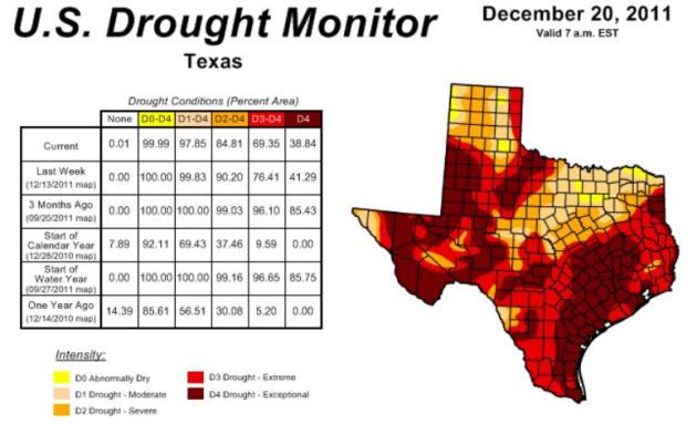 Recall: Punishing Drought Just Getting Started In Texas
. From the
San Antonio Current: "
Natural weather cycles delivered the worst one-year drought in the historic record to Texas in 2011. Scientists examining tree rings had to go back as far as 1789 to find a worse one. It was global climate change, however, that supplied the added heat that further reduced precipitation and exacerbated an already ugly dryness into levels of record-breaking heat. When Texas state Rep. Doug Miller suggested that State Climatologist John Nielsen-Gammon had said climate change was not involved, the typically cautious, Bush-appointee offered the Current his correction: "Global warming contributed to the high temperatures, especially with this drought. So it enhanced evaporation and decreased water supply and therefore made the drought more intense then it would otherwise have been." Map above courtesy of NOAA's
Drought Monitor.
Why Agriculture Needs To Catch Up On Climate Change Action. The story from
greenbiz.com: "
Farmers know weather. They know that the rainfall and temperature patterns that they depend on for productive yields are increasingly volatile. Agriculture is one of the first sectors that will be seriously affected by climate change. We're already seeing the impacts: the record-breaking drought and heat wave in Texas this year, for example, greatly depressed peanut yields, tripled prices for processors and led to a consumer price increase of 30-40 percent on peanut butter, the Wall Street Journal reported. Climate change will likely impact average temperatures, and the frequency of heat waves and extreme weather events, including storms, floods and droughts, is expected to increase, all with repercussions that will be felt by the agriculture sector."


