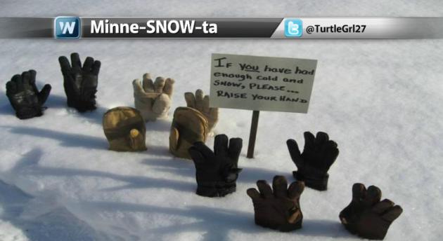
Deja Vu??
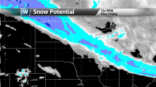
Here we go again with ANOTHER clipper diving into the Lower 48. Friday is expected to be a little snowy for some across the Upper Mississippi Valley as the 2nd punch of wintry weather glides through the area. This event should be a little more substantial than that of the Thursday system. There appears to be a more widespread area of slightly heavier totals from North Dakota to the Ohio Valley. Winds are also expected to pick up behind the system, so there could be a little blowing snow to contend with as colder air wraps in behind it.
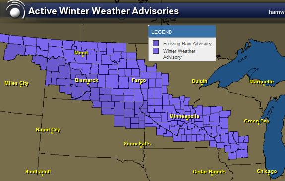
A STORM SYSTEM WILL BEGIN TO ORGANIZE ACROSS THE NORTHERN PLAINS LATER THIS EVENING AND MOVE SOUTHEAST ACROSS THE UPPER MIDWEST THROUGH SATURDAY MORNING. INITIALLY...WARMER TEMPERATURES ALOFT WILL CAUSE PRECIPITATION TO FALL IN THE FORM OF FREEZING RAIN AND SLEET FOR AREAS SOUTH OF INTERSTATE 94...WITH THE PREDOMINANT TYPE OF FREEZING RAIN FOR AREAS ALONG THE MINNESOTA RIVER VALLEY...SOUTHWARD TO THE IOWA BORDER. AREAS NORTH OF INTERSTATE 94 WILL HAVE A MIXTURE OF SLEET AND SNOW...POSSIBLY SOME FREEZING RAIN EARLY...BEFORE CHANGING TO SNOW BY FRIDAY MORNING. ONCE COLDER AIR MOVES ACROSS THE AREA FRIDAY MORNING...THE PRECIPITATION WILL CHANGE OVER TO ALL SNOW. THERE WILL BE A LULL IN THE PRECIPITATION FRIDAY MORNING...BEFORE THE NEXT WAVE OF SNOWFALL DEVELOPS DURING THE AFTERNOON. BY SATURDAY MORNING... SNOWFALL AMOUNTS WILL RANGE FROM 4 TO 6 INCHES NORTH OF AN ALEXANDRIA TO SAINT CLOUD MINNESOTA...TO EAU CLAIRE WISCONSIN LINE. AREAS SOUTH OF MORRIS TO THE TWIN CITIES AND RED WING WILL LIKELY SEE AMOUNTS RANGING FROM 1 TO 4 INCHES...WITH ICE ACCUMULATIONS OF ONE TENTH OF AN INCH ALONG THE MINNESOTA RIVER VALLEY...TO THE IOWA BORDER.
...WINTER WEATHER ADVISORY IN EFFECT FROM 1 AM FRIDAY TO 1 AM CDT
SATURDAY...
THE NATIONAL WEATHER SERVICE IN TWIN CITIES/CHANHASSEN HAS ISSUED
A WINTER WEATHER ADVISORY FOR SNOW...SLEET AND FREEZING RAIN...WHICH
IS IN EFFECT FROM 1 AM FRIDAY TO 1 AM CDT SATURDAY.
A WINTER WEATHER ADVISORY IS IN EFFECT FROM 1 AM FRIDAY...TO 1 AM
SATURDAY MORNING.
* TIMING: A MIXTURE OF SLEET AND SNOW...POSSIBLY MIXED WITH
FREEZING RAIN WILL DEVELOP ACROSS WEST CENTRAL MINNESOTA AFTER
MIDNIGHT AND SPREAD SOUTHEAST OVERNIGHT. THE MIXTURE OF
PRECIPITATION WILL CHANGE OVER TO ALL SNOW BY FRIDAY MORNING.
* MAIN IMPACT: TOTAL SNOWFALL BY LATE FRIDAY NIGHT WILL RANGE FROM
4 TO 6 INCHES NORTH OF AN ALEXANDRIA TO SAINT CLOUD
MINNESOTA...TO EAU CLAIRE WISCONSIN LINE...TO ONE TO FOUR INCHES
SOUTH OF THIS LINE. ICE ACCUMULATIONS OF ONE TENTH OF AN INCH
ALONG THE MINNESOTA RIVER VALLEY...TO THE IOWA BORDER.
* OTHER IMPACTS: ICE AND SNOW WILL CAUSE TRAVEL DIFFICULTIES. BE
PREPARED FOR SLIPPERY ROADS.
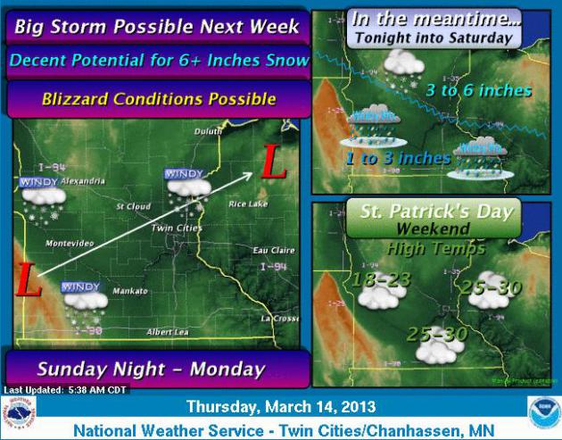
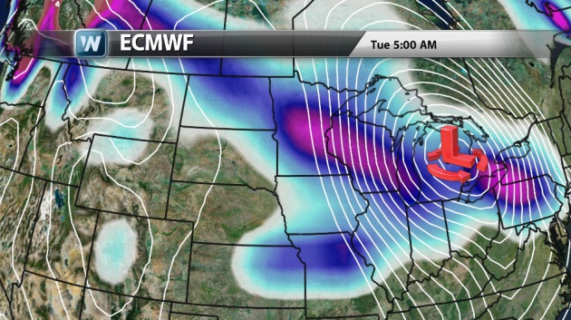
Don't Put Away the Shovels Just Yet!
Unreal... Another storm is forecast to drift through the area Sunday thru AM Tuesday with even more snow! This one looks potentially even more substantial that that of the Friday system. Although the exact details of the system are yet to be determined, expect another nasty commute on Monday... Stay tuned for more!
Ask Paul/Todd Weather Questions...
Terry Schacht Asks:
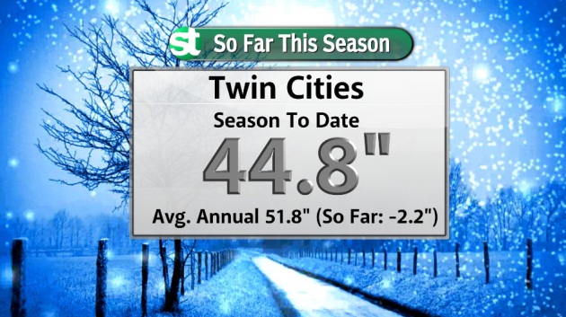
"I was saying in the office today that this winter 2012-2013 so far is about an average winter for snow fall. So how much snow has fallen in the twin cities this winter?"
Thanks for you question Terry... the official reading from the Minneapolis/St. Paul International Airport (thru March 13th) was 44.8", which thru that date was -2.2" below normal. Yes, you are correct, we are sitting around normal for the season and could be at a surplus by early next week with our upcoming snow chances.
Interestingly, thru the months of November, December and January, we had only seen 20.4" of snow (over a 92 day period). Since the beginning of February (thru March 13th), we've seen 24.4" (over a 41 day period). That means we've seen more snow in nearly half the time (Feb. - Mar. 13th) that we had thru all of (Nov. Dec. & Jan.).
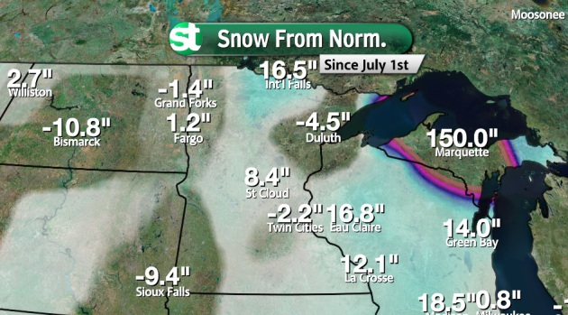
Seasonal Snow From Normal
In case you're interested... Listed below are the seasonal snow from normal amounts across the region. This is how much above or below we are from normal snowfall so far this season. NOTE: Marquette, MI IS NOT 150" above normal... That's an error. Marquette, MI is really -8.2" below normal for the season, keep in mind that they've seen over 170" of snow for the season thus far!
Fun With Pi
I couldn't resist a few more "Pi" pictures... I had a little fun with the weather graphics on Thursday! LOL

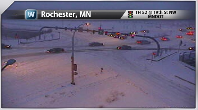
If Thursday morning's commute was just another reminder of how sick and tired folks are of winter. I got a call from my wife saying that she had been sitting in traffic for 2 hours... a drive that normally takes maybe 30mins to 45mins... UGH! I guess that's one benefit of my early morning shift is that no matter what kind of weather, driving the roads at 3am, there isn't too much traffic! We may see another rough commute during the PM Friday timeframe as another clipper moves in.
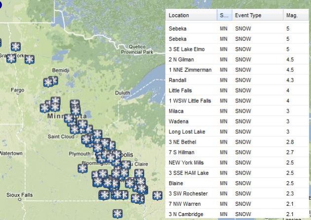
IMAGES BELOW WERE TAKEN AM THURSDAY...
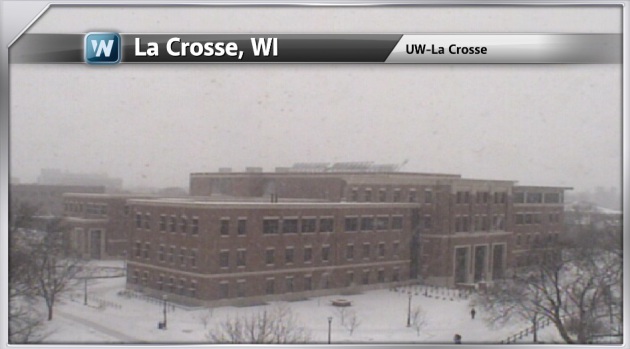
TOP MN Snowfall Tallies From AM Thursday Clipper
Here are some of the top snowfall tallies across MN from AM Thursday's clipper. The official Minneapolis/St. Paul International Airport report was only 0.6"
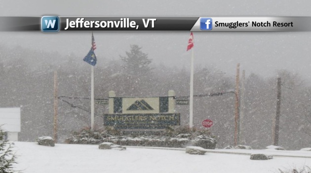
Snowy Thursday in the Northeast
Not only were folks in the Midwest dealing with snow on Thursday, but folks in the Noreast had snow too! I think there are several people that are getting irrationally optimistic about Spring to finally rear its head!
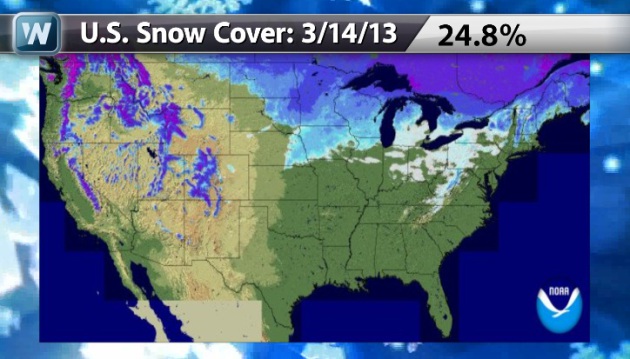
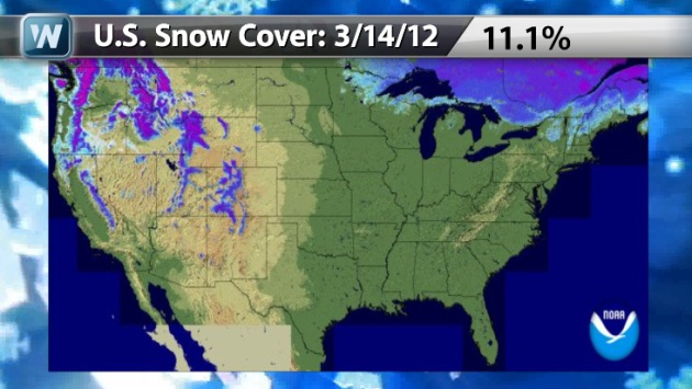
U.S. Snow Cover 2012 vs. 2013
As of March 14th, the national
snow cover was sitting at nearly 25%, which was quite a bit different
from where we were last year at this time... only 11.1% of the nation
was covered in snow.
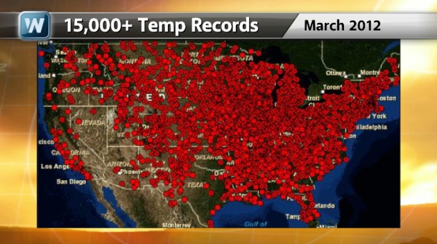
Much Different March 2012
Take a look at the March 2012
Temperature Rankings by state below. The red colored states that are
labeled 118 were considered to be the warmest March on record for those
respective states! Note how many there were!!
Extremely Rare March 2012
Incredibly, there were over 15,000 temperature records set last year!
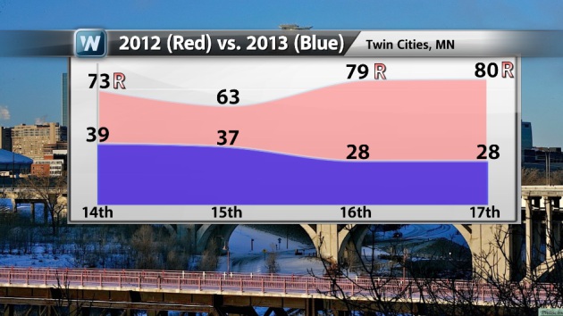
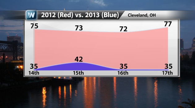
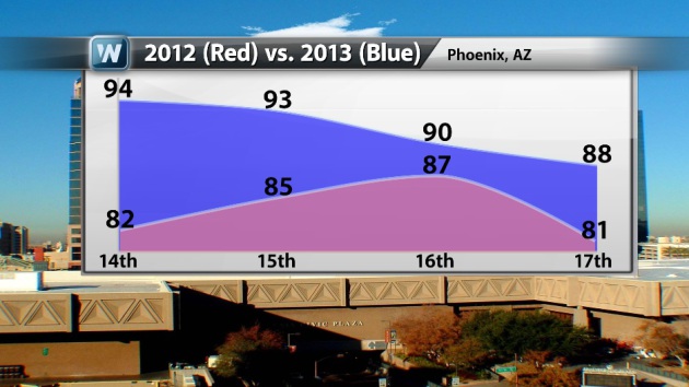
March 2012 vs. 2013 by the Cities
Here are a few cities and their
temperatures during a stretch of days from 2012 to 2013. Note the
difference temperatures especially in Minneapolis, MN and Cleveland, OH!
Note that Phoenix, AZ is dealing with some slightly warmer conditions now than what we had last year at this time!
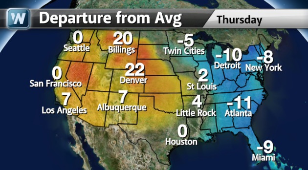
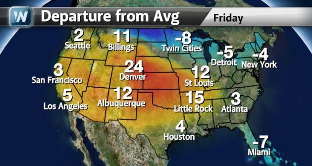
National High Temperatures Departure From Normal
The maps below show how much
warmer or colder the high temperature was/is expected to be for some
selected cities across the nation for Thursday and Friday.
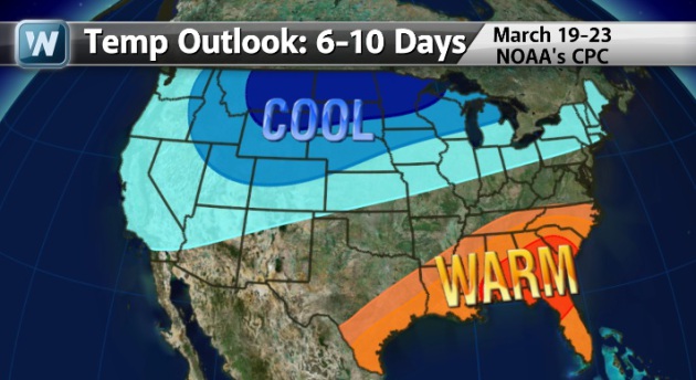
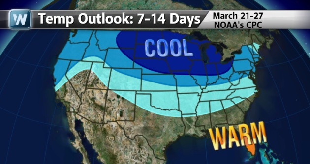
Temperature Outlook
Even after a fairly sizeable
warmup for folks across the western half of the country, the extended
temperature outlook is looking to be below normal for a large chunk of
the the northern half of the country.
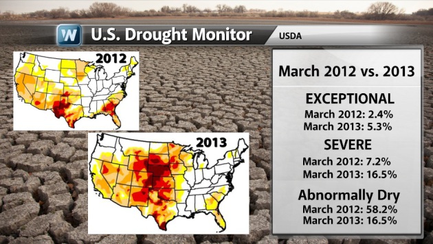
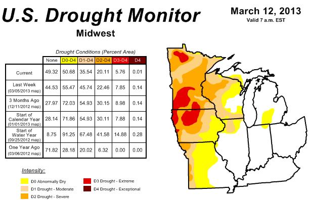
U.S. Drought Monitor Update
I thought this was
interesting... Take a look at the U.S. Drought Monitor from March 2012
vs. March 2013. Note how the drought has expanded across the central
part of the country since last year. Several factor played a role in
this expansion, but the lackluster winter of 2011-2012 and the extremely
hot and dry summer of 2012 were the key factors in this worsening
drought situation.
"The Midwest: Light precipitation (0.5 – 1.5)
inches fell across Michigan and Indiana, so the area of abnormal
dryness (D0) was trimmed slightly. Areas with above-normal rainfall
over the past 30-days were targeted for improvement, but some D0 was
retained due to longer term soil moisture deficits that reflect
long-term drought reaching back to last summer.
Despite significant rains (0.5 – 3.0 inches), only minor improvements were also pursued over Illinois, Wisconsin, and Minnesota. According to some local National Weather Service employees and state climatologists, the frozen ground (10-20 inches of frozen soils) is preventing deep soil moisture recharge. Streams and rivers rose and fell rapidly, indicting excessive runoff and lack of penetration, along with some reports of basement flooding as the water cannot go into the soil.
A nearly 1-category improvement across Missouri and Iowa was prompted by widespread rains (0.5 – 2.5 inches). The improvements were not a full 1-category as some areas of northwest and north-central Missouri did not experience as significant of a soil moisture recovery as points farther east and south, where soils had thawed earlier in the year."
"Looking Ahead: During the next 5 days (March 14-18, 2013), moderate to heavy precipitation is forecast for the Pacific Northwest, northern Rockies, Great Lakes, and Ohio Valley. Outside of those regions, little to no precipitation is expected. Much colder than normal temperatures are likely to support a continuation of the frozen soil problem across the northern Great Plains through the next week, while the Rockies and southern Great Plains are expected to experience warmer than average conditions. Colder than normal conditions are likely to persist through the next 10 days from California to the northern Great Plains to the Northeast, with the most likely locations for above-normal temperatures are across the southeast. Wet conditions are likely to continue for the Great Lakes, northern Great Plains and southeast, with drier than average conditions likely across the southwest."
Read more from the U.S. Drought Monitor HERE:
Thanks for checking in, have a great weekend ahead!
Don't forget to follow me on Twitter @TNelsonWNTV