Friday, February 28, 2014

"March-uary" for much of America (California flooding - significant snow/ice event brewing Ohio Valley to Mid Atlantic)


What March?

You won't realize it walking out the door, but today marks the start of Meteorological Spring. In theory, the 90 coldest days of the year, historically, are behind us now. On paper. Then again you can prove anything with statistics.

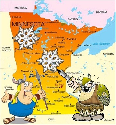
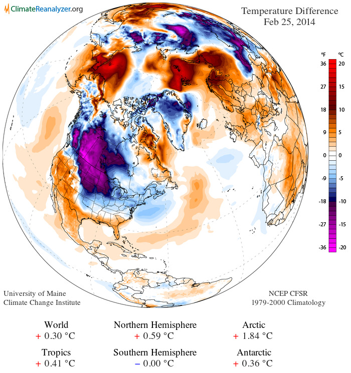
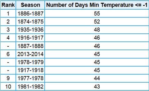
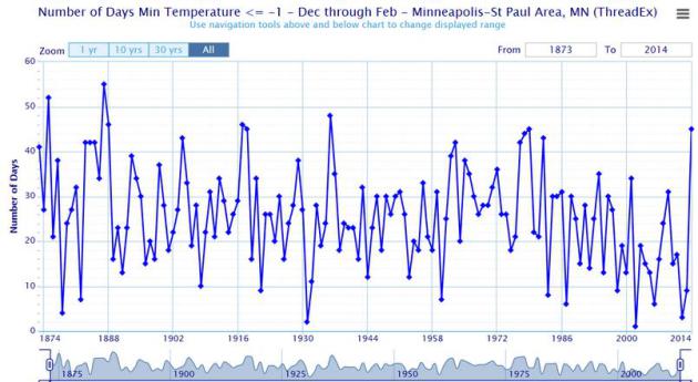
Welcome to a Pioneer Winter, something only Laura Ingalls Wilder could love. 9th coldest Meteorological Winter. 47 subzero nights - 4th most on record - the most nights of negative fun since 1935-36. According to Dr. Mark Seeley, February was the coldest since 1979, "ranking among the 8 coldest months of February on a statewide basis since 1895."

Many of us are counting the days (hours!) until spring break. We've had good luck with Delta Vacations for air/hotel packages, vrbo.com for home rentals, and vacationstogo.com and 90dayticker.com for inexpensive last-minute cruises in years past. No, I don't get a kickback or commission.

Dr. Douglas is just trying to help ease the numbing pain.

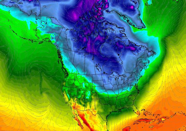
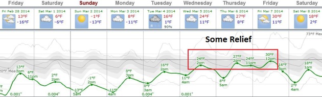
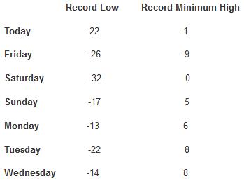
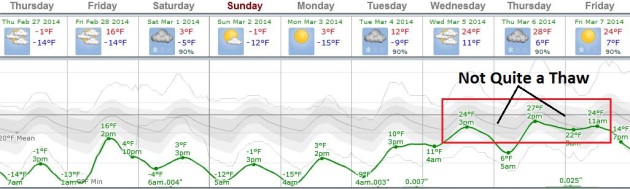
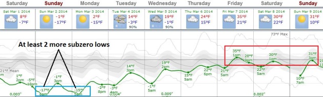
Hard to believe that Canada is exporting more brisk air south of the border - sparking a coating of fluff today; temperatures struggling to near 0F today & Sunday. 20s return next week, 30s by late week. I'd say we're turning a corner, but the way this winter is going I'll remain mum, here tucked away in my (cold and drafty) little house on the prairie.

Measures Of This Cold Winter. Dr. Mark Seeley has a few eye-opening weather nuggets and statistics related to the duration and intensity of the cold across Minnesota in this week's edition of Minnesota WeatherTalk; here's an excerpt: "....For the meteorological winter (Dec-Feb), persistent cold and snow cover have been the themes across Minnesota. On a statewide basis it is the coldest winter since that of 1978-1979 and will likely end up among the top 5 coldest historically. Some measures of the cold winter season include:

* 65 days with below 0 F minimum temperature at Duluth, including a record string of 23 consecutive days from January 20 to February 11
* 70 days with below 0 F minimum temperatures at International Falls
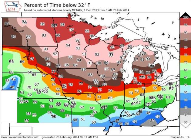
* 50 days with 0 F or colder minimum temperatures in the Twin Cities, over twice the historical average and the most since the winter of 1977-1978.
.."

Subzero Weekend - Then Hints of March. I know we've been sucker-punched by Old Man Winter before. For too many weeks long range guidance (even the normally reliable ECMWF data above) showed warming trends far into the future, only to evaporate. A higher sun angle should make a tangible difference next week; highs in the 30s the end of next week. But first we muddle through another unreasonably cold weekend. Graph: Weatherspark.

Healthy Skepticism. I tell people it's good to be skeptical (about everything). Long range guidance from GFS has been notoriously unreliable much of the winter, hinting at phantom warming trends 1-2 weeks out. But the Son of Polar Vortex shows signs of responding to a higher sun angle next week, and I suspect the long range outlook of (sustained) 30s by mid-March is real. I sure hope so.

45-Day Wish Cast. Here is NOAA's CFS (Climate Forecast System) extended trend looking out into early April, showing a few highs in the 40s by the third week of March, 50s by the first week of April. I show this not because I believe it will verify, but because all of us need a reason to keep on going. Let's hope it's real. Graph above: Ham Weather.


Ask Paul. Weather-related questions, comments and threats:

"Paul, you must be familiar with Laura Ingalls Wilder's book, "The Long Winter." My question for you: are we in a 21st winter?"
Thanks,

Rebecca

Dear Rebecca. The answer is yes. Welcome to a Pioneer Winter, something we may be sharing with kids and grandkids down the road. Laura would certainly identify with our winter (minus the furnaces, heated car seats and cable TV).

Paul,

"We always enjoy your light touch weather humour and intelligent reporting. The other day a two-year old friend was over and wanted a glass of water. She said “ice”. Apparently the young think water in Minnesota is called ice."
Ralph and Kathy Yehle

Thanks Ralph and Kathy - appreciate your kind words. Tell your two year old friend that Minnesota will definitely be more ice than water into most of March.

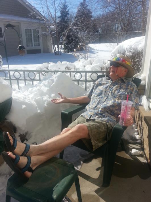
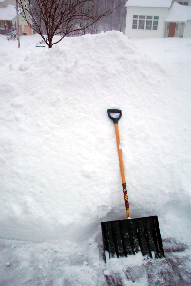
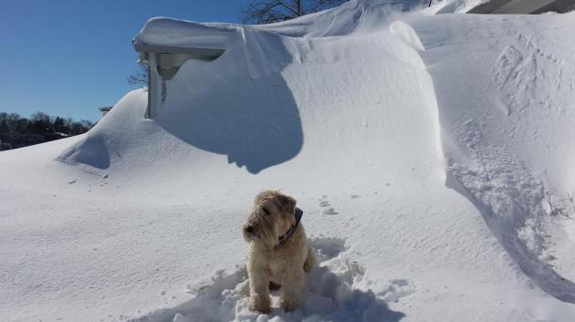
Hey Paul,
We're Minnesotans - we make lemonade!
(Photo of Chuck Shults, Apple Valley, 2/28/2014, taken by Melinda Shults)

4th Most Subzero Nights On Record at MSP. As of Thursday the Twin Cities have experienced 47 nights below zero, the 4th most since 1873. At the rate we're going, with at least 2-3 more nights of subzero fun, I suspect we'll wind up 3rd on the all-time list, potentially more subzero nights than 1935-36. Source: Twin Cities National Weather Service.

Bucking The Trend. We've seen fewer subzero nights, on average, since about 1980s, a gradual decline in the number of pioneer winters. But this winter is proving to be the exception. Source: Twin Cities National Weather Service.

Alerts Broadcaster Briefing: Issued Friday afternoon, February 28, 2014.

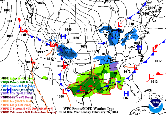
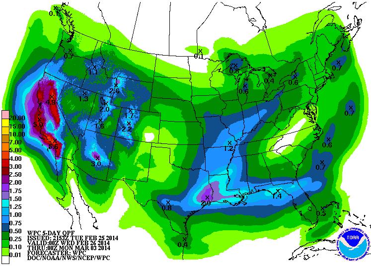
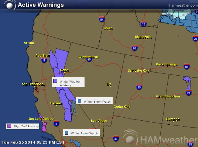
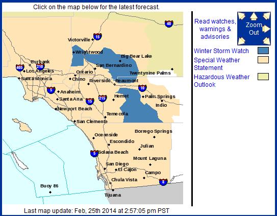
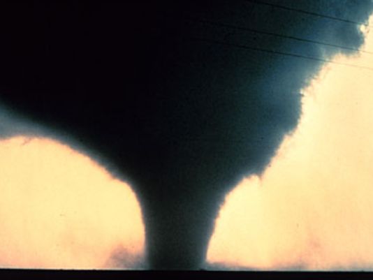
* Risk of small, isolated tornadoes over southern California into the late evening hours, including Los Angeles and San Diego.
* Flash flood risk southern California with some locally heavy 1-3" rainfall amounts - flooding of streets and poor drainage areas likely, impacting travel. Coastal flood warnings are posted for most of southern California for severe beach erosion and coastal flooding, especially close to high tide.
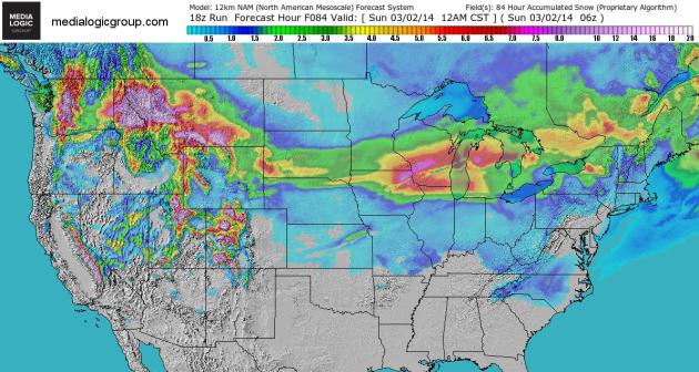
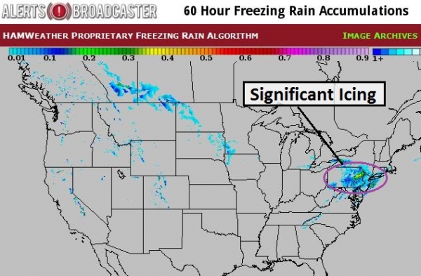
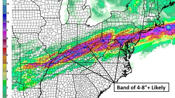
* Potential for a band of heavy snow and ice stretching from the Ohio Valley into the Mid Atlantic Region Sunday and Monday. Plowable amounts of snow are likely, with enough ice accumulation for possible power outages, especially across portions of the Ohio Valley.
* Heavy snow cover northern USA + potential for rapid warming in March means a heightened risk of flash flooding and river flooding by late March from the Twin Cities to Chicago, Detroit and New England. A preview of the risk below.

Tornadoes In Unlikely Places. Although the potential is small, it's worth alerting on a risk of (isolated) severe T-storms across southern California today into Saturday. A very small percentage of these severe storms may produce small, brief tornadoes. The map above is from Alerts Broadcaster's proprietary TPI, or Tornado Potential Index. The yellow regions show the greatest risk of tornado development into the late evening hours. Map credit above: Ham Weather.

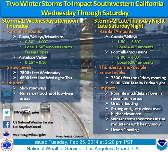
More on the growing Flash Flood Potential for southern California:

...FLASH FLOOD WATCHES HAVE BEEN EXPANDED TO INCLUDE ALL OF LOS
ANGELES AND VENTURA COUNTIES THROUGH SATURDAY EVENING...
 
A VERY STRONG AND DYNAMIC STORM WILL CONTINUE TO BRING BANDS OF
HEAVY RAIN AND POSSIBLE THUNDERSTORMS TO MUCH OF SOUTHWESTERN
CALIFORNIA THROUGH SATURDAY EVENING. A FLASH FLOOD WATCH HAS BEEN
EXPANDED TO INCLUDE ALL OF LOS ANGELES AND VENTURA COUNTIES AS
RAINFALL RATES COULD LOCALLY EXCEED ONE INCH PER HOUR NEAR
THUNDERSTORMS. RECENT BURN AREAS OF LOS ANGELES AND VENTURA COUNTIES
WILL CONTINUE TO BE MOST SUSCEPTIBLE TO DANGEROUS FLASH FLOODING
AND SIGNIFICANT MUD AND DEBRIS FLOWS.

A Rough 36 Hours For Southern California. From Flash Flood Watches to small hail, damaging wind gusts and isolated tornadoes, coastal California will experience a significant storm into Saturday night. Coastal flooding is likely with this storm, especially close to high tide. Map credit: NOAA. Details:

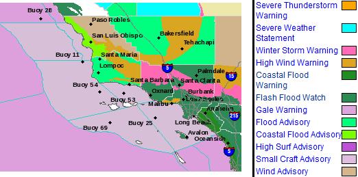
...COASTAL FLOOD WARNING REMAINS IN EFFECT UNTIL 1 AM PST
   SUNDAY...
...HIGH SURF ADVISORY REMAINS IN EFFECT FROM 4 AM SATURDAY TO
  4 AM PST MONDAY...
* COASTAL FLOODING...WIDESPREAD MINOR COASTAL FLOODING EXPECTED DURING
  TIMES OF HIGH TIDE. SOME MORE VULNERABLE LOCATIONS MAY
  EXPERIENCE COASTAL FLOODING SIGNIFICANT ENOUGH TO CAUSE PROPERTY
  DAMAGE AND INUNDATION OF LOW-LYING BUILDINGS AND STRUCTURES
  ALONG THE BEACHES.
 
* IMPACTS...COASTAL FLOODING COULD CAUSE DAMAGE TO BEACH-FRONT
  PROPERTY IF PROPER PRECAUTIONS ARE NOT TAKEN. LARGE AND ROUGH
  SURF...ALONG WITH STRONG RIP CURRENTS...WILL CREATE HAZARDOUS
  CONDITIONS FOR SWIMMERS AND SURFERS. SURF...LARGE TIDAL
  SWINGS...AND PRECIPITATION MAY RESULT IN MODERATE TO
  SIGNIFICANT BEACH EROSION.

Ice Potential. It's still early, but some high-resolution models show a band of rain freezing on contact, with a risk of significant icing Sunday and Sunday night from near St. Louis to Indianapolis and Columbus, possibly extending into Washington D.C., Baltimore and the Delaware Valley during the day Monday. If these ice accumulation predictions verify there would be sporadic power outages (often half an inch of glaze ice is all that's required to bring down some power lines). Map credit: Baron Services.

More January Than March. Internal models here at Alerts Broadcaster show a persistent band of heavy snow (mixed with ice) extending from the Midwest and Ohio Valley into the Mid Atlantic Region Sunday night and Monday. Monday appears to be a (very) challenging travel day for Mid Atlantic facilities, including Washington D.C., Baltimore, Philadelphia and New York, where plowable amounts of slushy snow are possible. Precipitation may begin as rain, and then switch over to ice and snow during the day Monday.

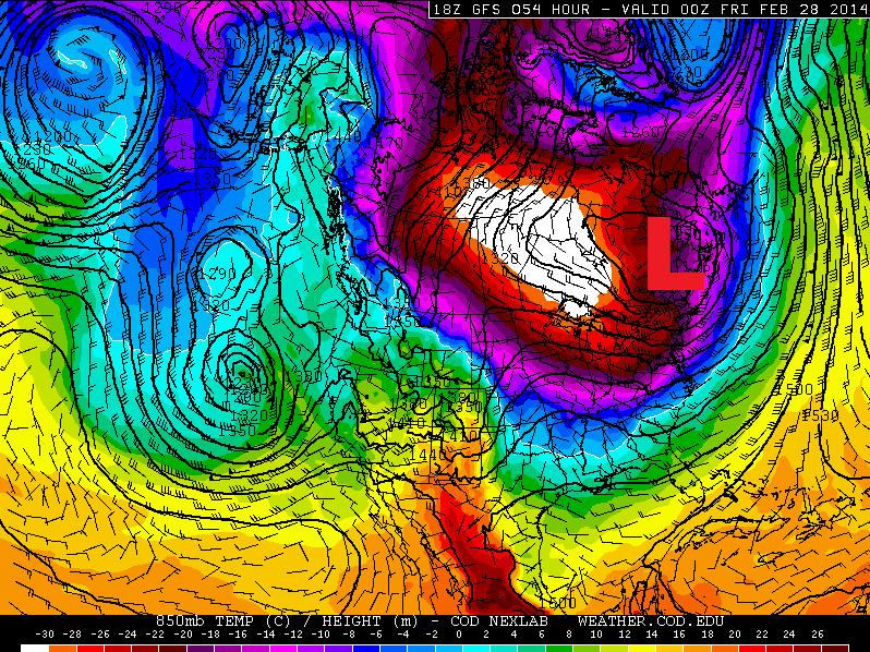
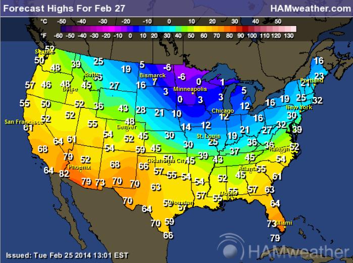
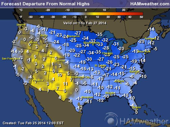
Summary: Never a dull moment in the weather department, especially this winter. The next wave of bitterly cold Canadian air spins up a wave of low pressure from the Midwest and Ohio Valley this weekend, reaching major eastern population centers by Monday, with improving weather by Tuesday of next week.

In another case of severe weather whiplash: Southern California is going from historic drought to flash flooding as a Pacific storm sweeps inland; the heaviest rains and worst coastal flooding and flash flooding from this afternoon into Saturday, with rain diminishing during the day Sunday. Expect flooding of streets, streams and poor drainage areas, impacting air and land travel into tomorrow. Coastal facilities may be impacted by very rough surf capable of beach erosion.

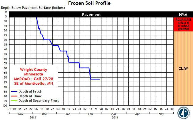
Another subzero airmass pushes across the Upper Mississippi Valley into the Great Lakes this weekend, but models are increasingly suggesting moderation for much of the USA by the latter half of next week. The toughest winter since the late 1970s for America's northern tier may give risk to rapid snow melt and enhanced river flooding risks by late March and early April. It's too early for specifics, but there is significant water tied up in all that snow, as much as 5-10". The potential (and severity) of river flooding will depend on the rate of warming, and whether warm fronts are accompanied by heavy rain, which accelerates snow melt on frozen ground. Frost levels are deeper than I've seen them in 30 years, so any (liquid) water will tend to run off - enhancing the flood risk. We'll keep you posted.

Paul Douglas - Senior Meteorologist - Alerts Broadcaster

Thursday, February 27, 2014

The Real Winter Games (46 subzero nights Twin Cities - most since 1935-36)


The Winter Games

The Winter Olympics are over - all the pomp, drama, hype & melting Sochi slush now history. But we're all reluctant medalists in the Real Winter Olympics. Events have included full frontal aerobic shivering, synchronized shoveling, and the breathtaking & horrific spectacle of freeway-traffic ice-dancing.

Bronze goes to Detroit, enjoying the coldest winter since the Truman Administration. Silver goes to Minnesota; much of the state proud to be colder than any time in 35 years. It’s a photo-finish, but Grand Forks gets Gold; since December 1 a full 99% of the time has been colder than 32F.

I’d get off the podium but my knees are frozen in place.

At some point I hope we’ll have a solid scientific explanation for why the jet stream became locked in a polar flow for 3 months. I suspect rapid warming of the Arctic since 2010 somehow disrupted the polar jet, but I can’t prove it scientifically, not yet. Just a hunch.

The next jab of unreasonably cold air sparks an inch or two today; no controversial storms brewing anytime soon. 2 more subzero lows early next week, then a run of 20s. The models insist we'll be basking in 30s by mid-March.

I'm ready for the Winter Games to be over.

4th Most Subzero Nights On Record at MSP. As of Thursday the Twin Cities have experienced 46 nights below zero, tying for 4th since 1873. At the rate we're going, with at least 2-3 more nights of subzero fun, I suspect we'll wind up 3rd on the all-time list, potentially more subzero nights than 1935-36. Source: Twin Cities National Weather Service.

Bucking The Trend. We've seen fewer subzero nights, on average, since about 1980s, a gradual decline in the number of pioneer winters. But this winter is proving to be the exception. Source: Twin Cities National Weather Service.

Son Of Polar Vortex. Glancing at the maps you'd never believe meteorological spring is hours away. Historically (ha!) the coldest 90 days of the year end right around March 1. As far as the atmosphere is concerned, winter really goes from about December 1 to March 1. Will we have another tortured spring with snow into early May? I doubt it, but with the jet stream perpetually stuck all bets are off. North American temperatures above courtesy of Climate Reanalyzer.

Another Subzero Smack - Then Some Improvement. Clippers today, again Saturday mark the leading edge of yet another Canadian Treat; subzerl lows likely Sunday and Monday morning before some recovery takes place the latter half of next week, with highs in the 20s to near 30 by Thursday and Friday. ECMWF data trends: Weatherspark.

Record Territory. Back in 1963 the Twin Cities endured 23 days worth of hours below zero. We just passed 20 days worth of negative numbers (over 480 hours below zero), according to Daryl Herzmann at the Iowa Environmental Mesonet. Good grief. Make it stop.

Coldest Daytime Highs - More Records Imminent? The short answer appears to be yes. Here's a post from the Twin Cities National Weather Service: "The current cold snap, which is a part of the coldest winter in 35 years, is breaking records again. The coldest high temperatures that have been recorded back to the late 1800s on February 25 through March 2 are listed for the Twin Cities, St. Cloud and Eau Claire.

Percentage Of Time Below Freezing Since December 1. I was feeling pretty blue about the Twin Cities being colder than 32F for over 90% of the time since December 1, the start of Meteorological Winter. And then I saw Grand Forks coming in at 99%. Thanks to Iowa Environmental Mesonet for cheering us up.

National Percentage of Time Below 32F Since December 1. Not much of a break from the Upper Mississippi Valley and Great Lakes into much of New England. Details here.

All-Time Records Next 7 Days (average high at MSP on February 27 is 33F, average low is 18F)
* Thanks to Aaron Shaffer at WeatherNation TV for tracking these down from the Minnesota Climatology Working Group. I can't believe I'm still showing this stuff...

Deep Ground Frost. I've had a few questions about the depth of the frost this super-winter, concerns about wells freezing up, and how deep frost in the ground might escalate run-off and flooding when it does finally decide to warm up. According to MnDOT the depth of the frost near Monticello is between 70-75", which is deeper than I can ever recall.


Wednesday, February 26, 2014

The Persistently, Supernaturally Cold Winter of '14


Minnesota Ice

Here's one thing I've discovered the hard way. Minnesota Nice quickly evaporates when you try to share warm weather travel experiences in late February. "Paul, you can (deleted) your (bleeped) and [censored] your tropical weather patterns!"

Message received.

Now it's all about collective suffering - and surviving long enough to take in any kind of spring break. 10th coldest meteorological winter to date....and counting. That makes this the coldest stretch since December 21 since the brutal winter of 1978-1979, according to the Minnesota Climatology Working Group.

Oh yeah, on paper the 90 coldest days of the year, on average, should come to an end Saturday. Uh huh. Old Man Winter doesn't seem to care. He's stuck in a supernaturally persistent rut; the jet stream remains locked. Natural atmospheric variability, the natural ebb & flow of warm and cold, has been replaced by perpetually polar air - while much of the rest of North America runs a low-grade fever.
Baffling.

Windchill Advisories are in effect today; we may not climb above 0F with a chill factor dipping to -30F. Blizzard Warnings are posted just west of MSP for low visibility in blowing/drifting snow. Highly unusual for late February. Then again, highly unusual is the new normal.

Models hint at 30s by mid-March, but I've lost my faith in long-range models this winter. So far it's been meteorological bait and switch. The honest answer? It WILL warm up. I'm just not sure when.

* Photo above of "Chewie" from Steve Erdahl at the Mtka Yacht Club House on February 23.

Record Territory. Back in 1963 the Twin Cities endured 23 days worth of hours below zero. We just passed 20 days worth of negative numbers (over 480 hours below zero), according to Daryl Herzmann at the Iowa Environmental Mesonet. Good grief. Make it stop.

Percentage Of Time Below Freezing Since December 1. I was feeling pretty blue about the Twin Cities being colder than 32F for over 90% of the time since December 1, the start of Meteorological Winter. And then I saw Grand Forks coming in at 99%. Thanks to Iowa Environmental Mesonet for cheering us up.

National Percentage of Time Below 32F Since December 1. Not much of a break from the Upper Mississippi Valley and Great Lakes into much of New England. Details here.

All-Time Records Next 7 Days (average high at MSP on February 27 is 33F, average low is 18F)
* Thanks to Aaron Shaffer at WeatherNation TV for tracking these down from the Minnesota Climatology Working Group. I can't believe I'm still showing this stuff...

Deep Ground Frost. I've had a few questions about the depth of the frost this super-winter, concerns about wells freezing up, and how deep frost in the ground might escalate run-off and flooding when it does finally decide to warm up. According to MnDOT the depth of the frost near Monticello is between 70-75", which is deeper than I can ever recall.

It May Warm Up A Little Next Week - Or Not. This next wave of the Polar Vortex lingers into Monday, and then temperatures try to recover next week, at least reaching 20s. Not quite a thaw, but beggars can't be choosy. At this point we'll take what we can get. ECMWF data shows 20s the latter half of next week. Graph: Weatherspark.

84 Hour Snowfall Prediction. Here is NOAA's NAM snowfall prediction into Saturday night, showing potentially plowable amounts of snow from the Midwest into the Great Lakes, and portions of the northern Rockes and Cascade Range of Washington State. Map: Ham Weather.


Tuesday, February 25, 2014

WNTV Blog for AM Wednesday: Arctic Plunge Intensifies and Significant Rain and Snow for California

Arizona Hummingbird
Thanks to Rich Koivisto for the image below. Looks like the resident hummingbird is enjoying a quick rest and a sweet treat!


Soggy Outlook Ahead
Take a look at the weather outlook through PM Thursday and note the significant push of moisture across the West Coast. This first big push of moisture will be the first of two through the end of the week.


Precipitation Potential
According to NOAA HPC, the 5 day precipitation forecast looks exceptionally juicy over California through the end of the weekend. In some cases, precipitation amounts could near 3" to 6" or more! Unfortunately, the ground is like concrete from being so dry for so long. There is a substantial flooding risk as runoff could be a major concern.


Western Warns
The National Weather Service  has issued a number of Winter Weather Headlines from the Sierra Nevada Mountains to the San Bernadino Mountains. Significant accumulations of snow may be possible by the time these two storm systems blow through.


Southern California Snow Chances

...WINTER STORM WATCH REMAINS IN EFFECT FROM FRIDAY MORNING THROUGH FRIDAY EVENING... 

* ELEVATION... ABOVE 6000 FEET. * SNOW LEVELS...ABOVE 7000 FEET THURSDAY NIGHT...LOWERING TO AROUND 6000 FEET FOR FRIDAY AFTERNOON AND EVENING...THEN DOWN TO BETWEEN 5000 AND 5500 FEET BY SATURDAY NIGHT. * SNOW ACCUMULATIONS...6 TO 10 INCHES POSSIBLE ABOVE 6000 FEET WITH LOCAL AMOUNTS OF 2 TO 4 FEET ON HIGHER PEAKS...MAINLY ABOVE 7000 FEET. * TIMING...PRECIPITATION DEVELOPS LATE THURSDAY NIGHT. SNOW LEVELS WILL LOWER DURING THE DAY FRIDAY WITH SNOWFALL BECOMING HEAVY AT TIMES FRIDAY MORNING THROUGH FRIDAY AFTERNOON. * LOCATIONS INCLUDE: PINE COVE...ANGELUS OAKS...BALDWIN LAKE... BARTON FLATS...BIG BEAR CITY...BIG BEAR LAKE...FAWNSKIN... FOREST FALLS...RUNNING SPRINGS...WRIGHTWOOD * WINDS...SOUTH TO SOUTHWEST 25 TO 35 MPH WITH GUSTS TO 60 MPH. * VISIBILITY...NEAR ZERO AT TIMES IN HEAVY SNOW...BLOWING SNOW...AND DENSE FOG. * IMPACTS...RESIDENTS AND TRAVELERS INTO HIGHER ELEVATIONS OF THE MOUNTAINS SHOULD BE PREPARED FOR HAZARDOUS WINTER WEATHER CONDITIONS AND POSSIBLE ROAD CLOSURES. IF POSSIBLE...CARRY CHAINS AND TAKE EXTRA FOOD AND CLOTHING. * OUTLOOK...SNOW SHOWERS ARE EXPECTED TO CONTINUE FRIDAY NIGHT THROUGH THE WEEKEND WITH THE SNOW LEVEL LOWERING TO 5000 TO 5500 FEET FOR SATURDAY NIGHT THROUGH SUNDAY.


Here's more information from the National Weather Service out of Los Angeles/Oxnard, CA about the storm coming later this week:

See more from the NWS HERE:

Two storm systems are on track to impact southwestern California Wednesday through Saturday The first storm is expected to move across the area Wednesday afternoon through Thursday, bringing light to moderate rainfall to the area with about one half to one inch of rain for most locations and a few inches of snow accumulation above 7000 feet. From late Thursday night through late Saturday night, a second and much stronger system will affect the region with significant rainfall, heavy snow in the high mountain elevations, strong and gusty winds at times over higher terrain, scattered thunderstorms, and the threat of mud and debris flows in and below recent burn areas. One and a half to two and a half inches of rainfall is likely in coastal and valley areas, and two to four inches is likely in the foothills and mountains. Due to strong southerly flow ahead of the storm, locally higher amounts up to six inches are possible in favored upslope areas in the local mountains. Snow levels will remain high on Friday morning at above 7500 feet, but will drop to between 5500 and 6000 feet by Friday night, then drop further to 5000 to 5500 feet on Saturday. Snow accumulations of up to 1 to 2 feet will be possible mainly above 7000 feet. Winter storm conditions can be expected in the higher mountain elevations due to heavy snowfall and gusty winds. Additionally, this storm will be rather dynamic and thunderstorms may develop which could produce intense short-duration rainfall and small hail. Communities in and around recent wildfires, especially the Colby, Madison, Powerhouse, Madre, and Springs burn areas, will need to be alert for heavy and intense rainfall which could produce mud and debris flows. Drainage areas should be cleared of debris to help reduce the chance of urban flooding. 


Significant Cold For End of February
Here's the temperature anomaly from February 25th, which shows a large blog of much colder than average air draining down into the Lower 48.


A Look Ahead
Here's the outlook for Thursday, which doesn't look much better as another surge of Arctic air settles south of the international border.


Highs Thursday
High temperatures on Thursday looks significantly colder  across the Upper Mississippi Valley, while the warmth across the Southwest continues for now.


Highs From Normal Thursday
UGH!


Northern Lights Potential
The strongest flare of the year thus far erupted on the sun on Tuesday. The good news is that this particular flare will only graze the Earth!
Radio emissions from shock waves at the leading edge of the CME suggest an expansion velocity near 2000 km/s or 4.4 million mph. If such a fast-moving cloud did strike Earth, the resulting geomagnetic storms could be severe. However, because its trajectory is so far off the sun-Earth line, the CME will deliver a no more than a glancing blow. NOAA forecasters expect a weak impact late in the day on Feb. 26th.

Read more from SpaceWeather.com HERE:


Northern Lights Forecast
Here's the latest northern lights forecast for Wednesday, which shows an active outlook.
See more HERE:


See also a more in depth look from Jim Thomas who runs SoftServeNews.com and a VERY bookmark worthy link when northern lights may be possible!


Giant Walls to Protect the U.S. form Tornadoes?
Now here's an interesting take on how to control tornadoes across the United States. This story comes from USA Today

"Forget the Great Wall of China… How about the Great Wall of ….. Kansas?
One scientist thinks we can protect parts of the central USA from ferocious tornadoes by building several gigantic walls across Tornado Alley:
"If we build three east-west great walls in the American Midwest .... one in North Dakota, one along the border between Kansas and Oklahoma to the east, and the third one in south Texas and Louisiana, we will diminish the tornado threats in the Tornado Alley forever," according to physicist Rongjia Tao of Temple University.
The walls would need to be about 1,000 feet high and 150 feet wide, he said. Tao is presenting his research next week at the annual meeting of the American Physical Society in Denver."

See the full story HERE:


Thanks for checking in and have a great rest of your week.
Don't forget to follow me on Twitter @TNelsonWNTV