Clipper Fest Continues
We're still not done with light snow chances this week. It appears that another clipper (slightly more robust than Tuesday's) will drop through the region Thursday and Friday with some light snow potential. There could be a little light accumulation as well.

March 2012 vs. 2013
Do you remember March 2012? How about that it was the WARMEST March on record! There were several daytime high temperature records including the 80F on March 17th, which also became the earliest 80F in March. There were also eight 70F degree days or warmer, which became the most ever recorded in March. Spring got a VERY early start last year as flowers were already in bloom! This year, we're still hosting 6" of snow on the ground 'officially' at the Minneapolis/St. Paul International Airport and more snow may be on the way through next week.
"Mother Nature is rearranging her trophy case. An unprecedented mid-March influx of warm, moist air has produced record-setting temperatures for many locations east of the Rockies, including Minnesota.
During this warm stretch, the maximum temperature in the Twin Cities has reached or exceeded 70 degrees on eight days, breaking the previous March record of five set in 1910. Through March 19, the Twin Cities maximum temperature reached or exceeded 70 degrees for four consecutive days, breaking the previous record of three consecutive days which occurred on March 23-25, 1939 and March 22-24, 1945.
When the Twin Cities temperature reached 80 dgrees on March 17, it was the first 80 degree temperature since October 9, 2011. The span without 80 degree temperatures was 159 days, the fewest consecutive number of days without 80 degrees in the modern record."
See more from climate.umn.edu HERE:


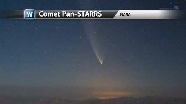
Comet Pan-STARR ...
Folks may remember a familiar name "Hale-Bopp" from comet fame of 1997... From what I could find, that was the last comet visible from Earth. Star and comet gazers alike will be happy to know that another comet will be visible over the next several days (depending on cloud cover).
"Throughout March 2013. The comet could be visible in the Northern Hemisphere evening sky low in the west after sunset. It will move northward each evening during March 2013 as it moves from being in front of the constellation Pisces to being in front of the constellations Pegasus and Andromeda. At this time, the comet might have a bright dust tail, and perhaps visible to the unaided eye or binoculars. It should, at least, if it lives up to expectations. Remember to look for the comet in the vicinity of the waxing crescent moon on March 12, 13 and 14. The comet swings above the star Algenib on March 17/18, and above the star Alpheratz on March 25/26."
Read more from earthsky.org HERE:
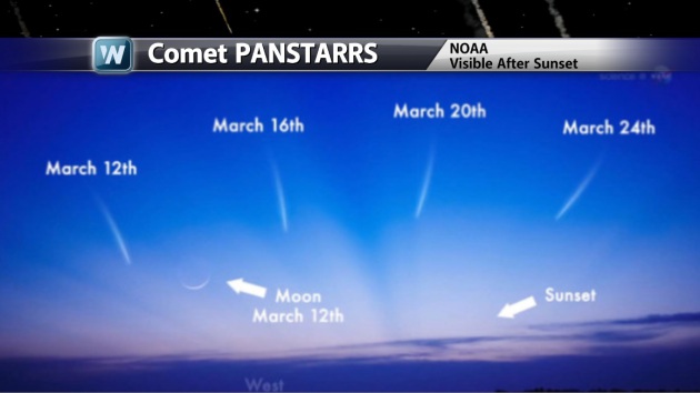
Comet Pan-STARRS Viewing Potential
If you're lucky, Comet Pan-STARRS will be visible during the evening hour just after sunset in the western sky. Look low on the horizon, it should be visible for a time just after sunset over the next several days! Good Luck! Tweet me a picture if you happen to get a good one, I'll use it on WeatherNation TV -- Tweet me @TNelsonWNTV
Sick of the Snow?
Either you love it or you hate it, but no doubt we're starting to make strides towards a warmer atmosphere. March is typically a big transition month for the nation and cold air retreats and warmer air puts a dent in the winter snowpack. March is still a fairly big snow producing month for many as this large temperature swing from north to south whips up large storms.
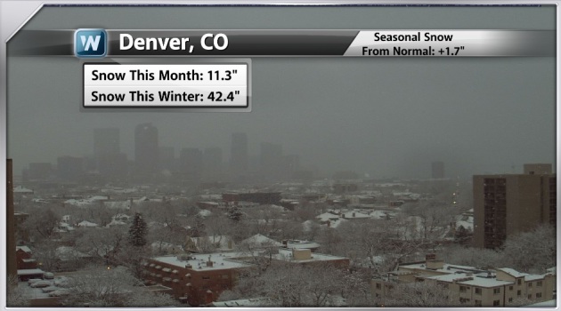
The WEBCAM from Denver, CO on Tuesday showed more snow falling across the area. This is after the larger storm that produced shovelable snow over the weekend. As of Monday, there had been 42.4" of snow for the season, which was nearly 2" above normal for the season! Seems surprising doesn't it?
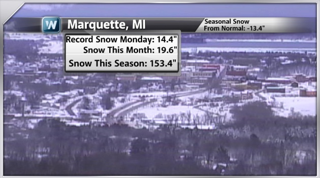
Record Snow in Marquette, MI
Monday also brought heavy snow to the U.P. of Michigan, in fact the 14.4" was a record for the day! Interestingly, Marquette is still nearly 12" below normal snowfall even with a seasonal snow tally over 150"!
We asked folks on Facebook if they could write a letter to Winter, what would you say... I thought some of the comments were pretty good! LOL!!


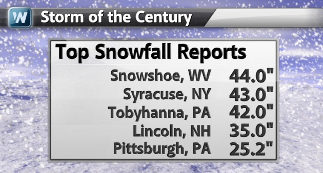
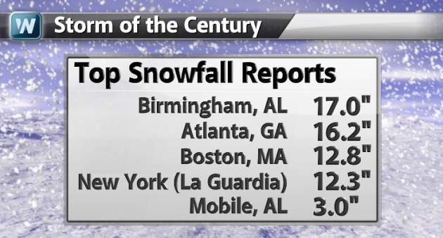
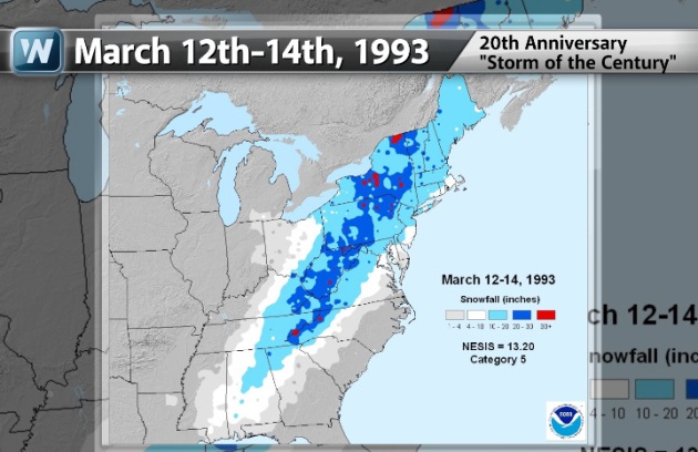
It's no surprise that the month of March can be a snowy month for some. Do you remember the "Storm of the Century" back in 1993? March 12th-14th, 1993 hauled in heavy snow from the Gulf Coast States to the New England Region. Take a look at some of the images below.


Impressive Snowfall Tallies!
Here are just a few of the impressive snowfall tallies, note the reports out of Alabama!
"The Storm of the Century, also known as the '93 Superstorm, or the (Great) Blizzard of 1993, was a large cyclonic storm that formed over the Gulf of Mexico on March 12, 1993, and dissipated in the North Atlantic Ocean on March 15. It is unique for its intensity, massive size and wide-reaching effect. At its height, the storm stretched from Canada towards Central America, but its main impact was on the Eastern United States and Cuba. The cyclone moved through the Gulf of Mexico, and then through the Eastern United States before moving into Canada. Areas as far south as central Alabama and Georgia received 6 to 8 inches (15 to 20 cm) of snow and areas such as Birmingham, Alabama, received up to 12 inches (30 cm) with isolated reports of 16 inches (41 cm). Even the Florida Panhandle reported up to 4 inches (10 cm),[2] with hurricane-force wind gusts and record low barometric pressures. Between Louisiana and Cuba, hurricane-force winds produced high storm surges across northwestern Florida, which along with scattered tornadoes killed dozens of people. Record cold temperatures were seen across portions of the South and East in the wake of this storm. In the United States, the storm was responsible for the loss of electric power to over 10 million customers. It is purported to have been directly experienced by nearly 40 percent of the country's population at that time.[3] A total of 310 people, including 10 from Cuba, perished during this storm."
Read more on the Storm of the Century HERE:
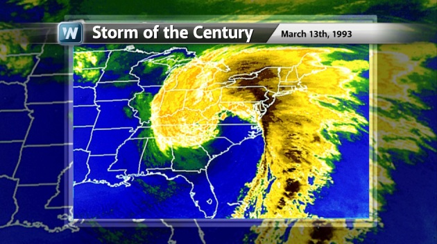
Satellite View of the Storm of the Century in 1993
I thought this was an impressive
picture... This was the satellite view of the storm as it was dumping
massive quantities of snow in the eastern U.S.
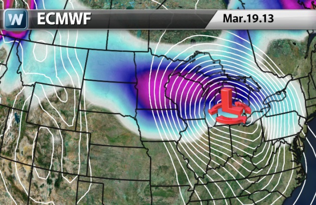
Additional March Snow?
Extended models are suggesting
the potential of 'something' developing next week across the Upper
Mississippi Valley/Great Lakes Region. It's still several days out and
I've noticed how inconsistent the models have been with the system so
far. Earlier this week, it had this same storm over the Northeast. It'll
be one to watch, but don't buy into what the extended models are
selling just yet.
Thanks for checking in, have a great rest of your week.
Don't forget to follow me on Twitter @TNelsonWNTV