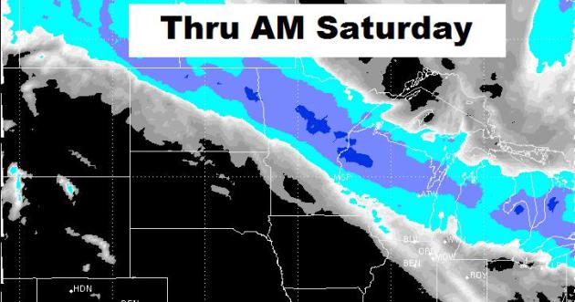
A quick moving clipper system will impact the area two different waves through the end of the week. The first punch will move through late Wednesday/early Thursday with a little wintry mix (including a little light freezing drizzle potential). The second and a little more substantial wave will move through Friday. The result will be some light shoveling duties for folks across central and northern MN and WI. On the southern edge of this snow, there will once again be a little freezing rain/drizzle potential. The graphic below suggests the snowfall potential thru AM Saturday.
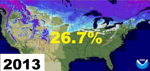
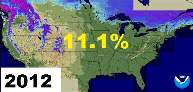
Snow Depth Comparison
Take a look at the National Snow Depth comparison from 2013 to 2012. Thanks to a remarkable warm March 2012, very little national snowpack was still visible. Winter is still hanging on this year and we may add to that snowpack yet into the coming days.
Remembering March 2012
I don't know about you, but I could go for a nice warm day right about now. Unfortunately, Mother Nature was a litte goofed up last year. Not only did we have a number of record high temperatures, but there were reports of magnolia trees in full bloom as well!

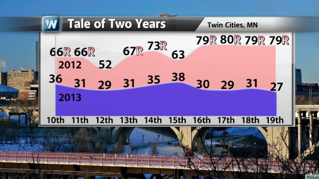
Twin Cities March 2012 Sample
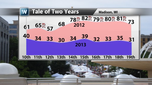
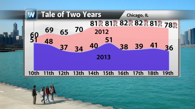
Here is just a sample of what we experienced last March. Look at the stretch of record highs! WOW!! The meteogram below shows temperatures in 2012 vs. 2013 (including 2013 forecast highs thru the 19th). All the numbers from 2012 with an "R" appended to it was a record for that date.
2012 March Madness in Madison, WI
Here's a sample of temperatures in Madison, WI.
2012 March Madness in Chicago, IL
Here's a sample of temperatures in Chicago, IL.
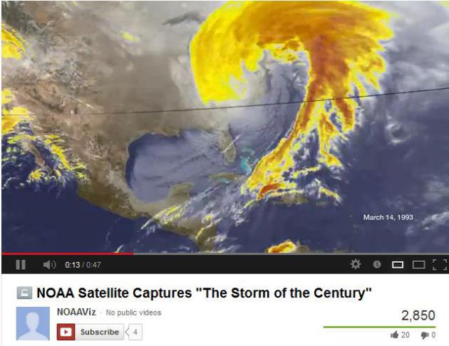
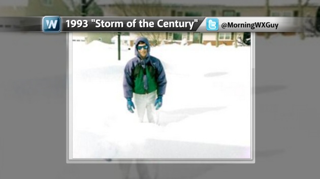
Remembering the 1993 "Storm of the Century"
From March 12th-14, 1993 - a massive winter storm wrapped up across the eastern part of the country with massive snow totals, exceeding 40" in some cases!
"What started out as an area of low pressure off the coast of Texas on March 12, 1993 quickly developed into what many people refer to as "The Storm of the Century." The evolution of this winter superstorm can be seen in this imagery from the GOES-7 satellite, using both visible and colorized infrared data. As the storm developed in the Deep South, it spawned 11 tornadoes in Florida and dumped from 8 to 33 inches of snow from Alabama to the Carolinas. As the storm moved north and intensified, conditions became even worse. With a central pressure of 960 millibars, usually found only in Category 2 hurricanes, whiteout conditions were common. Snowfall exceeded 3.5 feet in some locations.
When the storm passed, 208 people were dead and $6.6 billion dollars in damage were sustained. The National Climatic Data Center still ranks the 1993 as the most (www.ncdc.noaa.gov/snow-and-ice/rsi/nesis) impactful winter storm to hit the Northeast. Though the 1978 and 1996 blizzards may have brought more intense localized conditions, the scale of the 1996 storm has not been equaled in recent history."
See more from NOAAViz HERE:
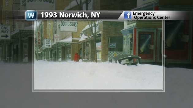
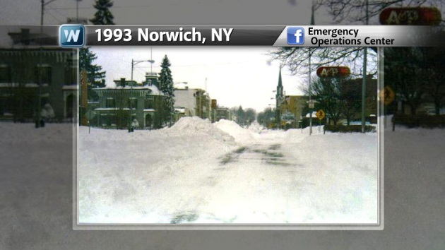
1993 Incredible Snowfall Tallies
There were some incredible snowfall tallies from that storm! A number of spots picked up over 30", but how about 16.2" from Atlanta, GA. Here are some images from the storm back then.
"Described as one of the largest and most intense storms in a century, the March 12-14,1993 blizzard paralyzed the eastern seaboard with record cold, snow, and wind. Southern cities not accustomed to severe winter weather like Birmingham, Alabama, Atlanta, Georgia, and Chattanooga, Tennessee were buried by paralyzing snows and frozen by unseasonable cold. The severe cold following the storm preserved much of the snow, prolonging travel nightmares for a couple days over the south where most roads were never plowed. The combined effects of high wind and heavy wet snow downed thousands of miles of power lines leaving millions of people in the dark for up to a week in some cases over the south. The above photo was taken right after the storm. Albany resident Dave O'Connor digs out his car on upper Madison Street."
Read more from cbs6albany.com HERE:
Are You Done With Winter?
We asked another question on Facebook wheather or not you're done with winter!? There were several good responses, here are a few.


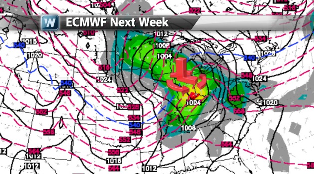
Winter Not Giving Up Just Yet?
Extended model runs are still hinting at yet a little more substantial snow event late weekend/early next week across parts of the Upper Mississippi Valley and Great Lakes Region. Consistency in the ECMWF (European model) has been fairly good in recent days, which is helping with the growing confidence level of this potential event. Stay tuned for further updates!
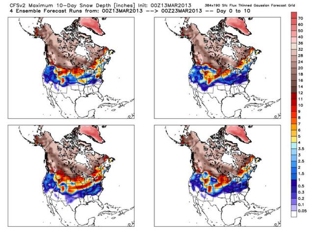
Long Range Maximum National Snow Depth Forecast
This is a little interesing.
Here's a long range (10-day) model forecast of possible maximum snow
depth across the nation. Note how far south this snow could be. Winter
may not just yet!
March 14th = "Pi Day"
Don't forget that March 14th = 3/14 is "Pi" day, which mathematically is 3.14! So, happy Pi Day!

Calculating Pi With Real Pies!
In honor of "Pi Day" - I thought this video was neat... Also note that the length of the video is 3mins and 14secs - LOL!
"How accurately can we calculate Pi using hundreds of REAL pies?"
See the full video HERE:

In honor of "Pi Day" - I thought this video was neat... Also note that the length of the video is 3mins and 14secs - LOL!
"How accurately can we calculate Pi using hundreds of REAL pies?"
See the full video HERE:
Thanks for checking in, have a great rest of your week!
Don't forget to follow me on Twitter @TNelsonWNTV