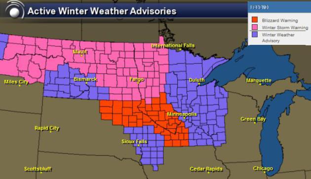
Winter's Last Gasp?
I sure hope so... Not sure how much of this
extended winter weather I can take. The cold, snow and extra long
commutes are wearing me thin! The National Weather Service continues a
number of winter weather headlines through Monday across the Upper
Midwest.
...BLIZZARD CONDITIONS LIKELY ACROSS WESTERN...SOUTHERN AND
PORTIONS OF CENTRAL MINNESOTA LATE TONIGHT INTO MONDAY EVENING...
.A LATE SEASON WINTER STORM WILL BRING A QUICK BURST OF 2 TOPORTIONS OF CENTRAL MINNESOTA LATE TONIGHT INTO MONDAY EVENING...
5 INCHES OF SNOW FROM LATE TONIGHT THROUGH EARLY MONDAY ACROSS
THE REGION. THIS STORM WILL DRIVE A POWERFUL COLD FRONT THROUGH
MINNESOTA AND WESTERN WISCONSIN BY MIDDAY MONDAY.
WEST TO NORTHWEST WINDS OF 30 TO 40 MPH...WITH GUSTS OF AROUND
50 MPH WILL FOLLOW BEHIND THE FRONT OVER WESTERN AND SOUTHERN
MINNESOTA...PERSISTING INTO EARLY MONDAY EVENING. THESE STRONG
WINDS WILL INTERACT WITH THE NEW SNOW AND CAUSE WHITE OUT
CONDITIONS SOUTH OF INTERSTATE 94 AND WEST OF INTERSTATE
35...INCLUDING CARVER AND SCOTT COUNTIES IN MINNESOTA. SLIGHTLY
LIGHTER WINDS AND MORE TREES SHOULD PRECLUDE BLIZZARD CONDITIONS
OVER FAR EASTERN MINNESOTA AND WESTERN WISCONSIN...INCLUDING
HENNEPIN AND RAMSEY COUNTIES AND THE REMAINDER OF THE TWIN CITIES
METRO.
+++++++++++++++++++++++++++++++++++++++++++++++++++++++++++++
Update on BLIZZARD WARNING:
...BLIZZARD WARNING IN EFFECT FROM 1 AM MONDAY TO 1 AM CDT TUESDAY...
THE NATIONAL WEATHER SERVICE IN TWIN CITIES/CHANHASSEN HAS ISSUED
A BLIZZARD WARNING...WHICH IS IN EFFECT FROM 1 AM MONDAY TO 1 AM
CDT TUESDAY. THE BLIZZARD WATCH IS NO LONGER IN EFFECT.
* WINDS/VISIBILITY: SUSTAINED WINDS OF 30 TO 40 MPH...WITH GUSTS
NEAR 50 MPH WILL CAUSE BLOWING AND DRIFTING SNOW AND NEAR ZERO
VISIBILITY IN OPEN AREAS.
* SNOW ACCUMULATIONS: 2 TO 4 INCHES.
* TIMING: SNOW WILL BEGIN LATE THIS EVENING AND TAPER OFF LATE
MONDAY MORNING. STRONG WINDS WILL THEN DEVELOP MONDAY MORNING
BEHIND A COLD FRONT BEFORE SUBSIDING MONDAY EVENING.
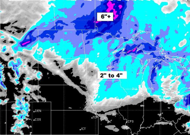
Timing the Snow...
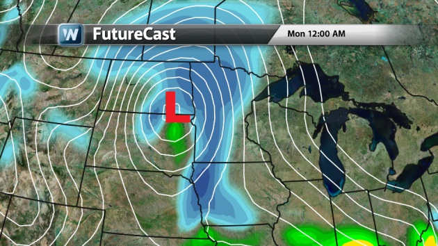
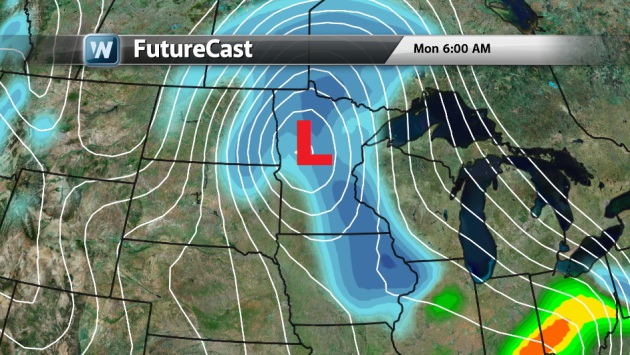
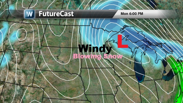
Snow Potential...
Here's a look at the snowfall potential through Tuesday.
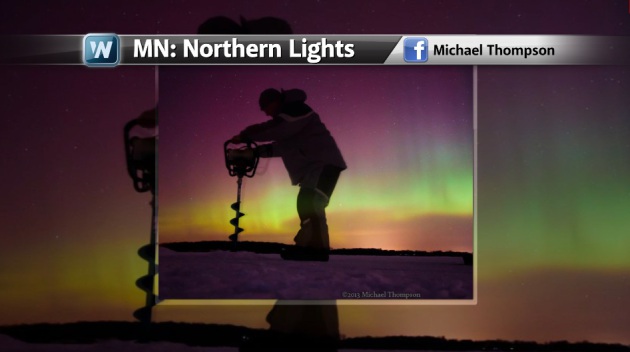
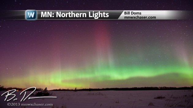
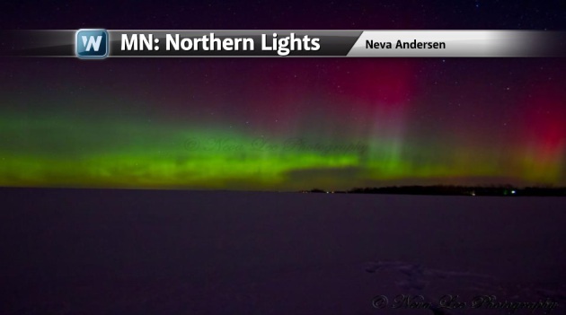
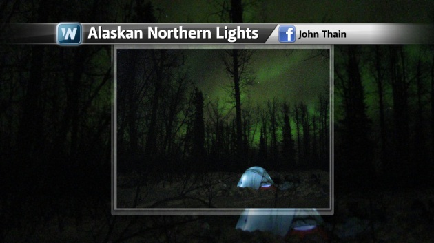
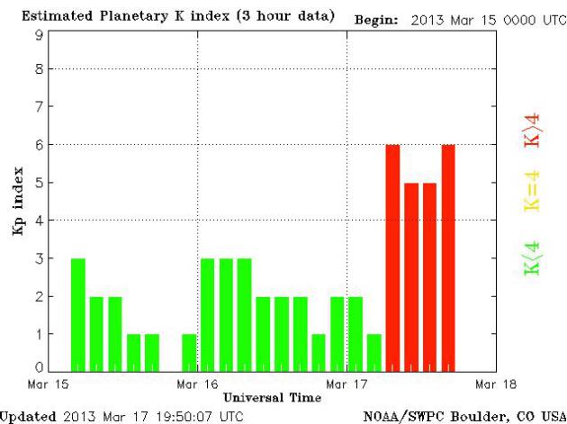
Northern Lights...
A very nice display of northern lights was visible Saturday night across parts of the northern latitudes. Here are a few of the more impressive images I saw! Thanks to Michael Thompson, Bill Doms, Neva Andersen and John Thain for the amazing images below!
Auroras Still Visible?
Dwellers in the northern latitudes (weather permitting) should still be on the look-out for more northern lights as the Geomagnetic Storming continues...
See the Planetary K-Index HERE:
Remembering March 2012...
I hate to pour salt in the wound, but can you believe that at this time last year, we were close to 80° in the Twin Cities? The official high was 79F on the 18th and 19th, both records highs. Nearly everything was off to an early start, even the magnolias were blooming!
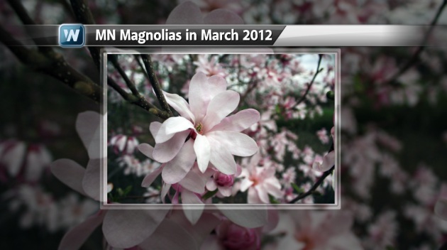
March 2012
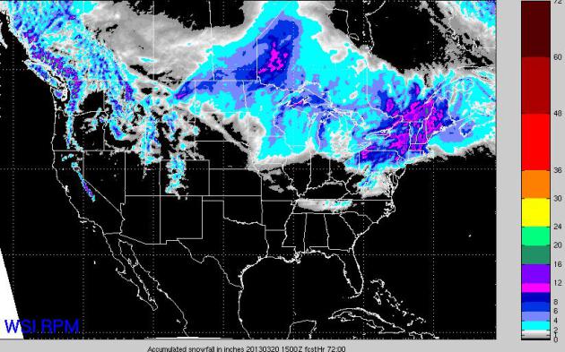
National Snowfall
National snowfall over the next 3
days could be quite heavy across parts of the northern tier of the
nation, especially the Midwest, Northeast and Northwest.
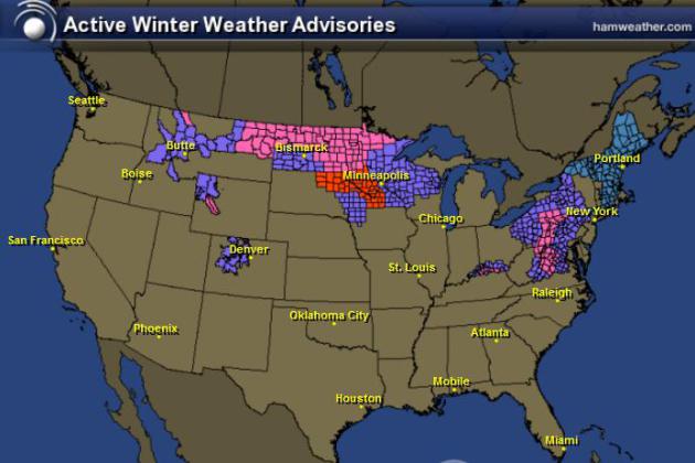
Winter Weather Headlines
The National Weather Service has
updated their winter weather headlines map to include folks in the
Northeast for the potential of heavy snowfall. Stay tuned for more!
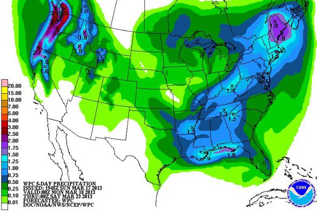
National Precipitation Forecast
NOAA's HPC 5 day precipiation
forecast suggests that several inches of precipitation could fall across
the eastern half of the country and also in the west.
Northern Lights...
A very nice display of northern lights was visible Saturday night across parts of the northern latitudes. Here are a few of the more impressive images I saw! Thanks to Michael Thompson, Bill Doms, Neva Andersen and John Thain for the amazing images below!
Auroras Still Visible?
Dwellers in the northern latitudes (weather permitting) should still be on the look-out for more northern lights as the Geomagnetic Storming continues...
See the Planetary K-Index HERE:
Remembering March 2012...
I hate to pour salt in the wound, but can you believe that at this time last year, we were close to 80° in the Twin Cities? The official high was 79F on the 18th and 19th, both records highs. Nearly everything was off to an early start, even the magnolias were blooming!
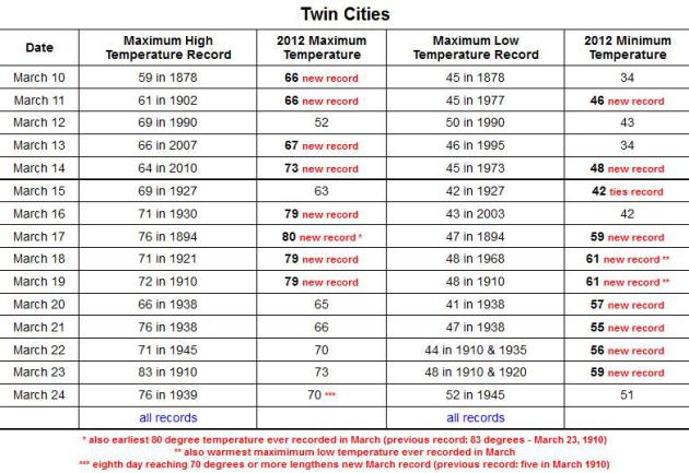
"Mother Nature is rearranging her trophy case. An unprecedented mid-March influx of warm, moist air has produced record-setting temperatures for many locations east of the Rockies, including Minnesota.
During this warm stretch, the maximum temperature in the Twin Cities has reached or exceeded 70 degrees on eight days, breaking the previous March record of five set in 1910. Through March 19, the Twin Cities maximum temperature reached or exceeded 70 degrees for four consecutive days, breaking the previous record of three consecutive days which occurred on March 23-25, 1939 and March 22-24, 1945.
When the Twin Cities temperature reached 80 dgrees on March 17, it was the first 80 degree temperature since October 9, 2011. The span without 80 degree temperatures was 159 days, the fewest consecutive number of days without 80 degrees in the modern record."
See more from Climate.umn.edu HERE:
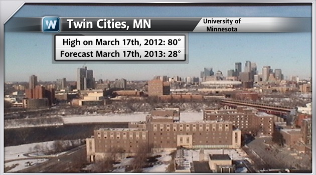
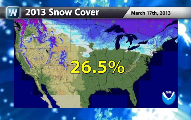
Big Swing in the Twin Cities
Look at how much different 2012 was vs. this year in the Twin Cities... WOW!
What A Difference... 2012 vs. 2013
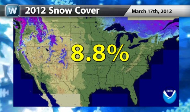
Take a look at how little snow cover was left across the nation on March 17th, 2012. Other than the higher elevations out west and those in the Northeast, it was nearly all gone! There is still nearly 27% snow cover across the nation this year!
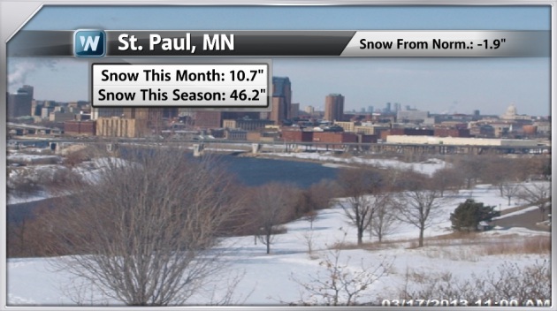
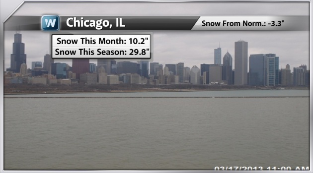
Snowy February and First half of March
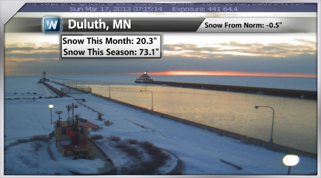
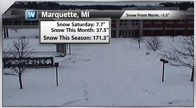
If it hadn't been as cold and snowy over the last month and a half, there would stil be some pretty big snow deficits across the northern tier of the country. Thanks to a more active weather patter over the last several weeks, several locations have been making up for lost time.
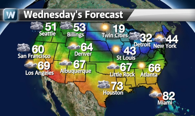
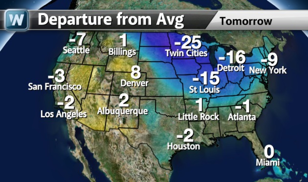
Spring Begins Wednesday
Although the calendar will say Spring, it'll feel more like Winter for folks in the northeast quadrant of the nation through much of the week. Below are high temperatures expected Wednesday with the departure from normal.

Thanks for checking in and have a great week ahead!
Don't forget to follow me on Twitter @TNelsonWNTV