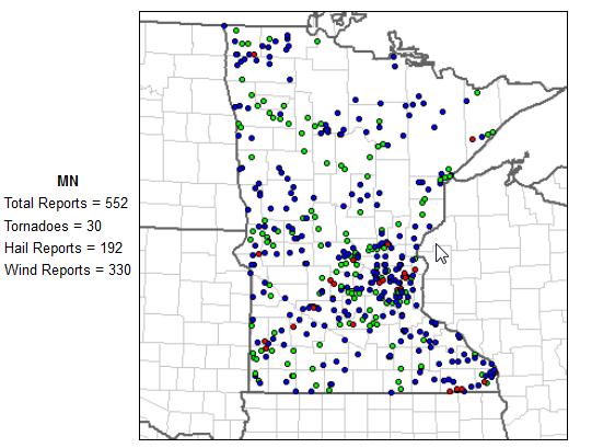
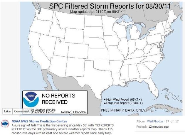
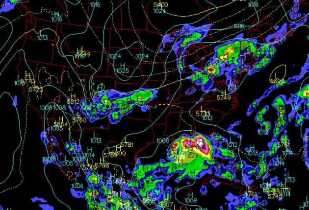
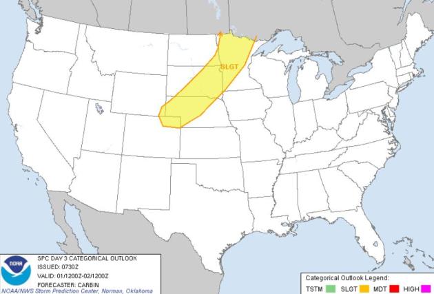
 Thursday Severe Risk
. An eastbound cool front may spark strong to severe storms from Minnesota into eastern South Dakota later today and tonight - a few storms capable of large hail and damaging winds. Source: SPC.
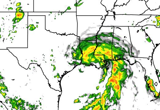
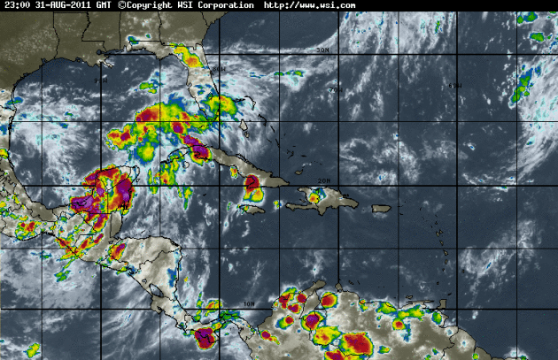
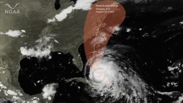
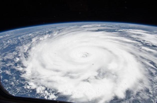
America's Next Tropical Storm? A tropical depression in the Gulf of Mexico is being closely monitored for intensification. Enhanced IR satellite loop courtesy of
intellicast.com. Here's the latest from NHC:
"A LARGE AREA OF DISORGANIZED CLOUDINESS AND THUNDERSTORMS OVER THE
SOUTHEASTERN GULF OF MEXICO IS ASSOCIATED WITH A TROUGH OF LOW
PRESSURE.  UPPER-LEVEL WINDS ARE CURRENTLY UNFAVORABLE FOR
DEVELOPMENT...BUT ARE FORECAST TO BECOME MORE CONDUCIVE ON
THURSDAY...AND THIS SYSTEM COULD BECOME A TROPICAL DEPRESSION
DURING THE NEXT DAY OR SO.  THIS SYSTEM HAS A HIGH CHANCE...60
PERCENT...OF BECOMING A TROPICAL CYCLONE DURING THE NEXT 48 HOURS
AS IT MOVES SLOWLY NORTHWESTWARD.  INTERESTS ALONG THE ENTIRE
NORTHERN GULF OF MEXICO COAST SHOULD MONITOR THE PROGRESS OF THIS
DISTURBANCE."
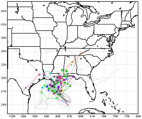
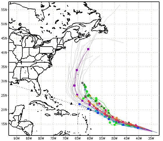
Tropical Storm Lee? Conditions are ripe for a tropical depression in the Gulf of Mexico to strengthen to at least tropical storm status, and then come ashore over coastal Louisiana or Mississippi, before pushing northeast across Georgia into the Carolinas early next week. As you can see from the jumbled path predictions - the specific track is still unclear, but residents of the Gulf Coast should stay alert.
 Solution 1: Landfall Over Louisiana.
 The NAM model brings "Lee" into coastal Louisiana and Mississippi late in the week. The map above is valid 7 pm Friday evening.
 Solution 2: Landfall over Texas?
 The WRF solution develops a strong tropical storm or possible hurricane in the western Gulf of Mexico later this week. The map above is valid 7 am Saturday morning, showing what appears to be a minimal hurricane (complete with eye) off the coast of Galveston. Yes, there is at least a slight chance of a drought-busting storm for Texas by the weekend.
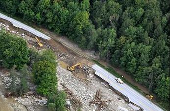
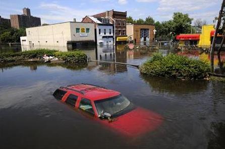
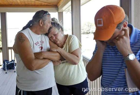
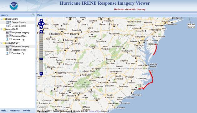
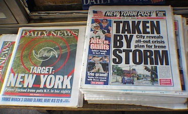
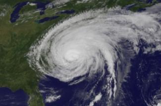
Hurricane Cost Seen Ranking Among Top Ten. The storm surge was bad enough, but inland flooding will probably be responsible for the vast majority of the damage from Irene; historic river flooding from the Delaware Valley and northern New Jersey to Vermont. The
New York Times has more details: "
Hurricane Irene will most likely prove to be one of the 10 costliest catastrophes in the nation’s history, and analysts said that much of the damage might not be covered by insurance because it was caused not by winds but by flooding, which is excluded from many standard policies. Industry estimates put the cost of the storm at $7 billion to $10 billion, largely because the hurricane pummeled an unusually wide area of the East Coast. Beyond deadly flooding that caused havoc in upstate New York and Vermont, the hurricane flooded cotton and tobacco crops in North Carolina, temporarily halted shellfish harvesting in Chesapeake Bay, sapped power and kept commuters from their jobs in the New York metropolitan area and pushed tourists off Atlantic beaches in the peak of summer."
- At least 44 deaths have been reported in 13 states and an estimated 2 million people remained without electrical power Wednesday.
- Vermont officials are making some headway trying to deliver supplies to flooded communities. One Vermont official is calling this the worst natural disaster in the state’s history.

- Roads were open to at least emergency vehicles across the state, though some communities including Stratton and Rochester were still barely accessible
- Federal emergency officials are scheduled to tour Upstate New York and New Jersey later in the day.
- In New Jersey, the Ramapo, Pompton and Passaic rivers crested and started to slowly recede, More than 10,000 evacuees were still waiting to return to their homes
- New York Gov. Andrew Cuomo’s office reported
- that power had been restored to about 78% of the areas that were hit by Irene.
- Early Wednesday, President Obama declared a major disaster in New York, freeing up federal recovery funds for people in eight counties. Governor Cuomo says damage in New York is likely to hit 1 billion.
- NJ TRANSIT restored rail service Wednesday morning on the Northeast Corridor from Trenton Transit Center to New York Penn Station.
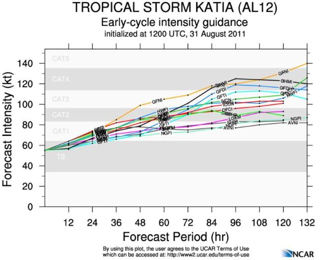
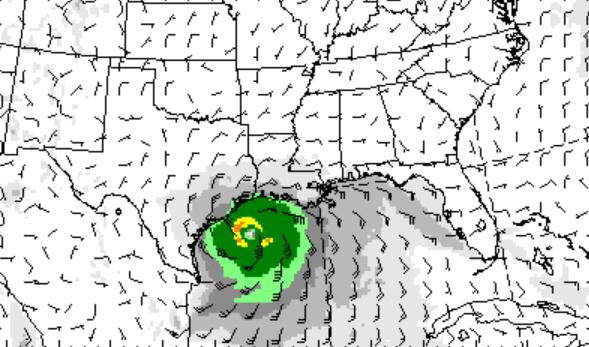
Check out the Tropical Cyclone Guidance Project (RAL), courtesy of
UCAR in Boulder, which shows model guidance strengthening Hurricane Katia into a Category 3 storm with sustained winds over 111 mph within 120 hours: "
The real-time guidance system generates an individual page for each active storm in the North Atlantic, Northeast Pacific, and North Central Pacific basins. Each individual storm page features the latest plots of model guidance and intensity forecast aids for that storm, as well as other diagnostic and observational information. For more information and about the real-time guidance system and the documentation for each section of the individual storm pages, click here."
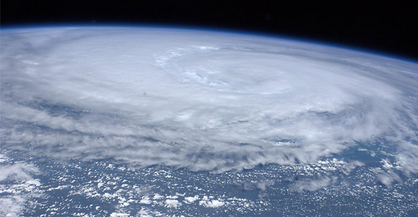
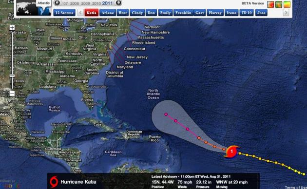
Katia: A Near Miss? Odds favor that Hurricane Katia will make a turn to the north/northeast, probably avoiding the east coast of the USA. Map courtesy of NHC and Ham Weather.
Projected Path For Katia. The hurricane should weaken as it passes over colder ocean water in the north Atlantic, possibly brushing the Canadian Maritimes as a tropical storm early next week.
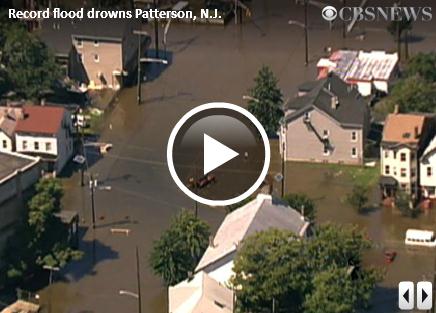
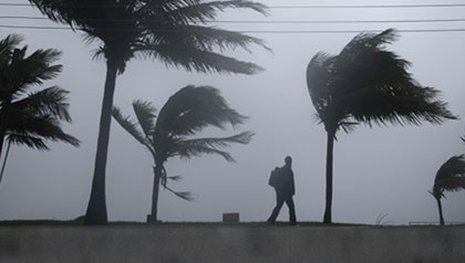
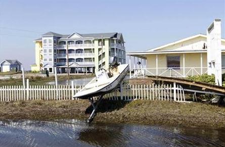
Flood Dangers From East Coast Face The East Coast. Here's an update from
The Huffington Post: "
NEWFANE, Vt. — As emergency airlift operations brought ready-to-eat meals and water to Vermont residents left isolated and desperate, states along the Eastern Seaboard continued to be battered by the after effects of Irene, the destructive hurricane turned tropical storm. Dangerously damaged infrastructure, 2.5 million people without power and thousands of water-logged homes and businesses continued to overshadow the lives of residents and officials from North Carolina through New England, where the storm has been blamed for at least 44 deaths in 13 states. Raging floodwaters continued to ravage parts of northern New Jersey on Wednesday morning, even after the state's rain-swollen rivers crested and slowly receded. The Passaic River crested Tuesday night, causing extensive flooding and forcing a round of evacuations and rescues in Paterson, the state's third-largest city. "Been in Paterson all my life, I'm 62 years old, and I've never seen anything like this," said resident Gloria Moses as she gathered with others at the edge of what used to be a network of streets, now covered by a lake. New Jersey Gov. Chris Christie, after touring Wayne, through which the Passaic also flows, said Tuesday night he saw "just extraordinary despair."
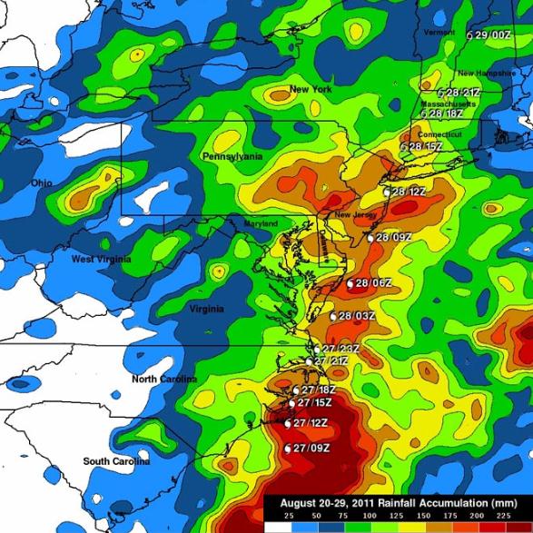
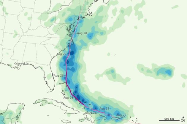
NASA Measures Irene's Record Rainfall Totals From Space. Some of the rainfall amounts (derived from satellite sensors) are staggering, as much as 225-250 millimaters).
WIRED.com has more details: "
NASA has totaled the impressive rainfall from Hurricane Irene using highly precise microwave measurements from a satellite. The map, created using data recorded by the Tropical Rainfall Measuring Mission (TRMM) satellite from Aug. 20-29, reveals rainfall in some bands of the now-dissipated 10-day-long storm exceeded 2 inches per hour. “Hurricane Irene was dropping tremendous amounts of rainfall over the eastern United States during a part of this period,” said TRMM team member Hal Pierce of NASA’s Goddard Space Flight Center in a press release. To gauge rainfall levels, the satellite relies on an instrument that measures microwave radiation. Flat water looks cold because of it doesn’t emit microwave radiation as readily, but round raindrops falling from clouds do and appear warm. By running calculations of the cold/warm contrast over oceans, TRMM can accurately assess rainfall totals. Over land the situation is trickier. Soil, plants and other materials on the ground emit microwave radiation almost as efficiently as water droplets, providing poor contrast to detect rainfall. But ice crystals present at the tops of most rain-making clouds are different enough in microwave-detected temperatures to allow the satellite to infer rainfall intensity and levels."
Rainfall Amounts From Irene:
- Virginia Beach Va., 20.40 inches
- Jacksonville, N.C., 20.00 inches
- Bunyan, N.C., 15.66 inches
- New Bern, N.C., 14.79 inches
- Williamstown, N.C., 14.27 inches
- Leonardtown, Md., 13.35 inches
- East Durham, N.Y., 13.30 inches
- Washington, N.C., 13.11 inches
- Plum Point, Md., 12.96 inches
- Ft. Eustis, Va., 12.52 inches
Wind Gusts From Irene:
- Mt. Washington, N.H., 120 mph
- Cedar Island, N.C., 115 mph
- Fort Macon, N.C., 92 mph
- Sayville, N.Y., 91 mph
- Hatteras, N.C., 88 mph
- Conimicut, R.I., 83 mph
- Barrington, R.I., 82 mph
- Buxton, N.C., 79 mph
- Soyosset Mobile, N.Y., 79 mph
- Cape Lookout, N.C., 78 mph
* information courtesy of
EverythingWX.
New Jersey Governor Chris Christie Finds Despair In Flood Zone Tour. Here's a story from the
Boston Herald and CBS News: "
TRENTON, N.J. – New Jersey Gov. Chris Christie ordered the gates of the Pompton Lake Dam to be opened nine hours before Hurricane Irene arrived – dropping the water level by 3 feet – hoping to avoid what turned out to be inevitable. In previous floods, officials had kept the gates shut, and flooding occurred. Christie said he didn’t know if his actions had any effect and would wait until an independent review of the dam is completed in February before judging the dam’s role in recent floods. The Army Corps of Engineers installed floodgates in 2007 as part of a project to reduce flooding. "I don’t believe the Army Corps of Engineers did anything up there that was trying to intentionally hurt people or make matters worse," Christie said. "But you learn in life that sometimes people make mistakes."
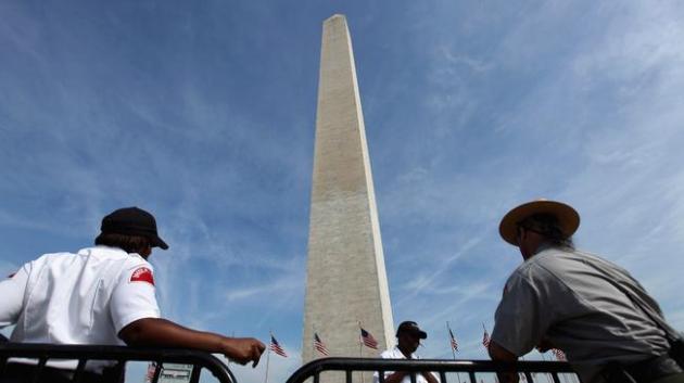
Washington Monument Leaking After Irene. The details from
NBC Washington: "
Walking into the Washington Monument on Monday after Hurricane Irene blew through, standing water was found puddled inside the iconic structure's interior. That water could indicate more cracks in the monument than were previously detected, Park Service spokesperson Carol Johnson told News4. An outside engineering has been working with the Park Service to evaluate breaks in the marble structure's upper triangle, detected after a 5.8 magnitude earthquake shook the nation's capital on August 23. A helicopter inspection following the quake revealed a 4-inch crack on one of the monument's upper triangular faces last week. A follow-up evaluation conducted by architectural firm Wiss, Janney, Elsner Associates detected at least 3 more large cracks in the monument."
Photo credit above: "
WASHINGTON, DC - AUGUST 24: Security guards and a U.S. Park ranger stand on the temporary fence circling the base of the Washington Monument on the National Mall August 24, 2011 in Washington, DC. The Washington Monument will remain indefinitely closed after Tuesday's 5.8 magnitude East Coast earthquake left cracks near the top of the 555-foot-tall obelisk." (Photo by Chip Somodevilla/Getty Images)
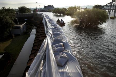
FEMA Chief To Tour Flood-Ravaged New Jersey; Looting Reported. An update from
NBC New York: "
Raging floodwaters continued to ravage parts of northern New Jersey as the nation's top emergency management officials Wednesday planned to view the damage left by Hurricane Irene. Flooding continued to besiege Paterson, Little Falls and Montville Township even after the state's rain-swollen rivers crested and slowly receded. Homeland Security Secretary Janet Napolitano and Federal Emergency Management Agency Administrator Craig Fugate planned to visit flood-damaged Lincoln Park, in Morris County, late Wednesday afternoon. The raging Passaic River crested Tuesday, bringing a new round of evacuations and more misery in places like Lodi and Paterson, where the first incident of looting was reported Wednesday. A resident identifying herself only as Jackie told NBC New York that a pack of as many as 20 or 30 youths jumped a fence into a backyard and tried to break into the rear of several homes that occupants had been forced to flee by the rising waters of the Passaic River."
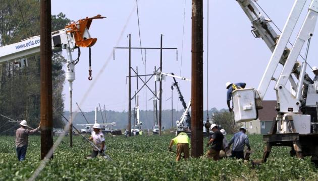
About Two-Thirds Of Irene Power Outages Are Fixed. The story from
AP: "
NEW YORK (AP) — Neighborhood by neighborhood, the lights are kicking back on. Utilities reported significant progress Tuesday on widespread power outages that followed Hurricane Irene. About 73 percent of the weekend's 9.4 million outages have been restored, according to an Associated Press tally. Thousands of repair crews are still working through a tangle of uprooted trees and floodwaters in 13 states that were raked by Irene over the weekend. The storm ripped out power lines, flooded electrical substations and crushed critical circuits that each bring power to thousands of people. Irene led to the deaths of at least 38 people in 11 states. Entire communities are still waiting for power. Eastham, Mass., on Cape Cod is still mostly in the dark. In Wakefield, N.H., 70 percent of the town's customers are off the grid. And nearly half of the 491,000 homes and businesses in the Richmond, Va., metro area are blacked out. Power companies say their first priority is to reconnect hospitals, police stations, emergency call centers and other critical services. After that they'll try to get schools back online in time for the fall semester. Individual neighborhoods and homes will be next on the list."
Photo credit above: "
About 85 Progress Energy workers work in the field in Alliance, N.C. trying to restore the power in the region east of New Bern, N.C. Monday, Aug.29, 2011. Thousands were still without power in eastern North Carolina in the wake of Hurricane Irene." (AP Photo/The News & Observer, Takaaki Iwabu)
Irene Strengthens Case For Natural Catastrophe Fund. Here's an Op-Ed from
Tampa Bay Online: "
If the devastation caused by tornadoes and floods over the past year weren't enough to convince skeptical states and governors of the need for a national catastrophe fund, Hurricane Irene should be the catalyst. The storm, which missed Florida but struck North Carolina and then slowly hit the rest of the East Coast, caused widespread havoc. At least 40 people have died, and damage from flooding — especially inland — and other effects is expected to tally well into the billions of dollars. In all likelihood residents of impacted areas will soon feel what Floridians have felt many times — the sting of higher property-insurance rates from hurricanes. A national "cat" fund would help soften future blows from those and other disasters by spreading risk throughout the country, instead of leaving individual states to fend for themselves. No region is immune from natural disasters. For example, as the people of especially hard-hit Vermont now know, tropical cyclones do not strike just Florida, Louisiana and the other Southeastern coastal states. And earthquakes are not limited to California, as many Virginia residents also learned last week. A national cat fund isn't a new concept. It would be funded by a portion of property insurance premiums already collected by companies and be allowed to grow tax-free. Officials would establish a damage "threshold," and the fund could not be tapped unless the threshold is exceeded."
Special Report: Hurricane Irene Wallops Flood Insurance Program. The details from
Reuters: "
The only thing worse than getting flooded out of your home once is getting flooded out of it twice. Or, for that matter, over and over again. Margaret Wert bought her Wayne, New Jersey house in 1999, relying on assurances from her realtor that any occasional flooding would only amount to an inch or two of water. A week after closing, Hurricane Floyd put four feet of water in her basement. Earlier this year, Wert, 45, got flooded again and received a payout of $5,000 on her government flood insurance, which costs her $1,200 a year. It wasn't enough to cover her bills, but it helped with the new stove, refrigerator and boiler. But all of Margaret Wert's new appliances and much of her house are now ruined, after Hurricane Irene flooded broad swathes of New Jersey. This time, though, she has a message for the government insurance program. "If they don't buy me out and give me what I want, I am going to walk away, and they can keep it. I will tell the insurance company 'give the check to the bank.' You can do the repairs. You can live there in mold, you can live there in smell, I am done."
Insurers Escape Irene's Wrath, Economy Does Not. The story from
Reuters: "
Hurricane Irene may heap billions of dollars of extra costs on the already fragile U.S. economy, but insurance companies are likely to emerge relatively unscathed. Most of Irene's damage was from flooding, which the government insures, instead of wind, which insurance companies cover, meaning insurers could pay out as little as $1.5 billion by some early estimates. That's just a fraction of the $10 billion to $12 billion of economic damage that Irene likely caused, according to estimates from catastrophe modelers and ratings agencies. Moody's Analytics said the storm might take a tenth of a percentage point off third-quarter gross domestic product.The question now for insurers is whether the insured losses are bad enough to eat up third-quarter earnings, which some analysts believe is the case, and whether the losses are enough to let insurers raise rates, which many analysts doubt."
Second-Guessing Irene: Could 120 Petabyte Array Make Better Predictions? Supercomputers have come a long way - but would an even more powerful weather model make a difference predicting track and intensity?
GCN.com has the details: "
Predicting the outcome of severe storms is one of the hardest jobs there is, based on complex models with many variables. The difficulty was evident with Hurricane Irene, which wound up being less severe than forecasters predicted. Perhaps the weak point isn’t computing power or human oversight. Perhaps it’s simply storage. The amount of data storage needed to run the sorts of simulations necessary to help predict weather patterns is, quite simply, really huge. Certainly it’s larger by degrees of magnitude than is currently needed for a desktop computer application or even basic storage for an entire network. IBM researchers have announced that that they are now able to link more drives together than ever before – 200,000 to be precise – into one giant continuous drive. Individually, these drives are just your ordinary serial-attached small computer system interface (SCSI) drives, but when IBM puts them together they yield 120 petabytes of storage. If you haven’t been working with long-term, back-up storage, you might not be familiar with that prefix. Well, you know what a gigabyte is — your desktop’s hard drive and even your key drives are likely quantified in this unit. A petabyte is more than 1 million gigabytes (actually, 1,048,576 – binary, remember?). That’s right – there are as many gigabytes in a petabyte as are there are kilobytes in a gigabyte." (photo credit:
datacenterknowledge.com).
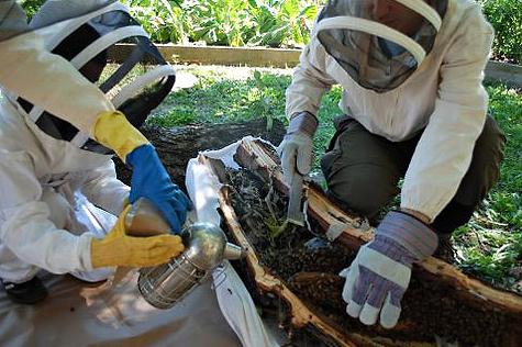
Forecast: Bees! Irene is gone, but in the hurricane's wake an infestation of bees have swept across portions of metro New York City. The
New York Times has more details: "
Tropical Storm Irene moved through New York City on Sunday knocking out power, causing flooding in some neighborhoods and knocking over many trees. In one corner of Fort Greene Park in Brooklyn, the storm also set off a fight — over bees. In a gale wind from the storm, a hollowed-out branch of an enormous tree was ripped off, exposing a hive of 30,000 to 40,000 honeybees. The hive’s discovery was a jackpot for the beekeeping community and word spread quickly on Facebook and Twitter that a feral hive was up for grabs. Two beekeepers jumped at the chance to claim the bees, unknowingly setting off a feud between two of the city’s main beekeeping groups."
Photo credit above: "
Lane Ramsey, 7, Ms. Dory’s son and John Derow, a beekeping student, extracted a bee hive from a hollowed out log at the Hart to Hart Community Garden in Bedford-Stuyvesant on Monday." (Liz Dory).
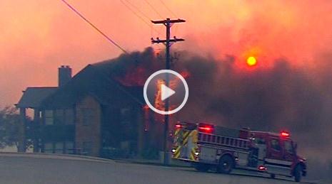
30 Homes Destroyed In Palo Pinto Wildfire. Extreme heat and drought across Texas is resulting in raging wildfires; this update from
WFAA-TV:
A fast-moving wildfire destroyed at least 30 homes and was threatening well over 100 more near Possum Kingdom Lake, forcing evacuations of several neighborhoods and dozens of children from a YMCA camp, officials said.
11:15am At a press conference held by Palo Pinto County Sheriff Ira Mercer 5,130 acres have burned in the wildfires that started on Tuesday. He is reporting that 25-30 homes have been destroyed. For those who have lost thier homes or forced to evacuate, the Red Cross has set up a shelter at First Baptist Church. There is concern about the weather leading into the early afternoon between 1 p.m. and 2 p.m. If the humidity drops and the wind picks up and it gets drier, the sheriff said they may be in more trouble."
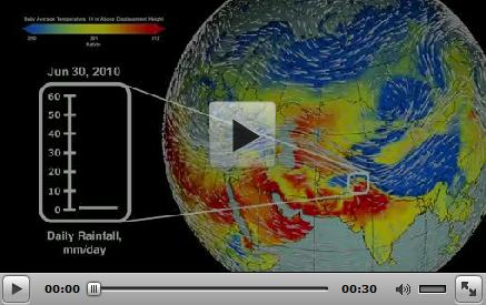
Extreme 2010 Russian Fires And Pakistan Floods Linked Meteorologically. Here's a fascinating story from
NASA: "
GREENBELT, Md. -- Two of the most destructive natural disasters of 2010 were closely linked by a single meteorological event, even though they occurred 1,500 miles (2,414 km) apart and were of completely different natures, a new NASA study suggests. The research finds that the same large-scale meteorological event — an abnormal Rossby wave — sparked extreme heat and persistent wildfires in Russia as well as unusual downstream wind patterns that shifted rainfall in the Indian monsoon region and fueled heavy flooding in Pakistan. Although the heat wave started before the floods, both events attained maximum strength at approximately the same time, the researchers found by analyzing satellite data generated by NASA instruments capable of measuring the land surface temperature, precipitation intensity and wildfire activity."
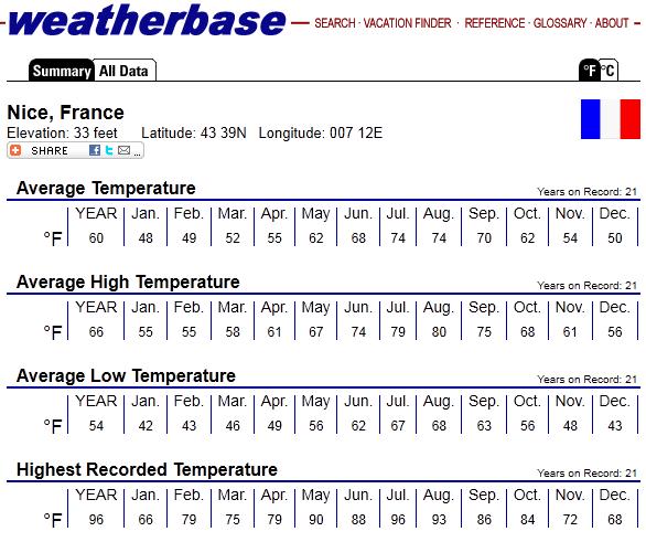
Planning A Trip Overseas? Interested in what the weather will be for a trip to Europe, the Caribbean, Asia - anywhere? Here's a good place to start:
weatherbase.com. This has average highs, lows and precipitation for every significant town on Earth - there's no way to predict specific (daily) weather beyond 10-12 days, but by looking at the averages you can get some sense of what to expect.
Jupiter-Bound Space Probe Captures Earth And Moon. I've never felt so small in my entire life.
NASA has the story: "
PASADENA, Calif. – On its way to the biggest planet in the solar system -- Jupiter, NASA's Juno spacecraft took time to capture its home planet and its natural satellite -- the moon. "This is a remarkable sight people get to see all too rarely," said Scott Bolton, Juno principal investigator from the Southwest Research Institute in San Antonio. "This view of our planet shows how Earth looks from the outside, illustrating a special perspective of our role and place in the universe. We see a humbling yet beautiful view of ourselves." The image was taken by the spacecraft’s camera, JunoCam, on Aug. 26 when the spacecraft was about 6 million miles (9.66 million kilometers) away. The image was taken as part of the mission team’s checkout of the Juno spacecraft. The team is conducting its initial detailed checks on the spacecraft’s instruments and subsystems after its launch on Aug. 5. Juno covered the distance from Earth to the moon (about 250,000 miles or 402,000 kilometers) in less than one day's time. It will take the spacecraft another five years and 1,740 million miles (2,800 million kilometers) to complete the journey to Jupiter. The spacecraft will orbit the planet's poles 33 times and use its eight science instruments to probe beneath the gas giant's obscuring cloud cover to learn more about its origins, structure, atmosphere and magnetosphere, and look for a potential solid planetary core."
Card courtesy of
somecards.com. Yep, that pretty much sums up America's summer.

Growing Risk of Tropical Storm "Lee"
The media may have over-hyped the storm surge in New York Harbor, but the potential for catastrophic, historic, INLAND flooding, was probably underestimated - in 20/20 hindsight. It's dangerous to think "Hmm...Category 1...tropical storm? No big deal." Tropical storms can be deadlier than hurricanes, especially when tropical moisture meets terrain; mountains can wring out 3-6 month's worth of rain virtually overnight.
A tropical storm (Agnes) got me interested in weather back in '72. It stalled over my home in Pennsylvania: 15" rain - I vividly remember swimming in my basement.
Irene will probably wind up being one of the top 10 costliest weather disasters in U.S. history; estimates range from $7-12 billion. "Katia" should avoid the east coast early next week, but a disturbance in the Gulf of Mexico may strengthen into T.S. "Lee". Models bring it into the Florida panhandle, stalling over New Jersey by the middle of next week. I'm hoping the GFS model is out to lunch.
Climate Stories...
Why Anti-Science Ideology Is Bad For America. An Op-Ed from climate scientist Peter Gleick at
Forbes.com: "
Anti-science ideology isn’t completely new in the U.S. — there is a dismaying history of irrational, pseudoscientific, or downright anti-scientific thinking and political culture here. But it seems to be gaining momentum — even as it runs counter to America’s scientific and technological strengths. Such strengths, in fact, underpin our economic and political strengths. I’m not talking about honest scientific skepticism and questioning – indeed, that is the very basis of good science. I’m talking about a disturbing combination of two factors: political cowardice hiding behind scientific skepticism; and political pandering to special interests by rejecting science, knowledge, and reason in favor of ideology, religion, or narrow economic self-interest. Sadly and with few brave exceptions, some politicians are active and aggressive at using false, misleading, or discredited science, or explicitly ignoring good science, in setting public policy to support ideology. History tells us this never leads to a good outcome. The Soviets let Lysenkoist ideology pollute their biological and genetic sciences in the 1930s, and they’ve never recovered. We saw it with the long, successful effort of the tobacco industry and their allies to confuse the public and delay regulations to protect public health, leading to millions of unnecessary cancer deaths. We saw it with the veto by Richard Nixon of the Clean Water Act (overridden with the help of some brave and influential Republican senators). And we see it now, in full flower, on the issue of climate change."
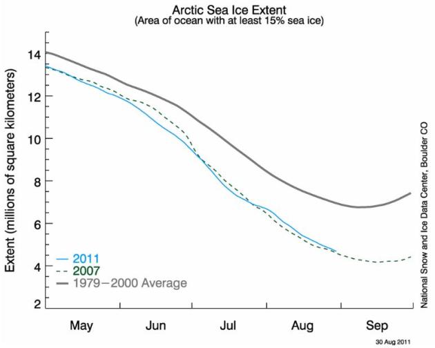
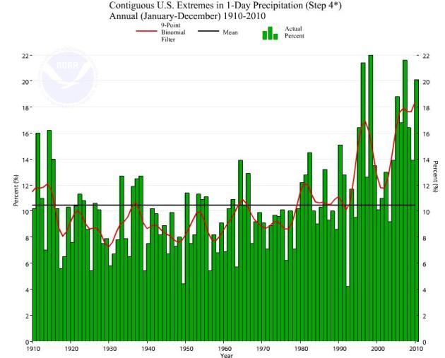
Near-Record Thinning Of Arctic Ice. We're approaching levels of ice not seen since the record summer of 2007. Data courtesy of the National Snow and Ice Data Center out in Boulder, Colorado.
Bill Nye: Hurricane Irene Evidence of Climate Change. I think it's dangerous to link any one storm with climate change. Some climate scientists argue that Gulf Stream water temperatures off the east coast were running 1-3 degrees F. warmer than average - which may have added additional fuel and moisture to Irene. Here is a story from
CBS News: "
We tend to avoid outright politics here on SmartPlanet, but Bill Nye -- known as "The Science Guy" after his popular television show on PBS -- recently visited the Fox Business channel's Freedom Watch to explain to host Charles Payne and his viewers the intricacies of drawing a line between Irene's destruction and climate change as a whole. The conversation, while expectedly argumentative at times, was interesting if only because Nye took great pains to simplify the science in a way that's understandable to the layman. For example, his first response to Payne's question of whether Irene was proof of global warming:
"I don't think the word "proof" is what you're looking for. "Evidence," or "a result of"? Yeah. Yeah. Now here's what the people will tell you who run these climate models. Now everybody, the word "model" in this usage is a computer program, a very sophisticated computer program. So you take data from satellites about the thickness of clouds and the extent of cloud cover over the sea. You take data about the temperature of the sea surface. You take data about the existing weather in let's say, North America or the Gulf of Mexico, as the storm moves into it, then you compute how much rain fell out of it, how much energy must have been put into it to create that much rain and it takes many months to analyze an event like Irene. Now, climate colleagues that I have will tell you that they cannot tell you today that Irene is evidence or a result of climate change, but check in with them in about March, next year, after they have a few months to collect all these millions and millions of data from weather services and satellites and compile them and run a climate model and show that Irene was a result of the world having more energy in its atmosphere."
Again, we need to be very cautious about connecting the dots, and linking any one meteorological event, no matter how catastrophic, to larger forces. The science is still unclear about whether a slowly warming atmosphere (and ocean) is resulting in more numerous or extreme hurricanes - more research is needed to make a clear connection between hurricane intensity and climate change. The
Environment News Service has the story:
"MONTPELIER, Vermont, August 30, 2011 (ENS) - At least 24 people have died across eight states as a result of Hurricane Irene, according to emergency officials. After first making landfall in North Carolina on Saturday, August 27, Irene had decreased to tropical storm force by the time it reached Vermont late on Sunday. Nevertheless, the impact was devastating. Three people in Vermont lost their lives, nearly 300 roads and 30 bridges are closed, rail traffic has stopped and the state office complex was shut down. U.S. Senator Bernie Sanders of Vermont told reporters, "There are some who believe that this is the worst natural disaster to hit the state since the 1927 floods."
The Political Lessons Of Hurricane Irene. Here's an Op-Ed from The
Des Moines Register: "
Hurricane Irene is a great case study of the idea that big government is our enemy. The 2012 election is all about big government, and Texas Gov. Rick Perry has said that if elected president he hopes to make the federal government “irrelevant” to average Americans. If climate change (regardless of how much is natural and how much is caused by human activity) is progressing as we assume, coastal areas may see repeat storms such as Irene. Therefore, we need to plan long range (not just respond to an incident such as a hurricane).
Irene is an opportunity to assess a range of political and policy issues.
We know from many studies that coastal areas have sensitive “critical infrastructure” including airports, railroad tracks, power plants, subways and tunnels, fuel and chemical storage facilities, ports, sewage treatment plants and military bases. These become extremely vulnerable when a huge storm hits the East Coast of the United States. The West Coast is somewhat different, but substitute tsunami for hurricane."


