Low Expectations
"Keep your expectations low. That way you may be pleasantly surprised from time to time."
Good
advice, especially for a meteorologist. Especially this "spring".
Goldilocks had a point: rarely is our weather "just right". It's usually
too hot-cold-wet-dry. The 7-Day Outlook should come with a 7-Day supply
of Zoloft.
But here's what I've discovered: the weather has an
uncanny way of evening things out. It may not happen next week or next
month, but this cold, foul, puddle-infested FAIL of a spring will be
balanced by an extended spell of gloriously lukewarm blue-sky
postcard-worthy days.
Then again I have been standing way too close to the Doppler.
Any
unwanted slush in your yard gives way to rain showers today as
temperatures aloft begin to mellow. Puddles shrink tomorrow as skies
brighten; 50s will feel like sweet relief this weekend as the sun makes a
rare cameo appearance. Next week will feel like spring again;
consistent 60s and even a few low 70s by the second week of May.
Like a cruel meteorological mirage spring keeps getting pushed back.
And
as much as I'm rooting for warm fronts to reach our lofty latitude, my
hope is that we have a quiet tornado year in Minnesota. Stay tuned.
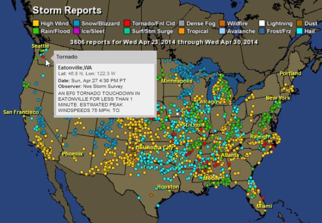
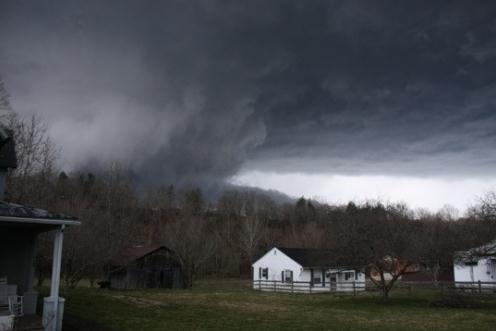
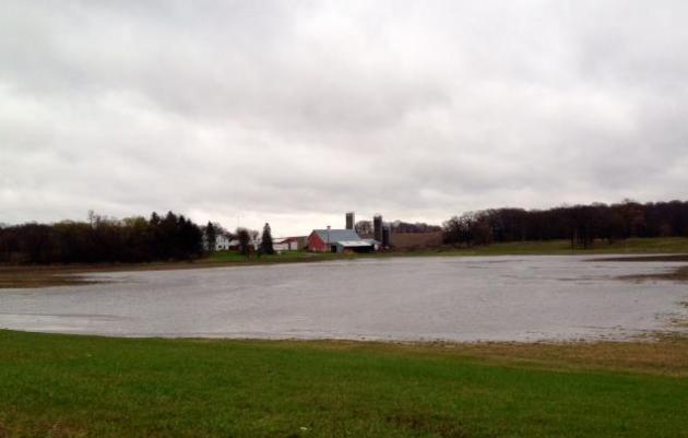
* photograph of a new lake in a farmer's field near Cologne, Minnesota courtesy of WeatherNation meteorologist Bryan Karrick.
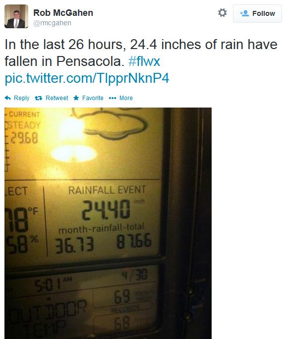
** Second wettest April on record in the Twin Cities. The Star Tribune has
details. More data from NOAA
here.
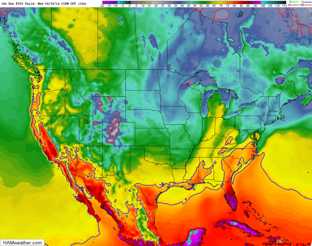
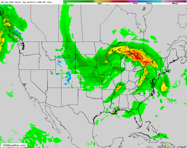
Unstuck.
The stormy pinwheel of moisture that has stalled out over the Ohio
Valley much of this week, sparking tornado outbreaks in the south and
soaking rains from the Ohio Valley and Great Lakes into the Upper
MIdwest, will finally get kicked out to sea by late week. Another
clipper-like system may push a few scattered instability showers into
Minnesota on Friday. NAM Future Radar: NOAA and HAMweather.
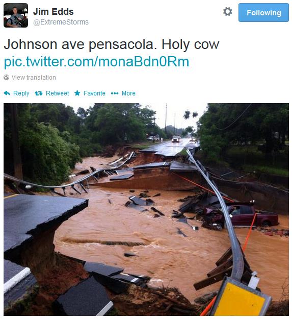
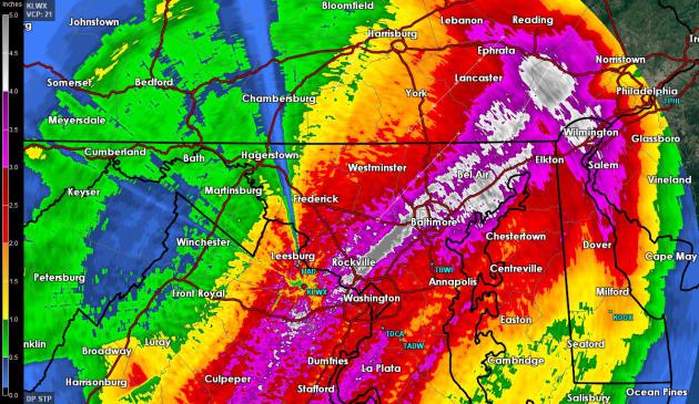
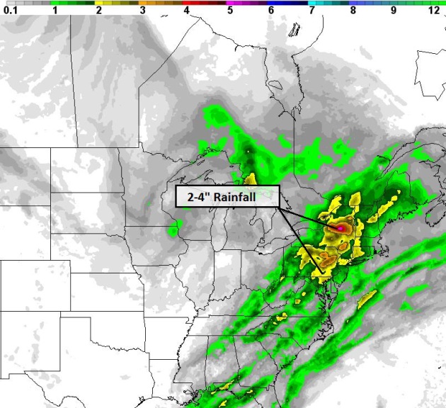
East Coast Soaking.
Some 2-3"+ rainfall amounts are likely from Washington D.C. to Albany
today and early Thursday, capable of minor flooding problems over the
Mid Atlantic and New England. Data: 84 hour NAM model, courtesy of NOAA
and HAMweather.
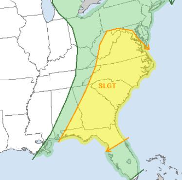
Severe Threat Lingers - Not As Extreme.
I'm happy to see a lack of "Moderate Risk" from NOAA SPC, a slight risk
from Washington D.C. to Charlotte, Atlanta and Orlando later today with
hail, straight-line winds and a few isolated tornadoes possible.
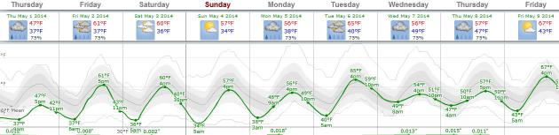
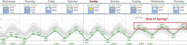
Another Springy Mirage?
Probably not. The ECMWF model is fairly consistent pulling 60-degree
air back into Minnesota next week. You may even be able to lose the
jacket for a couple of days. Today will be raw, but spring returns in
all it's glory by Tuesday. Graphic: Weatherspark.
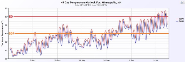
Cheering On The 45-Day Wish-Cast.
Confidence levels remain low on details, but the sun is climbing higher
in the sky; at some point it WILL warm up. NOAA's 45-day CFS (Climate
Forecast System) trend shows fairly consistent 60s in May, with 80s
surging into Minnesota in June. Better late than never. Source:
HAMweather.
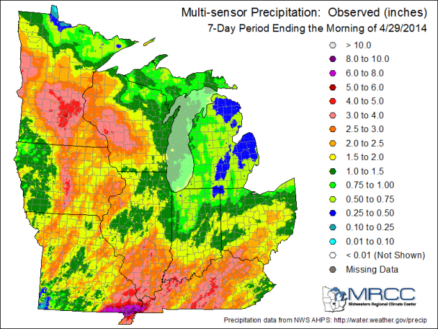
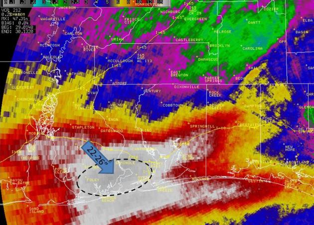
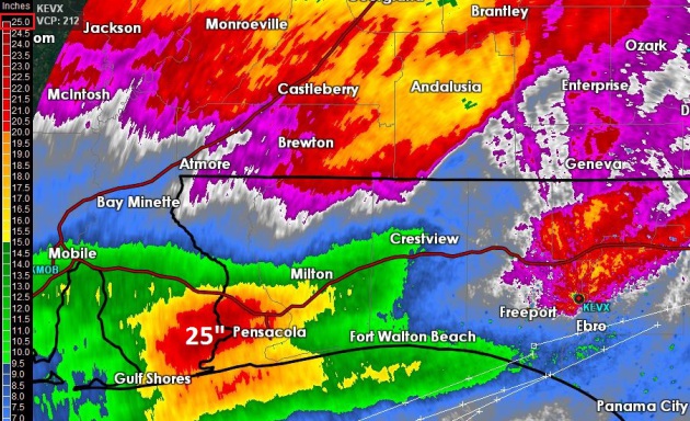
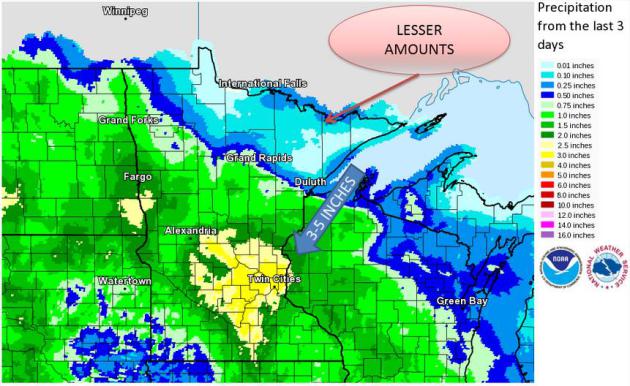
72 Hour Rainfall Amounts.
Most parts of the Twin Cities metro just picked up an April's worth of
rain since Saturday. Check out some of the amounts, courtesy of the
Twin Cities National Weather Service:
| Location | County, ST |
|
| Provider | 72 Hr Pcpn |
| N SAINT PAUL 1 NW | Ramsey | EC | MN | COCORAHS | 4.97 |
| FALCON HEIGHTS 2 SSE | Ramsey | EC | MN | COCORAHS | 4.11 |
| VICTORIA 2 ENE | Hennepin | EC | MN | COCORAHS | 4.07 |
| COLUMBIA HEIGHTS 1 S | Hennepin | EC | MN | CoCoRaHS | 3.87 |
| CHANHASSEN NWS | Carver | EC | MN | COOP | 3.72 |
| BUFFALO | Wright | C | MN | AWOS | 3.64 |
| ANOKA 2 SE | Anoka | EC | MN | COCORAHS | 3.60 |
| ST CLOUD AP | Sherburne | C | MN | ASOS | 3.58 |
| CHANHASSEN 1 SE | Carver | EC | MN | COCORAHS | 3.51 |
| FOREST LAKE 5NE | Chisago | EC | MN | COOP | 3.49 |
| ST CLOUD SCSU | Stearns | C | MN | UCOOP | 3.48 |
| JORDAN 1SW | Scott | EC | MN | COOP | 3.47 |
| CRYSTAL AP | Hennepin | EC | MN | ASOS | 3.44 |
| DELANO | Wright | C | MN | COOP | 3.38 |
| KIMBALL 3N | Stearns | C | MN | COOP | 3.34 |
| MPLS LWR ST ANTHONY FALLS | Hennepin | EC | MN | COOP | 3.31 |
| MANKATO 4E | Blue Earth | SC | MN | UCOOP | 3.20 |
| ST PAUL DWNTN AP | Ramsey | EC | MN | ASOS | 3.14 |
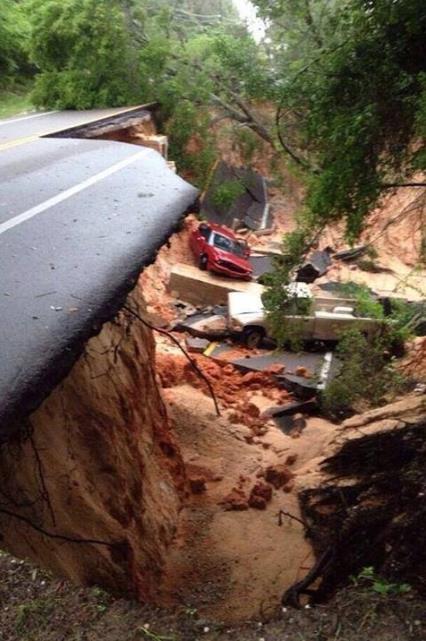
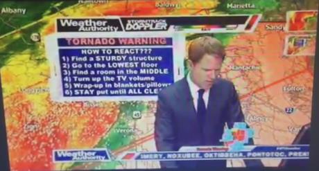
Mississippi Weatherman Evacuates On Air As More Tornadoes Hit The South.
Everyone wants to err on the side of caution, even the local
meteorologist in the path of a large, violent tornado. At least this
station in Tupelo has a basement, which came in handy Monday afternoon.
New York Magazine reports (check out the video clip): "...
A
video from NBC affiliate WTVA offers a dramatic illustration of that
point. On Monday afternoon chief meteorologist Matt Laubhan was reporting
on the storm live on air when a tornado touched down near the station
in Tupelo, Miss. After the feed stalls for a moment, Laubhan yells
"Basement, now!" to other employees, then runs off camera. Later, the
station tweeted "We are safe here..."
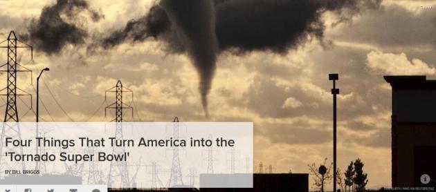
Four Things That Turn America Into The "Tornado Super Bowl". Where have you heard that before?
NBC News has an explainer, focused on why the USA experiences (far) more tornadoes than any other nation on Earth; here's a clip: "
A
one-of-a-kind combination of weather factors make the United States the
twister capital of the world, with the ominous funnels 10 times more
common in the states than anywhere else on the planet, scientists say.
The four main ingredients
all are geographical, all unique to America's borders: a massive
mountain wall to the west, a warm ocean to the southeast, a cold-air
“shield” to the north – and above these particular latitudes, a narrow
river of wind, the jet stream, that surges eastward at hundreds of miles
per hour..."
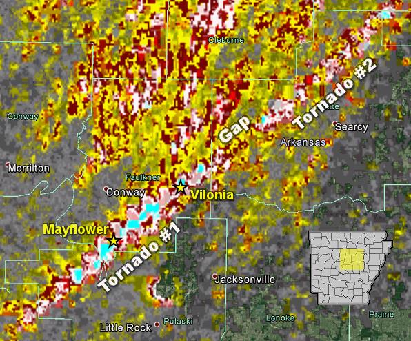
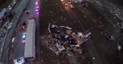
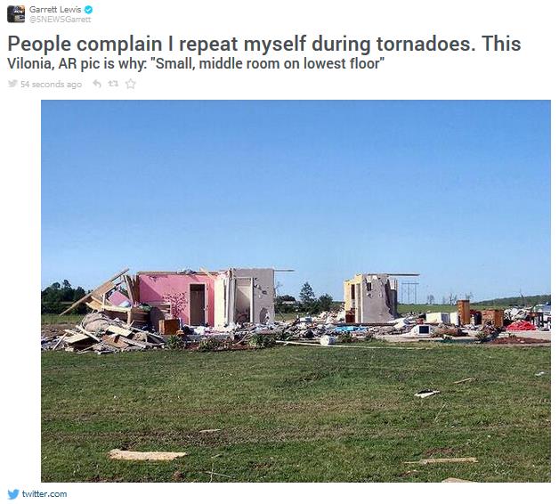
Little Rock Outbreak Details.
Here is additional information on the Sunday evening outbreak that
leveled parts of Vilonia and Mayflower, courtesy of the Little Rock,
Arkansas
National Weather Service: "
In
the picture: Rotation associated with the parent storm on 04/27/2014
was persistent for roughly 40 miles (Tornado #1) before weakening (where
the gap is indicated). Another tornado (Tornado #2) was likely spawned a
short time later by the same storm and tracked through White, Jackson,
and Independence Counties. Note: Tornado #2 may actually be several
tornadoes. This will be determined through damage surveys. The graphic
is courtesy of the National Severe Storms Laboratory..."
•
This is the strongest tornado to hit the state since the Denning
tornado on May 24-25, 2011. That tornado was rated EF4, with a path
length of 45.71 miles. Four were killed, 27 injured. The fatalities were
at Etna and Denning in Franklin County, and Bethlehem in Johnson
County, all in mobile homes.
• This is the second time in three
years that Vilonia has been hit by a tornado. The last time was April
25, 2011, when a long-tracked EF2 tornado hit, killing four.
•
Since reliable records began in 1950, Vilonia has seen five tornado
tracks within the present-day city limits. Aside from 4/27/2014, there
was 4/25/2011 (EF2), 12/24/1982 (F3), 12/23/1982 (F2), and 03/12/1961
(F2). Source: National Weather Service, Little Rock.
* 2 confirmed deaths from Sunday's tornado outbreak in Iowa.
Details here.
Preliminary Tornado Ratings:
EF-4: Louisville, MS
EF-3: Mayflower/Vilonia AR, Limestone County, AL (at least), Tupelo, MS
EF-2 : Union City, TN, Heard/Troup County, GA
EF-1 : Kimberly, AL (north Jefferson County)
Storm Chaser Says He's Retiring After Deadly Arkansas Tornado.
CNN has a remarkable interview with a storm chaser who's apparently had enough; here's the description: "
Deadly
tornadoes have left a path of death and destruction for miles in the
south. Our Ed Lavandera is in Mayflower, Arkansas where he caught up
with a storm chaser who came dangerously close to it all. He tells us
why his experience on Sunday will be his last."
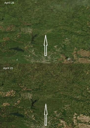
Tornado "Scar".
Chris Dolce
points out a comparison of high-resolution NASA MODIS images taken
before and after the Mayflower-Vilonia tornado. You can see the damage
swath left behind in the top image, taken April 28.
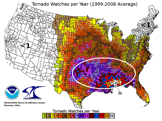
Most Tornado Watches?
Looking at data from 1999-2008 the most tornado watches issued by NOAA
SPC weren't in traditional Tornado Alley, but southern Alabama and
Mississippi; an average of 16 tornado watches every year. Not quite what
I was expecting.
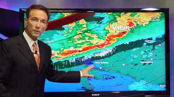
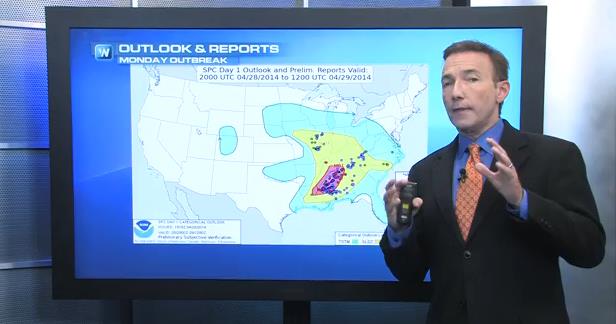
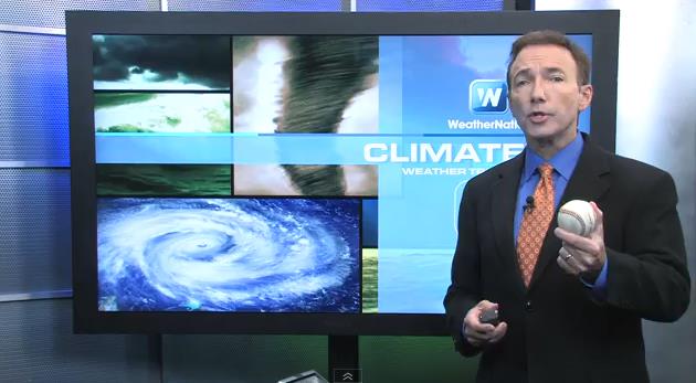
Giving Credit Where Credit Is Due.
Meteorologists take a lot of flak for missing forecasts, but the folks
at NOAA SPC in Norman, Oklahoma nailed the tornado prediction Sunday,
again on Monday. That's the topic of today's first
Climate Matters segment: "
WeatherNationTV
Chief Meteorologist Paul Douglas goes over the factors that went into
the historic tornado outbreak that dropped large destructive tornadoes
over Alabama and Mississippi. What has to happen to make a situation
like this occur?"
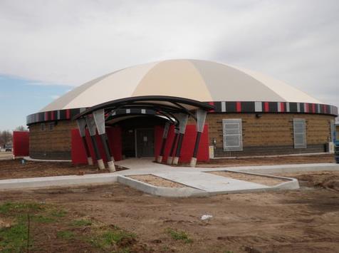
Dome It! Schools Can Affordably Survive Tornadoes.
Yes, tornadoes are a threat, and an opportunity to make our communities
more resilient and storm-prooof. Here's an excerpt of a timely,
interesting article from Andrew Revkin at
The New York Times: "...
I spoke Monday with David B. South,
the co-inventor of a dome manufacturing process 37 years ago whose
company, Monolithic Dome, has been erecting storm-safe domed school
buildings from Sarasota, Fla., through Geronimo, Okla., and Lumberton, Tex., and even west to Payson, Ariz. (where
the benefits include the big energy savings that come with thick
insulation and concrete). There are ways to build a safe haven into a
conventional school design, as well. But old building codes, tight
budgets and simple inertia continue to get in the way of change..."
Photo credit above: Monolithic Dome. "A domed building at the Dale, Okla., elementary school doubles as a tornado shelter and cafeteria."
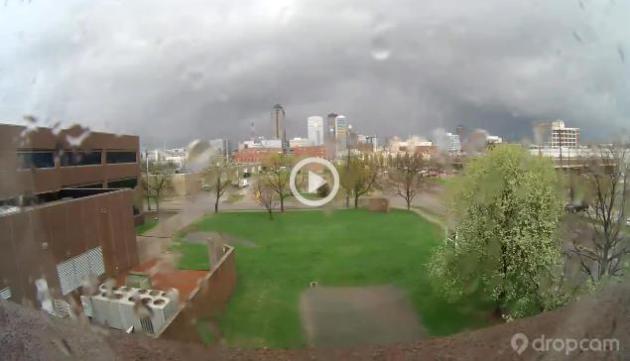
Supercell. Check out the
timelapse footage of a supercell thunderstorm passing over Des Moines, courtesy of meteorologist Jason Parkin. Great animation.
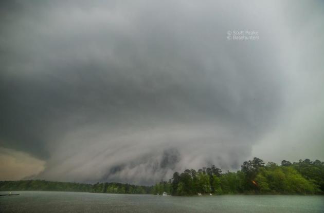
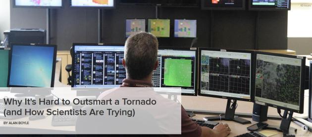
Why It's Hard To Outsmart A Tornado (And How Scientists Are Trying). NBC News
has an interesting story about the difficulty in determining which
supercell thunderstorms will go on to spawn large/deadly tornadoes. As a
nation we over-warn for twisters, which is probably better than the
alternative. Here's an excerpt: "...
As a result, Wurman said
forecasters tend to "overwarn" about tornadoes. The false-alarm rate for
tornado warnings is about 75 percent. But Brooks said it's better to
sound a false alarm than to risk missing a killer tornado. "That 75
percent number is a result of the fact that deciding whether this is a
tornado-making storm is a fundamentally hard problem," he said..." (Image: Gene Blevins, Reuters).
Tornado Tip-Offs.
Meet the new starting pitcher for the Twins. There's a sign of The
Apocalypse. No, I'm using visual aids to remind you about hail and
tornadoes. Most large, violent tornadoes are preceded or accompanied by
large hail. The larger the hail, the stronger the thunderstorm updraft.
The stronger the updraft the higher the probability of a supercell
powerful enough to tornado. That's the subject of this
Climate Matters segment: "
Large
destructive storms capable of dropping baseball sized hail and damaging
tornadoes don't happen where you think. WeatherNationTV Chief
Meteorologist Paul Douglas shows just where most of these powerful
storms are witnessed."
Tornadoes: The Science Behind The Destruction.
National Geographic has more good information and background on tornadogenesis - here's a clip: "...
Even then, "we still don't know why some thunderstorms create tornadoes while others don't," tornado-chaser Tim Samaras
said in early 2013. Samaras was a scientist and National Geographic
grantee who was killed by a twister on May 31, 2013, in El Reno,
Oklahoma. (Read "The Last Chase"
in National Geographic magazine.) Brooks says scientists believe strong
changes in winds in the first kilometer of the atmosphere and high
relative humidity are important for the formation of tornadoes. He adds
that there also needs to be a downdraft in just the right part of the
storm..."
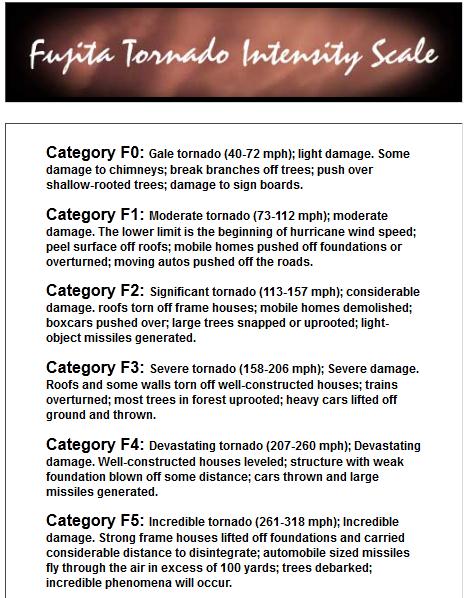
From "Gale" To "Inconceivable". Ranking Tornado Strength. Here's a good explanation of the new enhanced Fujita (EF) scale, courtesy of an article at
Time Magazine: "...
The
Enhanced Fujita scale was adopted in 2007. It was designed to more
accurately reflect the actual damage a tornado had done on the ground.
The EF scale uses 28 different damage indicators, ranging from small
barns to hardwood trees to shopping malls—and each of those indicators
is assessed based on several different points of possible damage..."
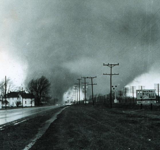
61 Facts About Tornadoes. Here are just a few from
abc15.com in Phoenix:
- "
A
tornado emergency is enhanced wording in a tornado warning indicating a
large tornado is moving into a heavily populated area. Significant
widespread damage and numerous fatalities are likely. The term was
coined by forecasters in May 1999 and is used sparingly.
- Enhanced Fujita Scale: The Fujita scale is used to estimate the wind speed of a tornado by the damage the tornado causes."
* details on the 1965 Palm Sunday tornado outbreak, featured above, from
Wikipedia.
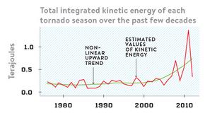
Yes, Tornadoes Are Getting Stronger.
To be fair and balanced, there is still no widely accepted scientific
gun that can directly connect the dots, to the point we can say "climate
change absolutely produces more numerous or more powerful tornadoes".
But this story out of
Wired just made me do a double-take; here's a clip: "...
A
tornado-power equation that actually gauges a twister’s kinetic energy
would be more useful to scientists who are also examining the effects of
climate change, so that’s what Elsner built. He looked at the length
and width of a storm’s damage path, correlated that to the amount of
damage, and then used the result to estimate wind 1.0 speed. A little
more crunching and bam!—integrated kinetic energy of a storm. Non-linear
upward trend estimated values of kinetic energy Elsner’s analysis
suggests that since the turn of the century, tornadoes have packed a
more powerful punch..."
Researchers Develop Model To Correct Tornado Records.
With Doppler (and a proliferation of storm chasers after the movie
"Twister" was released in the early 90s) we've seen an apparent uptick
in tornadoes. More people and technology looking for them. But are
tornadoes becoming more intense over time? Here's a clip from a story
posted by Florida State University: "...The
increase in reports has diminished the population bias somewhat, but it
introduced a second problem: There are more reports, but are there
also, in fact, more tornadoes? In other words, is the risk actually
increasing? To address these issues, the FSU researchers first made the
assumption that the frequency of tornadoes is the same in cities as in
rural areas. They also operated on the assumption that the reported
number of tornadoes in rural areas is low relative to the actual number
of tornadoes. Their model calls for the reported number in rural areas
to be adjusted upward by a factor that depends on the number of
tornadoes in the nearest city and the distance from the nearest city.
The model shows that it is likely that tornadoes are not occurring with
greater frequency, but there is some evidence to suggest that tornadoes
are, in fact, getting stronger..."
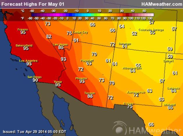
100-Degree Heat Brewing For Los Angeles Area - Records May Fall. 100F in late April? Here's an excerpt from
The Los Angeles Times: "
A
heat wave this week is expected to send temperatures soaring to 20
degrees above normal for much of the Southland, potentially breaking
records with triple digits in some areas, forecasters say. Building high
pressure is also expected to bring gusty Santa Ana winds to the region,
prompting warnings of high fire danger, particularly Tuesday through
Thursday, when temperatures could hit 100 degrees in some inland areas,
the National Weather Service said..."
* forecast graphic above: NOAA and
HAMweather.
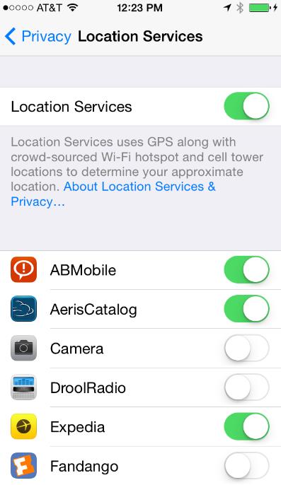
Phones Are Giving Away Your Location, Regardless Of Your Privacy Settings. No, you're not paranoid - you are being tracked until further notice. Maybe if I start using my old brick phone...?
Quartz has the story; here's an excerpt: "...
A
new study has found evidence that accelerometers—which sense motion in
your smartphone and are used for applications
from pedometers to gaming—leave “unique, trackable fingerprints” that
can be used to identify you and monitor your phone. Here’s how it works,
according to University of Illinois electrical and computer engineering
professor Romit Roy Choudhury and his team: Tiny imperfections during the manufacturing process make a unique fingerprint on your accelerometer data..."
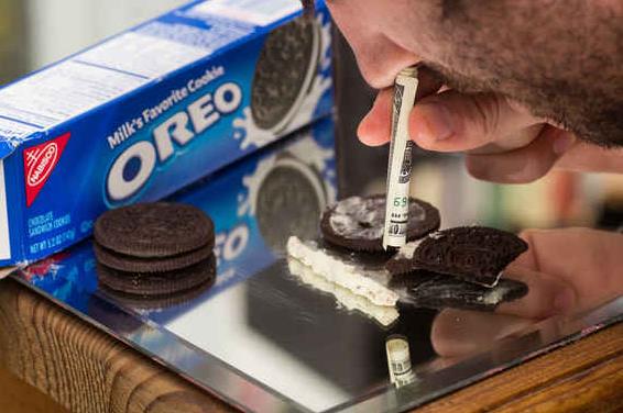
Confirming Our Suspicions: Oreos Are As Addictive As Crack. Here's a clip from a story at
Huffington Post: "...
Thanks for telling us what we already knew, science! Just last year, a team at Connecticut College got a bunch of lab rats,
Oreos, and cocaine, and set off for Vegas. Actually, they set up two
mazes. The first maze had Oreos at one end and rice cakes on the other;
the second promised an injection of saline on one side and an injection
of morphine/cocaine at the other. After they had received their prize,
the rats could choose to linger as long as they liked, presumably in the
hopes of seconds they would never get..."
Best TV News Bloopers Of April. There are some really good ones in here - video courtesy of
TVNewsCheck. (PG rated).
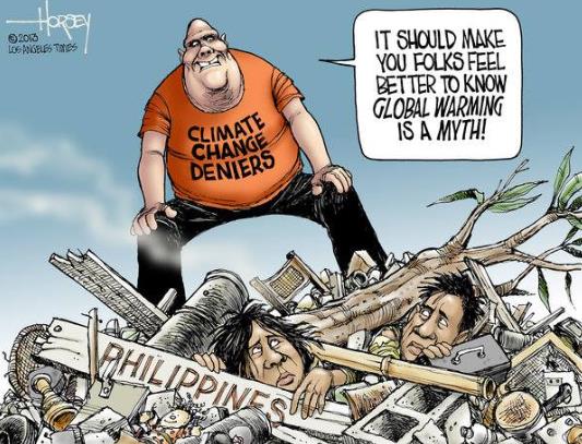
Climate Stories...
* cartoon courtesy of David Horsey at
The Los Angeles Times.
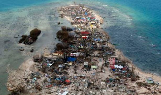
Typhoon Haiyan Was Just The Start - Prepare For An Even Stormier Future. As oceans continue to warm will hurricanes and typhoons become more intense over time? Here's an excerpt from
The Guardian: "...
The damage Haiyan caused outstripped any storm the typhoon-prone islands had experienced before. Reibl says typhoon Bopha
in 2012 had already redefined ideas on how big a typhoon could get, and
yet "just a year later, Haiyan made Bopha seem like just a little wind …
When Bopha happened we didn't envisage a Haiyan. Can we envisage
something more than Haiyan?" Reibl says that in the past the Philippines
were considered the 7-11 of natural disasters – small but open all
hours. Indonesia, with its large but infrequent disasters, was more like
a mega mall. He says the scale of devastation wrought by Haiyan meant
the Philippines had become "a mega mall that is now also open 24/7"...
Photo credit above: "
An aerial photograph of a coastal town in Samar province in central Philippines, taken on 11 November 2013." Photograph: Erik De Castro/REUTERS.
Top Military Commanders Have Declared Our Biggest Threat, And It's One We're All Ignoring.
I have a son in the Navy and I can assure you that Navy brass take
climate change very seriously. Seas are rising; that will impact Navy
ports in the years and decades to come. Anything that potentially
destabilizes economies and can spark conflict is of great interest to
the Pentagon. Here's an excerpt from
PolicyMic: "...
For
the U.S. military, climate change isn't just about sad-looking polar
bears and declining biodiversity. It's a real challenge that has the
potential to seriously destabilize nations and throw entire regions into
conflict, potentially escalating into wars that will require new
strategies and new technologies to win. In a recent interview with the Responding to Climate Change blog,
retired Army Brig. Gen. Chris King said that the military is extremely
concerned about climate change. "This is like getting embroiled in a war
that lasts 100 years..."
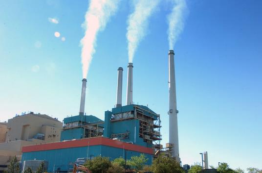
Supreme Court Backs EPA Rules For Coal Pollution.
The New York Times has an update - here's an excerpt: "
The
Supreme Court on Tuesday upheld the Environmental Protection Agency’s
authority to regulate coal-plant pollution that wafts across state lines
from 27 Midwestern and Appalachian states to eastern states. The 6-to-2
ruling
is a major environmental victory for the Obama administration, which
has instituted several new E.P.A. regulations under the Clean Air Act in
an effort to crack down on coal pollution. Republicans and the coal
industry have criticized the effort as a “war on coal...”
File photo: Matt Brown, AP.
Climate Scientist Katherine Hayhoe On Time Magazine's Most Influential People of 2014 List. Here's an excerpt of an interview with Dr. Hayhoe from
The University of Toronto: "...
I’m
encouraged when international relief and development organizations like
World Vision put climate change at the forefront of their concerns. I’m
inspired by faith leaders from Pope Francis to the U.S. National
Association of Evangelicals who emphasize how the Christian faith
demands a response to climate change. With 97 per cent of climate
scientists agreeing that climate change is happening due to the choices
people make every day, the simple truth is that the scientific debate is
over, and now it’s time for all of us, from every walk of life and part
of society, to take action..."


