Severe storms likely later today, affecting less
than 1% of the state. Damaging straight-line winds, large hail and a few
tornadoes can't be ruled out. Stay alert, make sure you have a NOAA
Weather Radio, and make sure you have an adequate shelter nearby.
4-9 pm. Time when severe storms are most likely in and near the MSP metro area.
Multiple Safety Nets. The more sources of severe storm information, the better:
NOAA Weather Radio. The only device that will alert you of a late-night tornado in your county.
TV, radio. Check batteries. Make sure you have a working flashlight in case power goes out.
Internet/E-mail. Monitor startribune.com for updates throughout the day. Check the latest videos for more info.
Smartphone apps. Many iPhone and Android apps can display Doppler and nearby watches/warnings.
Sirens (outdoor use only). Remember, the sirens were never meant to be heard indoors.
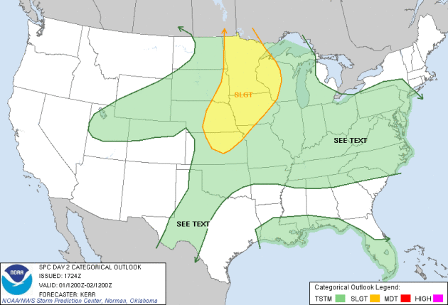
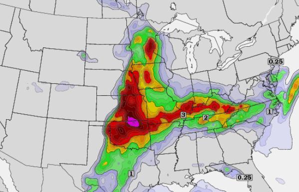
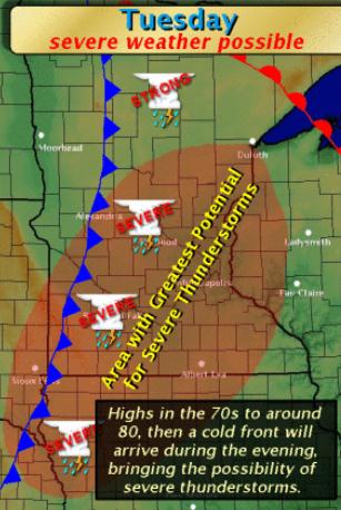
Today's Severe Storm Risk. Here is the latest overview from
NOAA SPC,
the Storm Prediction Center, showing a broad area of elevated risk from
Omaha and Sioux City to Des Moines, Sioux Falls, the Twin Cities,
Brainerd, St. Cloud and Duluth, and the western half of Wisconsin.
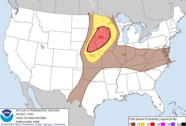
Severe Storm Probabilities. A 30% risk within the
red hatched area means a nearly 1 in 3 chance of severe weather (58 mph+
winds and/or 1" diameter hail) within 25 miles of any town in the
threat area. Translation: a good chance of severe storm watches and
warnings - I wouldn't be at all surprised to see a few tornado watches
issued for central and southern Minnesota later today. Stay alert and
stay tuned. Map:
SPC.
EHI. The energy-helicity index valid 7 pm this
evening shows the greatest risk of tornadoes over the Oklahoma-Kansas
border, but EHI values are very high over eastern Minnesota. EHI is a
parameter that combines helicity (wind shear) with instability to show
one number. This 0-3000 meter EHI index is courtesy of
twisterdata.com.
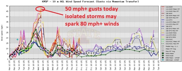
Potential Growing For Damaging Winds Later Today. I
want to stress that most of us will not experience damaging winds, but
the fact that winds are forecast to gust close to 50 mph. this evening
leads me to believe that we may see a squall line with (isolated)
reports of 70-90 mph. winds. Most of us will experience straight-line
winds, but a few isolated tornadoes can't be ruled out. Graphic:
University of Iowa meteorology department.
Tornado Safety: here is some good information courtesy of FEMA's
ready.gov:
| If you are in: |
Then: |
| A structure (e.g. residence, small building, school, nursing home, hospital, factory, shopping center, high-rise building) |
- Go to a pre-designated shelter area such as a safe
room, basement, storm cellar, or the lowest building level. If there is
no basement, go to the center of an interior room on the lowest level
(closet, interior hallway) away from corners, windows, doors, and
outside walls. Put as many walls as possible between you and the
outside. Get under a sturdy table and use your arms to protect your head
and neck.
- In a high-rise building, go to a small interior room or hallway on the lowest floor possible.
- Put on sturdy shoes.
- Do not open windows.
|
| A trailer or mobile home |
- Get out immediately and go to the lowest floor of a
sturdy, nearby building or a storm shelter. Mobile homes, even if tied
down, offer little protection from tornadoes.
|
| The outside with no shelter |
- Immediately get into a vehicle, buckle your seat belt and try to drive to the closest sturdy shelter.
- If your vehicle is hit by flying debris while you are driving, pull over and park.
- Stay in the car with the seat belt on. Put your head
down below the windows; cover your head with your hands and a blanket,
coat or other cushion if possible.
- If you can safely get noticeably lower than the
level of the roadway, leave your car and lie in that area, covering
your head with your hands
- Do not get under an overpass or bridge. You are safer in a low, flat location.
- Never try to outrun a tornado in urban or congested
areas in a car or truck. Instead, leave the vehicle immediately for
safe shelter.
- Watch out for flying debris. Flying debris from tornadoes causes most fatalities and injuries.
|
* photo of June 17, 2010 Albert Lea tornado courtesy of WeatherNation TV meteorologist Aaron Shaffer.
Tornado Preparedness. From
CDC, the Center for Disease Control and Prevention: "
Take
a few minutes with your family to develop a tornado emergency plan.
Sketch a floor plan of where you live, or walk through each room and
discuss where and how to seek shelter."
- Show a second way to exit from each room or area. If you need
special equipment, such as a rope ladder, mark where it is located.
- Make sure everyone understands the siren warning system, if there's such a system in your area.
- Mark where your first-aid kit and fire extinguishers are located.
- Mark where the utility switches or valves are located so they can be turned off--if time permits--in an emergency.
- Teach your family how to administer basic first aid, how to use
a fire extinguisher, and how and when to turn off water, gas, and
electricity in your home.
- Learn the emergency dismissal policy for your child's school.
- Make sure your children know--
- What a tornado is
- What tornado watches and warnings are
- What county or parish they live in (warnings are issued by county or parish)
- How to take shelter, whether at home or at school.
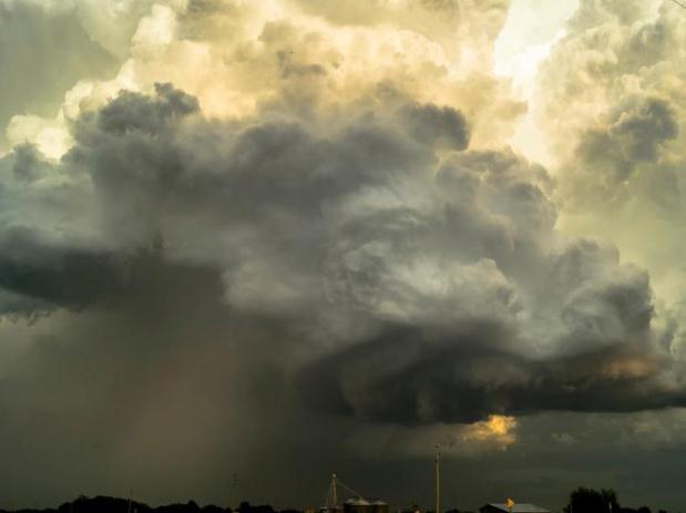
Tornado Tip-Offs. I start to get nervous when I see any of the following conditions:
1).
Wall Cloud. Lowering, rotating cloud base. This "wall cloud" is where tornadoes are most likely to spin up.
2).
Large hail. The larger the hail, the stronger
the T-storm updraft, the greater the potential for tornadoes. I start to
worry when hailstones are golf ball-size or larger. Baseball-size hail?
Head to the basement. Don't wait for warnings or the sirens to sound.
3).
Debris visible: sparks on high-tension wires. These are additional tell-tale signs that a tornado circulation may be reaching the ground.
4).
Black/green sky. A green or yellowish tint to
the sky often means significant hail in the thunderhead overhead. It's
not a foolproof tip-off, but trust your gut, and your instincts. If
winds are increasing sharply, and large hail is falling, it's time to
head for the basement, or a small, windowless room near the interior of
your home or office.
* The smaller the room, the better. The more walls between you and the tornado, the better.
Severe Storm Potential. The local
Twin Cities office of the National Weather Service has outlined the greatest threat area, covering most of central and southern Minnesota.
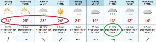
Sliding Into A Stormier, Wetter Pattern. The good
news: we're about to put a big dent in our ongoing drought. The bad
news: the surge of warmth and moisture will spark a few severe storms,
especially later today and Wedneday. Highs reach well into the 70s,
possibly topping 80 today and tomorrow, with a gradual cooling trend by
the weekend. The ECMWF (European) model prints out nearly 2" of rain
next Monday. We'll see, but from a moisture standpoint the models are
encouraging.
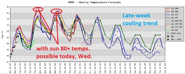
Hints of June. The U.S. model suite shows highs
possibly topping 80 today and tomorrow - depending on how much sun we
experience. If clouds/stratus/fog lingers into midday we'll have to be
content with mid 70s. If the sun is out through midday then 80 F. is a
pretty good bet. The warmer the mercury, the more unstable the airmass
overhead, the greater the potential for a severe outbreak by evening.
All the models show readings cooling into the 60s and low 70s by the
weekend; right now Saturday looks a few degrees milder than Sunday.
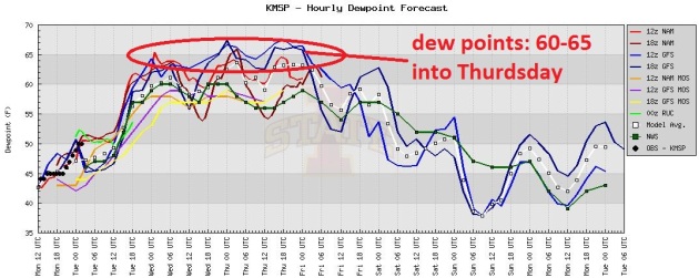
Dripping Dew Points. All the models show the dew
point rising above 60 today, and staying in the 60-65 F. range into
Friday. There will be plenty of moisture in the air, enough fuel for
strong/severe T-storms.
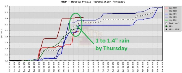
Great News For Fields, Lawns and Gardens. It's not
enough rain to replenish low lake-water levels, but it's a big step in
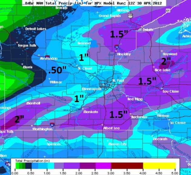
the right direction. Models are suggesting over 1" of rain by Thursday
night, maybe 2"+ amounts for parts of Minnesota and western Wisconsin.
Soaking Rains? A robust warm frontal boundary draped
over central Minnesota and Wisconsin will act as a magnet for "waves"
of showers and T-storms - best chance late afternoon into the overnight
hours; storms will tend to weaken rapidly during the morning hours. The
latest NAM predicts over 1" of rain for the Twin Cities metro by
Thursday night, with some 1-2" amounts over southern Minnesota and
western Wisconsin.
"
Spread joy. Chase your wildest dreams." - Patch Adams
"
Last year the Arctic Monitoring and Assessment Program (AMAP)
concluded that Arctic temperatures in the past six years were the
warmest in measured history. Each year since 2001, summer ice coverage
in the Arctic Ocean has been at, or near, a new record low, a pace that
predicts ice-free summers in the Arctic Ocean in the next 30 or 40
years." - from an Op-Ed in West Virginia's wvgazette.com.
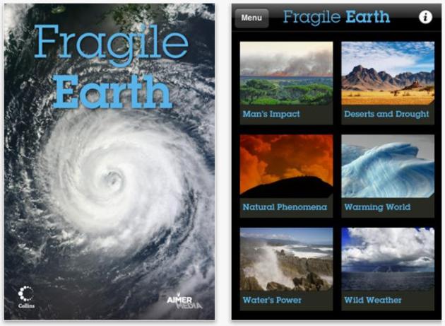
"Fragile Earth". An app that allows you to track climate change around the planet - details below.
86% of the Kentucky corn crop planted, 56% has emerged. That's double the 5-year average for May 1.
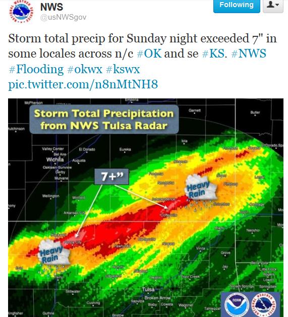
Oklahoma Flood Potential. Check out the
tweet from The National Weather Service - Doppler radar estimates show some 7" rainfall estimates just north/west of Tulsa.
Monday Hail reports:
2230 425 15 NE GAIL BORDEN TX GOLF BALL, TENNIS BALL AND SOFTBALL SIZE HAIL BROKE WINDSHIELDS ON VEHICLES. (MAF)
2145 275 2 N POST GARZA TX WINDSHIELD BROKEN OUT BY HAIL ON 207 NORTH OF POST. (LUB)
2211 200 10 ENE POST GARZA TX HALF MILE WIDE SWATH OF HAIL AT HIGHWAY 380 AND 208. LARGEST HAIL MEASURED AT 2 INCHES. (LUB)
2150 200 NE INGALLS GRAY KS (DDC)
2210 200 4 W NEWLAND AVERY NC HAIL UP TO SIZES LARGER THAN GOLF BALL FELL FOR ABOUT 30 MINUTES AT THE FRANK VFD. (GSP)
Monday Wind reports:
2115 70
HOPKINSVILLE, KY THUNDERSTORM WIND GUST
ESTIMATED 70 MPH. LOCATION WAS AT THE INTERSECTION OF THE BYPASS AND FT.
CAMPBELL BLVD. (PAH)
* thanks to Seth Carrier from Earth Networks (formerly WeatherBug) for passing these reports along.
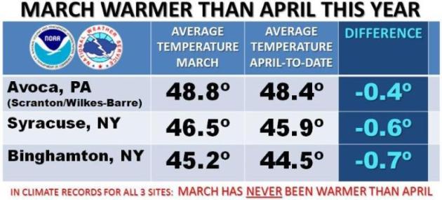
A Warmer March Than April? Amazing, but true. Details from the
NWS office in Binghampton, New York: "
For
the first time EVER in our climatological records, April has turned
out to be colder than March. These stats do not yet include today, April
30th, but will change very little (by 0.1 of a degree or so at most)
when the final numbers are calculated."
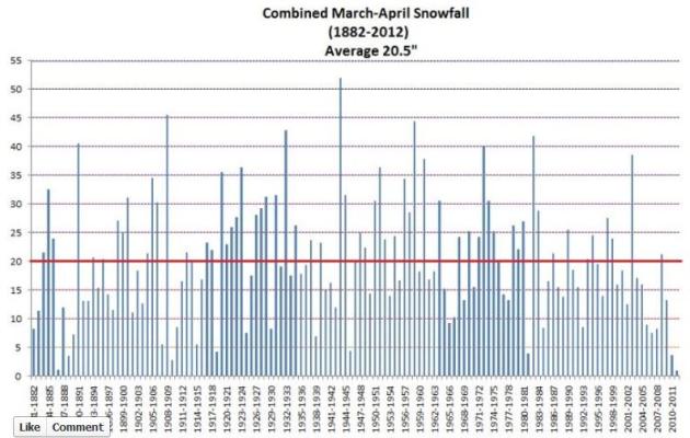
Record March-April Snowfall Deficit For Denver. Here's an interesting post from the Denver/Boulder office of The National Weather Service, via
Facebook: "
The
total snowfall for March and April combined was 1.0”. This is the
lowest combined March-April Snowfall on record dating back to 1882. The
previous low was 1.1” in 1887. The average is normally 20.5” based on
the period of record. Furthermore the last two years the combined
March-April Snowfall has been below 5.0”. This has never happened before
dating back to 1882."
2.88" rain at Miami Sunday, a new 24-hour rainfall record for April 29. Old record: 2.58" in 2011. Source: NOAA.
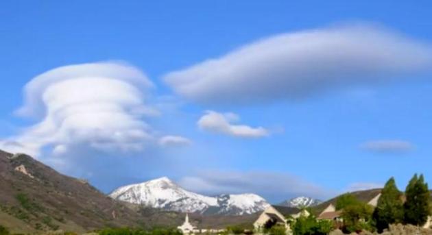
Video of The Day: "Lenticularis". Here is a great
YouTube timelapse of lenticular (wave clouds) from Draper, Utah: "
High winds after a period of storms produced some awesome lenticular clouds."
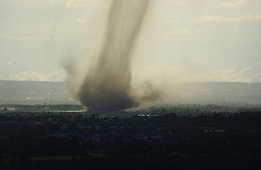
Spectacular Snaps Of Tornado That Tore Through Toulouse (France). Check out some amazing photos from
The U.K. Sun: "
A
tornado touched down in southern France yesterday - long enough to be
captured in a series of spectacular pictures and videos. Storm chasers
snapped the dust-laden funnel, known as an F-1 tornado, as it stormed
through Toulouse at speeds of up to 112mph."
* no, that's not a typo: tornado chasers in
southern France. That's a new one.
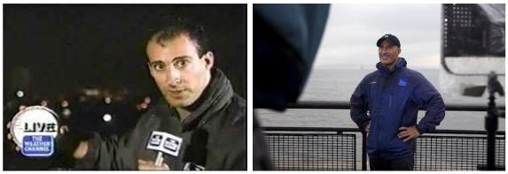
Weather Channel's 30th Anniversary Plans. Details from Media Bistro's
TVNewser: "
On
Wednesday, The Weather Channel will celebrate 30 years on the air. The
channel is planning a celebration on-air online and in the real world.
For starters, the Empire State Building will be decked out in “Weather
Channel Blue” lights for the anniversary. On-air, there will be a
retrospective looking back on 30 years of coverage, as well as
interviews with key players, employees and on-air personalities.
Celebrities and prominent figures will offer congratulations, and a
blooper reel will be played."
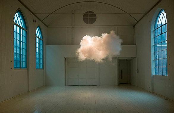
Artist Floats "Real Clouds" Indoors. I need one of these machines - that way my forecast will never be wrong.
AccuWeather.com has more details: "
Dutch artist Berndnaut Smilde floated clouds indoors for two art exhibits in the Netherlands. Smilde used a fog machine to build the clouds in the room."
Freedom Tower: 11 Beautiful Instagram Images of NYC's Tallest New Building.
Mashable.com has the story; here's an excerpt: "
A
steel beam was secured to One World Trade Center Monday, making it
officially the tallest building in New York City. The tower now stands
at 1,271 feet, and users on Instagram
have been sharing their view of the building from all over New York,
using the hashtags #WTC1 and #FreedomTower. Once finished, the building
will be 1,776 feet have 104 floors, including 71 office floors with 3
million square feet of space."
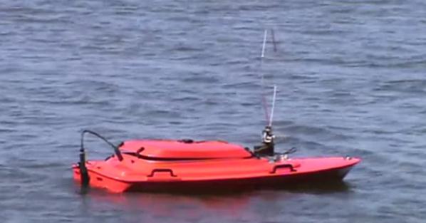
Robotic System For Monitoring Carp in Lakes. Check out a
YouTube clip to see what a few innovators at the
University of Minnesota are building to (remotely) monitor invasive species in Minnesota's lakes and rivers: "
This video introduces our work on building a robotic sensor network to find and track radio-tagged invasive fish. Visit: http://rsn.cs.umn.edu/ for more details."
Alcoa Announces "Smog-Eating" Architectural Panels.
Smart companies like Alcoa are looking at liability and opportunity and
realizing that there is plenty of green to be made by going green.
Details from
gizmag.com: "
Last
week that giant multinational of aluminum production Alcoa announced
its new "smog-eating" architectural panels - in other words cladding
stuck to a building's exterior that can remove pollutants from the
surrounding air. The aluminum panels, branded Reynobond with EcoClean
technology, have a titanium dioxide coating which breaks down
pollutants in direct sunlight."
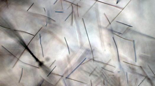
Photo credit above: "
A high-magnification photo of a sand grain containing titanium dioxide in the form of rutile (Photo: Bob Richmond via Flickr)."
Mommy Confession: I Let My Toddler Wear Make-Up. Good grief. I saw a tweet from KMSP and had to get more details on this "breaking story"; more details from
mommyish.com. Yep, "ish" kind of sums it up: "
This
weekend, my daughter had her spring pre-school performance. As we were
getting ready, practicing her songs and pulling out her “good shoes,”
she walked into the bathroom and reminded me that I needed to plug in
the curling iron. “Mom,” she bellowed from across the house, “you need
to turn on the hot curly thingy.” Brenna and I have a pretty solid
“dress-up” routine. Every holiday, performance, or any other event that
she deems necessarily fancy, we pick out a pretty dress, curl her hair
and then we apply a little make-up. Alright, we apply a full face of
make-up. On both of us."
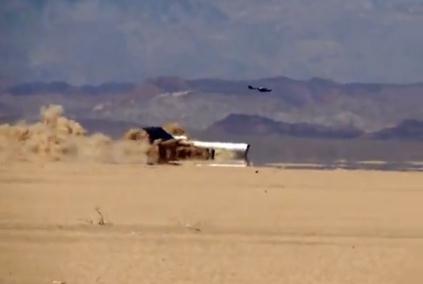
Discovery Channel Crashes 727 To See To, Um, See What Happens. Speaking of crashing and burning,
CNET.com has details on a perfectly good waste of a Boing 727: "
It
is always a little frightening to see a plane plummet towards Earth,
especially if you're often forced to travel in one. What might it have
looked like for those who, last Friday, watched a 727 crashing in the
Mexican desert -- with the full knowledge and co-operation of the
pilot? I am grateful to the Daily Mail for making my Monday so much more exciting with this information. According to a Discovery Channel press release,
this was done in the service of "an unprecedented international
television documentary for Discovery Channel, Channel 4 in the UK, plus
Pro Sieben in Germany."
Photo credit: "
(Credit: Screenshot: Chris Matyszczyk/CNET)."
Microsoft's Nook Investment Totals $300 Million, Barnes and Noble Weights Spin-off Of Digital Business. Here's an excerpt of an interesting story from Reuters and
Huffington Post: "
(Reuters)
- Microsoft Corp will invest $300 million in Barnes & Noble Inc's
digital and college businesses, valuing them at $1.7 billion. Shares of
Barnes & Noble jumped 79 percent. Microsoft will get a 17.6
percent stake in the new unit, while Barnes & Noble will own about
82.4 percent, the companies said in a statement on Monday. The
business, whose name has not yet been decided, will have an ongoing
relationship with Barnes & Noble's retail stores." Photo above: Barnes and Noble.
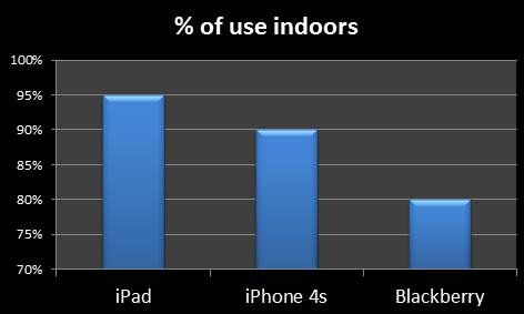
Why We Love To Use iPad Indoors: WIFI. The details from
gigaom.com; here's a snippet: "
By
analyzing data from a live 3G network in a major city, the mobile
network analytics and optimization specialist has found that only 5% of iPads are used outdoors and whilst iPads account for just 1% of data sessions, they use four times more data than an average 3G device. Key findings from the study were:
- iPads account for less than 1% of all data sessions but make up 5% of total traffic."
Berries Can Keep Your Brain Sharp. So this is why my
dear wife is force-feeding me berries: she's trying to keep my brain
sharp! But you just can't sharpen a rusty knife. That said, there is
some good information in this story from
gizmag.com; here's an excerpt: "
Everyone
knows that strawberries and blueberries are good for you. Now a new
study by researchers at Brigham and Women’s Hospital (BWH) has found
that eating as little as two servings of flavonoid-rich strawberries
and/or blueberries a week can delay memory decline in older women by
over two years. The research team used data from the Nurses’ Health
Study, which involved more than 120,000 registered nurses between the
ages of 30 and 55. The nurses completed health and lifestyle
questionnaires beginning in 1976, and have been surveyed every four
years since regarding their eating habits. Starting in 1995, memory was
tested in participants older than 70 every two years. Women included
in the present study had a mean age of 74."
Photo credit above: "
Eating two servings of strawberries and blueberries a day can delay memory decline in older women (Photo: Shutterstock)."
"
True friendship comes when silence between two people is comfortable." - Dave Tyson Gentry
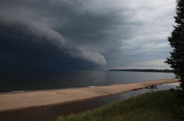
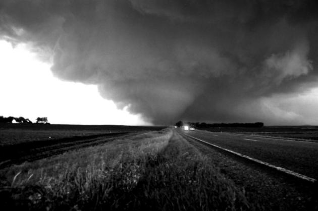
* wall cloud photo above courtesy of Skywarn Spotter Paul Brooks.
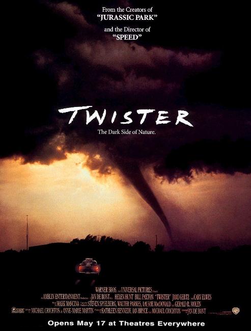
"Safe Rooms"
Ever since the movie "Twister" thousands of
would-be amateur photographers have taken to America's highways,
checking Doppler, trying to be at the right place at the right time,
capturing tornado footage that will a). get them paid, and b). show up
on TV.
I have mixed feelings. The swarm of tornado
chasers is triggering potentially dangerous traffic jams, in some cases
making it harder for first responders to reach tornado damage. But
studies repeatedly show that many Americans don't head to the basement
until they SEE that the tornado threat is real. Warnings and sirens
simply aren't enough to get some off the dime.
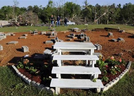
No basement? Consider spending a few thousand
dollars to reinforce an interior closet. These "safe rooms" are booming
down south and might be a good idea for northern homes. In recent years,
for a variety of reasons, many still unclear, some of the largest, most
violent tornadoes have been touching down outside of traditional
"Tornado Alley". In 2010 Minnesota experienced the most tornadoes in the
USA (145). There's no evidence that this spring/summer season will
rival 2010 - but we need to be ready.
You know the drill: small, windowless rooms on
the ground floor afford the most protection (closet or bathroom usually
works best). If you're in an office the safest place is an interior
(concrete-reinforced) stairwell or bathroom. If a warning is issued and
you're home with the kids consider football or hockey helmets. Don't
laugh. Most tornado injuries are blunt head trauma. A helmet could - in
theory and reality - save your life.
T-storms later today may be severe - I expect a
few tornadoes fairly close to home. The good news: no more jackets. If
the sun comes out we may hit 80 through Friday. A damp start Saturday
gives way to slow clearing; the best chance of Sunday storms over
southern Minnesota.
"
The sun, the moon and the stars would have disappeared long
ago...had they happened to be within the reach of predatory human hands." - Havelock Ellis, "The Dance of Life", 1923
Climate Stories...
Joe Wyatt: Global Warming Is Real. Here's an excerpt of a must-read Op-Ed from heart of "clean" coal country: West Virginia's
Sunday Gazette-Mail: "
....Limbaugh
has yet to explain how the researchers' well-oiled scheme was put into
place. If Rush is correct, thousands of scientists have put on hold
their self-involved hopes for the Nobel Prize so that they may
surreptitiously conspire to deceive us about air temperature. And they
have done this unobserved, even though they work for numerous
governments, hundreds of agencies, dozens of universities and a myriad
of research groups in far-flung nations. One wonders whether Rush
suffers hallucinations in which secret handshakes are exchanged at
clandestine meetings in little used rooms of dusty basements far beneath
the classrooms of ivy-covered chemistry buildings. In contrast to such
paranoia, the National Climatic Data Center said that 2010 was the
second hottest year in history, after 2005. The National Oceanic and
Atmospheric Administration (NOAA) reported that more than 15,000 warm
temperature records fell nationwide during March this year."
Listen To The Skeptics! Except When They Talk Nonsense. From
Climate Central: "
I
got an email the other day from an occasional visitor to the Climate
Central website, asking whether we’d be covering a series of recent
challenges to conventional climate science. He was being facetious: he
knew we probably wouldn’t, and he was right — clear evidence, he
proclaimed triumphantly, that our claim of following the science
wherever it leads is just a lot of empty talk. My first reaction was:
“how dare you suggest such a thing!” But that’s a throwaway line, not a
response, and I thought I should provide a fuller answer. The bottom
line is that we ignore people who claim to have found holes in the
mainstream ideas of climate change if their claims don’t make lot of
sense. Who gets to decide? Well, we do. But it’s not arbitrary: there’s
a thought process behind it, and it’s a pretty valid one, though it’s
not infallible."
Photo credit above: "
Galileo, Alfred Wegener and Ignaz Semmelweis."
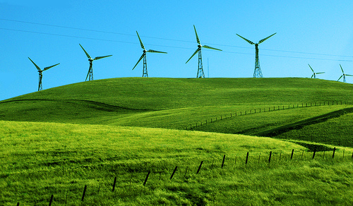
U.S. Wind Energy At The Crossroads. Here's a video clip from
climatecrocks.com: "
Wind
energy is not a future resource, it is here now. There is no question
that it will be a primary part of our energy mix in the future. The
only question is, will we build those millions of turbines here in the
US, or will we concede the growth industry of the 21st century to our
competitors."
Wind Farms Can Increase Night Time Temperatures, Research Reveals.
An interesting potential symptom of turning turbines: it keeps the air
stirred up at ground-level, preventing the coldest air from settling to
ground level, as reported by
The Guardian: "
Large
windfarms can increase local night time temperatures by fanning warmer
air onto the ground, new research has revealed. The study used
satellite data to show that the building of huge windfarms in west Texas
over the last decade has warmed the nights by up to 0.72C. "Wind power is going to be a part of the solution to the climate change, air pollution and energy
security problem," said Liming Zhou, at the University of Albany in
New York. "But understanding the impacts of windfarms is critical for
developing management strategies to ensure the long-term sustainability
of wind power."
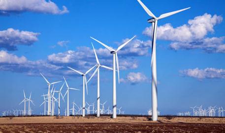
Photo credit above: "
Wind turbines generating
electricity at Horse Hollow Wind Farm Nolan, West Texas, the world's
largest wind power project. Photograph: Alamy."
Wind Farms May Have Warming Effect: Research. Details from Reuters and the
Baltimore Sun: "
LONDON
(Reuters) - Large wind farms might have a warming effect on the local
climate, research in the United States showed on Sunday, casting a
shadow over the long-term sustainability of wind power. Carbon dioxide
and other greenhouse gases from burning fossil fuels contribute to
global warming, which could lead to the melting of glaciers, sea level
rise, ocean acidification, crop failure and other devastating effects,
scientists say."
Flooding Spreads Invasive Species In Vermont, Iowa, Louisiana. Here's a snippet from a story at
Huffington Post: "
BETHEL,
Vt. (AP) — Last year's hurricanes and flooding not only engulfed homes
and carried away roads and bridges in hard-hit areas of the country,
it dispersed aggressive invasive species as well. In Vermont, the
floodwaters from Tropical Storm Irene and work afterward to dredge
rivers and remove debris spread fragments of Japanese knotweed, a plant
that threatens to take over flood plains wiped clean by the August
storm. The overflowing Missouri and Mississippi rivers last year
launched Asian carp into lakes and oxbows where the fish had not been
seen before, from Iowa to the Iowa Great Lakes. Flooding also increased
the population along the Missouri River of purple loosestrife, a plant
that suppresses native plants and alters wetlands."
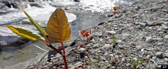
Photo credit above: "
In this April 26, 2012, photo,
Japanese knotweed grows on a stream bank in Bethel, Vt. The flood
waters of Tropical Storm Irene and work to remove silt and restore
roads afterward had an unintended consequence: they spread Japanese
knotweed, an invasive plant that has already clogged some river banks
and roadsides in Vermont. (AP Photo/Toby Talbot)."
Which Hotel Chain Has The Smallest Carbon Footprint?
The fact that a major media outlet is even asking the question is an
encouraging sign. Here's an excerpt of an interesting story from
The L.A. Times: "
If
you want to shrink your carbon footprint when you check into a hotel,
you may be better off staying at a mid-range or budget chain hotel.
That's the conclusion from a report released last week by Vermont-based Brighter Planet,
the eco-minded tech firm that creates digital apps and other
technology to measure environmental impacts. The report said the
nation’s hotels use 4% of all commercial building energy per year and
generate 34.7 million metric tons of greenhouse gas emissions. The most
energy- and carbon-efficient hotel chain in the U.S., according to
Brighter Planet, is Vagabond Inn, followed by Red Lion Hotels, both
mid-range national hotel chains. Red Carpet Inns, a budget hotel chain,
came in third."
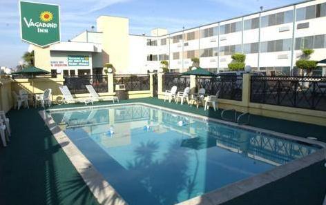
Photo credit above: "
The most energy- and carbon-efficient
hotel chain in the U.S., according to Brighter Planet, is Vagabond
Inn. Above, the Vagabond Inn in Long Beach
(Priceline.com / April 27, 2012)."
App Depicts Impact Of Climate Change On Planet.
Reuters has details: "
Called Fragile Earth, the app for iPhone and iPad
shows how our planet is impacted by global warming by featuring more
than 70 sites such the receding Muir Glacier in Alaska, the impact of
Hurricane Katrina in New Orleans and the draining of the Mesopotamia
Marshes in Iraq. "We
don't necessarily put an opinion on it," said Jethro Lennox, head of
publishing at Collins Geo, a division of Harper Collins UK which created
the app. "We're just trying to visually portray some of the
geographical features and changes around the world."
Report: China Doing Most Global Warming Abatement, Global Greenhouse Gas Emissions To Peak In 2016, But Still Not Enough. Details from
Clean Technica: "
The
DB Climate Change Advisors has released its latest Global Climate
Change Policy Tracker report [PDF], its fourth. The report has quite a
bit of interesting info in it. Most important, from a global
perspective, is that “the best case global outlook” based on potential
current targets still leaves us is with “a 5.8Gt ‘gap’ compared to a
450ppm stabilization pathway.” And even 450ppm is way to high according
to top climate scientists."