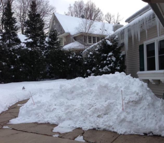
Drought Disconnect
I'm getting e-mails from incredulous readers,
staring out at RV-size piles of snow, wondering how on Earth we can
still be in a drought? 44.8 inches in the metro so far this winter? 1
inch ABOVE average, to date? We may see our normal allotment of 54
inches of snow this winter season. A minor meteorological miracle.
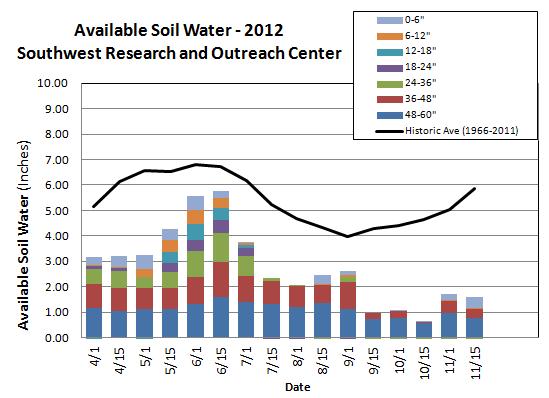
State Climatologist Greg Spoden explains why
that thick snow cover is more mirage than medicine. "Minnesota's 2012
crop drank from subsoil reserves established during an incredibly wet
May. Those reserves are now gone. The soil moisture profile is
critically depleted. The white veneer of snow on the landscape lies upon
a frozen topsoil that will allow little infiltration. To recover from
our present drought situation, abundant spring rains are required after
the soils thaw" he wrote via e-mail.
We are seeing an uptick in wet storms. But will
the rains still come, after we lose the 20-40 inches of frost in the
ground? Time will tell.
We may hit 40F by Saturday with a cold rain,
ending as a little Sunday slush. Models are hinting at 40s the end of
next week; even a shot at 50F in 2 weeks.
Note to self: play in the snow ASAP. I'm happy to write you a note.
 New England Nor'easter
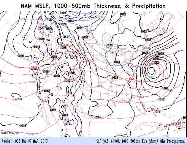
. The latest (00z)
NAM
model
shows the storm that walloped parts of Virginia with 1-2 feet (but
sparing the immediate Washington D.C. area) temporarily stalling, with
moisture rotating all the way around the storm, approaching from the
north tonight and Friday, enhancing the potential for plowable snows
from New York to Providence and Boston, maybe a cool foot of snow just
inland. A southwestern storm spreads rain into Minnesota Saturday,
possibly ending as a little slushy snow Sunday, but any amounts should
be light.
 From Alerts Broadcaster
:
* This is one of the most difficult forecasts in recent years:
significant wet snow is still likely from New York suburbs into interior
New England, but major city centers from New York to Boston wavering
on rain-snow line, making final snowfall prediction even more
problematic than typical.
* Rain mixes with snow Thursday; some melting on contact with warmer
surfaces in New York City and Boston - but a slushy accumulation is
still expected, with the greatest potential for accumulation Thursday
night over the colder suburbs. Precipitation ends as light rain Friday;
by then plowable amounts of wet snow are expected.
* 1-2" liquid water from this slow-moving coastal storm: high water
content reduces risk of blowing/drifting, but increases potential for
power outages, especially NYC suburbs to Providence and western suburbs
of Boston.
High Bust Potential. Our goal with these briefings
is to be totally transparent; no media hype or bluster. When
uncertainty is high we tell you so. And the risk of a "bust" is still
very high with this storm, due to mild air off the Atlantic being
absorbed into this Nor'easter. To pick up all snow temperatures in the
lowest mile of the atmosphere need to be (consistently) below freezing.
Latest models indicate a thin layer of warm air near the ground
Thursday, which may result in a rain-snow mix from New York City to
Boston (better chance of heavy wet snow just inland, over the suburbs).
Even so, a plowable accumulation (at least 3-4") is still very
possible from Manhattan to downtown Boston, enough to disrupt some
operations and complicate commutes and air travel. Heavy, wet, slushy
snow with high water content will mean a minor to moderate risk of
power outages Thursday and Thursday night.
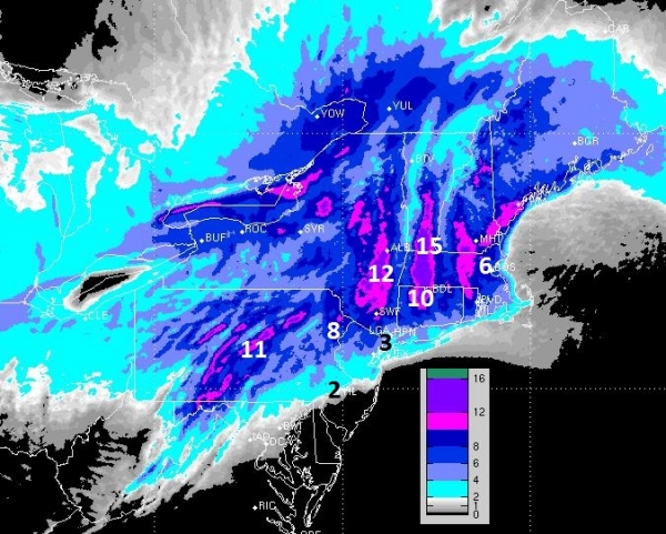
Dueling Models. The latest NAM model above shows
some 8-10"+ amounts from New York's suburbs into Providence and the
western suburbs of Boston (everything shaded in bright red). We've had a
couple model runs in a row showing similar results, so there is some
continuity from run to run. But the ECMWF (European) model is
suggesting mostly rain for New York City and Boston; too much warm air
sweeping in off the Atlantic for significant snowfall totals. That
said, surface winds are forecast to blow more from the north than the
east or northeast later today into Friday, which may tip precipitation
over to mostly (wet) snow, especially inland. March storms are
especially difficult; this one is no exception.
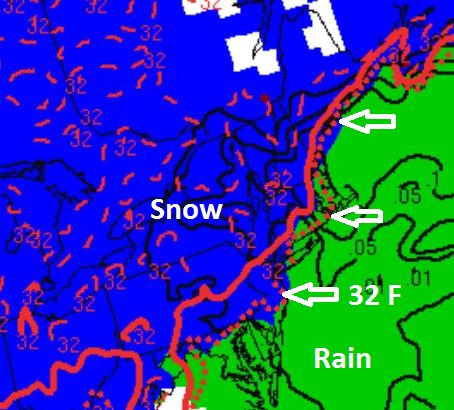
Rain-Snow Line. High resolution models valid
Thursday night show the 32-degree F. isotherm running from Midtown
Manhattan to Providence to Boston; mostly rain east of that line,
mostly snow to the west over interior New England. This is why this
forecast is so difficult; a 25-50 mile shift in that line could make
the difference between mostly rain, and 6-12" of heavy wet snow.
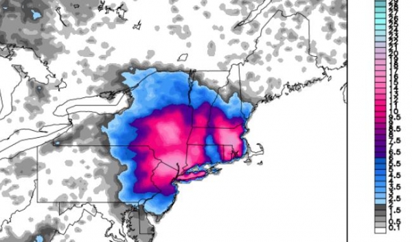
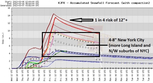
Statistics & Probabilities. Assuming a mix of
rain and snow the most likely amount for much of New York's 5 boroughs
is something in the 4-8" range by Friday morning. Of course there will
be variations across the city, with the greatest potential for 10-12"+
amounts over central and eastern Long Island, and from northern New
Jersey to Westchester and Fairfield counties. But if precipitation
falls as (mostly) snow amounts could still be higher in the city, with a
least a 20-25% probability of final amounts closer to 10-12" before
rain mixes in on Friday.
Boston Numbers. I expect a big variation in
snowfall totals in the Boston area, a couple inches of slush near
Boston Harbor to as much as 6-8" Newtown and Waltham, maybe 1-2 foot
amounts over southeastern Massachusetts to near Providence. Factor in
coastal flooding (storm surge of 4-8 feet) and the next 48 hours will
be see a significant risk to facilities from high winds, power outages
and traffic disruptions.
Summary: one of my biggest pet peeves is having a
meteorologist give me 4 different scenarios of what may happen. That's
not a forecast, but a wish-cast, an excuse to cover your butt for any
eventuality. I'm still predicting a heavy, wet slop-storm of rain and
snow from New York City to Boston, with just enough slush to shovel and
plow - probably plowable for most neighborhoods - but the heaviest
amounts over the suburbs, with a moderate risk of coastal flooding at
high tide and sporadic power outages a very real possiblity, especially
well inland, away from the coast.
This will NOT be as disruptive as the February 9 blizzard,
but there will be substantial impacts on facilities, travel plans and
the power grid. Odds still favor a messy mix for major city centers,
which will keep final snow totals down. Suburban snow totals will be
more significant with this sloppy, fickle Nor'easter. The forecast is
rarely black or white, but usually some nebulous shade of gray. This is
one of those moments; a very difficult forecast, but the potential for
disruption to operations is still significant. Another update Thursday
morning.
Extreme Weather Makeover: Has Abnormal Become The New Normal? Good question. The short answer is yes. Rick Montgomery has the story at
The Kansas City Star; here's an excerpt: "
Those
drought-damaged evergreens outside? Regional climatologists say to
expect more in the years ahead. And the surreal mounds of snow now
hiding shrubs that barely survived summer’s heat? Get used to that, too.
It seems contradictory, this weird weather whiplash. But just consider
the last couple of years in the nation’s midsection. Floods unleashed
by record inflows into the Missouri River basin in early 2011. Then
sudden and prolonged dryness. Now 20 to 25 inches of snow heaped on
Kansas City in the most dramatic, back-to-back smacking delivered by any
winter week that many of us can recall. Yet to experts who study
climate change models, it makes sense. Think extreme..."
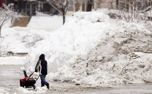
Photo credit above: "
A man pushes a snowblower around a
giant pile of snow left by road crews in the Country Club Plaza shopping
district of Kansas City, Mo., Tuesday, Feb. 26, 2013. For the second
time in a week, a major winter storm paralyzed parts of the nation's
midsection Tuesday, dumping a fresh layer of heavy, wet snow atop
cities still choked with piles from the previous system and making
travel perilous from the Oklahoma panhandle to the Great Lakes. The
weight of the snow strained power lines and cut electricity to more
than 100,000 homes and businesses. At least three deaths were blamed on
the blizzard." (AP Photo/Orlin Wagner)
Read more here: http://www.kansascity.com/2013/03/02/4096394/extreme-weather-makeover-has-abnormal.html#storylink=cpy
Read more here: http://www.kansascity.com/2013/03/02/4096394/extreme-weather-makeover-has-abnormal.html#storylink=cpy
Predicting The Snows That Matter Most. In 1977 there
was one weather model, the LFM. Now there are hundreds, even thousands
of weather models. What to believe, when, and why? This article from
UCAR delves into how ensemble modeling has revolutionized weather forecasting; here's an excerpt: "...
One
reason why these eye-popping snowfall totals didn’t come as a surprise
is the growth of ensemble prediction. Little more than a decade ago,
U.S. forecasters had access to only a handful of fresh runs of computer
models every few hours to guide their snow forecasts. Today, there’s
not only a broader range of models, but some of these models are run
multiple times, side by side, with small changes in the starting-point
conditions that mimic the gaps in our less-than-perfect weather
observing network. Such ensembles are helping forecasters deal with
such high-impact threats as the “Snowquester” winter storm expected to
strike the Washington, D.C., area this week..."
Severe Weather Preparedness Week. March 3-9 marks
the official (nationwide) kick-off of Severe Weather Preparedness Week;
here are some timely details and reminders of 2012 from
FEMA: "
Every year, thousands of people are impacted by severe weather threats such as tornadoes and severe thunderstorms.
Preliminary data for 2012 shows there were more than 450
weather-related fatalities and nearly 2,600 injuries. Every state in the
U.S. has experienced tornadoes and severe weather, and although some
more than others, everyone is at risk. You can take steps to prepare
for when severe weather strikes in your area. Knowing the most common
weather hazards in your area, your vulnerability, and what actions you
should take can save your life and others..."
Next Generation Weather Satellite Could Offer Earlier Warnings.
GOES-R will enable meteorologists to see real-time lightning within
thunderheads (from low-Earth orbit). Lightning, or a lack of lightning,
can be a cue for tornado formation, one of many reasons why this new
generation of weather satellites may help to improve severe storm
forecasting. Here's an excerpt from
redOrbit.com: "...
GOES-R,
part of a scientific collaboration between NASA and NOAA, will be the
next generation of geostationary weather satellites. The team claims
GOES-R will provide continuous imagery and atmospheric measurements of
Earth’s Western Hemisphere. Additionally, the GOES-R will monitor space weather,
as well. This new satellite will also become the primary method for
detection and tracking of hurricanes and severe weather. GOES-R will aid
in the improvement of applications and products that will fulfill
NOAA’s goals of Water and Weather, Climate, Commerce and Ecosystem.
“These storms can spin up pretty quickly which limits warning
lead-time,” said NOAA scientist Steve Goodman. “The radar and storm
spotter’s view of tornadoes reaching the ground can be blocked by
terrain, or visibility is very poor when the tornado is wrapped in rain.
And it’s certainly more challenging for storm spotters to observe and
confirm tornadoes occurring at night. Sometimes it’s just plain hard to
come up with enough advance warning...”
Image Credit:
Photos.com
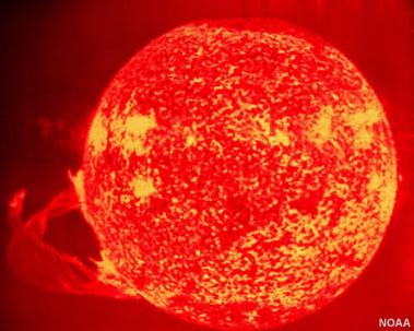
The Dangers Of Space Weather. We're all fixated on
blizzards, tornadoes and meteorites, when our next unwelcome surprise
could very well come from Earth's nearest star.
Geology.com has an interesting story on space weather; here's an excerpt: "...
With
effective alerts and warning, we can limited the effects of space
weather on real-time technology. For example, satellites can be
adjusted, power grids can be modified, and polar flights can be
rerouted. Scientists and forecasters work closely with government and university
partners to develop prediction models and other tools to improve
services to the nation's space weather community. SWPC also helps move
the latest computer models of solar dynamics and sun-Earth interactions
into the daily operations of space weather prediction. NOAA and
partner agencies in the National Space Weather Program are leading the
way in this new era of space weather awareness to provide timely,
accurate information and forecasts to help keep our advanced-technology
global economy moving forward..."
(Photo: NOAA).
"Ask Paul". Weather-related questions, comments and assorted threats:
Paul-
Has the definition of drought changed? I grew up during the Great
Depression and drought mean farmers getting NO CROPS at all. How can
this now be called a drought when the farmers continue to reap the
biggest crops in the history of this country? As I peer out the windows
of the senior's bus I see small ponds along the roadside as we travel to
Willmar. When one can see ponds, how can this be called drought? When I
grew up they could plant tomatoes in lake bottoms (eg. West Norway Lake
in Kandiyohi county); there are pictures to prove that statement. Now
that was drought - when the lakes dried up! What has happened to the
above definition? Could you address this in your column? Thanks.
(Name Withheld By Request)
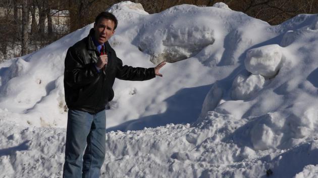
Great question, and I realize there's a disconnect when you look out
at all that (new) snow in your yard, scratching your head, wondering how
most of the state can be in severe/extreme drought? Frost levels are
still 20-40 inches deep, which means melting snow will run off and not
be able to soak into topsoil, where it's needed. I teed up your question
with Greg Spoden, State Climatologist for Minnesota. Here is his
response:
Hi Paul,
The reader raises a fair point. Modern drought monitoring attempts to
describe the continuum between the extraordinary conditions he observed
during the 1930s drought and no drought at all. The most widely used
tool for doing so is the
U.S. Drought Monitor,
a multi-agency effort to detect and identify the nation's drought areas
and assign those areas an intensity level. This effort requires a blend
of science and subjectivity. Drought intensity categories are
determined by the relative rarity of the climate anomaly
(precipitation/temperature departures from average, length of the dry
spell, etc), and the observed drought impacts. Some of those impacts are
offered
here.
In modern terms, the drought described by the reader would be
classified as "D4 - Exceptional Drought", the same conditions currently
plaguing much of the Great Plains. Thankfully, Minnesota's present
drought status does not reach that level of severity. Minnesota's
drought is the result of a very dry summer and autumn 2012.
Minnesota's 2012 crop drank from subsoil reserves established during an incredibly wet May. Those reserves are now gone. The
soil moisture profile
is critically depleted. The white veneer of snow on the landscape lies
upon a frozen topsoil that will allow little infiltration. To recover
from our present drought situation, abundant spring rains are required
after the soils thaw.
Greg Spoden, State Climatologist
Minnesota Department of Natural Resources - Division of Ecological and Water Resources
University of Minnesota - St. Paul Campus.
Thanks Greg - appreciate the additional information and perspective on the drought.
 Washington D.C. Is The Worst During A Snowstorm
. Very true, and I had a (rare) LOL moment reading this post of "Noquester" from
buzzfeed.com. Definitely worth a look. If you've ever been to Washington D.C. or have family there, this will resonate.
 Climate Stories....
Study Finds Climate Change To Open Arctic Sea Routes By 2050
Climate Stories....
Study Finds Climate Change To Open Arctic Sea Routes By 2050. Great news for shippers! Bad news for the rest of the planet, I fear. Here's a portion of a story at
NPR: "
Climate
change will make commercial shipping possible from North America to
Russia or Asia over the North Pole by the middle of the century, a new
study says. Two researchers at the University of California ran seven
different climate models simulating two classes of vessels to see if
they could make a relatively ice-free passage through the Arctic Ocean.
In each case, the sea routes are sufficiently clear after 2049, they
say. The study, published Monday in the journal PNAS
by Laurence C. Smith and Scott R. Stephenson, found that the sea ice
will become thin enough that a "corridor directly over the north pole"
will open up. "The shortest great circle route thus becomes feasible,
for ships with moderate ice-breaking capability..."
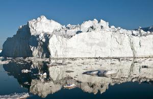
Photo credit above: "
An iceberg in or just outside the
Ilulissat fjord, which likely calved from Jakobshavn Isbrae, the
fastest glacier in western Greenland, in May 2012. Polar ice sheets are
now melting three times faster than in the 1990s.
" Ian Joughin/AP
GAO Warns Climate Change Could Drain Federal Budget.
Some of the same Congressional leaders who deny the reality of climate
change are now experiencing sticker shock - the price tag for this new
weather-on-steroids environment. Here's an excerpt of a story at
usgovinfo.about.com: "
Apparently convinced that climate change will result in more frequent and more severe weather-related natural disasters, the Government Accountability Office
(GAO) reports that the federal government is not well prepared to deal
with the resulting financial losses. The threat of significant losses
to the federal budget due to climate change topped the GAO's 2013 list
of government programs it considers to be at "high-risk" of resulting
in financial losses or waste, fraud or abuse..."
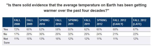
The Climate Change Rebound. Here's a clip of an interesting story (and poll) from
The Brookings Institute: "...
Notably,
Obama's retreat on this topic corresponded not only with policy
reversals but also with decreased levels of public belief that climate
change was occurring. Between 2008 and 2010, the National Surveys on
Energy and the Environment (NSEE) from the University of Michigan and
Muhlenberg College found a 20 point decline in the percentage of
Americans who believed there is solid evidence of global warming. But as
American acceptance of global warming rebounded in 2012 to levels
approaching the peak level of belief that was found in 2008, Obama has
once again taken a more aggressive public stance regarding the need for
government action to address the issue..."
Climate-Change Science Poised To Enter Nation's Classrooms. Here's a segment of a story from InsideClimateNews.org and
Bloomberg: "
New
national science standards that make the teaching of global warming
part of the public school curriculum are slated to be released this
month, potentially ending an era in which climate skepticism has been
allowed to seep into the nation's classrooms.The Next Generation Science Standards were
developed by the National Research Council, the National Science
Teachers Association, the American Association for the Advancement of
Science, the nonprofit Achieve and more than two dozen states. They
recommend that educators teach the evidence for man-made climate change
starting as early as elementary school and incorporate it into all
science classes, ranging from earth science to chemistry..."
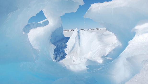
Photo credit above: "
A study published on Jan. 6 in Nature
Climate Change estimates more melting of the Freenland and
Antarctica's ice sheets than previously thought, which would raise sea
levels and have "profound consequences for humankind." Photographer: Alexandre Trouvilliez/CNRS/ice2sea
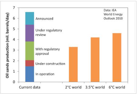
The Most Important Figure About The Oil Sands. Here's an excerpt from Simon Donner at
Maribo: "
Are
the oil sands a "carbon bomb"? Will the construction of new pipelines
unleash this "bomb" on the climate? There's lots of confusion about
these questions. On Friday, the U.S. State Department's released
an assessment that stated the Keystone XL pipeline would have a
negligible climate impact, essentially because a market analysis
suggested that other options will arise for transporting additional
carbon from the oil sands. Environmentalists are crying foul, energy and
industry experts are arguing both sides, and pundits are wondering why
the report was released on a Friday afternoon, when few people follow
the news. It's hard to know who to trust. The figure (above), based on
one figure made by Keith Stewart from Greenpeace and shown to me by
Mark Jaccard in the fall, suggests the answer to both questions could
be considered "yes", but not in the way people normally suggest..."
Graphic credit above: "
The first column is existing,
planned and announced oil sands projects; the orange bars are oil sands
production in the IEA future scenarios. Production is assumed to be 80%
of capacity, following the IEA methods.