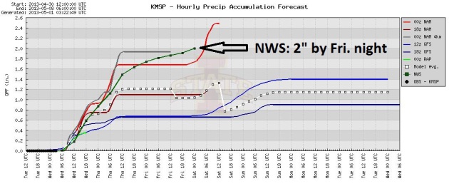
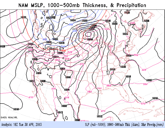
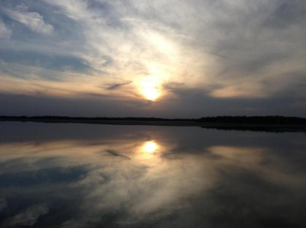
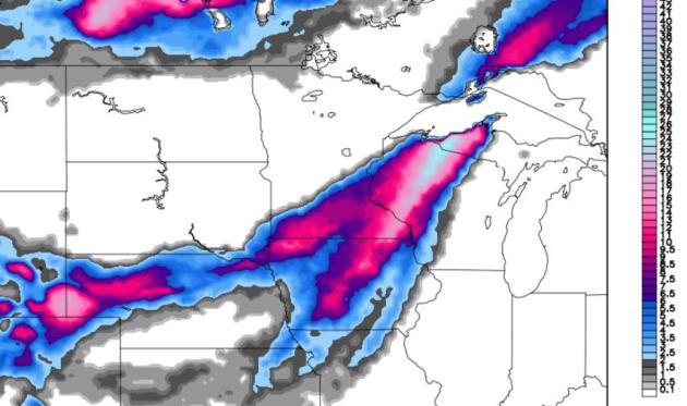
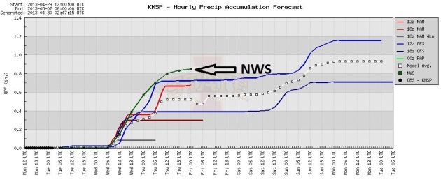
2.27" precipitation by Saturday morning (00z NAM model).
Cold rain today, mixes with wet snow by late afternoon or evening.
2-5" slushy snow possible tonight. Best chance of 3-4"+ southern/eastern suburbs of the Twin Cities.
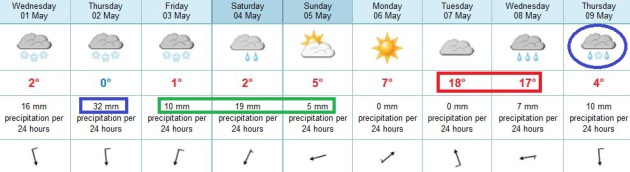
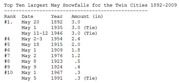
3" all-time record for May snowfall from a single storm (most recently in 1946).
5 days with 2"+ snow in May at KMSP since 1891. Source: Minnesota State Climate Office.
Rain expected late Friday into Sunday; a second surge of Gulf moisture.
Flood Warnings posted for some rivers up north from Ft. Ripley and Long Prairie to Scanlong. Details from NOAA
here.
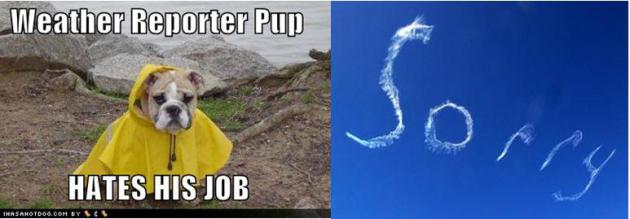
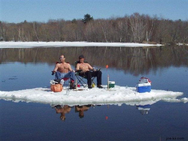
Mayday! Mayday!
"Hey, it's Minnesota. What do you expect?" the
old timer complained, sneaking a look at the sky while shaking his head,
sadly. Good point.
Silly me, I thought spring might stick this time.
With accumulating snow possible by tonight I'm
doing the only sensible thing: I'm going on strike. Rolling the Doppler
into the lake - sneaking into KARE-11's "Backyard", holding up a big
picket sign. These are intolerable working conditions.
There have been only 5 two-inch-plus May snowfalls in the Twin Cities since 1891, so yes, this is very unusual.
Numbing air over central Canada, displaced
unusually far south, is responsible for this March-like time warp -
enough cold air in the lowest mile of the atmosphere for an historic
slush-storm.
The ground is warm (it was 81F Sunday) so any
snow will melt on contact this afternoon but we may still wake up to a
slushy 2-5" by Thursday AM. A plowable 3-7" snow may fall on some
suburbs. Unreal.
A storm stalling over Missouri changes snow back to rain Friday & Saturday.
Before spending the morning with my therapist,
then heading out to man the picket lines, let me attempt to reassure you
that 60s & 70s should return next week.
Yes, spring has lost its bounce.
Not Again. Hey, I'm ready to track mosquitoes, dew
points, even a few tornadoes, if that's what it takes to get consistent
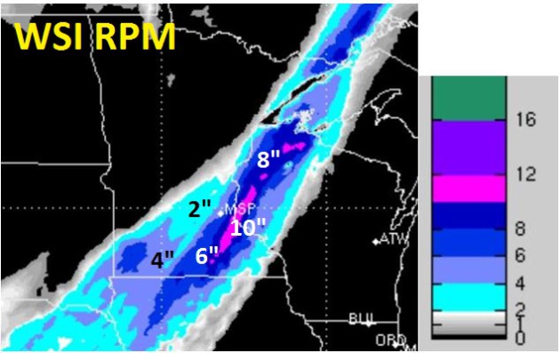
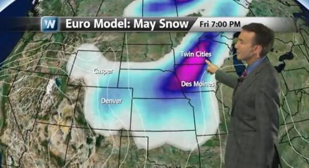
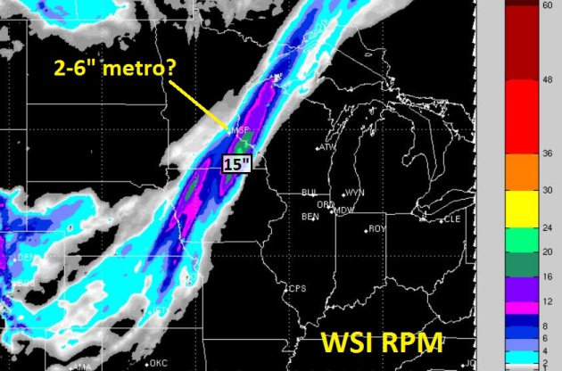
warmth up here. WSI's 12km. RPM model shows the heaviest snow band
setting up just south/east of MSP; a narrow band of 8-10" from near
Northfield to Hastings and Stillwater, with some 2-5" amounts for much
of the metro tonight and Thursday morning. A slam dunk? No. It never is,
but I suspect a very slushy start for your Thursday,
with a 60% probability of setting an all-time May snowfall record for the Twin CIties. Hey, if it's 'gonna snow - let's go for a record.
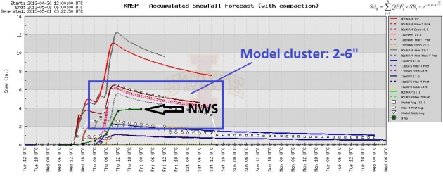
Model Solutions. Expect another very heavy, wet,
slushy snow tonight (ratio close to 7:1). Snow will melt on contact for a
time this afternoon and early tonight, but start to accumulate on lawns
and fields after 7 or 8 pm. Models seem to be converging on a solution
in the 2-6" range, ECMWF suggests the heaviest amounts will be over the
northern/western suburbs, NAM shows the axis of heaviest snow setting up
over the southern/eastern suburbs. Plowable by Thursday morning? Yes -
probably.
The Drought Is Over. O.K. I'm jumping the gun a
little - but my point is this: the pattern is wet, and it's persistent.
The drought is already over for most of the Twin Cities metro, and I
expect the drought to slowly fade over central and western Minnesota in
the weeks ahead. Some good news for Minnesota farmers - the chilly
weather is a hassle, but a huge north-south temperature contrast has set
the stage for a series of storms capable of (finally) tapping moisture
from the Gulf of Mexico.
Two Surges of Gulf Moisture. Surge #1 arrives today
and tonight, starting as rain, then changing to a rare May snow event by
tonight as a north wind cools the lowest mile of the atmosphere. Snow
tapers Thursday morning; then a second surge of moisture arrives from
the southeast Friday PM, temperatures aloft warming enough for rain
(thank God). A "cut-off" low, cut off from the main belt of westerly jet
stream winds will wobble and spin over Missouri, funneling 1-2"
precipitation into MSP by Sunday. NAM animation: NOAA.
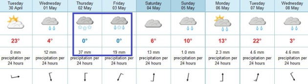
May Madness. From 81F. on a Sunday to 30s and heavy
wet snow on a Wednesday night, to rain late Friday into Sunday, to highs
near 70 early next week, to a possible mix (again?) by next Thursday,
with a cooling trend as we sail into Fishing Opener Weekend. It's too
early to say with certainty, but the odds of a lukewarm Fishing Opener
are fading fast. Surprised? Me neither.
Freak Spring: A Mixed Blessing In The Weather Department.
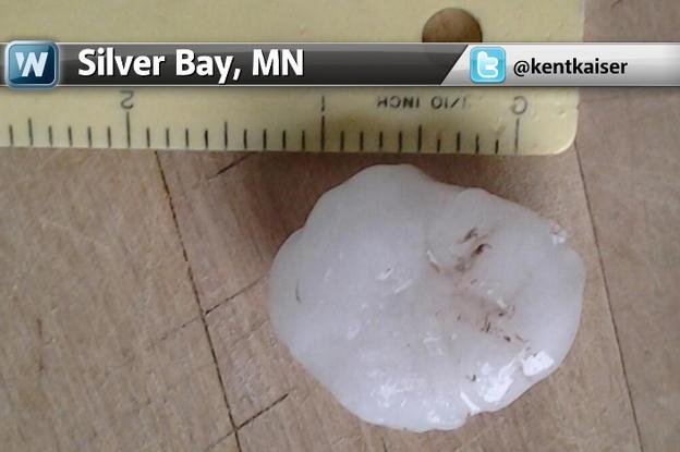
It hailed Tuesday in Silver Bay, Minnesota - warnings were issued for
1-2" diameter hail. Not all that unusual for late April, until you
consider that hail was falling on 6-10" snow still left on the ground.
Here's today's edition of
Climate Matters,
which examines the high amplitude jet stream pattern responsible for
easing the drought east of the Mississippi - and unseasonably cold,
snowy weather farther north and west: "
Meteorologist Paul Douglas
looks at how rare it is for cities like Denver and Minneapolis to see
May snowstorms. Plus what's causing this late spring cold blast around
the United States."
Clashing Seasons. Severe Storm Warnings were posted
for Lake Superior's North Shore Tuesday morning, reports of 1.5"
diameter hail at Silver Bay. What makes this unusual is the fact that
large hail was falling on ground still largely snow-covered. Thanks to
Kent Kaiser and WeatherNation TV for passing this along.
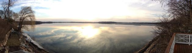
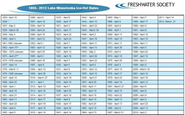
Ice-Out. It's not official, but most of the ice
seemed to come off Lake Minnetonka on April 28-29, nearly 2 weeks later
than usual. Here's an overview of how ice-out is calculated on 'Tonka,
courtesy of
The Freshwater Society: "
On
Lake Minnetonka the ice is designated as "out" when it is possible to
travel by small boat from any shore to any other shore through any
passage on the lake. Ice-out dates have been determined using this
method since 1968. Previous methods include: when the ice was 50% gone,
when a boat could circle Big Island, when a boat could travel between
Wayzata and Excelsior, when a car fell through the ice and by visual
observations from a number of lake locations."
Lake Minnetonka Ice-Out Dates. Last year ice-out came on March 21, in 2011 it was April 14, a bit closer to average.
PDF document above courtesy of The Freshwater Society.
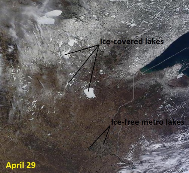
Ice-Out From Space. Here is Monday's
1,000 meter resolution NASA MODIS image,
showing ice covered lakes over roughly the northern half of Minnesota -
snow on the ground still clearly visible over the northern third of the
state.
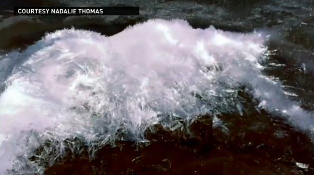
Strange "Chandeliering Ice" Phenomena Unfolds At Medicine Lake. Check out the remarkable video and explanation from
kare11.com: "...
On
a day in which spring made its return to Minnesota with a vengeance,
Nadalie Thomas caught Old Man Winter making his last stand with an
ice-shattering spectacle known to some as "chandeliering." Nadalie and
her kids were down on the shores of Medicine Lake in Plymouth Saturday
when they noticed large piles of ice that were splintering into fine
shards similar to glass. As spectacular as the visual image was the
ear-splitting sound that accompanied the icy scene..."
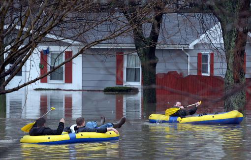
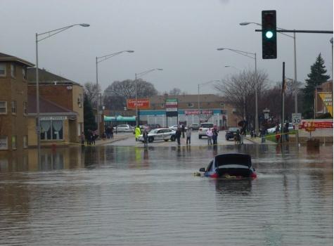
Flood Victims Compare Homes To War Zone.
NBC Chicago has the video; here's an excerpt of their story on recent historic flooding in the Chicago area: "
Less
than a week has passed since a regional super storm dumped billions
of gallons of water on Illinois homes, and caused devastating
floods. Some homeowners, finally able to move about without canoes or
flotation devises, are tearing apart flood ravaged homes. Resident's of
flood ravaged Forest View, where about 90 percent of the town was
evacuated, compared their town to a war zone. It's an idea backed up by
images of heavy machinery moving debris from place to place. "Take a
look around," said one homeowner near 46th street and Winona Avenue.
"It's like war zone. It's unbelievable. People have lost everything.
Their personal belongings, their houses everything. It's just
devastating..."
Media credit above: "
Nick Ariano, from left, Rick Watson
and Keith Andrzejewski head out to rescue the grandmother of
Andrzejewski, near Ogden and Rt. 53 in Lisle, Illinois, during heavy
flooding on Thursday, April 18, 2013". (Antonio Perez/ChicagoTribune/MCT)
Tornado Sirens Giving Way To New Warning Technology.
The new frontier is smartphones and even GPS-enabled tablets; check
with your local wireless carrier to see if these new (free) warnings
from NOAA are enabled. Here's an excerpt from
USA Today: "...
Cellphone
alerts, rolled out nationally last year, are called "wireless
emergency alerts." "They are up and running," said Tod Pritchard, a
spokesman for Wisconsin Emergency Management. "It's a great tool."
Pritchard said a cellphone is like a mini-radio that gets signals from
surrounding cellphone towers. When a tornado warning is issued for a
particular county, every cellphone tower there would transmit a
warning to phones in range. A phone that receives a warning message
will sound an alert. "It's not just a standard ring or the ring tone
you've selected. It has a different sound to it," Pritchard said. Along
with the tone, phones will display a short text message. A tornado
warning might say, "Take shelter immediately..."
* more information on these new Wireless Emergency Alerts for each carrier from
The CTIA.
. The first time public safety is threatened there will be howls of protest - wait for it. Here's an excerpt from
bradenton.com: "...
Federal
officials say they have the resources to warn storm-prone areas about
weather emergencies, but a federal union representative warns that a
hiring freeze plus furloughs threaten public safety. Aircraft known as
Hurricane Hunters will keep flying into storms to measure wind speed
and air pressure, though their flight crews will have to take turns
being furloughed. Weather satellites will remain on track, though the
offices that monitor them will get squeezed. Officials say they can
maintain adequate staffing at the National Hurricane Center near Miami,
though its forecasters will be forced to take off four unpaid days by
Sept. 30. Staff at the National Weather Service already is depleted
because of a hiring freeze...." (Hurricane Hunter file image courtesty of NOAA and AP).
10 Best-Selling Informercial Products. Snuggie comes in at number 8? How can that be? Here's an excerpt from a fun little article at
Mental Floss: "
Snuggie
did not invent the blanket with sleeves (that honor goes to the
Slanket folks), but they did popularize the item with a series of widely
seen and totally laughable commercials that insisted the behemoth
blanket was the product viewers had always wanted. They must have done
something right, because more than 20 million Snuggies have been cuddled up with to date.
Of course, it helps that the product is big with groups; bar crawls
and sporting events are just a few of the Snuggie-required group
activities that have helped push those numbers up. In April 2010, Los
Angeles Angels fans set a Guinness World Record when more than 43,000
spectators showed up to watch the game in their Snuggies."
May Meltdown. Duluth went from 17" snow on the
ground last Saturday to NO snow as of Tuesday evening, which may be the
most remarkable meltdown I can ever remember. International Falls
reports 2" snow on the ground. Tuesday highs ranged from 55 at Grand
Marais to 67 Duluth, 68 St. Cloud, 72 Twin Cities and 76 at Rochester.
Climate Stories...
Wild Weather Swings May Be A Sign Of Climate Change.
The phase shift from extreme drought ot extreme flood has been
breathtaking across the Midwest and Mississippi River Valley this month,
as explained by Andrew Freedman at
Climate Central; here's an excerpt: “...
The
recent flooding is due to an inordinately wet April,” said NWS climate
services program manager Victor Murphy. “Portions of northern and
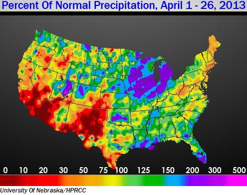
central Illinois and eastern Iowa have received from 200 percent to 400
percent of normal precipitation over the past 30 days," Murphy said.
While spring flooding is typical in the Midwest as snow cover melts and
heavy spring rainfall occurs, the recent extreme swings between record
dry conditions and record flooding are anything but normal. The swings
may be connected in part to climate change, since the atmosphere is now
carrying more moisture than it used to due to warming air and ocean
temperatures. Climate studies have projected that precipitation
extremes will become more frequent and severe. Some studies have
already found an increase in heavy precipitation events across the Northern Hemisphere and in North America, including in the Midwest..."
Photo credit above: "
Flooding on Grand Avenue in Chicago after heavy rains struck the city in mid-April." Credit: NWS via John Trillik.
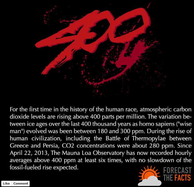
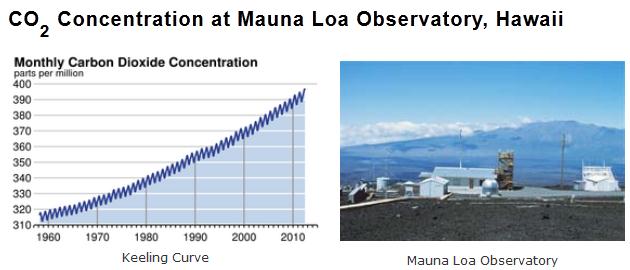
400 ppm. Graphic above courtesy of
Forecast The Facts.
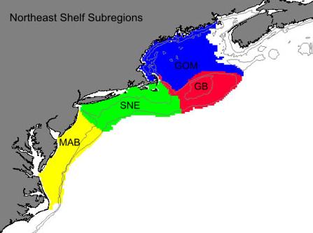
Sea Surface Temperatures Reach Highest Level In 150 Years Off On Northeast Continental Shelf. Potentially
record snows for the Upper Mississippi Valley while water temperatures
off the Northeast coast set new records. Very odd. Here's an excerpt
from NOAA's
Northeast Fisheries Science Center: "
Sea
surface temperatures in the Northeast Shelf Large Marine Ecosystem
during 2012 were the highest recorded in 150 years, according to the
latest Ecosystem Advisory issued by NOAA’s Northeast Fisheries Science
Center (NEFSC). These high sea surface temperatures (SSTs) are the
latest in a trend of above average temperature seen during the spring
and summer seasons, and part of a pattern of elevated temperatures
occurring in the Northwest Atlantic, but not seen elsewhere in the
ocean basin over the past century. The advisory reports on conditions in
the second half of 2012. Sea surface temperature for the Northeast
Shelf Ecosystem reached a record high of 14 degrees Celsius (57.2°F)
in 2012, exceeding the previous record high in 1951. Average SST has
typically been lower than 12.4 C (54.3 F) over the past three decades..."
To Fight Climate Change, Don't Mention It, Study Suggests.
Well that makes perfect sense. Lalalalala. The fact that going green
will save you money, help America conserve energy and become less
dependent on foreign countries that don't seem to like us very much are
all tangible benefits. Oh yeah - you might accidently do something good
for the environment. But keep that a secret. Here's a clip from
NBC News: "...
Those
who show a distaste for the environmental messages tend to side with
conservative political ideologies, according to the paper, which
teases apart how political views affect attitudes and choices when it
comes to energy-efficient products. "As expected, the more
conservative participants were, the less they favored investing in
energy-efficient technology," Gromet and colleagues write in the paper
published online Monday in the Proceedings of the National Academy of Sciences.
The ideological divide was strongest when energy efficiency was tied
to the environmental message of reducing carbon emissions. Energy
efficiency is more broadly appealing for the financial savings it
offers and for increasing energy independence..."
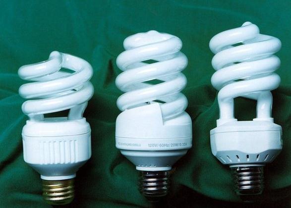
Photo credit above: "
Compact fluorescent light bulbs such
as those shown here are more energy efficient than incandescent bulbs.
To sell them broadly, new research suggests, skip mention of their
environmental benefits." Department of Energy Image.
1960s Satellite Images Add To Evidence Of Shrinking Sea Ice. Here's a clip from a story at NPR and
Georgia Public Broadcasting: "
Scientists
have digitized and analyzed imagery taken by one of the first U.S.
weather satellites to create a montage showing the extent of polar sea
ice in 1964 so they can compare it to more recent satellite photos. The images from low Earth orbit beamed down by the Nimbus I satellite
in 1964 reveal that Antarctic ice in September of that year was
"substantially higher" than estimates for the period 1979-2000,
according to the analysis published in the journal The Cryosphere..."
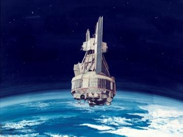
Image credit: "
An artist's rendering of the Nimbus 1".
Climate Change Is In The Air. Here's a segment from an article at
Clean Technica: "...
Another Republican, former Secretary of State George Shultz, is an unlikely climate activist who considers the issue urgent enough to warrant a recent visit to Capitol Hill
after a 20-year absence. His purpose? To push Congress to support
alternative energy sources. And Shultz is not alone. Even before 2012,
military leaders were expressing concern about climate change. In
February 2010, the Pentagon’s primary planning document identified
climate change and energy as “two key issues that will play a
significant role in shaping the future security environment” and went on
to note that “climate change, energy security, and economic stability
are inextricably linked.” In April of the same year, 33 retired generals and admirals wrote a letter to senate leaders warning that “Climate change is threatening America’s security” and urging action..."
U.S. Sociologist Tracks The Politics Of Climate Change. Here's a clip from a story at
UPI.com: ..."
But
there is still a political split on levels of perceived scientific
agreement, in that fewer Republicans and conservatives than Democrats
and liberals believe there is a scientific consensus." McCright say the
results of a Gallup survey of 1,024 adults asking their views on
climate change reaffirm the success of what he calls the "denial
machine" -- an organized movement to undercut the scientific reality of
climate change during the past two decades. The first step in dealing
with climate change, he said, is getting both sides of the political
spectrum to accept the scientific consensus. That would clear the way
for policymakers to undertake the task of coming up with an approach to
combat it, an effort that should involve both government and
industry, he said..."