“The adverse impacts of climate change are happening right now.
Climate change is not only ruining our summer, it is an indication of
longer-term consequences,” the report said. “Heat waves, warming water,
floods, droughts, wildfires and insect and pest infestations are the
new reality of an ever-warming world.” - excerpt from a story at The Hill, details below.
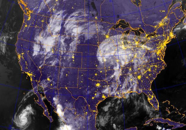
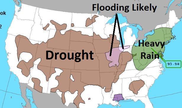
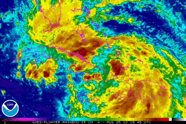
Soggy Swirl. The soggy remains of "Isaac" are
pushing north across the Mississippi River Valley, soaking Arkansas and
southern Missouri. Thursday evening IR image courtesy of the
Naval Research Lab.
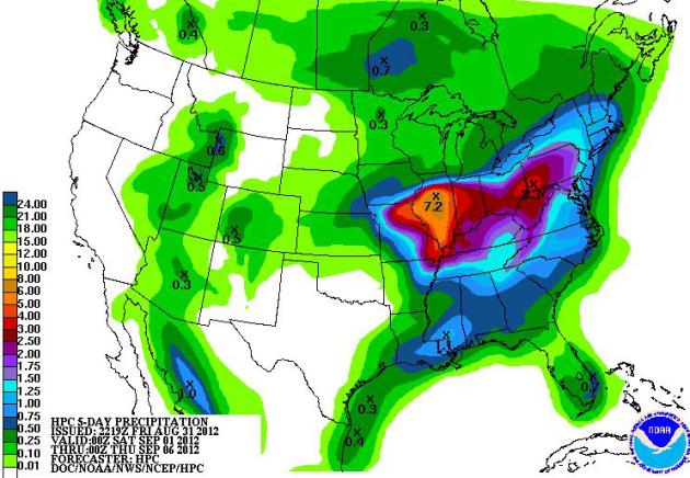
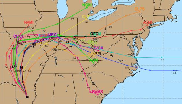
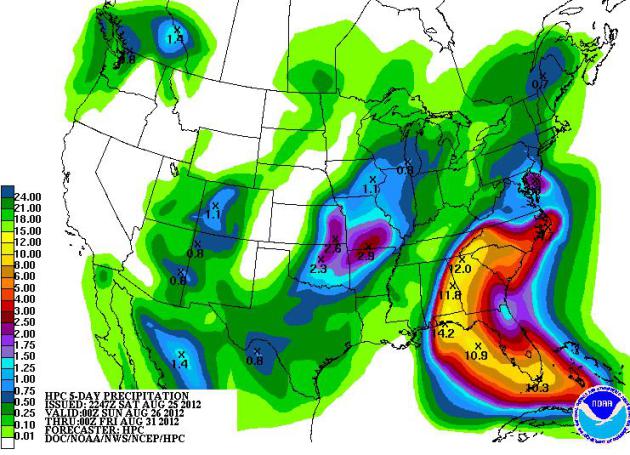
Isaac: A Drought-Denting Extra-Tropical Rainstorm.
The models are in pretty good agreement that what's left of Isaac will
push toward Kansas City and St. Louis, then veer east into Peoria and
Indianapolis, unleashing excessive rains on drought-parched counties
across the Midwest and Ohio River Valley. Rain is coming too late to
help farmers this year, but Isaac's soggy remnants may help to recharge
soil moisture and underground aquifers.
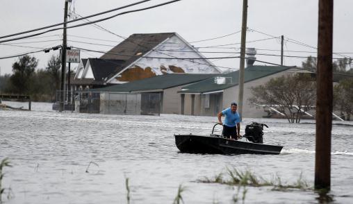
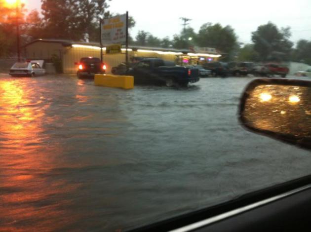
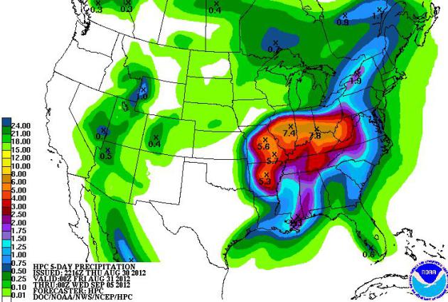
Instant Deluge. When you move to St. Louis,
Louisville or Cincinnati, the last thing you probably think about is a
washed-up hurricane washing out your Labor Day plans. NOAA HPC is
printing out some 4-8" rainfall amounts from Missouri to West Virginia
from Saturday into Monday of next week.
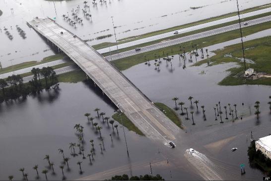
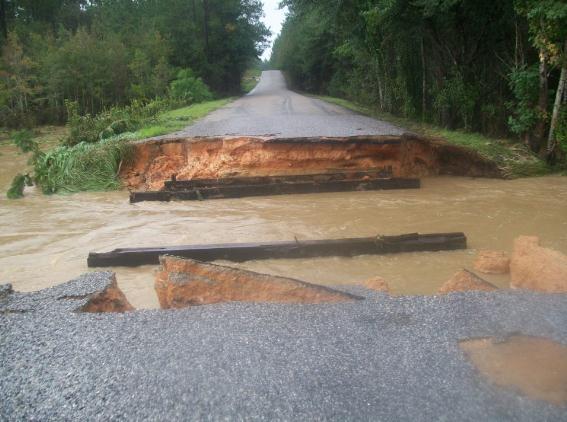
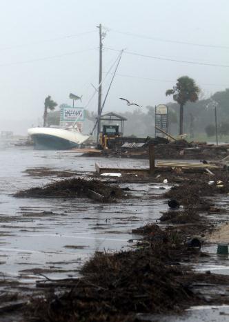
Washout! Here's what a tropical storm can do,
turning creeks into raging rivers, washing out highways from the sheer
force of moving water. Photo courtesy of
WKRG.
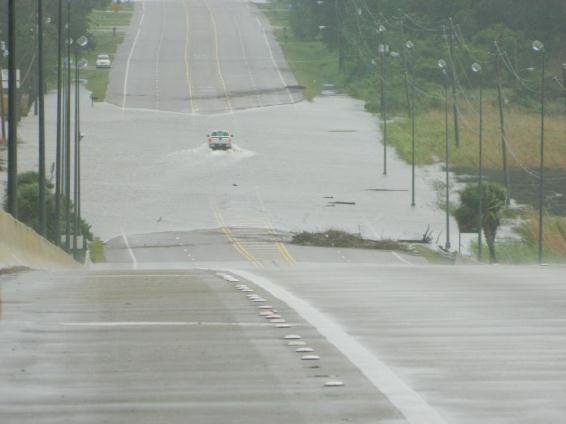
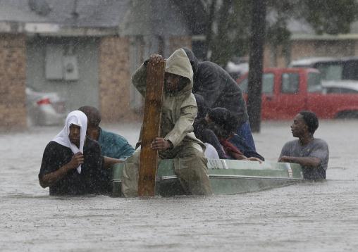
Not Recommended. This is how many people mee their
maker, crossing flooded-out roads. All it takes is 2 feet of
rapidly-moving water to turn your vehicle into a boat, with potentially
tragic consequences. As the NWS likes to say, "turn around, don't
drown!" Find a detour or stay put until waters recede. Thanks to Anna
Mills and
WeatherNation TV for passing on this pic taken near Mobile, Alabama.
Not Again. Although the new and improved ($14.5
billion) levee system protected metro New Orleans, the outlying parishes
didn't fair nearly as well, in fact in some areas flooding rivaled
Katrina, 7 years ago (almost to the day). Details: "
Residents
evacuate their flooded neighborhood, Thursday, Aug. 30, 2012, in
LaPlace, La. Isaac staggered toward central Louisiana early Thursday,
its weakening winds still potent enough to drive storm surge into
portions of the coast and the River Parishes between New Orleans and
Baton Rouge." (AP Photo/Eric Gay)
Isaac Headlines:
* Flooding areas north and south of New Orleans, and officials had
to scramble to evacuate and rescue people as waters quickly rose.
* Along the shores of Lake Pontchartrain near New Orleans, officials
sent scores of buses and dozens of high-water vehicles to help evacuate
about 3,000 people as rising waters lapped against houses and left
cars stranded
* Floodwaters rose waist-high in some neighborhoods, and the
Louisiana National Guard was working with sheriff’s deputies to rescue people stranded in their homes.
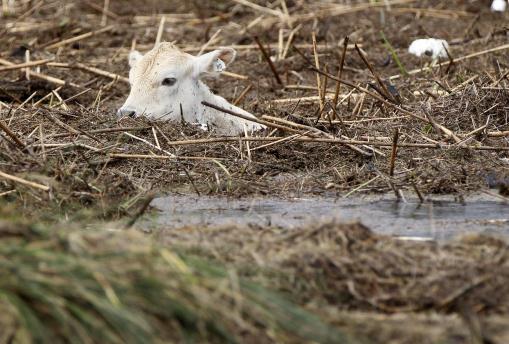
Severe Flooding. Details: "
A submerged cow is
stranded amid debris in floodwaters after Isaac passed through the
region, in Plaquemines Parish, La., Thursday, Aug. 30, 2012. Isac
staggered toward central Louisiana early Thursday, its weakening winds
still potent enough to drive storm surge into portions of the coast and
the River Parishes between New Orleans and Baton Rouge." (AP Photo/Gerald Herbert)
* The Louisiana
National Guard
ceased rescue operations in Plaquemines Parish, saying it felt
confident it had gotten everyone out. There were no serious injuries.
National Guard spokesman Capt. Lance Cagnolatti said guardsmen would stay in the area over the coming days to help.
* To the east, evacuations were ordered in a sparsely-populated area as a lake dam threatened to break near the
Mississippi-
Louisianaborder.
Officials in Tangipahoa Parish, La., feared the water it would pour
into the already swollen river would flood low-lying areas downstream.
Louisiana Gov.
Bobby Jindal said officials there would release water at the dam.
* The hardest-hit area was Plaquemines Parish, southeast of New
Orleans, where floodwaters overtopped at least one levee on Wednesday
and left many homes under about 12 feet of water.
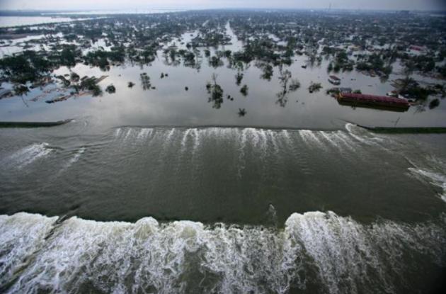
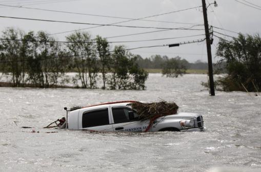
Entire Louisiana Parishes Submerged. Details: "
A
car sits submerged after Isaac passed through the region, in
Plaquemines Parish, La., Thursday, Aug. 30, 2012. Isaac staggered
toward central Louisiana early Thursday, its weakening winds still
potent enough to drive storm surge into portions of the coast and the
River Parishes between New Orleans and Baton Rouge." (AP Photo/Gerald Herbert)
* Parish President Billy Nungesser said U.S. Army National Guard
troops and local sheriff’s office officials were going house to house
through the area on Thursday to ensure that there were no deaths or
injuries.
* Clearing weather permitted the use of military helicopters, mostly UH-60 Blackhawks, to aid in the operation.
* In St. John the Baptist Parish, northwest of the city, about 3,000
people were forced to evacuate their homes before dawn on Thursday due
to storm surges from Lake Pontchartrain and Lake Maurepas, authorities
said.
* In Slidell, a town of about 27,000 people northeast of New Orleans,
storm surge from Lake Pontchartrain left the Eden Isle community under
about a foot of water.
* Emergency services rescued about 350 people from Slidell homes and
neighboring communities hit by more severe flooding, local authorities
said.
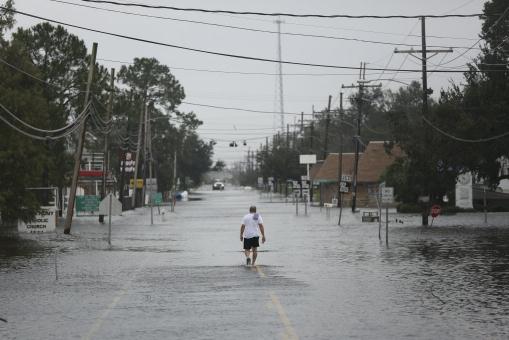
A Lonely Walk. Although downtown New Orleans dodged a
bullet with Isaac, surrounding suburbs (not protected by the new levee)
weren't nearly as lucky. Details: "
A man walks through floodwaters
from Tropical Storm Isaac in Jean Lafitte, La., Aug. 30, 2012. The
storm's once fierce winds slowed to 45 miles per hour on Thursday as it
moved out of southern Louisiana and headed north, continuing to bring
heavy rains and flooding." (Michael Appleton/The New York Times)
* Nearly half of
Louisianaelectrical customers lost power and another 150,000 were out in neighboring
Mississippi. Louisiana’s
Public Service Commission said 901,000 homes and businesses around the
state
— about 47 percent of all customers — were without power Thursday.
Utility company Entergy said that included about 157,000 in New Orleans.
* New Orleans’ biggest problems seemed to be downed power lines,
scattered tree limbs and minor flooding. One person was reported killed,
compared with 1,800 deaths from Katrina in Louisiana and
Mississippi.
* Multibillion-dollar defenses built to protect New Orleans itself,
after it was ravaged by Katrina almost exactly seven years ago, passed
their first major test, according to the U.S. Army Corps of Engineers.
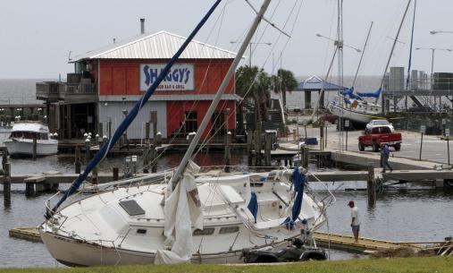
Storm Surge Aftermath. Tides rose 8-12 feet across
coastal Mississippi and Louisiana, and although water levels dropped
slightly today as Isaac's winds diminished, coastal areas remained
engulfed in water. Details:
"Debris lines the parking lot of the Pass Christian Harbor on Thursday, August 30, 2012." (Amanda McCoy/Biloxi Sun Herald/MCT)
* A Coast Guard helicopter hoisted a couple and their dogs early Thursday from a home in LaPlace, between the
Mississippi Riverand Lake Ponchartrain, The couple was taken to New Orleans and reported in good condition.
* The oil and gas industry in the Gulf of Mexico region has so far
reported no major storm-related damage to infrastructure. Energy
production was expected to start ramping up again, after nearly grinding
to a halt as Isaac closed in on Louisiana on Tuesday.
* President Barack Obama declared federal emergencies in Louisiana and
Mississippi late Wednesday, allowing federal aid to be freed up for affected areas.
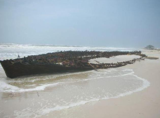
Mystery Ship Near Fort Morgan. Look what washed up
on the beach at Gulf Shores, Mississippi - whipped along by Isaac's
storm surge, wreckage of an old shipwreck. Details from Meyer Vacation
Rentals via
Facebook: "
Look
what Isaac uncovered! The first recent appearance of this mystery
ship, believed to have been a blockade runner during the Civil War, was
during Hurricane Ivan in 2004. In 2008, Hurricane Ike gave us a bigger
glimpse. And now in 2012, Hurricane Isaac is giving us a nearly full
view. Hmmm . . . 2004, 2008, 2012. All hurricanes with names beginning
with I. All within a couple of weeks on the calendar. While we hope it's
the end of the pattern, we must admit it sure is interesting to see it
appear!"
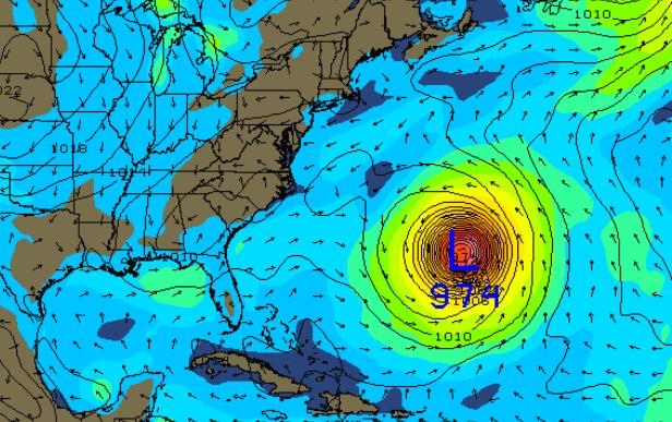
Hurricane Leslie? Still a tropical storm, "Leslie"
is forecast to become a hurricane, and then recurve to the
north/northwest, posing some risk to Bermuda. The map above shows a
strong Category 3 Hurricane Leslie next Friday, September 7. Odds are it
will stay out to sea, but an approaching trough of low pressure may
nudge Leslie farther to the northwest. New England will probably
experience strong swells from this major hurricane; right now the odds
of landfall over the USA are small, less than 1 in 10.
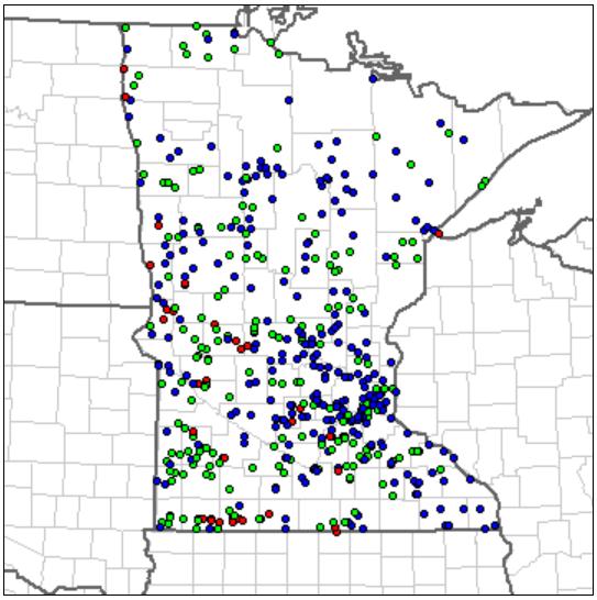
The Drought's Silver Lining: No Metro Tornadoes in 2012.
All those red dots (34 in all) are confirmed tornado touchdowns this
year, concentrated over western and southern Minnesota, but no
touchdowns within 50 miles of the Twin Cities. Duluth saw a
waterspout/tornado, only the second one on record for Duluth/Superior,
and the first since the 1950s! Map above courtesy of NOAA SPC.
Hurricane Isaac Drives Up Gas Prices. Could That Affect The Election? The Washington Post has the story; here's an excerpt: "
According to the U.S. Energy Information Administration, Isaac has forced
93 percent of oil production in the Gulf of Mexico to come to a halt.
That’s a loss of 1.3 million barrels daily of crude, about 22 percent
of all U.S. oil production. Five gasoline refineries in the Gulf and
four crude pipelines have also closed temporarily. It’s not surprising,
then, that gas prices are now jumping even higher,
to about $3.80 per gallon. Gas prices had already risen 40 cents per
gallon in the last two months after the United States tightened oil
sanctions against Iran and a refinery exploded in Venezuela. Isaac is
adding even new pressure. So, could these higher fuel prices sway the
November election?"
Severe Weather Warnings: Twitter, Text or TV? Here's an interesting story from
Information Week: "
NOAA
awarded four grants, worth a total of $879,000, in an attempt to
understand and improve the use of various media in delivering timely
information in a way that encourages people to take action to protect
themselves. The grants are in support of NOAA's Weather-Ready Nation
initiative. Experts from the agency's Storm Prediction Center,
National Severe Storms Laboratory, and weather and river forecast
centers will work with the award recipients. Twitter,
text, email, the Web, or traditional media--what's the best source of
information in the face of life-threatening weather conditions like Hurricane Isaac? The National Oceanographic and Atmospheric Administration has awarded four research grants to find out. "
Advanced Tornado/Hurricane Shelter Panels From Recycled Materials. Here's an interesting post from
Clean Technica: "
Researchers
from the University of Alabama at Birmingham have designed new storm
shelter panels made from recycled materials that have passed the
National Storm Shelter Association’s tornado threat test. The new panels
are a part of a new high-tech shelter they are designing."
Sony's 84" 4K TV In Stores By The End Of The Year.
HDTV is so 2005. According to Sony and other TV manufacturers it's
almost obsolete, because now there's 4K TV! They have to come up with a
better name though. Details from
gizmag.com; here's an excerpt: "
The
biggest announcement from Sony’s IFA press conference, if you’re going
purely by the size of the device, was the unveiling of its KD-84X9005
BRAVIA LCD TV. Packing an 84-inch LCD panel with 3,840 x 2,160 pixels
(that’s a total of 8.29 megapixels), the KD-84X9005 is Sony’s first 4K
television and outdoes Sharp’s AQUOS LC-90LE745U
in resolution, although not in size. In another first, the edge-lit
LED unit also features passive 3D instead of the active 3D seen in the
company’s previous 3D models."
* if you really have your heart set on a monstrous 145" 4K TV,
check this out. Only one small problem: there's no 4K content...yet.
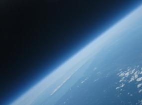
Galactic Service: Virgin Airlines Offers One Frequent Flier A Trip To Space.
It's pretty high up on my bucket list: seeing Earth (and weather) from
200 miles above the ground; at some point the prices will come down,
right? No time soon, I fear.
TechCrunch has the story; here's an excerpt: "
Virgin
America is one of my favorite airlines to fly on — it’s kind of like
the airline of the future, with interactive displays in every headrest,
cool lighting, an animated safety video, and there’s almost always
WiFi on board. But Virgin is looking to be even more futuristic,
promising the customer with the most miles at the end of the year a
chance to upgrade to Galactic status. That’s right, the person who flew
the most on Virgin Airlines will win a ride to space courtesy of
Richard Branson’s Virgin Galactic. Starting now through August 7, 2013, the contest will allow the most frequent flier to take a trip on Virgin Galactic’s SpaceShipTwo, a carbon composite commercial space craft."
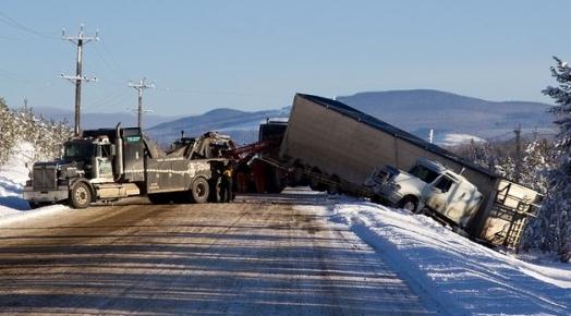
Experimental Device May Keep Trucks From Jack-Knifing. Technology will save us! Maybe not, but I found this entry from
gizmag.com interesting: "
If
there’s one thing that truck drivers don’t want their articulated
tractor/trailer rigs to do, it’s jack-knifing. This typically occurs
when the tractor skids on the road, and the momentum of the trailer
causes it to swing out from behind, ultimately resulting in the tractor
and trailer being folded up against one another – not unlike a jack
knife’s body and blade. The folded rig usually ends up blocking the
road, and the tractor can’t undo the situation under its own power.
Fortunately, Greek researchers have recently created a system that they
claim could greatly reduce jack-knifing."
3rd Hottest Summer
You just enjoyed/endured the 3rd hottest summer
on record. Only 1988 and 1933 were a fraction of a degree hotter,
according to Pete Boulay, at the climate office. 28 days of 90+. Average
is 13. Two days of 100+, the most since 1988. Based on NWS cooling
degree data we've used 45 percent more electricity to cool our homes.
Ouch.
July was rough, but records show 177 hours of drippy, 70+ dew points. Average for the summer season is 180 hours.
A stubborn heat-pump high nudged the jet stream
500 miles farther north; severe storms detouring over Canada. No metro
tornadoes in 2012, but Duluth saw the second (weak, EF-0) tornado in
it's history! That, and a 1 in 500 year flood. Very odd.
Yes, it's been hot, and a brewing El Nino may
tip the scales in favor of another milder winter. But snow lovers should
keep the faith. 1988 was a scorcher, but MSP picked up 25 inches of
snow between October and December of that year.
Here's some fun party trivia: the first flurries up north are about 30 days away, on average.
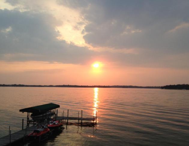
Warm sun prevails into Labor Day; a 1 in 3
chance of a brief Monday shower. Soak up the heat because jacket weather
is brewing for late next week.
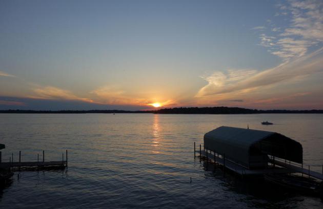
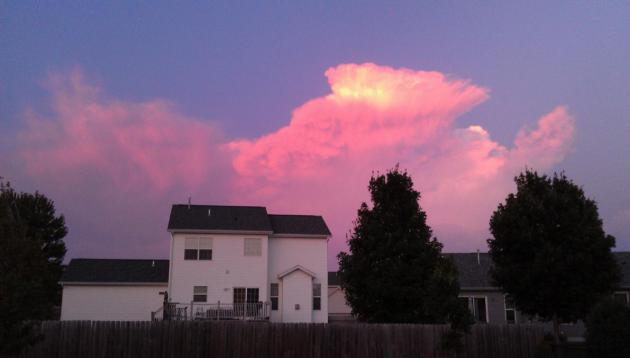
Summer's last hurrah?
Climate Stories....
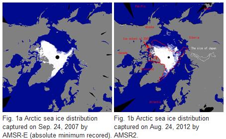
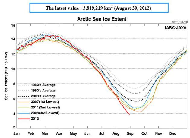
A New Record Minimum Of The Arctic Sea Ice Extent.
More details on the new record for ice loss at the top of the world,
smashing the old record set in 2007. Here's an excerpt from
JAXA, the Japan Aerospace Exploration Agency: "
Melt
season in the Arctic Ocean came in the summer of 2012. The Arctic sea
ice is shrinking at an unprecedented rate this year and set a record
minimum. A record minimum sea-ice coverage of 4.21 million sq km was
observed by satellite on 24 August 2012, one month earlier than
previous minimum record set on 24 September, 2007."
Arctic Collapse Dramatically Increases Global Warming.
It's a feedback effect, less ice results in a darker albedo (ocean
water absorbs more infrared radiation than ice), which causes more
warming, which melts more ice, which causes more warming, etc. A domino
effect. Here's an excerpt of an article at
The University of Manchester: "
Writing in Nature, the scientists, led by Stockholm University,
discovered that much more greenhouse gas is being released into the
atmosphere than previously calculated, from and ancient an large carbon
pool held in a permafrost along the 7,000 km desolate coast of
northernmost Siberian Arctic – dramatically increasing global warming.
As the temperature climbs carbon, stored in vast ice walls along this
Arctic coast called Yedoma, covering about one million km2 (four times
the area of the UK), is pouring into the Arctic Ocean in one of the
world’s most remote and desolate regions.
This region is experiencing twice the global average of climate
warming. While satellite images reveal thousands of kilometers of
milky-cloudy waters along the Arctic coast, suggesting a massive influx
of material, the Yedoma has remained understudied largely due to the
region’s inaccessibility. By studying the thaw-eroding slopes of a
disappearing island, the team found that the tens-of-thousands year old
coastal Yedoma carbon is rapidly converted to CO2 and methane, even
before being washed into the sea."
Graph above courtesy of the
Arctic Sea-Ice Monitor.
Report: Climate Change Promises More Tough Summers. Here's an excerpt of a story at
The Hill: "...
While
it is difficult to point to any one specific weather incident as the
result of human activity, the report said the abundance of abnormal
conditions indicate climate change is a reality. NWF said the nation
must adopt more solar, wind, geothermal and biomass energy to stunt
climate change. “The adverse impacts of climate change are happening
right now. Climate change is not only ruining our summer, it is an
indication of longer-term consequences,” the report said. “Heat waves,
warming water, floods, droughts, wildfires and insect and pest
infestations are the new reality of an ever-warming world.” Despite
record temperatures, crippling drought and raging wildfires this
summer, President Obama and GOP presidential nominee Mitt Romney have
avoided talking about climate change on the campaign trail."
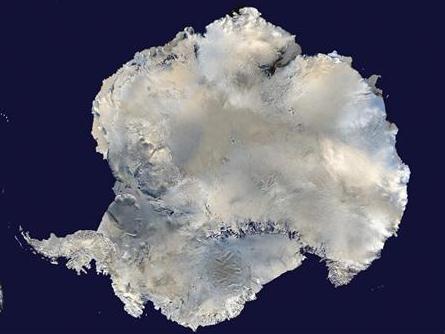
Antarctic Methane Could Worsen Global Warming: Scientists. Here's a snippet of a
Reuters story: "
Large
volumes of the greenhouse gas methane could have been produced under
the Antarctic Ice Sheet over millions of years, which could add to
global warming if released into the atmosphere by a thaw, a study said
on Wednesday. Scientists
from the universities of Bristol, Utrecht, California and Alberta
simulated the accumulation of methane in Antarctic sedimentary basins
using models and calculations. They
found it was likely there were micro-organisms there that would have
been able to convert the ice sheet's large deposits of organic carbon
into the potent gas. If present, methane would most likely be trapped under the ice."
The Cultural Divide Over Climate Change. Once again Doug Craig at
redding.com
posted a thoughtful article that nails the problem: beyond using
climate change as an ideological and political football, there is a
problem related to science literacy in the USA; here's an excerpt: "
Andrew Hoffman recently wrote a piece for the Stanford Social Innovation Review
in which he argued that a scientific consensus on climate change is
irrelevant if we cannot attain a social consensus on this critical
concern. We are too divided culturally and politically to establish a
common ground. One reason, Hoffman suggests for this sorry predicament
is scientific illiteracy. "With upwards of two-thirds of
Americans not clearly understanding science or the scientific process
and fewer able to pass even a basic scientific literacy test, according
to a 2009 California Academy of Sciences survey, we are left to
wonder: How do people interpret and validate the opinions of the
scientific community? The answers to this question can be found, not
from the physical sciences, but from the social science disciplines of
psychology, sociology, anthropology, and others."
Common Sense And Global Warming. Here's a portion of an Op-Ed at
jacksonville.com: "...
What
do we do about it? The transition from coal to natural gas is a help.
Nuclear power can provide a bridge, at the very least maintaining its
share of the American power supply. A move to more efficient cars will
help. Any changes must be phased in so that they do not hurt the
economy. The best solutions would stimulate the economy and create jobs
while combating global warming."


