Monday, December 31, 2012

January 1st: Happy New Year! Cold Start to 2013!

A True Minnesotan
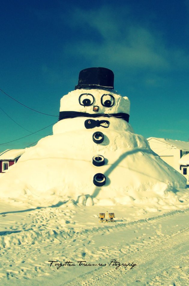
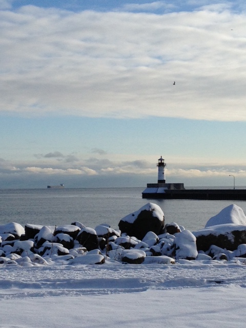
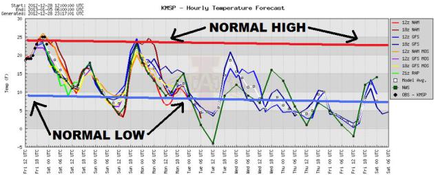
Thanks to @Brentyyyyyyyy for the picture below out of Minneapolis, MN. Now this is my definition of a perfect day! Can't beat an outdoor rink day.


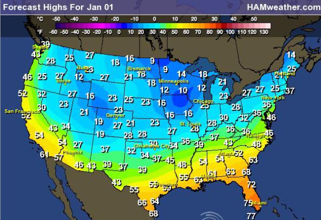
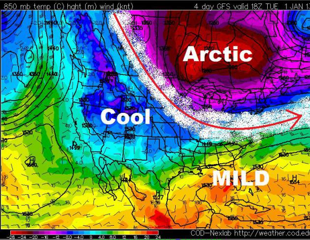
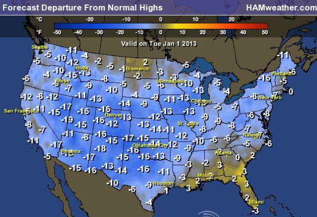
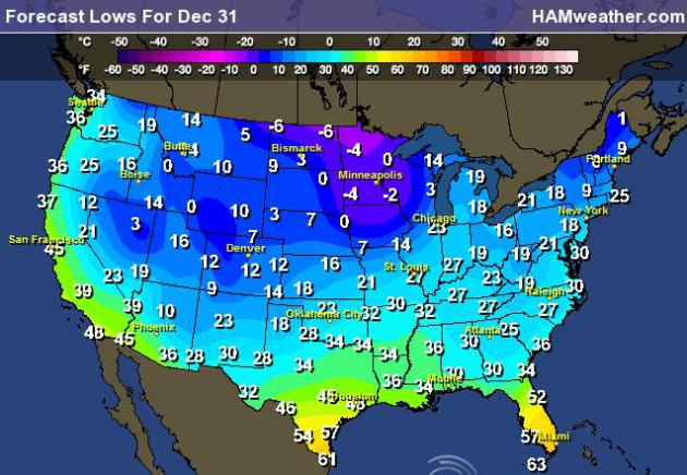
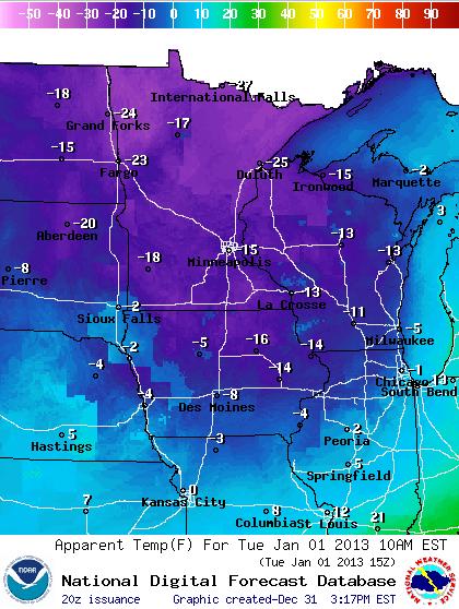
Cold into the New Year
Take a look at the map below from the NWS. It shows the apparent temperature (feels like or wind chill) around 9am CST. Wind chills are still expected to be in the sub-zero range through the late morning hours. Other that some of the Mountain West locations, these will be some of the coldest readings across the entire Lower 48.


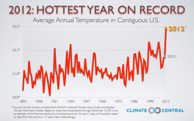
2012 Warmest Year on Record for U.S.
You're living weather history... Can you believe that we just endured the warmest year on record for the U.S.? Temperatures didn't just break the record, but it SMASHED the record!
"By taking the top spot as the hottest year in the U.S., 2012 pushes 1998 into second place, followed by 2006, 1934 and 1999. In line with the global warming trend spurred by steadily rising carbon emissions, seven of the top 10 warmest years in the 48 states have occurred in the past 15 years.
Like so much recent record-breaking weather, 2012 isn’t just going to break the previous record, 2012 is looking to smash it, by more than 1°F. Climate Central projects the 2012 average temperature for the continental U.S. at 55.34°F compared to the previous record set in 1998 of 54.32°F. For perspective, 1°F is one quarter of the difference between the coldest and warmest years ever recorded in the continental U.S." 

Read more from  climatecentral.org HERE:


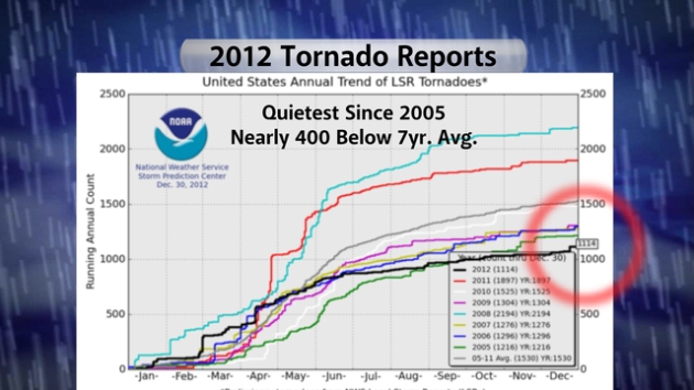
Extreme Heat Hampered 2012 Tornado Production
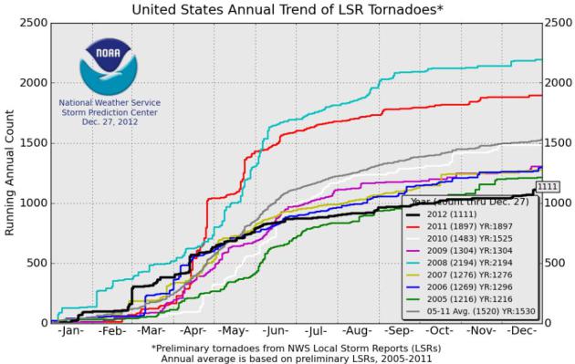
Interestingly, the extreme heat played a role in the amount of tornadoes across the nation this year. Because it got so hot so fast this spring, we didn't really see any extended tornado risks. According to the Storm Prediction Center, the 2012 tornado count will finish nearly 400 reports less than the 7year average.


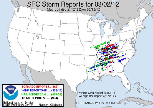
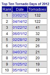
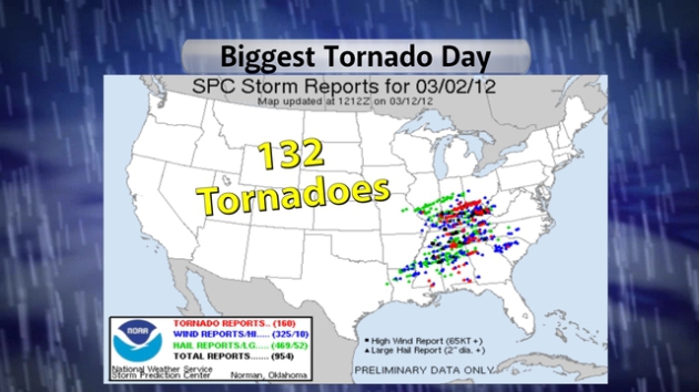
2012's Biggest Tornado Day
2012's biggest tornado day was on March 2nd. There were 132 tornadoes from the Ohio valley to the Gulf Coast. March tornadoes also claimed the lives of 41 this year; (68 total fatalities for the year).


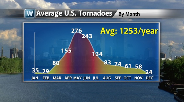
Average Tornadoes by Month Across the Nation (1991-2010)
According to NOAA's NCDC, the graph below suggest the average number of tornadoes across the nation by month. Note that our most active month is May with 276. Our most active month this year was April with 233 tornado reports, followed closely by March at 225. Both of these months ran above average because of the rapid warm up we had so early in the season, which can also be attributed on the lack of snow pack during last winter. 2012's 1,114 tornado reports are also below the average 1,253/year shown below.


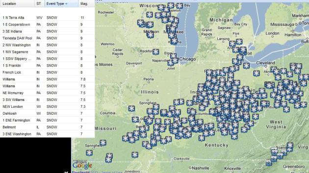
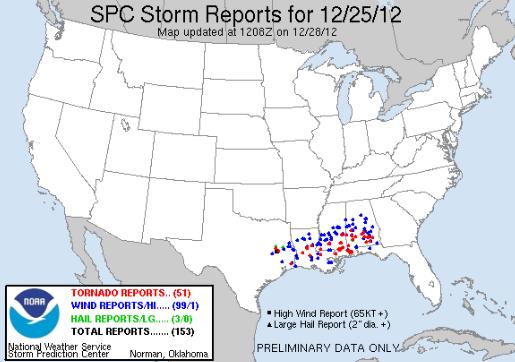
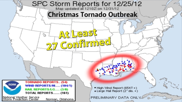
Record Christmas Day Tornado Outbreak
There have been AT LEAST 27 confirmed tornadoes from the Christmas Day tornado outbreak last week. This will go down in history as the most tornadoes ever recorded on Christmas Day.


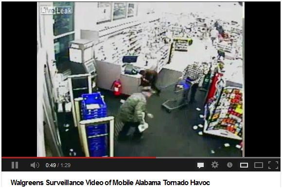
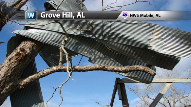
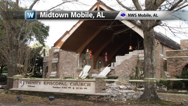
Extensive Damage and Fatalities
Cleanup from the strong Christmas Day tornadoes will take weeks and months. Here are some of the damage pictures from the National Weather Service out of Mobile, AL where EF-2 was reported.


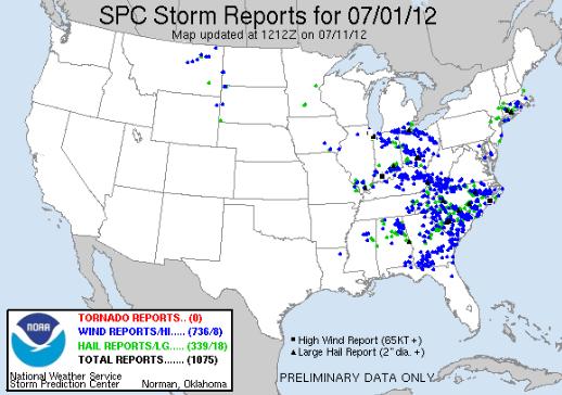
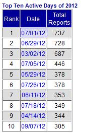
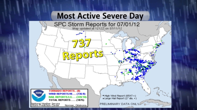
2012's Biggest Severe Weather Day
Because of the excessive heat across the middle part of the nation this summer, we had several days that produced long-lived straight line wind producing storms. July 1st, 2012 produced over 700 severe weather reports (mostly damaging wind reports). These storms lasted several hours and crossed many states.


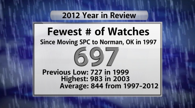
2012 Sees Fewest Severe Watches Since 1997
I knew the severe weather was fairly quiet this year, but I didn't know it was this quiet!
"The year will finish without any severe storms forecast during the next several days, so we offer this trivia tidbit regarding SPC watches. Did you know that 2012 will have the fewest number of tornado and severe thunderstorm watches issued by SPC since moving to Norman in 1997? Just 697 watches were issued this year (two numbers were inadvertently skipped which is why the last watch issued was #699). This breaks the previous record low (since SPC has been located in Norman) of 727 in 1999. The average number of watches per year for 1997-2012: 844. The greatest number of watches in a year during that time span: 983 in 2003."
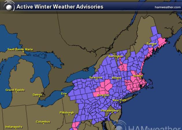
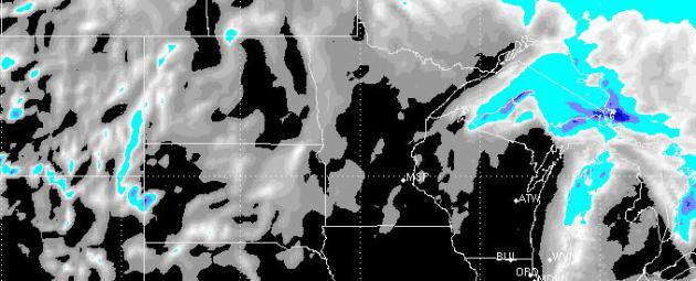


Wednesday Clipper
A moisture-starved clipper system will drop into the Lower 48 with scattered light snow showers. I don't see much accumulation potential with this; a light coating is all.


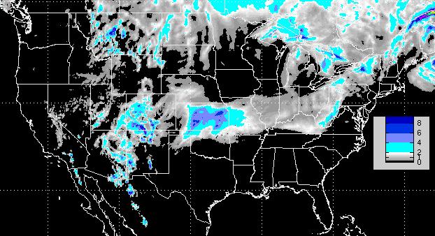
Snow Potential Through Midday Thursday
Here's the snow forecast with next clipper system. Again, it doesn't look like much here. Hardly enough to fire up the snowblower unless you're downwind of the Great Lakes. 


Thanks for checking in, have a great 2013 ahead!
Don't forget to follow me on Twitter @TNelsonWNTV


Sunday, December 30, 2012

December 31st: Turning into Frozen Pumpkins at the Stroke of Midnight


Champion, NY
Thanks to Forgotten Treasures Photography for the picture below. It's a monsterous snowman out of Champion, NY.


North Platte, NE
Thanks to @Hansen_77 for the beautiful sunset picture below out of North Platte, NE.


Marquette, MI
Thanks to Greg Kretovic for the picture below out of Marquette, MI during some recent lake effect snow.


The Big Ball Drop
New York City will be abuzz today/tonight with people looking for the best spot to ring in the new year. It'll be a little chilly, but festive with a chance of light snow around midnight.
Here's a look at all the events for New Year's from timessquarenyc.org HERE:


Festive Forecast
The forecast for the big event looks a bit cool, but also fairly festive! Look for a little light snow as countdown continues. Here's a look at the NYC forecast from the WeatherNation app available on Itunes. 


Shovelable Snow Event For Some
The next winter event will move across the mid-section of the nation today with shovelable snow potential for some. Winter Weather Advisories have been posted from the Texas Panhandle to the Ohio Valley with 2" to 4" possible and isolated 6" amounts possible as well.


Snowfall Forecast
This is a look the RPM snowfall forecast through midday Wednesday, note the heavier tallies around central/eastern Kansas with up to around 6" possible in spots.


Cold Into the New Year
Here's a look at the forecast lows across the nation New Year's Eve... Brr!


Cold Highs New Year's Day
It definitely looks cold into the New Year. Here are the forecast high temperatures for Tuesday, January 1st. Temperatures across the nation will be running several degrees below normal for many locations.


Highs From Normal on January 1st
Here are the highs from normal across the nation on Tuesday, note that most locations other than the southeast will be well below average temperatures for the first of the year.


Thanks for checking in and have a great rest of 2012 and New Year ahead!
Don't forget to follow me on Twitter @TNelsonWNTV


Saturday, December 29, 2012

December 30th: Snow Lingers in the Northeast, More Snow on the Way by New Year's

Guntersville, AL
Thanks to @MainStormTower for the picture below out of Gunterville, AL


Duluth, MN
Thanks to my good friend Wanda Brandt for the picture below from Duluth, MN


Denali National Park, AK
Thanks to the Denali National Park, AK Facebook page for the picture below of the last full moon of 2012.


Noblesville, IN
Thanks to @samlgookins for the picture below of heavy snow falling in Noblesville, IN from this weekend's snow event across the Ohio Valley.


Ohio Valley Snow Totals
Here are some of the highest snow tallies I could find from across the Ohio Valley.


More Snow in the Northeast
The image below shows all the winter headlines through AM Sunday. Snow totals of up to 12" are possible in localized areas!


Northeast Snow Totals Thru Sunday
The RPM model suggests shovelable snow amounts for many in the Northeast through Sunday. The storm will deposit several inches of snow across parts of Maine.

Lingering NE Snow on Sunday
Here's the weather map around midday Sunday. Lingering snow showers/flurries along with breezy northwesterly winds will allow for blowing and drifting snow through much of the day Sunday. There may even be a few lingering flight delays early Sunday.
More Snow on the Way
There another storm developing across the mid-section of the nation will have more shovelable snow potential for folks from Kansas to the Eastern Great Lakes by early next week. The NAM forecast brings up to 6" possible around the Kansas City, MO area around the New Year. This forecast CAN and WILL change... stay tuned!
COLD New Year's Forecast
It definitely looks like winter into the New Year. The extended forecast calls for a big Arctic blog to set up over the Hudson Bay through next week. Waves of this modified Arctic air will settle south of the international border by way of moisture starved clipper systems.

Highs on New Year's Day


Highs From Normal on Tuesday
Take a look at how much colder than average high temperatures will be on Tuesday.


 Thanks for checking in, have a great rest of you weekend!
Don't forget to follow me on Twitter @TNelsonWNTV

Friday, December 28, 2012

Much Colder End of the Year; Storm Track Active From Texas to New England

More on Christmas Tornado Outbreak
 
Take a look at this surviellance video from a Walgreens store out of Mobile, AL during the Christmas tornado outbreak. I'm SHOCKED that there weren't as many fatalities as there could have been.


Updated Christmas Day Tornado Count
The Storm Prediction Center continues to update the tornado tally from the Christmas Day outbreak. The unfiltered PRELIMINARY reports are now up to 51!
"Nationwide, at least 17 people died because of the ice, snow and wind. Deaths from wind-toppled trees also were reported in Texas and Louisiana, but car crashes caused most of the fatalities."


2012 Tornado Count
Despite the recent flurry of tornado activity, 2012 will end well below the average annual tornado count. According to the SPC, as of December 27th, there were 1,111 tornado reports nearly 400 below the 7year average of 1530.


Top 10 Tornado Days of 2012
The Storm Prediction Center has a list of the top 10 tornado days of 2012... the most active days was March 2nd when 160 tornadoes were reported (actual 132).


Most Active Severe Weather Days of 2012
The information below from the SPC shows the top 10 most active severe weather days of 2012. Preliminary data from July 1st, 2012 had over 1,000 storm reports, a number that was refined to 737. Intense heat across the mid-section of the nation allowed for severe thunderstorms to develop on its northern periphery. These thunderstorms created long lived straight-line wind producing storms. Look at all the wind damage reports (in blue) from the Great Lakes to Florida! The other BIG day was June 29th.


Canada Blizzard
I thought this was kind of neat, it's a time lapse of a blizzard out of Montreal Canada, which is north of Burlington, VT. This is from the same storm system that produced snow in Texas and the tornado outbreak earlier this week.


Air Travel Troubles?
Another winter storm/system is bearing down on the Northeast through the early weekend. It appears snow amounts won't be quite as dramatic as they were this last week, but this will still be responsible for some travel troubles. The graphic below shows the winter weather headlines that have been posted through the weekend.


Northeast Snow Forecast
According to the RPM model, there is going to be a moderate swath of 2" to 4" with localized areas of 4" to 8" through the weekend.


Saturday Outlook
Here's the weather map for PM Saturday, which shows the center of circulation south of New York, but there will be decent wind and snow across some busy places that may be more than just an inconvenience tro travelers. Moderate to heavy snow totals along with wind gusts close to 30mph will create problems on the ground and by air.


Cold Start to 2013
 
The forecast calls for a fairly cold star to 2013. Thanks to a big dip in the jet stream, cold air from the Arctic regions will continue to refrigerate much of the Lower 48 through the early part of 2013.


Cold Start to 2013
 
The extended forecast calls for a fairly cold start to 2013 across much of the nation. Here's a look at the high temperature from normal forecast for Tuesday, January 1st, 2013... Brr!


Ringing in the New Year
 
If you have plans to be out and about through New Year's Eve night, take a look at the forecast low temperatures for the night... Brr again! Make sure to bring the extra layer along to the ball, you'll need it after the clock strikes midnight otherwise you'll turn into a frozen pumpkin!


Below Normal Temps
 
The extended forecast for Minneapolis calls for generally below normal temps from the end of December through the first part of January. Temperature may consistently bottom out near the sub-zero mark.
 
 
Latest Snow Reports
 
Here's a list of the latest snow reports from Thursday-Friday. Even though there wasn't much moisture with this system, cold temperatures allowed the snow to really fluff up! Reports of 1" to 3" across the Twin Cities was pretty common.


Thanks for checking in and have a great weekend ahead!
 
Don't forget to follow me on Twitter @TNelsonWNTV