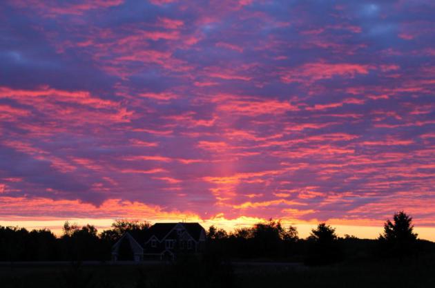
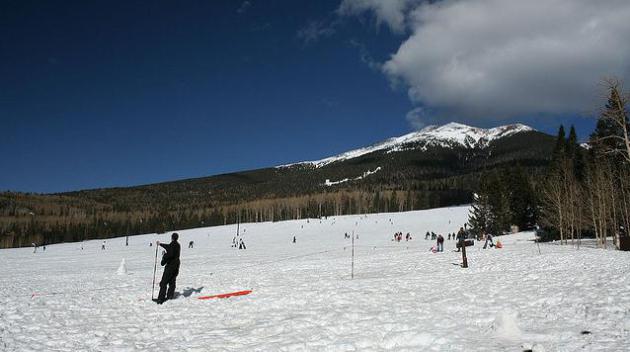
"A Dry Heat". My friends in Scottsdale, Arizona
love to remind me that "Paul, it's a dry heat!" So is my oven, but I
still wouldn't stick my head inside. Walt Kruhoeffer snapped this pic of
Lake Calhoun Saturday as the mercury was topping 80. Is it me or does
everything look extra-dry out there?
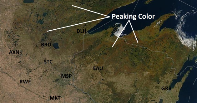
Drought - And Peak Color From Space. NASA's high-resolution
MODIS satellite image
from Saturday shows tinges of orange and red from low orbit. From 200
miles up you can see how dry much of Minnesota is right now.
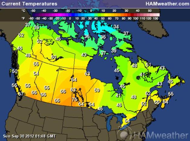
Unseasonable Warmth Sweeps Across Canada. From
Calgary to Winnipeg, Canadians are rubbing their eyes, wondering what
month it is. The map above shows temperatures as of 9 pm Saturday
evening. Colder air will push southward by midweek, setting the stage
for a little wind chill, even flurries up north within a week.
Yep...flurries. Map above:
Ham Weather.
Flurry Potential By Next Sunday?. With 850 mb
temperatures (about 4,000 feet above the ground) forecast to be in the
23-28 F range a week from today I wouldn't be surprised to see flurries,
even a few heavier snow showers over central and northern Minnesota.
With surface temperatures falling thru the 30s up north I wouldn't even
be surprised to see a little slush north of Brainerd Sunday night.
Lovely. Map above: WSI Corporation.
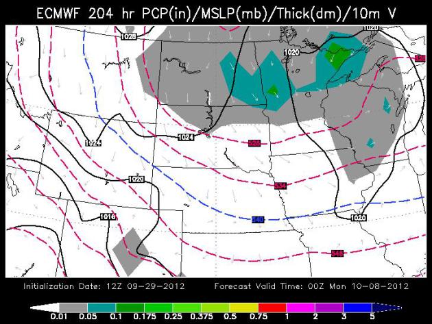
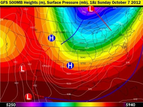
Looks Like October. The GFS 500 mb (18,000 foot)
forecast valid next Sunday at 1 pm shows a cold, deep trough of low
pressure centered over Hudson Bay, reinforcing "spokes" of energy
rotating around this cold whirlpool of Canadian air. By next Sunday
temperatures aloft may be marginally cold enough for a few wet flakes to
reach the ground up north.
Map above courtesy of Larry Cosgrove's
WeatherAmerica Newsletter.
In Case You Were Wondering....
PUBLIC INFORMATION STATEMENT
NATIONAL WEATHER SERVICE TWIN CITIES/CHANHASSEN MN
1045 AM CDT SAT SEP 29 2012

...FROST AND FREEZE HEADLINES HAVE CEASED FOR THE FALL SEASON...

IN COORDINATION WITH SURROUNDING OFFICES AND LOCAL AGRICULTURAL
SPECIALISTS...IT HAS BEEN DETERMINED THE GROWING SEASON HAS ENDED
ACROSS MUCH OF THE AREA DUE TO EARLIER FROSTS AND FREEZES.
THUS...FROST ADVISORIES AND FREEZE WARNINGS WILL NO LONGER BE ISSUED
UNTIL THE GROWING SEASON BEGINS AGAIN IN SPRING 2013.
Frost/Freeze possible Saturday morning, even for the close-in suburbs.
October 4. Mean date of the first 32-degree temperature in the Twin Cities. Source:
MN Climate Office.
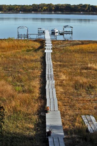
The Amazing, Shrinking White Bear Lake. What
happened to White Bear Lake? The photos are a stark reminder of what's
happening statewide: lake water levels are down 2-5 feet, but the
problem is much worse on White Bear: "
White Bear Lake is plummeting
to a record low water level due to the current drought and large amount
of groundwater pumping. Some lakeshore property owners have had to
constantly expand their docks to reach water's edge." (MARLIN LEVISON/STARTRIBUNE).
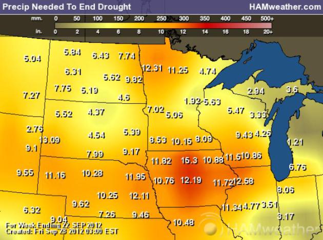
Rainfall Necessary To End The Drought. Based on
NOAA's Palmer Index, the values above are the rainfall amounts necessary
to end the drought. Those amounts range from 5-6" in the Twin Cities
metro to 8-11" over southern counties, to as much as 11-13" over the Red
River Valley. A couple of storms won't do the trick - it may take many
months to dig ourselves out of this dry, dusty hole. Map: NOAA, USDA and
Ham Weather.
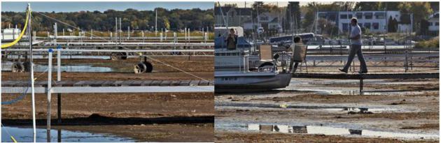
Good News For Dock Companies. Good grief - look at the collection of extendable docks on White Bear Lake. Details: "
White
Bear Lake is plummeting to a record low water level due to the current
drought and large amount of groundwater pumping. Docks along the
shoreline need to be constantly extended." (MARLIN LEVISON/STARTRIBUNE).
Groundwater Blamed In White Bear Lake Drop.
The Freshwater Society has a comprehensive article focused on some of the possible triggers of water loss in White Bear Lake; here's an excerpt: "
The
research, funded by the USGS, the state and a number of local
governmental units, reinforced some old theories and produced some new
evidence about the causes of the lake’s decline. The findings so far:
- White Bear drains a very small watershed and has always had
big decreases in area and volume during extended dry periods when
rainfall and melting snow do not keep up with evaporation.
- Chemical testing of water from wells around the lakes
confirms that lake water is flowing out the bottom of the lake into
groundwater aquifers that feed those wells.
- Pumping from high-capacity wells in suburban communities
that mostly draw their water from those aquifers more than doubled over
the last 30 years.
Statistical modeling suggests that the increased pumping is the
biggest cause, by far, of the lake’s decline, according to Perry Jones,
the USGS hydrologist who led the research. Other modeling predicts the
lake will drop further if there is no significant and sustained
increase in precipitation."
331 months. Setpember is the 331st month in a row
where the global temperature exceeded the 20th century average. Source:
NASA GISS.
"...In total over 35 percent of Minnesota's landscape was
designated to be in severe or extreme drought, the largest fraction of
the state since the fall of 2006. The only Minnesota county not
designated to be drier than normal is Cook in the far northeast." - from Dr. Mark Seeley's WeatherTalk blog; details and links below.
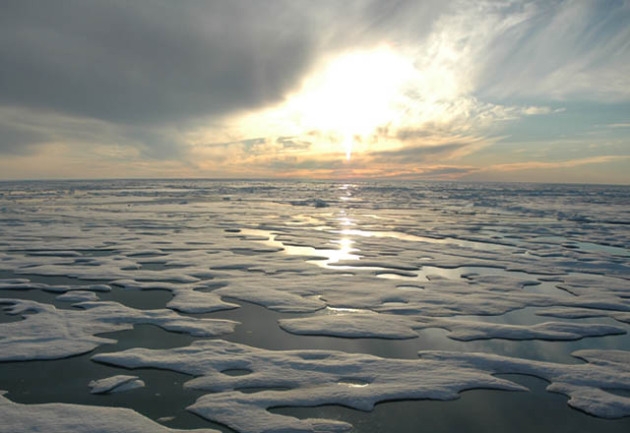
"
Noted sea ice geophysicist and climatologist Professor John Yackel from
the University of Calgary has delivered a bombshell: He recently
declared after the latest Arctic ice melt that, "This is the smallest
minimum ice extent we've ever had, and not just in the satellite record,
but probably in the last million years." - excerpt from a San Francisco examiner.com article; details and links below. Photo above: NOAA.
"...
Up to 80 per cent of the global warming of the planet has
been to warm the world's oceans. The Southern Ocean is warming much
more rapidly than other oceans. Warm ocean currents undermine ice
shelves and can speed up glaciers and ice streams, having a far
reaching effect at thinning glacier catchments of the est Antarctic and
East Antarctic Ice sheets far inland." - from a post at Indybay.com; details and links below.
One Of The Driest Septembers On Record. Actually,
it's the second driest September in modern-day records dating back to
1891, the driest since 1882 for MSP. Here's an excerpt of this week's
WeatherTalk blog post from Dr. Mark Seeley: "...
The
real story for September was the dryness due to absence of rainfall.
Many observers reported measurable rainfall amounts on only 2-3 days,
resulting in one of the driest Septembers in history on a statewide
basis. The driest September was 1952 when the statewide average
rainfall was just 0.57 inches. This year's statewide value will be
close to that one. Many observers clearly reported their driest
September in history, including Windom (0.30"), Moorhead (0.19"),
Willmar (0.14"), Collegeville (0.08"), and Morris (0.03"). For Morris
and Collegeville it was one of their driest months in history as well.....
As
of the end of September the U.S. Drought Monitor placed all or parts
of 45 Minnesota counties in severe to extreme drought, most notably in
southwestern, south-central and northwestern Minnesota."
Photo credit above: "
White Bear Lake is plummeting to a
record low water level due to the current drought and large amount of
groundwater pumping. Some lakeshore property owners have had to
constantly expand their docks to reach water's edge." (MARLIN LEVISON/STARTRIBUNE).
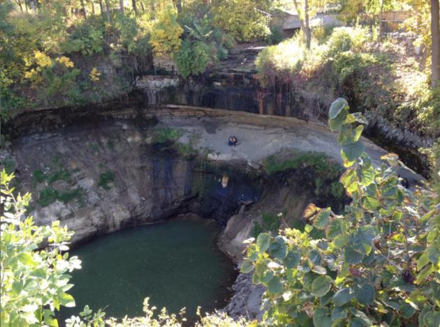
More Sinkhole Than Waterfall. That's a photo of
Minnehaha "Falls" taken by WeatherNation TV meteorologist Addison Green
on Thursday. Not even a trickle of water. Not good.
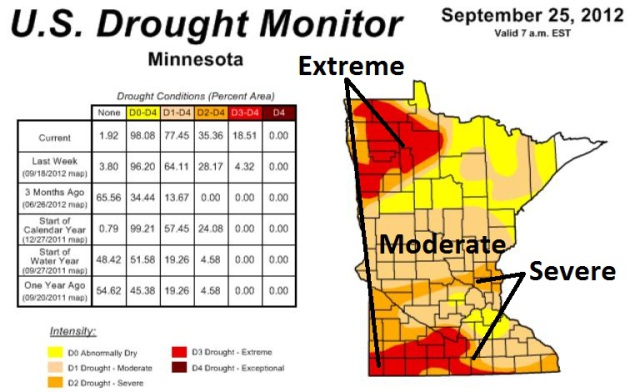
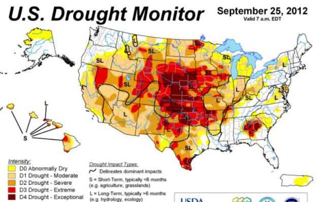
Minnesota's Drought Deepens. The latest
U.S. Drought Monitor
shows 98.08% of the Gopher State is now "abnormally dry", 77.45% of
Minnesota in moderate drought - severe drought now pushing across
central Minnesota into the northern suburbs of the Twin Cities. Extreme
drought is expanding across far southern Minnesota and much of the Red
River Valley. We started the year in serious drought - we will end 2012
in serious drought.
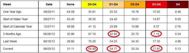
A Slow Motion Weather Disaster. No such thing as a
Drought Warning - local meteorologists aren't interrupting Dancing With
The Stars for drought updates, but what's happening over the central USA
is nothing short of a disaster for many farmers. According to the
U.S. Drought Monitor
nearly 69% of the USA is "abnormally dry". The area covered by moderate
drought has increased from 42% in late June to 54%; extreme drought has
expanded from 7% of the USA to nearly 18% of America as of September
25. Some relief is expected over the Southern Plains and Lower
Misssissippi River Valley, but little sustained relief is anticipated
from the Upper Midwest westward to the Rockies.
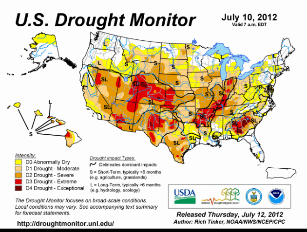
Evolution Of An Historic Drought. The time-lapse
above shows 12 weeks worth of evolving drought conditions. The soggy
remains of Hurricane Isaac provided some partial relief for the
Mississippi and Ohio River Valleys in late August and early September.
The driest conditions have been shifting westward in recent weeks; right
now the worst conditions (extreme to exceptional drought) found over
the Plains states. Map: NOAA and USDA.
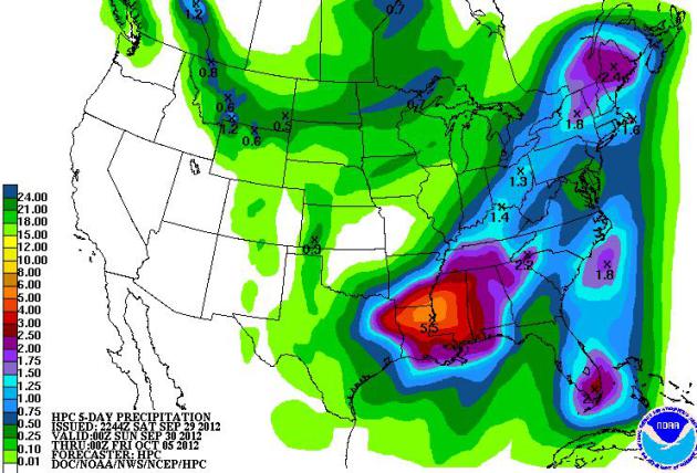
Southern Soaker. NOAA HPC's 5-Day rainfall outlook
(QPF) shows a 5-6" bullseye over the Lower Mississippi Valley, some 2-3"
amounts for south Florida, plenty of rain east of the Mississippi
River. But the west remains dry through next week.
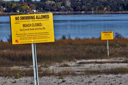
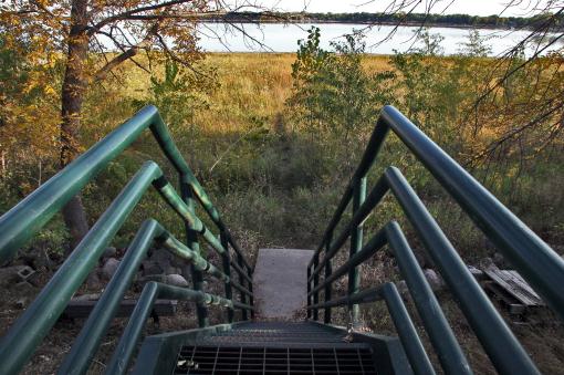
Expanding Drought - Exhibit A. There was a lake here
the last time I checked. This photo sums up the problem, which has
reached alarming levels at White Bear Lake: "
White Bear Lake is
plummeting to a record low water level due to the current drought and
large amount of groundwater pumping. Stairways that formerly led to
water's edge now end at a grassy beach." (MARLIN LEVISON/STARTRIBUNE).
Role Reversal. Last summer much of Texas was
enduring an historic drought - the worst on record. It's still dry over
much of Texas, but yesterday Abilene experienced torrential rain and
flash flooding. This
photo courtesy of @emiliacakes.
16 months in a row of warmer than average
temperatures in the Twin Cities metro. Temperatures have been
consistently warmer than average since June, 2011.
"...
The fact that outdoorsmen — 50 percent of whom identify as
conservative — are firmly aware of the changes on our natural resources
from global warming makes sense. As Theodore Roosevelt IV put it:
"The nation’s fishermen and hunters are in the frontline of our field naturalists. Doing what they love best they see firsthand the impact of climate change on natural systems and our wildlife. Their conclusions are based on observations made over years spent in the out of doors." - from a post at Think Progress below.
"...
For conservatives," he says, "it's seen as an attack on our
lifestyle. You can't live in the suburbs. You gotta give up that big
car." He knows people don't like to be told what to do. But Inglis
remembers his dad teaching him to save gas by letting up on the pedal
and coasting. He says a party that once valued thrift now touts a
philosophy of "burn it up." "It's not conservative to waste stuff,"
Inglis says, "and to cause somebody else's kids to go on the sands of
the Middle East to fight for that stuff that we're wasting." At stake,
he says, is the most basic of conservative principles: whether we leave
our children a place that's pleasant and livable." - from a post describing a conservative approach to climate science at North Country Public Radio; details and links below.
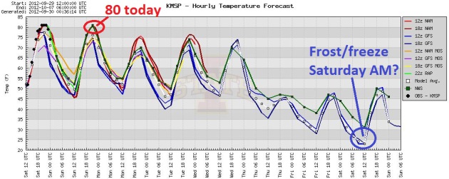
4 More Days Of Warmth - Then Reality. After flirting
with 80 again today temperatures fall (very slightly), but highs surge
into the 70s Monday thru Wednesday, before tumbling Thursday and Friday.
A few models are still hinting at a metro-wide frost or freeze by
Saturday morning. Graph: Iowa State.
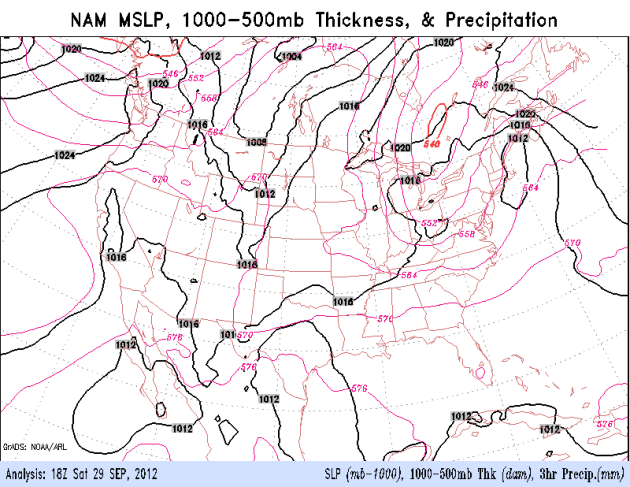
Moisture Imbalance. A slow-moving storm (the same
one that produced flooding over Texas) will push soaking rains across
the Gulf Coast and Mid South into Monday. Meanwhile a cold upper level
low pressure swirl will spark clouds and mainly late-day instability
showers over New England, while unseasonable warmth pushes across the
Northern Plains and Midwest. Cold air pushes south out of Canada the
latter half of the week.
No Significant Rain In Sight. The ECMWF (European)
model keeps us fairly dry, prevailing west/northwest winds aloft
preventing any substantial moisture from bubbling northward out of the
Gulf of Mexico. Warm weather spills over into midweek, but jackets stage
a comeback from Thursday into Monday of next week. Mercifully the
predicted highs above (in red) are in Celsius. No worries...
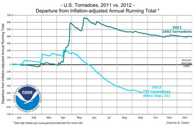
USA Could See Record Quiet Year For Tornadoes.
One silver lining to record heat and drought? No clouds, no wind shear,
no boundaries to spin up tornadic "supercells". Here's a clip from a
story at USA Today and
firstcoastnews.com: "
Following
on the heels of a deadly 2011, when almost 1,700 tornadoes killed 553
Americans, 2012 has been a remarkably quiet year for tornadoes across
the USA. "We may set an all-time record low for the year," says
meteorologist Harold Brooks of the National Severe Storms Laboratory in
Norman, Okla. So far this year, about 750 tornadoes have been reported
in the USA. At this time last year, about 1,500 had formed. An average
year, to date, has about 1,200 tornadoes, says Greg Carbin, warning
coordination meteorologist at the Storm Prediction Center in Norman."
Graphic: Greg Carbin, NOAA Storm Prediction Center.
Hurricane Isaac Damaged 59,000 Homes In Louisiana, Officials Estimate.
Keep in mind Isaac was a Category 1 storm, but it stalled, prolonging
storm surge waves and torrential rains. Here's an excerpt from The
Times-Picayne at
nola.com: "
Hurricane Isaac
damaged nearly 59,000 homes as the slow-moving storm crawled across
southeast Louisiana, according to the latest damage estimates released
Friday. The Governor's Office of Homeland Security and Emergency
Preparedness said the most severe damage hit houses and rental units in St. John the Baptist and Plaquemines parishes,
where flooding swamped some homes with several feet of water. The
latest estimates -- 46,663 owner-occupied houses and 12,289 rental units
damaged by the storm -- were more than four times the preliminary
figures released a week after Isaac made landfall Aug. 28."
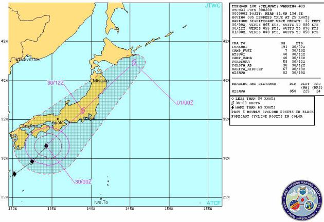
Typhoon Jelawat Soaks Japan. Typhoon (same thing as a
hurricane) Jelawat is forecast to weaken to tropical storm status
today, but winds near Tokyo may still gust as high as 50-70 mph with
torrential rains capable of significant flooding. Forecast map courtesy
of the
U.S. Navy.
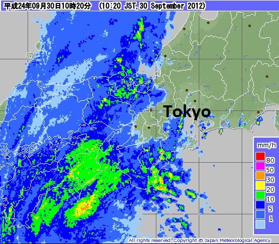
Soaking Rains For Tokyo. Last night's radar image from JMA, the
Japan Meteorological Agency,
showed heavy rains from a rapidly weakening Typhoon Jelawat approaching
Tokyo, where winds may top 50-60 mph today. Expect flight delays and
cancellations with severe flooding across much of Japan.
Putting The Eyes Of The Crowd Into The Eye Of Hurricanes. Crowd-sourcing hurricane wind information? Why not. Here's an excerpt of another fascinating article from
Climate Central: "
Ordinarily,
it takes an advanced degree and years of training to become a bona
fide hurricane expert. But thanks to an innovative new project,
ordinary citizens can make a real contribution to hurricane science
armed with little more than an internet connection, a sharp eye and a
bit of enthusiasm. The project is known as Cyclone Center,
and it’s designed to crowdsource one of the most important questions
facing scientists: how strong are the winds in the average hurricane or
typhoon?"
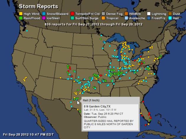
Storm Reports. September and October can bring a
secondary spike of severe weather, as chilly Canadian air advances
south. A persistent frontal boundary produced hail, straight-line winds,
even a few tornadoes from Colorado and Texas into the Ohio Valley. The
map above shows a week's worth of severe storm reports; hail in blue,
flash flooding in green, tornado reports show up as red dots. That's one
small consolation of a drought: no Gulf moisture capable of sustaining
severe T-storms. Map: NOAA SPC and
Ham Weather.
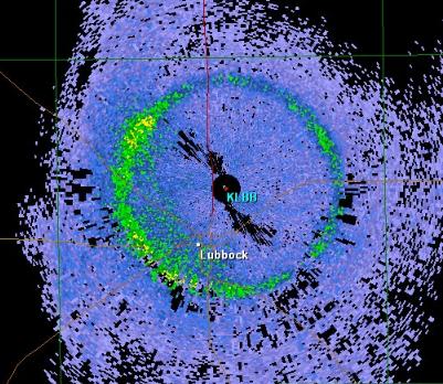
Ring Around The Doppler. What could produce such an
artifact? If you guessed "melting snow" you would be correct. You win
nothing, except the satisfaction of realizing that you're an
above-average weather geek (um...enthusiast). Details from the
Lubbock, Texas National Weather Service: "
A
curious RADAR display this morning - perhaps you can guess what caused
it. We call it a "bright band" and it typically shows up during cool
season stratiform rain. A hint: the altitude of the band varies
depending on how warm or cool the airmass is that the rain falls
through. This mornings bright band is around 8500 to 9000 feet above the
ground over the Texas South Plains - typical of an early fall tropical
airmass. We are looking at an approximate 9.9 degree elevation cut, as
opposed to the familiar 0.5 degree slice we normally look at. Could it
be either birds/insects flying off? How about an earthquake? Well, if
you guessed instead melting snow - then you are correct. As snowflakes
melt they add a layer of water onto the snow flakes and become highly
reflective within the melting layer (also very close to the freezing
level), thus causing a concentric ring around the RADAR dome location."
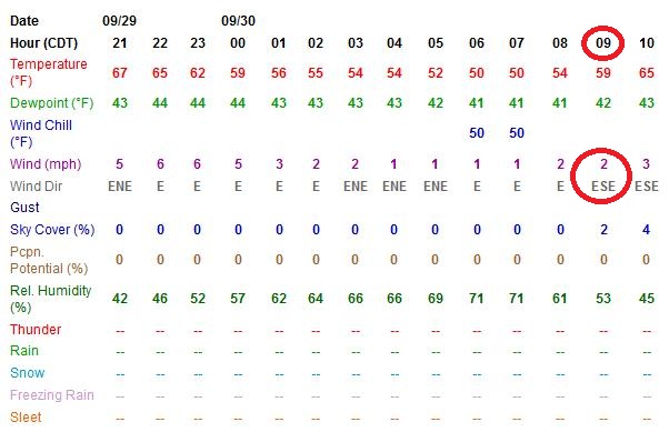
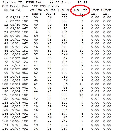
"Ask Paul". Weather-related Q&A:
Paul,
I've been trying to go up in a hot air balloon and it's always too
windy and called off. What's the wind forecast for Sunday the 30th
around 9 am? Thanks.
David Nelson
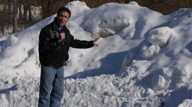
* file photo above taken in early March, 2011. That was the winter MSP picked up 86" of snow.
David - I may not have caught you in time for a Sunday balloon ride
(sounds like an inspired idea!) Here are two links that may be able to
help with future wind forecast needs. The
hour by hour forecast
for MSP (above) is from the local NWS office in Chanhassen and goes out
48 hours into the future (be sure to refresh your browser to get the
latest, greatest data). The
GFS outlook (below) goes out 180 hours, with 10 meter wind forecasts every 6 hours.
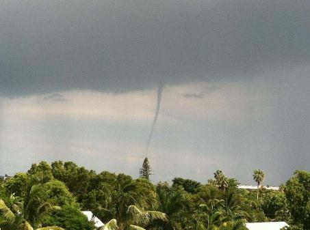
Waterspout! The National Weather Service in Key West has details, via
Facebook: "
Waterspout report just in. Waterspout located at 120 yards South of Smathers Beach."
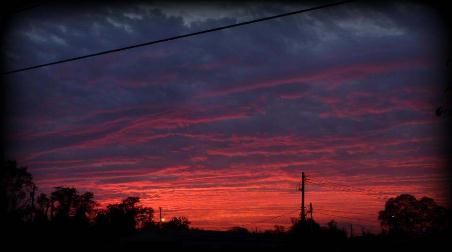
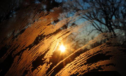
Autumnal Sunset. Thanks to Matt Crilley, who snapped
this photo of the setting sun illuminating a mid-level altocumulus
cloud deck over Waynesboro, Pennsylvania. Photo courtesy of
WeatherNation TV.
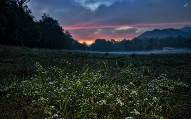
Great Smoky Mountain Sunrise. I'm impressed with the
quality of photography we're receiving on a consistent basis. This pic
is courtesy of Chris Higgins Photography and
WeatherNation TV: "
Sunrise from Cades Cove in The Great Smoky Mountain National Park this morning, before the rain moved in."
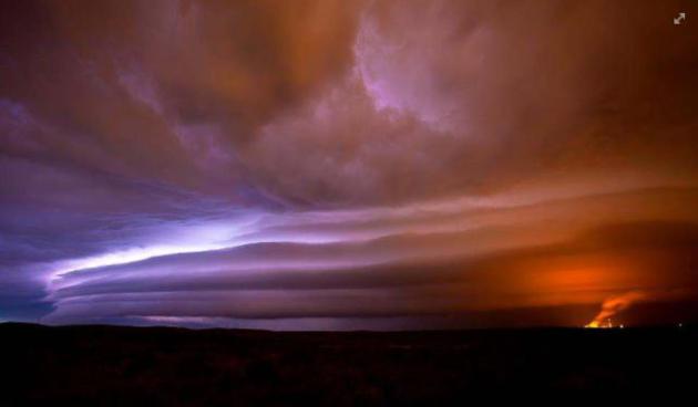
"Sunflower Shelf Cloud". This (stunning) photo of an advancing severe thunderstorm, lit up from below by cloud to ground lightning, was taken by
Scott Ackerman Photography,
courtesy of WeatherNation TV. The smooth, laminar cloud formation was
triggered by a temperature inversion, temperatures warming with
altitude. Amazing.
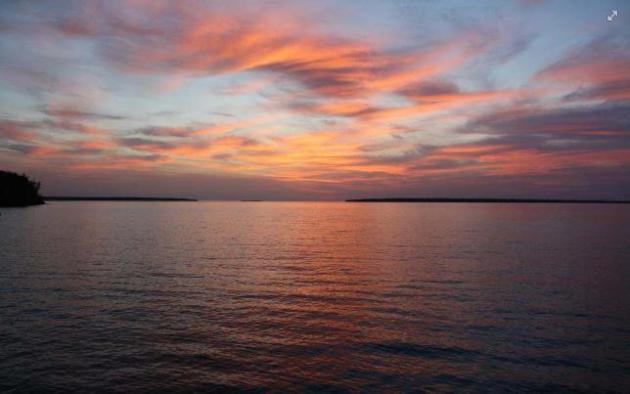
A Sunrise To Remember. Here's a
panorama of The Apostle Islands and Lake Superior, taken by Migizi Gichigumi on Friday.
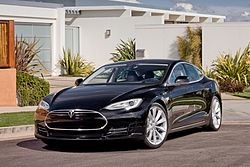
One Big Step For Tesla, One Giant Leap For E.V.'s.
I'm a car nut, and I have to admit that I love this car. It's the Tesla
Model S, made in America, all electric, all the time. Will
electric-powered vehicles catch on over time? Here's an excerpt of a
fairly glowing review from
The New York Times: "
AUTOMAKERS
have a favored buzzword for promoting important new models:
game-changer. Excuse me, but the game is not so easily changed. Put
simply, the automobile has not undergone a fundamental change in design
or use since Henry Ford rolled out the Model T more than a century
ago. At least that’s what I thought until I spent a week with the Tesla
Model S. The 2012 Model S, a versatile sedan that succeeds the
company’s two-seat Roadster, is simultaneously stylish, efficient,
roomy, crazy fast, high-tech and all electric. It defies the notion
that electric cars are range-limited conveyances."
Photo credit:
Wikipedia (which has more details on this EV).
Twitter is 'gonna be HUGE!
Words of Wisdom. Thanks to
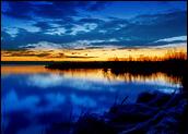
someecards.com and my sister, Joan, who is German, so she can almost get away with sharing this. "Ich liebe dich!" How romantic.
* photo above from Peg Linge, who snapped this blog-worthy photo of a
memorable sunrise from her yard in Prescott, Wisconsin Saturday
morning.
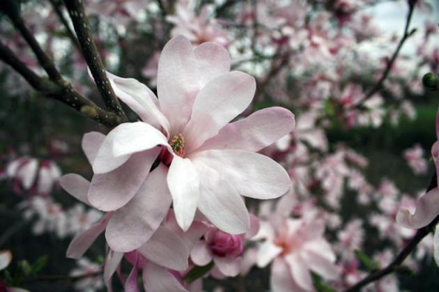
Time Machine
A 6 month boating season...in Minnesota? It's
been quite a year. Thursday evening I participated in a town hall
presentation on climate change at Champlin Park High School. University
of St. Thomas climate scientist John Abraham spoke, along with Lee
Frelich, Director of the University of Minnesota's Center for Forest
Ecology.
I'm not easily shocked anymore, but Dr. Frelich
showed a slide that left me a little wobbly: a photo of magnolia trees
in full bloom on the St. Paul Campus. On March 27, 2012. "Early spring
of 2012 was similar to projected temperatures for a "business as usual"
climate change scenario for the year 2090" he explained to a rapt
audience of concerned citizens.
Alarmist? Warmist?
Yep.
Bottom line: the changes we're seeing are
happening much faster than those (alarmist!) climate scientists
predicted 20-30 years ago.
I'm confident we'll figure out solutions, but getting past denial is step 1.
Welcome to The Big Slide: near 80 again today
under a flawless sky; a metro-wide freeze possible by next Saturday
morning. Heavy rain spreads over Iowa and Wisconsin, but not here.
Farmers are worried. So are residents of White Bear Lake. Evaporation
and wells are taking a toll.
We need rain, but I don't see any rapid reversals to our dry pattern looking out into mid-October.
Stay tuned.
* photo above courtesy of Jenna Williams and Dr.
Lee Frelich, Director of the University of Minnesota's Center for
Forest Ecology.
Climate Stories...
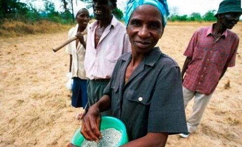
Climate Change Is Already Damaging World's Economy. The story from The Guardian and
Climate Central; here's an excerpt: "
Climate
change is already contributing to the deaths of nearly 400,000 people a
year and costing the world more than $1.2 trillion, wiping 1.6 percent
annually from global GDP, according to a new study. The impacts are
being felt most keenly in developing countries, according to the
research, where damage to agricultural production from extreme weather
linked to climate change is contributing to deaths from malnutrition,
poverty, and their associated diseases. Air pollution caused by the use
of fossil fuels is also separately contributing to the deaths of at
least 4.5 million people a year, the report found."
Photo credit above: "
Impacts
of climate change are mostly keenly felt in developing countries where
damage to agricultural production from extreme weather is contributing
to deaths from malnutrition, poverty and their associated diseases." Credit: NEWSCOM.
 When Will Candidates Address Climate Change?
 Here's an excerpt of an Op-Ed at
delawareonline.com: "...
A
study published last year by scientists at Stanford and MIT reported
that chemically removing carbon dioxide from the atmosphere would cost
about $1,000 a ton. That means it would cost $600
trillion to remove 600 billion tons, and we’re increasing our
“environmental debt” by more than $30 trillion a year! Those numbers
can be compared to the 2011 world GDP of about $70 trillion.As Hansen said: “The era of doubts, delays and denial, of ineffectual half-measures, must end...."
Photo credit above:
politico.com.
Species Loss Creates More Climate Change Sensitivity. Here's the intro to an interesting story at
Sci-Tech Today: "
Climate
change can exacerbate the negative effects of losing sensitive
species, researchers say. Biodiversity acts as an insurance policy as
it increases the likelihood at least some species will be sufficiently
resilient to sustain important functions such as water purification and
crop pollination in a changing environment. Species loss and
reduced biodiversity make nature more sensitive to climate change,
Swedish researchers say. This is especially true for species that
sustain important functions such as water purification and crop
pollination in a changing environment, they said."
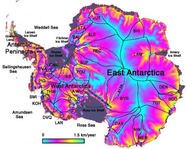
Southern Ocean Warming Impact On Antarctic Ice Sheet And Global Sea Level Rise.
Indybay.com has an interesting article about warming oceans and possible impacts on Antarctic ice; here's an excerpt: "
Climate
change is causing the southern ocean to warm and freshen which will
melt ice shelves and glacier tongues affecting glacier discharge and
producing Antarctic Ice Sheet mass loss and global sea level rise. A
new study shows that small temperature changes of the Southern Ocean
can contribute to far-reaching changes on the Antarctic ice sheet that
could lead to substantial future sea-level rise."
Politicians And Their Professors: The Discrepancy Between Climate Science And Climate Policy.
This should be required reading for every politician, local, state and
national, but why do I think that won't happen anytime soon? Here is an
overview of the (pdf) overview from
The Better Future Project at Cambridge, Mass: "
This
report seeks to highlight the discrepancy between the overwhelming
consensus on climate change that exists among the nation’s scientific
community and the lack of action by federal leaders. Past studies have
shown that 97-98% of climate scientists who publish in peer-reviewed
journals agree with the consensus that climate change is real, happening
now, and man-made. Since many politicians seem to disregard the views
of such scientific “elites” as a whole, we decided to compare
politicians’ views on climate change to those of the climate experts at
their alma maters. These politicians clearly valued the expertise of the
academics at their schools enough that they chose to (usually) spend
tens of thousands of dollars and up to four years of their lives
absorbing knowledge from these institutions’ experts. We thought that
even if these politicians choose to disregard the consensus of national
experts, they might be persuaded by the consensus of the higher
education institutions in which they trusted enough to invest great
amounts of their time and money."
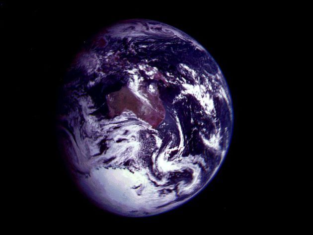
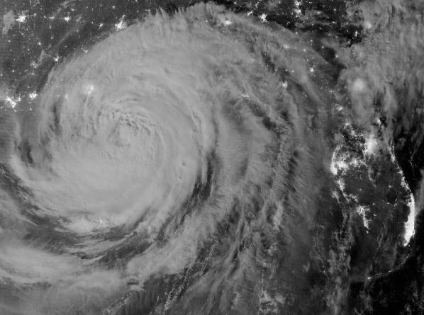
Extreme Weather: Arctic Ice At Lowest Point In A Million Years. It will be interesting to see if this statistic holds up - here's an excerpt from the
San Francisco Examiner: "...
According to Frank J. Dinan,
an emeritus professor of chemistry at Canisius College, "The GWP of
methane gas combined with the rapid warming of the Arctic will give rise
to a potentially disastrous positive feedback loop. As the Arctic's
permafrost regions warm, methane gas is released. Methane's high GWP
assures that the Earth will warm even more rapidly as the gas enters our
atmosphere. This increased warming will result in methane being
released even more rapidly, thereby establishing a snowballing feedback
cycle leading to increasingly rapid climate change." Research documents
show that 48 million tons of methane are entering our atmosphere from
eastern Siberian permafrost alone each year. That amount is sure to
grow." Photo above: NOAA.
New Guide For Scientists: Responding To Criticism And Personal Attacks. Yes, nasty out there - it seems the same climate-denial-trolls keep showing up, parroting the same talking points.
The Union of Concerned Scientists has a post on responding to these tactics; here's an excerpt: "
Scientists
find themselves under scrutiny now more than ever before, and that
scrutiny intensifies when their research is at the center of a public
policy debate. Sometimes, this scrutiny helps educate the public and
clarify what we know; at other times, this scrutiny is designed to
confuse the public and policymakers. Today, UCS is releasing a guide that
helps scientists deal with harassment and other unwarranted attacks on
their integrity and their work. Many people think of climate scientists
when they think of harassment—and they’re not wrong. Climate scientists have faced subpoenas, intrusive open records requests, threatening phone calls, even dead rats on their doorsteps."
Global Warming Is Solved: Just Make Snow Out Of Sewage. Here's a snippet from an article at
Gawker.com: "
Yes,
sure, global warming is leading us inexorably down the path to all-out
global war due to massive human displacement and destruction of
resources. But let's focus on the real problem: what about ski resorts?
What if people were forced to go skiing later in the season? Absolutely
unacceptable. Fortunately, America is ready to tackle this problem
head-on. Problem: warmer weather means less good snow for rich people to
go skiing. Solution, at the Arizona Snowbowl ski resort:
"use 100 percent sewage effluent to make artificial snow." Now all of
the rich people will be able to ski on sewage! Sewage full of
"hormones, antibiotics, antidepressants, pharmaceuticals and steroids."
But on the upside: skiing in November, in Arizona. The NYT quotes an official from the US Forest Service offering this bulletproof rationale: "Snow-making has become necessary because of climate change."
Poll: 69% of Hunters and Anglers Say We Should Reduce Carbon Emissions That Contribute To Global Warming.
I run into many fishing and hunting enthusiasts who tell me that
they've seen significant changes in Minnesota's lakes and fields. Here's
an excerpt of a post at
Think Progress: "
The National Wildlife Federation has issued a new poll outlining the priorities and opinions of America’s sportsmen (and women). Conducted by a Republican polling firm,
the poll asked hunters and anglers who vote questions about
conservation, public lands, energy, and climate change. One of the most
important findings is that 59% of sportsmen agree that “global warming
is occurring,” while 69 percent say that we should reduce carbon
emissions that are contributing to the problem. The fact that
outdoorsmen — 50 percent of whom identify as conservative — are firmly
aware of the changes on our natural resources from global warming makes
sense."
Climate Change Kills 400,000 A Year, New Report Reveals.
The Daily Beast has the story; here's an excerpt: "
Nearly 1,000 children a day are now dying because of climate change, according to a path-breaking study published Wednesday (PDF), and the annual death toll stands at 400,000 people worldwide. Climate change
also is costing the world economy $1.2 trillion a year, the equivalent
of 1.6 percent of economic output, reports the Climate Vulnerability
Monitor, a study commissioned by 20 of the world’s governments whose
nations are most threatened by climate change and released on the
sidelines of the U.N. General Assembly meeting in New York." Photo above: NASA.
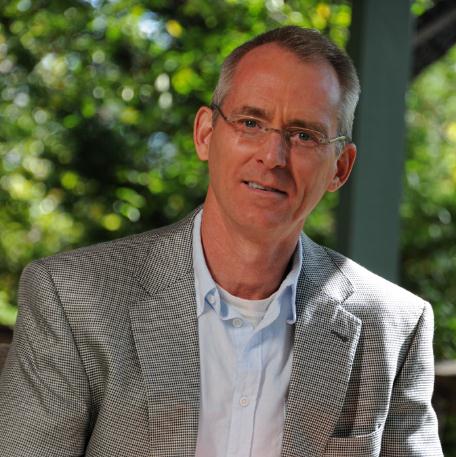
New Groups Make A Conservative Argument On Climate Change.
I think Bob Inglis, former Congressional Representative from South
Carolina, is onto something. An interview he gave to NPR's All Things
Considered resonated; here's an excerpt from
North Country Public Radio: "...
These days, Inglis heads the Energy and Enterprise Initiative
at George Mason University, making a free market case for tackling
global warming. "We think free enterprise has the answer to energy and
climate," Inglis said at a recent meeting of students with the Wharton
Energy Club at the University of Pennsylvania. "There's an incredible
opportunity in energy, if we just get the economics right." Inglis
proposes eliminating government incentives: no more tax breaks for
solar panels or electric cars; no more subsidies for oil companies.
Then, he says he would impose a carbon tax on fossil fuels. We already
pay more, he says, just in hidden ways, like detrimental health impacts
from coal-fired power plants or higher insurance costs from extreme
weather linked to greenhouse gases. This "market distortion," he says,
leaves fossil fuel companies unaccountable."
Photo credit above: "
Former South Carolina Republican Rep. Bob Inglis now runs the Energy and Enterprise Initiative." (Energy and Enterprise Initiative)
Young Conservatives for Energy Reform. I almost fell off my chair when I clicked on
this site.
It would appear there are a growing number of conservatives who see
climate change as a threat, and an opportunity to reinvent America.
Environmentalists Get Vocal On Obama, Romney Silence On Climate Change.
The Hill has the story; here's a clip: "
A
handful of environmental groups are amplifying calls Thursday for
President Obama and GOP presidential candidate Mitt Romney to speak up
on climate change after a summer of devastating drought, fires, storms
and heat. Friends of the Earth and Forecast the Facts debuted a website
Thursday called ClimateSilence.org that asks visitors to sign a
petition asking Obama and Romney how they would address climate change
if elected. The website, which features photos of Obama and Romney with
their mouths duct taped, tracks the candidates’ climate change mentions
on a timeline."


