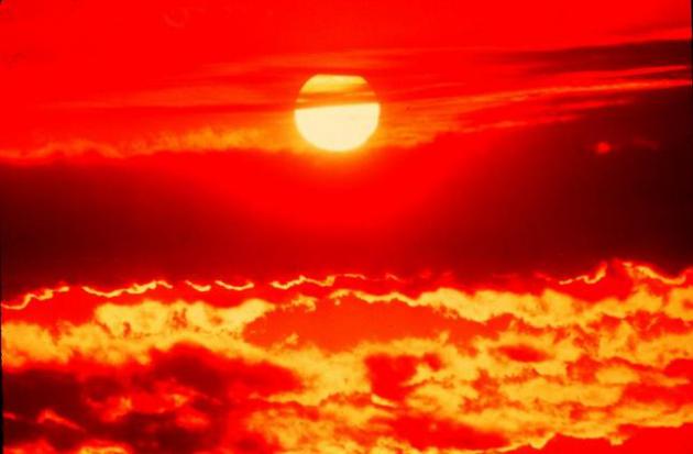
Arizona Dry Thunderstorms (Monsoon Season)
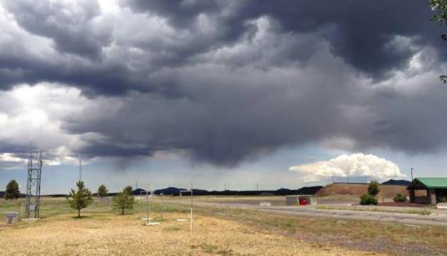
Dry Thunderstorms? How could that be?? The image below from the
National Weather Service out of Flagstaff Arizona shows a "Dry
Thunderstorm" perfectly! Look how the rain evaporates before it reaches
the ground! Because it is so hot and dry, those rain showers tend to dry
up before it hits the ground.
"The
intense heat which has invaded Northern Arizona has resulted in a very
unstable atmosphere across the high country. Hot temperatures near the
ground are combining with some mid level moisture to produce high
based thunderstorm activity. This type of pattern often results in
mostly dry thunderstorms (Producing little, or very light rainfall) but
gusty winds and lightning. Not a good situation considering the
extreme fire danger!"
See more HERE:
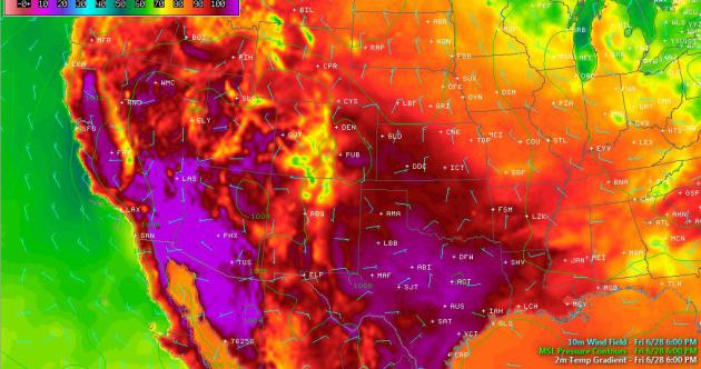
Southwest Heat
YIKES! Look at how hot the temperature map looks below! The deep red
and purple colors indicated temps around 100F or higher!. Some spots may
even be near record territory for several days! This weekend will
likely be the hottest time period during this heat wave!
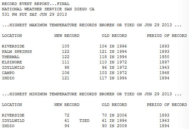
Record Heat Continues
National Weather Service Offices in the Southwest have put great
lists together with expected high temps vs. records through early next
week. Take a look below at some of the hot spots near Las Vegas and
Death Valley, CA. Note that some of the locations below could be near
All-Time record highs!
See more NWS Weather Stories HERE:
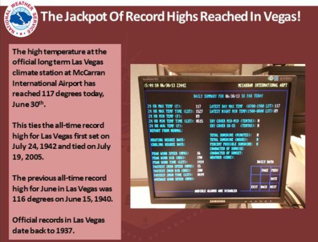
Las Vegas, NV
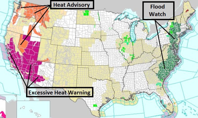
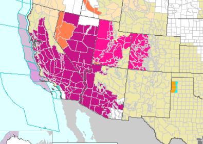
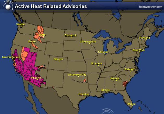
Excessive Heat Headlines
Take a look at how many areas in the West will be under excessive
heat headlines this weekend. Deep red/purple colors indicate
EXCESSIVE HEAT WARNINGS. Temps in some spots will be 110F to 120F or
more through early next week.
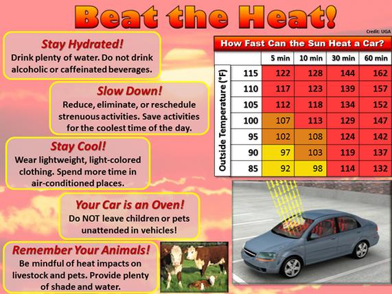
Respect the Heat!
Heat is one of the leading weather-related killer in the United
States, resulting in hundreds of fatalities each year. In the
disastrous heat wave of 1980, more than 1,250 people died. In the heat wave of 1995
more than 700 deaths in the Chicago area were attributed to heat,
making this the deadliest weather event in Chicago history. In August
2003, a record heat wave in Europe claimed an estimated 50,000 lives.
North American summers are hot; most summers see heat waves in
one or more parts of the United States. East of the Rockies, they tend
to combine both high temperatures and high humidity, although some of
the worst heat waves have been catastrophically dry.
Read more Heat Safety Tips HERE:
Heat-Related Illness Symptoms and First Aid
HEAT CRAMPS
- Symptoms:
- Painful muscle cramps and spasms usually in legs and abdomen
- Heavy sweating
- First Aid:
- Apply firm pressure on cramping muscles or gentle massage to relieve spasm.
- Give sips of water, if nausea occurs, discontinue water
HEAT EXHAUSTION
- Symptoms:
- Heavy sweating
- Weakness
- Cool, pale, clammy skin
- Weak pulse
- Possible muscle cramps
- Dizziness
- Nausea and vomiting
- Fainting
- Normal temperature possible
- First Aid:
- Move person to a cooler environment
- Remove or loosen clothing
- Apply cool, wet cloths
- Fan or move victim to air conditioned room
- Offer sips of water. If nausea occurs, discontinue water. If vomiting continues, seek immediate medical attention.
HEAT STROKE (or sunstroke)
- Symptoms:
- Altered mental state
- Possible throbbing headache, confusion, nausea, dizziness, shallow breathing
- High body temperature (106°F or higher)
- Skin may be hot and dry, or patient may be sweating
- Rapid pulse
- Possible unconsciousness
- First Aid:
- Heat stroke is a severe medical emergency. Summon
emergency medical assistance or get the victim to a hospital
immediately. Delay can be fatal.
- Move the victim to a cooler, preferably air-conditioned, environment
- Reduce body temperature with a water mister and fan or sponging
- Use fan if heat index temperatures are below the high 90s
- Use extreme caution
- If temperature rises again, repeat process
- Do NOT give fluids
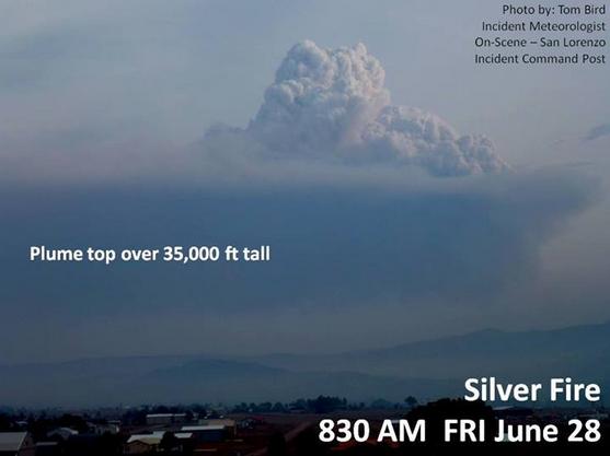
Southwest Fires
Hot and very dry weather is having an impact on fire weather this
year. One expert described fire fuels this year are nearly 2 months
ahead of schedule! The Silver Fire continues to burn in New Mexico. The
fire is so large, that the smoke plume can be seen from Texas!
"Quick
Photo-Update from the Silver. 8:30 am 6/28...the fire is developing
another HUGE plume that is punching upwards of 35,000ft. It has the
heat to blow way past the stable layer, exhibited by the of spread out
flatter smoke layer. This is a VERY dangerous situation. Firefighters
are keeping a respectful distance at this time. Structure protection
is ongoing to the northwest of the fire. The fire is growing toward
the NW."
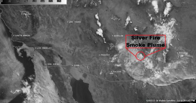
Silver Fire from Space
This is what the Silver Fire looks like from space. It's hard to pick
out the plume between all the other clouds, but it's there! The latest
from www.inciweb.org suggests that the Silver Fire is 92,000+ acres in
size and is only 20% contained.
See more from Inciweb.org HERE:
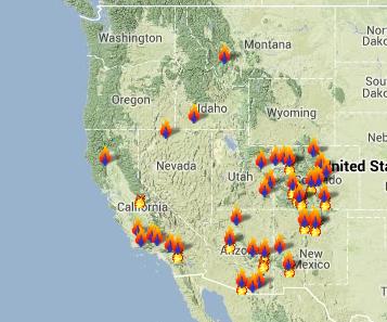
Western Wildfires
Look at how many wildfires there are in the western part of the
country. According to www.inciweb.org, another large fire is ongoing in
southcentral Colorado; the West Fork Complex is 90,000+ acres in size
and is 0% contained
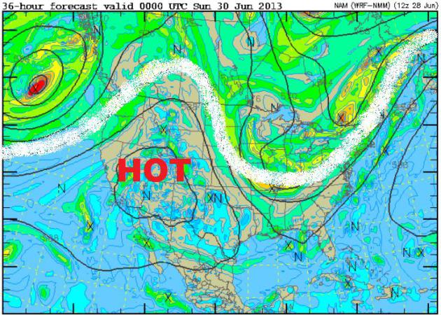
Why So Hot?
Look at how far north the strong upper level winds have bubbled up
into Canada! This indicates a ridge of high pressure where dry, sinking
air is occurring. Keep in mind that as air decends, it tends to dry out
and warm up, so the heating process is working even better now!
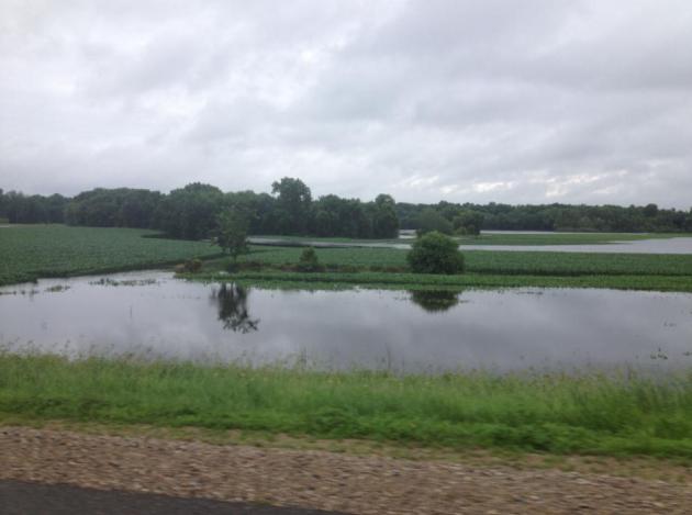
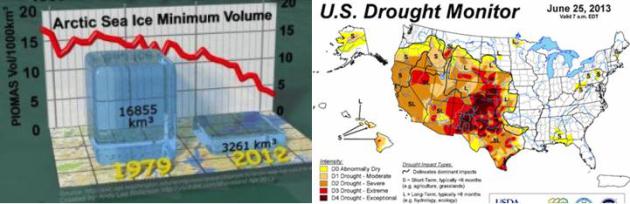
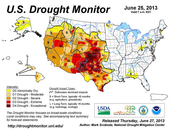
Western Drought, Eastern Deluge
The rich get richer and the poor
get poorer - unfortunately for folks in the West, hot and dry
conditions have been an ongoing theme now for several weeks and it
doesn't seem like we're going to see that change anytime soon.
Meanwhile, folks in the East continue to get copious amounts of
moisture, which is good because we're seeing the drought disappear, but
in some cases we've had so much rain that flooding is now an issue!
The West: Changes aplenty this week as spring
gives way to summer and summer heat is making its presence felt with
fires (or the threat of) continuing to steal the impacts spotlight for
many. New Mexico continues to forge into uncharted territory, with
data from NOAA-National Climatic Data Center (records going back to
1895) showing the past 12 months to be the driest on record for the
state coupled with the past 24 and 36 months coming in as the second
driest on record. Virtually the entire state falls within the two
worst categories on our drought severity scale, D3 and D4. All eyes
will be squarely affixed on the upcoming monsoon season.
Wyoming sees improvements in the northeastern corner of the
state and degradation in the south, with the trimming of D0/D1 in the
northeast and expansion of D2/D3 in the south in proximity to the
Colorado and Nebraska borders.
Colorado’s situation continues to deteriorate under the
influence of summer’s heat, noted by expansion of D2 in the
northeastern corner of the state as well as a slight push north and
west of D3 in the southeastern corner. Fire still remains front and
center with regard to impacts, but rangeland conditions continue to take
a beating all along the Front Range.
Arizona and Nevada both see increases in drought conditions this
week. In Nevada, D2 pushes farther east toward the Utah border while
in Arizona both D2 and D3 expand slightly in the north central region
and within the Navajo Nation.
For a second consecutive week, California sees a push of D2
across all of the Sacramento Valley and points eastward into more of
both the Cascades and the Sierra Nevada. Recent rains in and along the
northwestern coastal ranges have not been nearly enough to offset the
record to near-record year-to-date deficits that have led to reduced
streamflows in many basins.
Midwest: The transformation to normal continues
in the upper Midwest with heavy rains (2-5+ inches) bringing
substantial improvements to Minnesota and northwestern Iowa. D1 has
been removed from southwest Minnesota and D0 has been reduced as a
result, leaving the only drought in the state confined to the Red Lake
region in the northwest. Abnormally dry (D0) conditions were also
reduced in northwestern Iowa on the heels of recent improvements.
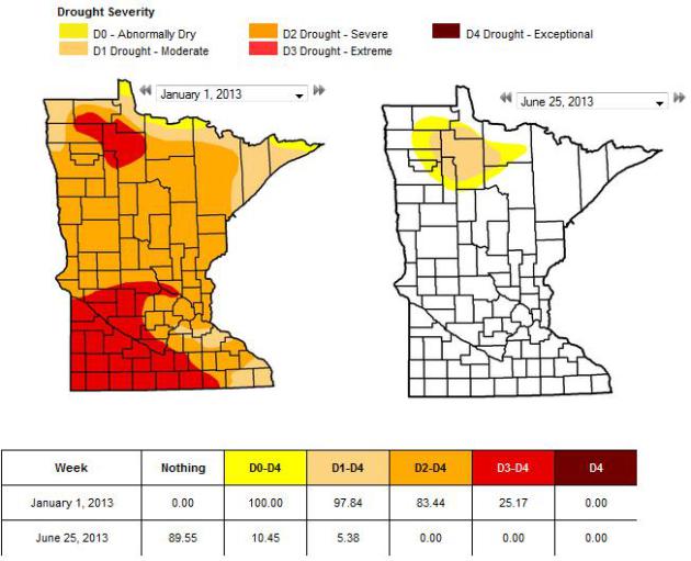
Minnesota Drought
Wow! What a difference 6 months makes! Minnesota has seen one of the
most dramatic changes since the beginning of the year. All but 5%
moderate drought has been wiped out since the beginning of the year,
when 98% of the state was in a moderate drought, 83% was in a severe
drought and 25% was in an extreme drought! Talk about weather
whiplash... last year we were talking about extremely dry conditions and
now we're talking about flooding!
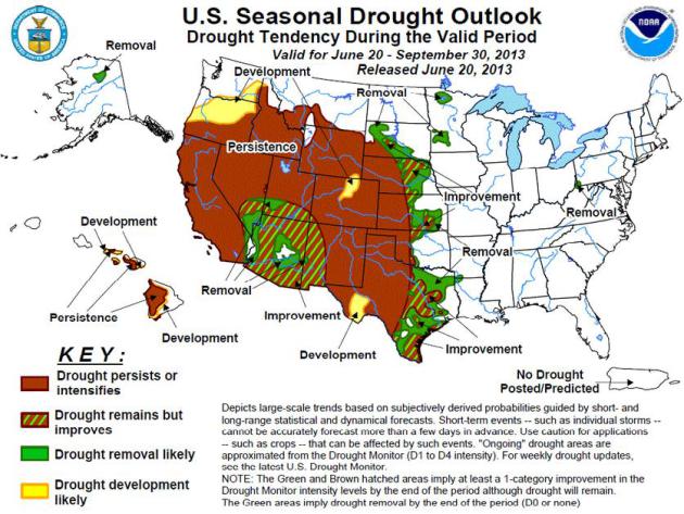
U.S. Drought Outlook
Drought continues in the West, but a start to monsoon season may help to east drought conditions a bit in the Southwest!
Latest Seasonal Assessment -
During the previous thirty days, wet weather and cooler temperatures
overspread the far north central United States and the central corn
belt, easing drought conditions but also causing planting delays and
flooding along the Mississippi River basin. In contrast, dry, hot
weather exacerbated drought conditions in the southwestern quadrant
of the Nation, promoting the development of numerous wildfires across
the Four Corners states and California. In the East, a series of
storm systems including Tropical Storm Andrea brought significant
rainfall to the entire Atlantic seaboard, removing all remaining
drought areas, though abnormal dryness was observed along the Ohio
River Valley and central Appalachians. During the upcoming three
months, enhanced odds of below average precipitation are expected to
promote further drought expansion into the northwestern U.S., while
drought persistence is likely across California and the northern
intermountain West due to a dry summer climatology. In the
Southwest, the potential for a robust and early onset of monsoon
wetness may bring drought relief to Arizona, western New Mexico, and
as far north as southern Utah and Nevada. In contrast,
enhanced seasonal probabilities of abnormal dryness and warmth in
western Texas are expected to promote drought persistence and
expansion. A wet summer climatology may aid in further east to west
erosion of drought across the Great Plains, but the prospects for
relief are less certain along the High Plains, where extreme to
exceptional drought has been entrenched for months and soil moisture
is very low. Suppressed dry season rainfall in Hawaii is expected to
favor drought persistence and possible expansion, while
climatological summer precipitation in north central Alaska may improve
existing drought conditions.
See more HERE:
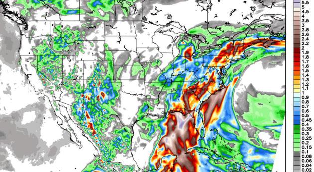
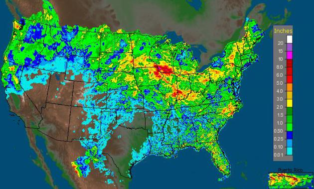
Precipitation Past 7 Days
Radar estimated rainfall over the past week suggests several inches
of rain in many areas east of the Rockies, especially in the Midwest and
also in pockets in the Pacific Northwest. All this rain coming in a
such a short amount of time has led to many areas of flash flooding this
past week.
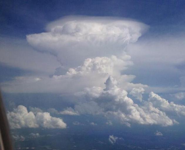
Approaching Atlanta
Thanks to Jacob Wycoff for the picture below who took this picture
from a jetliner on an approach into Atlanta. He said that they had to
circle the storm until it blew past the airport! Cool picture!
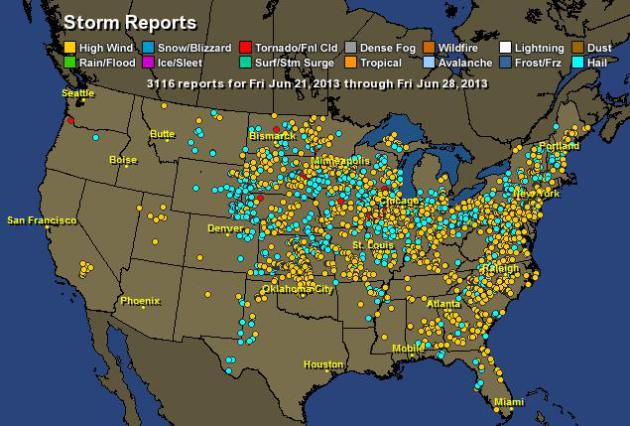
National Storm Reports
According to Hamweather.com, there have been more than 3,000 hail,
high wind and/or tornado reports over the past 7 days. Interestingly,
within that time frame, there were only 43 tornado reports and nearly
2,100 wind reports! That's pretty typical at this time of year.
Generally, the number of tornadoes goes down and the number of wind
damage reports goes up and large chunks of hot and humid air set up in
the central part of the country. "Ridge Riders" or damage wind producing
storm tend to develop on the outer periphery of this dome of hot air.
This type of weather set up can persist for days and it's exactly what
we've seen over the last several days!
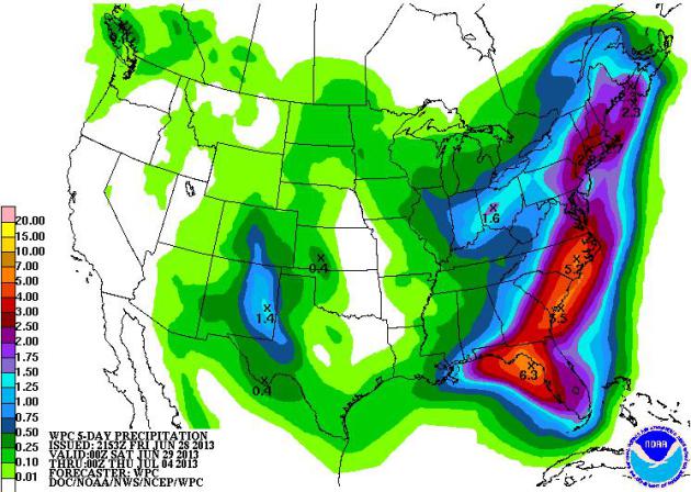
5 Day Precipitation Outlook
NOAA's HPC 5 day precipitation outlook continues to show a fairly
soggy scenario for folks east of the Mississippi River and especially
along the Eastern Seaboard. Some spots along the Carolina Coast and
Florida could see 3" to 5"+ through midweek next week!
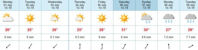
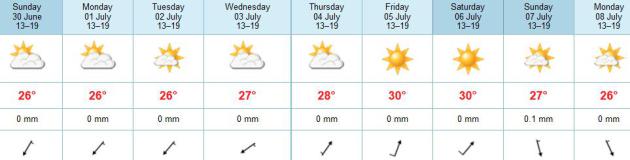
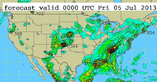
4th of July Outlook
It appears that a fairly slow weather regime will continue through
the early part of July with a large ridge of high pressure in the west
and a trough of low pressure along and east of the Rockies. What this
means is that it looks to stay mainly hot/warm and dry (with monsoonal
thunderstorms in the Southwest), while along and east of the Rockies,
we'll see pockets of showers and thunderstorms with areas of heavy
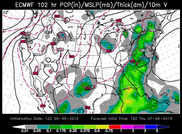
rainfall possible. The image below suggests the accumulated rainfall
potential on the 4th of July.
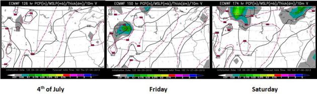
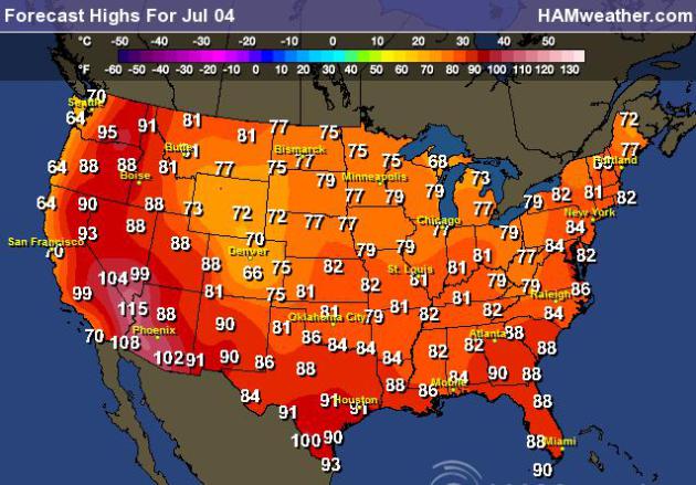
4th of July Temperature Outlook
The temperature outlook for the 4th of July looks fairly similar to
what we'll see from the weekend into much of next week. Warm/Hot in the
west and cooler along and east of the Rockies.
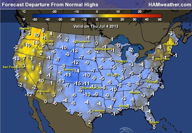
Highs From Normal on the 4th of July
If the forecast verifies, many of us will be quite a bit cooler than average on Independence Day!
Thanks for checking in, have a great weekend ahead!
Don't forget to follow me on Twitter @TNelsonWNTV