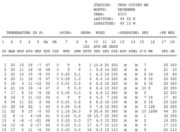
Monday, November 28, 2011

November 29: Warm Rain East (heavy snow Indianapolis to Memphis)


24.2" snow fell on the Twin Cities during the first 15 days of December last year. 16.3" of that was on one day (11th).

0: expected rain/snow over the next 84 hours (NAM model).

72 F. at Newark, New Jersey Monday; this ties the record high for November 28.


3rd busiest hurricane season on record for the Atlantic basin. Details from NOAA below.

19 named tropical storms, 7 hurricanes, 3 of which became major "Category 3" storms.

"Irene was the lone hurricane to hit the United States in 2011, and the first one to do so since Ike struck southeast Texas in 2008. Irene was also the most significant tropical cyclone to strike the Northeast since Hurricane Bob in 1991." - NOAA

Snow In Unlikely Places. The latest NAM model predicts 4-8" snow near Memphis - Indianapolis could pick up a half foot of slushy snow, with 8" for South Bend, even a few inches for the suburbs of Detroit. Map courtesy of WeatherCaster.


Winter Storm Warnings....For Alabama? Yes, while we see bright sun and temperatures a few degrees above average, folks down south will be shoveling, and plowing, and probably shaking their fists at Old Man Winter. Flood watches are posted from Lower Michigan southward to Kentucky for some 1-3" rainfall amounts. For the latest (interactive) watches and warnings from NOAA click here.

  Rainfall Amounts, courtesy of NOAA HPC:

..ALABAMA...
MENTONE 3.9 SW                        5.22
SYLVANIA 3.4 ESE                      4.81
ROSA 2.8 SW                           4.07
PRINCETON 3.6 NW                      3.93
BIRMINGHAM MUNI ARPT                  2.95
ANNISTON METRO AIRPORT                2.84
MONTGOMERY/DANNELLY                   2.84
ALABASTER/SHELBY CO. ARPT             2.71
MAXWELL AFB/MONTGOMERY                2.70
ALEXANDER CITY                        2.51
HUNTSVILLE/MADISON CO. ARPT           2.22
MOBILE DOWNTOWN AIRPORT               1.74                     

...FLORIDA...
TYNDALL AFB/PANAMA CITY               2.67
VALPARAISO/EGLIN AFB                  1.80                     

...GEORGIA...
LA FAYETTE 2.9 NE                     4.00
TRENTON 5.8 S                         3.95
DILLARD 3.5 NE                        3.74
LYERLY 4.8 SSE                        3.62
SUMMERVILLE 2.6 NW                    3.51
RABUN GAP 2.1 SW                      2.94
ROME 3.4 SE                           2.70
CARTERSVILLE AIRPORT                  1.26                     

...KENTUCKY...
ALBANY 5.3 W                          3.10
WINDSOR 1.2 NW                        2.55
LEXINGTON/BLUE GRASS FIELD            2.23
LIBERTY 1.1 SE                        2.13
LONDON-CORBIN ARPT                    2.10
FRANKFORT/CAPITAL CITY ARPT           1.93
BOWLING GREEN-WARREN CO. ARPT         1.57
FORT KNOX AAF                         1.34
OWENSBORO/DAVIESS CO. APT             1.22   
                  
 ...NORTH CAROLINA...
FRANKLIN 7.5 SW                       3.64
ROSMAN 5.3 W                          3.56
ASHEVILLE MUNI ARPT                   1.18    
                 
 ...OHIO...
CINCINNATI (ASOS)                     1.54
HAMILTON ARPT                         1.43
DAYTON GENERAL AIRPORT                1.19                     

...TENNESSEE...
WHITWELL 4.5 ENE                      5.07
DUNLAP 0.4 SSE                        4.83
CHATTANOOGA-LOVELL FIELD (ASOS)       4.64
RED BANK 3.4 NNE                      4.59
JASPER 1.7 N                          4.40
OAK RIDGE (ASOS)                      3.72
CROSSVILLE MEMORIAL ARPT              3.64
SMYRNA AIRPORT                        1.66
NASHVILLE METRO ARPT                  1.54
KNOXVILLE MUNI ARPT                   1.53       


Jackson, Tennessee. Thanks to @randomgrl on Twitter for passing this along.

Monday Rainfall. NOAA Doppler radar estimates showed some 3-5" rainfall amounts over Alabama and Tennessee yesterday.

Improving Drought Conditions For Minnesota? NOAA's Drought Monitor is predicting an easing of drought conditions for southern Minnesota in the months to come, but personally, I'm not convinced. This forecast is based on an active La Nina pattern and a forecast calling for wetter than average conditions for the northern tier states. While New England and parts of the Great Lakes will almost certainly experience a snowier/wetter than average winter, I'm still concerned that prevailing jet stream winds will whisk the wettest storms south/east of Minnesota for much of the winter season. We'll see, but I still believe the drought may get worse before improving sometime in 2012. Hope I'm wrong.

Active 2011 Hurricane Season Breaks "Hurricane Amnesia". Here's a recap of a very busy hurricane year from NOAA: "The 2011 Atlantic hurricane season officially ends Wednesday, having produced a total of 19 tropical storms of which seven became hurricanes, including three major hurricanes. This level of activity matched NOAA’s predictions and continues the trend of active hurricane seasons that began in 1995. The 19 tropical storms represent the third-highest total (tied with 1887, 1995, and 2010) since records began in 1851 and is well above the average of 11. However, the number of hurricanes and major hurricanes is only slightly above the average of six and two, respectively. This year’s totals include a post-storm upgrade of Tropical Storm Nate to hurricane status, and the addition of a short-lived, unnamed tropical storm that formed in early September between Bermuda and Nova Scotia. This unnamed storm, along with several other weak, short-lived named storms, could have gone undetected without modern satellite technology. Irene was the lone hurricane to hit the United States in 2011, and the first one to do so since Ike struck southeast Texas in 2008. Irene was also the most significant tropical cyclone to strike the Northeast since Hurricane Bob in 1991. “Irene broke the ‘hurricane amnesia’ that can develop when so much time lapses between landfalling storms,” said Jack Hayes, Ph.D., director of NOAA’s National Weather Service. “This season is a reminder that storms can hit any part of our coast and that all regions need to be prepared each and every season.”

The 2011 Atlantic Hurricane Season In 4.5 Minutes. The world's longest satellite loop? The press release from NOAA: "The 2011 Atlantic hurricane season officially ends on Nov. 30 and produced a total of 19 tropical storms of which seven became hurricanes, including three major hurricanes. This level of activity matched NOAA’s predictions and continues the trend of active hurricane seasons that began in 1995. From Arlene to Sean, Hurricane Season 2011 has been very active, leading to 120 fatalities and causing more than $11 billion in property and infrastructure damage. Surprisingly, none of the first eight tropical storms reached hurricane status, a record since reliable reports started in 1851. Hurricane Irene's effects in the Caribbean and the United States lead to 55 deaths and accounted for the bulk of this season's damage, more than $10 billion. Irene was the first landfalling hurricane in New Jersey in 108 years. Hurricane Katia had far-reaching effects causing severe weather in Northern Ireland and Scotland and power blackouts as far east as Saint Petersburg in Russia. Tropical Storm Lee caused major flooding in Pennsylvania, New York and into the Canadian provinces of Quebec and Ontario. The strongest storm of the season was Ophelia, which reached category four strength in the Atlantic Ocean east of Bermuda."


2011 Hurricane Season Was Windy And Wild, But Not In South Florida. The Palm Beach Post has the story: "In the hurricane season that ends Wednesday, storms mostly have been a non issue for South Florida. The season brought a couple of scares, including Irene - which threatened a direct hit on New York City and then made a rare assault on the Northeast, causing as much as $3 billion in damage. But for the sixth straight year, no hurricane made landfall in Florida. Not even a tropical storm in 2011. So, if asked whether this was a busy year, most would again say no. They'd be wrong. It was a doozy. The 2011 season generated 19 tropical storms, of which seven became hurricanes and three became major hurricanes, at Category 3 or higher on the Saffir-Simpson scale. That ties with 2010, 1995 and 1887 for third-busiest on record. (image above courtesy of NHC and NOAA).


Weather Disaster + Business Travel: Dangerous, Disruptive and Costly. From the Sacramento Bee: "On the heels of Hurricane Irene and a freakishly early fall snowstorm, and with the impending onslaught of severe winter storms, the Global Business Travel Association has quantified the impact of major weather events on business travel. The research uses GBTA's Business Travel quarterly (BTQ) methodology to determine how a theoretical Category-3 hurricane on the East Coast would impact the business travel industry. The results can be applied to any significant weather event that leads to widespread shutdowns and canceled travel plans, such as East Coast snowstorms."

Bangkok: Visiting The Flooded City. The scope of flooding in Thailand is overwhelming; Huffington Post has an eye-opening overview of the mess its left behind: "In the weeks leading up to my Southeast Asia trip, I became a flood junkie, reading anything I could get my hands onto regarding the situation in and around the Thai capital. Some reports compared Bangkok to post-Katrina New Orleans, others stated that once monsoon season ended, the city would take exactly 10 days to completely drain. Insiders and locals I spoke to said that the most important part I could play as a traveler was to go on my trip and support the local economy. I didn't change my plans and returned to Bangkok, a city of fascinating juxtapositions and one of Asia's most vibrant capitals. And I can report that its current state is a composite of everything I had read: The flooding is everywhere and nowhere. The biggest difference I noticed on my first morning, waking up in a river-view room at the Mandarin Oriental: The Chao Phraya River was silent. Instead of the incessant, traffic jams of small-to-supersized boats making their way up and down and across this Thai lifeline, there were just a couple of hotel shuttles drifting quickly, and often sideways, down the gushing water. Other than the changed river-picture, however, everyday life continues in central Bangkok as always: buzzing, relentless. Many of the sights and temples, like the Grand Palace, Wat Po and Wat Arun are lined by sandbags, but all is dry and open for business." Image above courtesy of NASA's Earth Observatory.


Climate Stories...


Another Try For A Global Climate Effort. Cue the theme from Mission Impossible. Sadly, my expectations for climate talks in Durban are very modest. The world is looking to the USA for leadership on this issue. They're not finding it. The latest from the New York Times: "WASHINGTON — With intensifying climate disasters and global economic turmoil as the backdrop, delegates from 194 nations gather in Durban, South Africa, this week to try to advance, if only incrementally, the world’s response to dangerous climate change. To those who have followed the negotiations of the U.N. Framework Convention on Climate Change over their nearly 20-year history, the conflicts and controversies to be taken up in Durban are monotonously familiar — the differing obligations of industrialized and developing nations, the question of who will pay to help poor nations adapt, the urgency of protecting tropical forests, the need to develop and deploy clean energy technology rapidly."

Tom Brokaw: Climate Change Is Real. From Huffington Post: "Days before the Global Climate Talks in Durban, South Africa, NBC's Special Correspondent Tom Brokaw delivered a strong message in Silicon Valley for climate skeptics. In response to a Fresh Dialogues question about climate change, Brokaw said, "It's real, we see it in our weather systems," and made a somber call to action, saying everyone needs to take a part. Brokaw, who has hosted two documentaries about global warming for the Discovery Channel, says he's planning an expedition to Antarctica with a team of climate scientists to record the glacial melting next January."


Global Warming? Yes, But Hold The Extremes. A story from the Orange County Register: "Rising global temperatures in the decades ahead might be unlikely to reach the most extreme forecasts seen in previous estimates,  including those of the Intergovernmental Panel on Climate Change, a new study of ice-age climate data shows. "Some of those very high climate sensitivities can be excluded," said lead author Andreas Schmittner of Oregon State University. "But it really doesn't change the fact that we have global warming, that it's man-made and that it can potentially lead to very severe consequences in the future."


Climate Change Denial Still Runs Strong In U.S. AFP has the story: "WASHINGTON — On the US political stage, skepticism and denial of climate change are as popular as ever, and experts say that world talks which opened Monday in Durban, South Africa are unlikely to turn the tide. But while a binding deal on harmful carbon output remains elusive by the world's second biggest polluter after China, some small signs of progress have emerged at the state and individual levels. Last month, the most populous US state, California, approved rules for a carbon market that would start in 2013, with the goal of cutting emissions to 1990 levels by 2020. Previous attempts to create a cap and trade system to stem pollution at the federal level have failed due to concerns it would cause skyrocketing energy costs, a particularly bruising prospect in an already wobbly economy."

Sunday, November 27, 2011

November 28: Major Storm Brewing For Eastern Third of USA

70 F. record high in Washington D.C. on Sunday. Normal high for November 27 is 53.
"Despite the usual exhortations by those forecasters pushing the numerous predictive "indices", we are not headed for another ice age in the U.S. next month. NO numerical model shows a high-latitude blocking signal, so any cold that does make its way through the lower 48 states will likely be of the "quick hit" variety." - meteorologist Larry Cosgrove.


An elevated chance of seeing the Northern Lights this week? Details below. Photo courtesy of NASA.


"A Class 3 warning means that a storm is so powerful that it can be dangerous to be outside." - from a Swedish web site warning of yet another severe winter storm.


Elevated Chance Of Seeing The Aurora Borealis? A recent CME (coronal mass ejection) on the surface of the sun has created a surge of charged particles, the "solar wind", which may react with Earth's magnetic field to produce some potentially spectacular examples of the Northern Lights in the nights ahead. Spaceweather.com has more details: "A solar radiation storm is in progress around Earth. At the moment, the storm is classified as minor, which means it has little effect on our planet other than to disturb HF radio transmissions at high latitudes. Bigger effects, however, may be in the offing. The same explosion on Nov. 26th that caused the radiation storm also hurled a CME into space at about 930 km/s (2 million mph)."

* Check out NASA's space weather page here.

Tuesday Storm For East Coast. A negatively tilted trough, a whirlpool of unusually cold air aloft, will spin up an intense storm for the east coast, complete with heavy rain, embedded thunderstorms, strong winds and possible beach erosion. Temperatures aloft should be warm enough for mostly-rain. Map courtesty of NOAA NCEP.


East Coast Soaker. Yes, that's a 5.8" bullseye north of Atlanta. Five day rainfall amounts will top 1-3", with the heaviest amounts from the Appalachians westward to Detroit, Indianapolis and Louisville.


Predicted Snowfall Through Midnight Wednesday Night. Enough cold air may filter into the east coast storm for a few inches of accumulation from near Flint and Ann Arbor, Michigan southward to South Bend, even Indianapolis. NAM data courtesy of NOAA NCEP and WeatherCaster.

No Sign Of (Persistent) Bitter Air. Meteorologist Larry Cosgrove, who specializes in long-range forecasting from his Houston office, had this vaguely reassuring analysis in his WEATHERAmerica newsletter: "Despite the usual exhortations by those forecasters pushing the numerous predictive "indices", we are not headed for another ice age in the U.S. next month. NO numerical model shows a high-latitude blocking signal, so any cold that does make its way through the lower 48 states will likely be of the "quick hit" variety. I suspect that the colder air will dominate in the first portion of the extended period, then abate as the upper flow takes on a more semizonal bent."

* GFS 500 mb forecast map above is valid December 13. It shows a trough of low pressure over the nation's midsection capable of spinning up a storm for the Mississippi River Valley and Great Lakes. There's still no evidence of a full-latitude blocking pattern capable of funneling consistently bitter air south from the Arctic Circle or Alaska. The coldest, Siberian air is being shunted well north - no evidence of any subzero air making a pass at the lower 48 through mid December.

An Almost Octoberlike Thanksgiving Holiday Weekend For Much of America. Planalytics.com has the details: "Mother Nature also gave her support to businesses over the holiday weekend. Over 95% of the population experienced temperatures that were warmer than last year. Nationally, temperatures were +9.8F warmer than last year. The Black Friday weekend trended the warmest in 5 years with the least amount of snowfall since 1999. Black Friday itself had the least amount of rain in 5 years. Late weekend rainfall in interior locations from the Gulf Coast to the Great Lakes provided challenging travel conditions for those headed home."


Fernando The Frog Says Slow Down! Always good advice, but especially so for motorists in California's Central Valley. Long nights and lingering moisture have combined to produce thick, zero-visibility "tule fog", so dense it often doesn't dissipate by afternoon.

Class 3 Warning As Severe Storms Lash Sweden. "The Local" has more information on a series of very powerful storms taking aim at Sweden: "With parts of southern Sweden still reeling from the damage caused by the storm dubbed Berit, residents have been warned that even worse weather is on its way and have been warned not to go out unless it is absolutely necessary.

With gales causing havoc in many parts of the country on Saturday, Sweden’s Meteorological and Hydrological Institute, SMHI, issued a Class 2 warning across counties Skåne, Halland, Gothenburg and Bohuslän, during the morning. By the afternoon, however, the institute upped the warning to class 3 for Skåne and Halland, predicting gale force winds of up to 30 metres per second for the two southern counties. Western Sweden will fare little better, with a predicted wind speed of 25 metres per second. “It could be as strong as Gudrun,” SMHI meteorlogist Ibrahim Almausawe told Aftonbladet, referring to a storm from 2005 still very much alive in Sweden's memory due to the damage it caused."

* satellite photo above courtesy of sat24.com.

Using Cutting-Edge Technology, UW Leads The Way In Weather Forecasting. Let's give credit where credit is due: the University of Wisconsin has one of the more prolific and prestigious meteorology programs in the USA. St. Cloud State University is the only school in Minnesota offering a 4 year meteorology degree, and they have a terrific program, in fact many of our meteorologists, on air and off the air, hail from St. Cloud. I could never understand why the U. of Minnesota didn't invest in a meteorology program - I could never really get a good answer. For students interested in meteorology the U. really isn't much of an alternative; I encourage them to check out St. Cloud State University, The U. of Wisconsin, and also the U. of North Dakota at Grand Forks and Iowa State, home of the "Cyclones". Madison.com has the details on Wisconsin's program at Madison: "This wizardry is made possible almost entirely by what experts agree is the greatest innovation in weather forecasting since the woolly worm — high-tech satellites. Both orbiting and stationary satellites now allow researchers to see otherwise invisible atmospheric signs that tell of the formation and movement of the weather systems that so affect our lives. The advent of satellite weather forecasting had its beginnings here in the late 1950s with science that led to the launching of the first instrument-laden satellite. Such innovation continues, as was evidenced by the announcement that a new satellite loaded with UW-Madison technology was sent into space in late October as well as news of a super computer taking shape in the building that will allow for even better forecasting and weather science."

For The Weather Fanatic Who Wants It All. It's official, Nike has a new line of tennis shoes/sneakers, the Nike Zoom KD IV "Weatherman" series.


Preview of Winter?

"As November goes, so goes the winter". Really? Last year we had already picked up 9.3" snow, an omen of the 86" to come. Remember the horrific winter of 1996-97? The first of what became a parade of blizzards struck western Minnesota November 16-17. It doesn't work every winter, but the favored storm track and blocking patterns often manifest themselves by Dec. 1. With 3" so far does that mean we're out of the woods? Hardly. But I sense our drought may worsen before conditions improve in 2012. That may translate into considerably less snow than last winter, in spite of a mild La Nina.

Check my blog for news of "Berit", the most severe winter storm to hit Sweden in a decade; blizzard winds near 70 mph. Who knew the Swedes named winter storms? The Grand Forks Herald tried this in the 70s - some readers swore it made storms "easier to remember". Hmmm.


Climate Stories...

Shooting Down Climate Change Myths: There Is Scientific Consensus That Planet's Warming. Here's an excerpt of a story at the Alaska Dispatch: "Virtually 100 percent of full-time, actively publishing climate scientists agree the planet is warming up, with people playing a major role. A 2010 survey found that 90 percent of 3,146 earth scientists surveyed around the world believe average global temperatures have risen over the past two centuries, and 82 percent agreed that greenhouse gas emissions from human activity have been a significant driver of the sizzle. Many other studies repeatedly demonstrate this same overwhelming consensus among researchers: There is no widespread scientific “debate” over the reality of global warming. Even one of the most outspoken scientific skeptics now agrees the planet has heated up. And yet, about half of all Americans don’t buy it."


Global Weirding Whacks Your Wallet. Some interesting statistics from njtoday.net: "Commodities worldwide are also taking a hit. Peanut butter prices, for example, soared this autumn after searing summer temperatures scorched the U.S. peanut crop – pushing bulk prices from $450 to $1150 a ton. That means at least a thirty percent price hike for Smucker’s Jiff and Unilever’s Skippy. Then there’s U.S. beef devastated by the Texas drought. Ranchers are slaughtering starving herds rather than take a total loss. While this has created a brief beef glut with lower prices, expect the long-term loss of herds to bring higher costs for hamburger next year, and for t-bones and roasts in 2013, says American Public Media’s Marketplace. Many global crops grow best within strict limits of temperature, rainfall and altitude. Half the world’s chocolate, for example, is made from Ghana and Ivory Coast cocoa grown only between 72 and 77 degrees Fahrenheit, at an altitude of 330 to 820 feet. Hotter weather is forcing cocoa higher – above 1,500 feet in the next forty years. Costs to the industry and chocolate lovers will make the climb along with the crop."

Could Big Cities Lead The Fight Against Climate Change? CNN has the story: "They are the world's cultural capitals, the nerve centers of innovation and the engine rooms of economic growth, but could cities also hold the key to cutting carbon emissions long-term? A 2010 study from the World Bank found that the 50 largest cities and urban areas on the planet are now home to roughly 500 million people and spew out some 2.6 billion tons of greenhouse gasses every year. As urban migration continues apace, these figures are only expected to rise in the short term. While this may initially lead to more pollutants being pumped into the earth's atmosphere, some experts believe it could work out better in the long term. They say that the ecological efficiencies cities can offer, aligned with their financial and political influence, could lead to the development of more effective ways to curb carbon emissions."

Pope Benedict XVI On Climate Change: A Credible Response Is Needed. Here's more from Vatican Radio: "Pope Benedict XVI appealed for the success of the climate that are opening tomorrow in Durban, South Africa. Speaking to the faithful gathered in St Peter’s Square for the Sunday Angelus prayer, Pope Benedict expressed the hope that “all members of the international community might reach agreement on a responsible, credible response,” to the phenomenon of climate change, which he described as “complex” and “disturbing”.  The Holy Father also asked that leaders’ response be consonant with the spirit and requirements of solidarity, taking into account the needs of the poorest people and future generations. The Holy Father’s appeal came after the traditional prayer of Marian devotion, ahead of which he spoke about the new liturgical season of Advent, which began this weekend with First Sunday Vespers."

Saturday, November 26, 2011

November 27: Cooling Trend (good news for post-Thanksgiving travelers)


100: average number of days every year with 1" or more of snow on the ground in the Twin Cities.

160: average number of days every year with 1" or more of snow on the ground at Grand Marais and Lutsen, on Lake Superior's North Shore. Source: MN State Climate Office.


November 26, 1896: famous Thanksgiving Day Storm; rain and T-storms in southern Minnesota, snow and blizzard conditions in North Dakota and central/northern Minnesota counties. People caught traveling for the holiday. Severe cold wave as Pokegama Dam sinks to -45 F.

November 27-28, 1905:  blizzard strikes Duluth with 60 mph winds. Ships sink in Lake Superior.


November 28, 1960: severe storm and blizzard, dubbed a "no'eastern hammered the Lake Superior shoreline, producing 20-40 foot waves which destroyed shoreline property. Three fee of water floods the streets of Grand Maraie, Minnesota. Winds gust to 73 mph and Duluth records over 1 foot of snow. Thousands of chords of pulpwood washed into Lake Superior. Source: MN State Climatology Office.
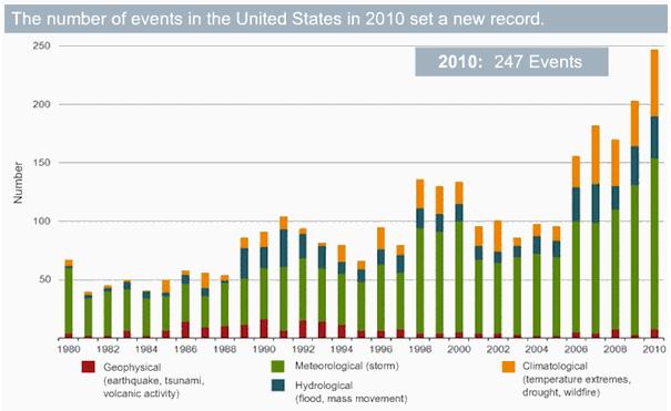

$2 billion: estimated cost of flooding on the Missouri River in 2011. Source: NOAA (story below).

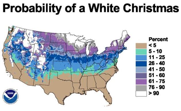
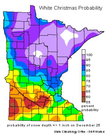
Historical Chances Of A White Christmas. I wouldn't worry too much about Santa and a lack of snow on the ground just yet. The odds are strongly in our favor that we'll have at least 1" or more of snow on the ground by December 24. More details from the Minnesota State Climate Office "Will we have a white Christmas? It's an age-old question that occurs to almost everyone this time of year. The chances of having a white Christmas vary even here in Minnesota. Having a white Christmas is loosely defined as having 1 inch of snow on the ground on Christmas Day. The snow depth at most sites is measured once a day, usually in the morning. The best chances of having a white Christmas is almost guaranteed in the Boundary Waters Canoe Area and a good part of the Arrowhead. The chances decrease to the south and west and the best chance for a "brown" Christmas is in far southwest Minnesota where chances are a little better than 60%. Northern Minnesota is one of the few non-alpine climates in the US where a white Christmas is almost a sure bet (U.S. White Christmas Probabilities)."
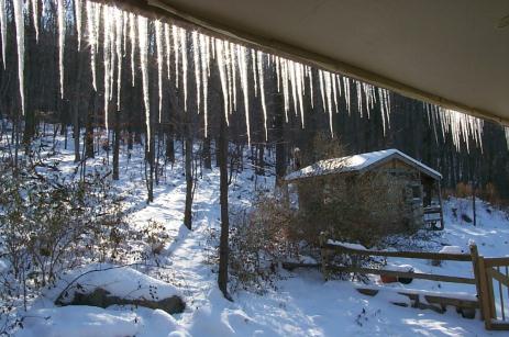
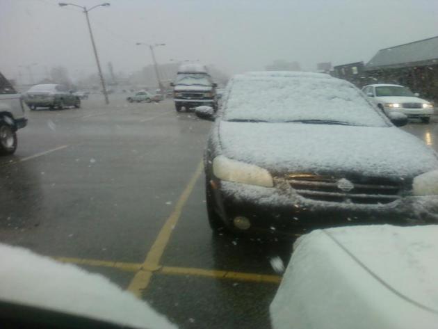
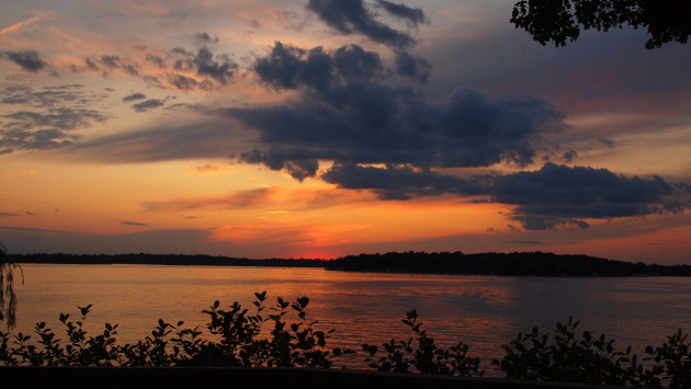
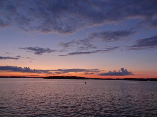
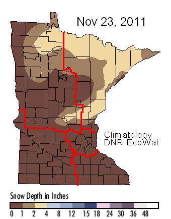


Where's The Snow? As of last Wednesday most of Minnesota was still snow-free, only 1-2" from near Hinckley to Duluth and International Falls. Click here for the latest from the Minnesota DNR.


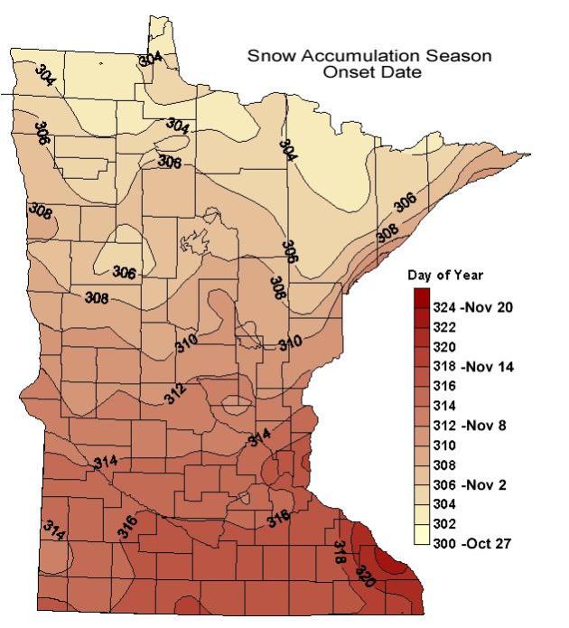
Average Start of Minnesota's "Snow Season". This map, courtesy of the Minnesota State Climatology Office, shows the start of the snow season around November 12 in the Twin Cities, based on data from 1971-1996. The first "blowing snow event capable of drifts" usually arrives on October 27 across the Minnesota Arrowhead, but as late as November 20 close to Winona. More details: "Average start date for the first blowing snow event causing drifts that remain persistent throught the winter. The product was generated using methodology of Tabler and based on the 1971 - 1996 mean monthly temperature records."


Fourth Warmest Thanksgiving On Record For Twin Cities. From the MPX office of the NWS: "The high yesterday at Minneapolis-St Paul was 59 degrees, tying the record high for November 24, set in 1990. It was also the fourth warmest Thanksgiving in Twin Cities history.  The only warmer Thanksgivings have been November 26, 1914 (a high of 62), November 30, 1922 (a high also of 62), and November 30, 1939 (a high of 60). Please see climate.umn.edu/doc/journal/thanksgiving_climatology.htm  for more Thanksgiving Day Climatology. The warmest temperature in Minnesota yesterday was 66 near downtown Redwood Falls.  The second warmest temperature in the state was 65, at Canby and the Redwood Falls airport."

Mr. Skilling is apolitical and understands the risks of speaking out on an issue like global warming, but he feels compelled to. “I questioned it, but it’s happening, no doubt,” he said. “The models have said all along that the Arctic latitudes would warm fastest and spark changes throughout the world......“You’d have to have your head buried in the sand not to say there’s something going on. There’s a mosaic of influences, including human effects, and how you rate them is difficult. But it is going on, and we have to study it.” - from a New York Times article on Tom Skilling below.


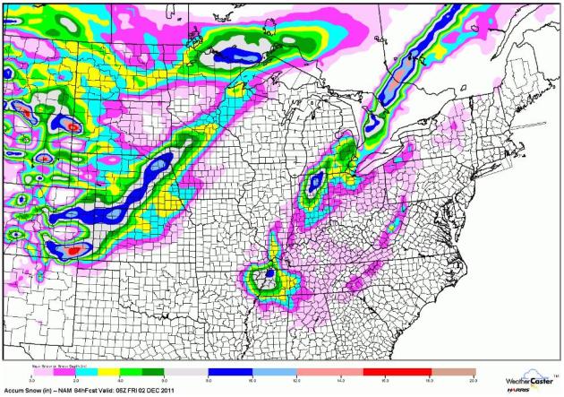
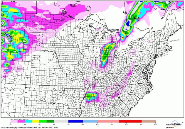
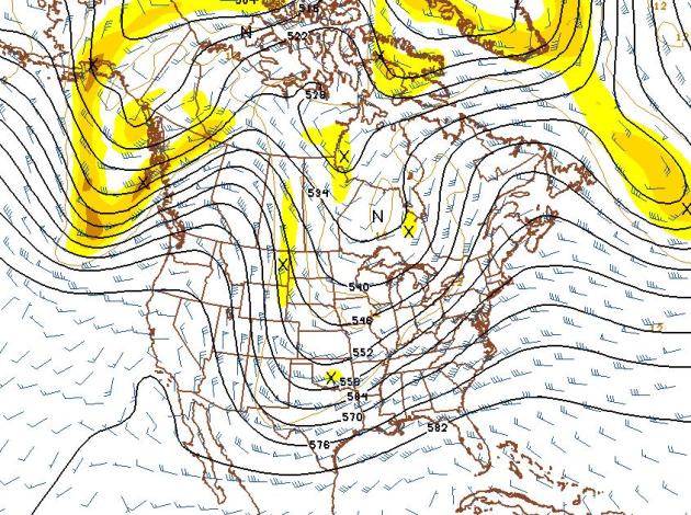
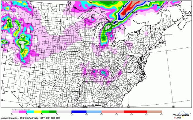
Snow Accumulation Through Midday Thursday. The GFS model is predicting a coating of slush as far south as the hills of northern Alabama and Georgia, some 2-5" lake effect snowfall amounts over Lower Michigan, more accumulating snow predicted west of Denver. An inch of snow may pile up on the Minnesota Arrowhead, closer to the Boundary Waters. Otherwise, a fairly quiet pattern for most of the USA. Map courtesy of WeatherCaster.

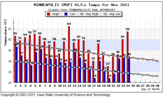
Consistently Warmer Than Average. This graphic from the Iowa Environmental Mesonet (courtesy of the Iowa State University of Science and Technology) shows the November temperature trend for the Twin Cities. For the month temperatures are running more than 3 degrees above average. 59 F. on Thanksgiving Day is pretty impressive for this latitude.

Warm Thanksgiving Day. Here's a good overview of Thursday's amazing warmth from Mark Seeley in his weekly WeatherTalk blog: "November 24th brought the warmest Thanksgiving Day for many Minnesota communities since 1990. Near Redwood Falls the afternoon temperature reached 66 degrees F, just two degrees F shy of the state record for the date (68 F at Wheaton in 1984). But many Minnesota communities reported new record highs yesterday (November 24th) prompting a good deal of outdoor activity for the holiday. Those reporting record highs included: 65 degrees F at Canby; 64 degrees F at Tracy; 61 degrees F at Austin; 60 degrees F at Rochester; 59 degrees F at MSP (tied record); 57 degrees F at Fargo-Moorhead; and 55 degrees F at Detroit Lakes (tied record)."

First Measurable Snowfall Statistics For Chicago and Rockford. From the local NWS office:
CHICAGO...
...122 YEARS OF RECORDS FOR FIRST DATE OF MEASURABLE SNOWFALL.*
...THE AVERAGE DATE OF FIRST MEASURABLE SNOWFALL IS 11/16.
...75 PERCENT OF THE YEARS HAD RECEIVED MEASURABLE SNOWFALL BY 11/25.
...84 PERCENT OF THE YEARS HAD RECEIVED MEASURABLE SNOWFALL BY 12/1.
...EARLIEST DATE OF FIRST MEASURABLE SNOWFALL:10/12/2006.
...LATEST DATE OF FIRST MEASURABLE SNOWFALL:12/16/1965.
LOOKING BACK AT THE 2010-2011 SNOW SEASON...NO MEASURABLE SNOW WAS
RECORDED AT BOTH CHICAGO-O'HARE AND ROCKFORD AIRPORT UNTIL DECEMBER
1ST. IN THE CURRENT FORECAST PERIOD...WET SNOW MAY MIX IN WITH
RAIN SHOWERS LATE SATURDAY NIGHT INTO SUNDAY...BUT NO MEASURABLE
SNOW IS EXPECTED. AFTER THAT...THERE IS A DISTINCT POSSIBILITY
THAT THE FIRST MEASURABLE SNOWFALL OF THE SEASON MAY NOT OCCUR AT
CHICAGO AND ROCKFORD UNTIL AFTER DECEMBER 1ST

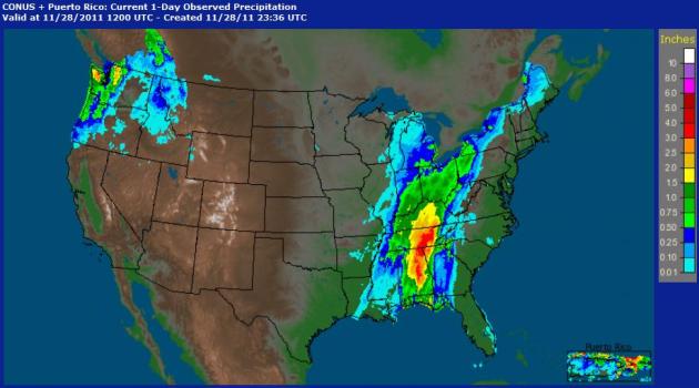
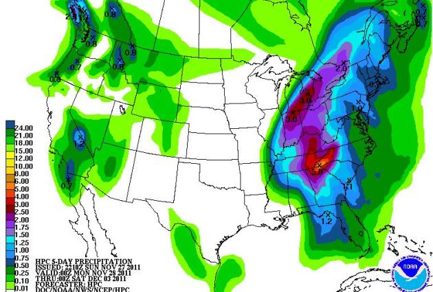
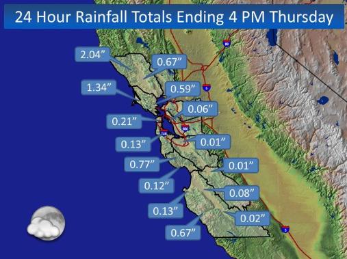
Soggy Pattern For California. I still don't see any significant storms (rain, snow or ice) for the Upper Midwest anytime soon, the core of the jet supressed to the south, favoring storms for the west coast, and parts of the southern and eastern USA. Thanksgiving rainfal amounts above courtesy of the San Francisco National Weather Service office.

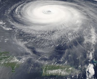
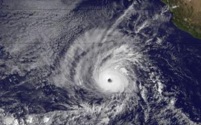
Hurricane Kenneth Sets Record For Eastern Pacific Storms. The Summit County Citizen's Voice has more on last week's record, Category 4 hurricane in the eastern Pacific: Measuring 300 miles across and generating sustained winds of 145 mph, Hurricane Kenneth this week set a record as the latest major hurricane in the eastern Pacific Ocean. More hurricane records are online here. Dr. Jeff Masters, of Weather Underground, also commented on the unusual nature of the 2011 eastern Pacific hurricane season in his blog. Normally, La Niña conditions in the Pacific suppress the formation of intense hurricanes.


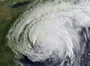
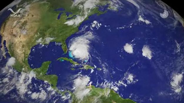
Hurricane Season A Sleeper In Southeast. Savannahnow.com has the story: "Hurricanes are like real estate. The three things that matter most about them are location, location, and location. So as the 2011 hurricane season comes to an end Nov. 30, it looks like a non-event from Savannah’s perspective. The only tangible effects here were high surf and some beach erosion from Hurricane Irene in late August. Otherwise, there was barely a leaf blown out of place. But it was an above-average season with massive damage elsewhere, especially in the Northeast, which is often spared the effects of tropical weather. Overall, the season racked up 18 named storms, the last of which was November’s Tropical Storm Sean. Seven of the storms were hurricanes and three of those were major hurricanes." Image above courtesy of NASA.


Florida Escapes Hit By Major Hurricane For Another Year. The story from Tampa Bay Online: "The squiggly lines of storm paths are everywhere – in the Atlantic Ocean and even the Gulf of Mexico. But none, thankfully, crossed the state of Florida. During a busy hurricane season that saw 18 named storms, with seven of those morphing into hurricanes, the Sunshine State was not impacted a single time. "It was an incredibly good year for us," said Michelle Palmer, deputy state meteorologist for Florida. "We like calm seasons." The only names we didn't make it to in the 2011 list were Tammy, Vince and Whitney. And while hurricane season doesn't officially end until Wednesday, forecasters say we have likely seen the last of tropical activity for the year." (Photo courtesy of NASAWatch).

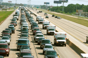
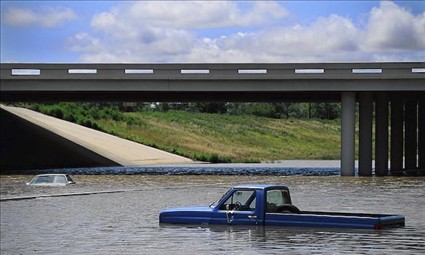
How To Steer Clear Of Flood-Damaged Cars. Looking for a (gently) used car? If you find a deal/price that's too good to be true, check to see if the car or truck was in a flood of any kind. Here's a harrowing story from The Republic: "ORLANDO, Fla. — The hurricane season is almost over for 2011, suggesting that we no longer need to worry about one of the major problems caused by severe storms — flooded cars. Right? Wrong. Unscrupulous brokers have learned that it isn’t smart to try to sell flood-damaged cars just down the road from a major flood. It isn’t that hard to do a quick, cursory reconditioning of a damaged car in one place, then ship it — or a whole truckload of poorly reconditioned cars — to another city or state where consumers wouldn’t suspect. Be aware, too, that it doesn’t require a major, news-making flood to cause damage. A neighborhood flash flood can send vehicles with serious water damage onto the market." (photo above courtesy of MSN, which has more good information on spotting flood-damaged vehicles here).


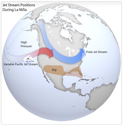
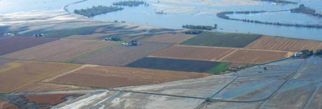
Missouri River Flood Drama Likely Took Direction From La Nina. Did a strong La Nina cooling of Pacific Ocean water last spring contribute to record flooding on the Missouri River? NOAA's Climate Watch has the story: "The Missouri is the continent's longest river. It trickles out of the mountains in Montana and flows east and south toward the Mississippi. Its waters are essential to the basin's farmers and ranchers, who raise 46% of the wheat, 22% of the corn, and 34% of the cattle in the United States. The river is also home to a system of dams, levees and spillways meant to insulate people living in the basin from the river's extremes. But in 2011 they couldn't keep the Missouri completely under control. Beginning in late spring and continuing through the summer, floodwater spilled over the Missouri's banks onto fields and towns, reaching up to five miles from the river's normal edge. The waters finall started to recede this fall, giving the basin's residents their first glimpse of the $2 billion in damages from this slow-moving catastrophe."


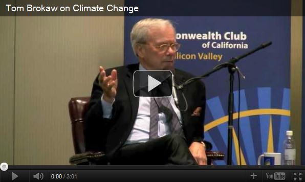
For (Tom) Skilling, There Is No Such Thing As Bad Weather. Let me tell you a quick story about Chicago TV meteorologist Tom Skilling, one that sheds light on what a great (genuine) guy he really is. When I was a wide-eyed meteorology student at Penn State I dropped by the WGN-TV studios in Chicago for a quick tour. Not only did Tom show me all his meteo-toys at the office, but he took my friend and me to his Chicago townhouse, where he had converted a guest bedroom into a weather center, complete with "NAFAX" maps plastered on every wall. I was in weather-heaven. He was and is the epitome of a weather geek/enthusiast - and I say that with admiration and genuine respect. Tom is still at the top of his game. He still makes time to get others excited about meteorology. That, and he doesn't take himself too seriously. If I sound like a groupie, well, maybe, in this (rare) instance, I am. I mean, this guy bought a place in Anchorage so he could be CLOSER TO SNOW! Yes, Tom Skilling is the real deal and it's great to see nice guys (who are passionate about what they do)....do well. The New York Times agrees that Mr. Skilling is a force of nature: "There are many reasons for Chicagoans to wonder what in the name of Harry Volkman is going on with their weather. A blizzard in February dumped 21 inches of snow on the city and closed Lake Shore Drive for three days. A heat wave in July delivered the first 100-degree temperatures in six years. Forecasters are warning of arctic-like conditions in the months ahead — it is going to be another brutal winter. To make sense of it, people are turning to Mr. Skilling in ever greater numbers, if 52,000 Facebook fans and 12,000 Twitter followers are any indication. Since Mr. Skilling succeeded Mr. Volkman as WGN’s chief meteorologist in 1978, the folksy, 59-year-old has become the undisputed king of Chicago weather, with a million-dollar salary, a 12-person staff and stature at his station that is unmatched in the market. His amiable, enthusiastic demeanor is a perfect delivery vehicle for the knowledge and passion he brings to his subject."

Is Apple Working On iTV? It's still pure speculation and conjecture at this point, but the Apple fan boys (myself included) are praying that Apple will ultimately improve on the television experience. I found this blurb interesting from mashable.com: "Apple’s relationship with Samsung has deteriorated, and the Cupertino giant may be working with Sharp on the next generation displays for upcoming devices such as the iPad 3, iPhone 5 and a little something called iTV, claims Jefferies analyst Peter Misek. Since all of these products are unofficial and unannounced, such predictions fall into the realm of speculation. However, Misek claims that the mythical iTV – a future “smart TV” product from Apple that has been the subject of many recent rumors – is a real thing, and Sharp is working on modified amorphous TFT LCD panels for the device."


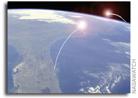
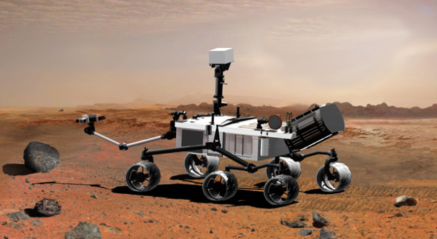
NASA Curiosity Rover On Its Way To Mars. Here's the story from Engadget.com: "It's been described by the scientist in charge as "the most complex mission that has ever been undertaken to the surface of another planet," and NASA's Mars Science Laboratory spacecraft is now well on its way to Mars. An Atlas V rocket carrying the Curiosity rover launched from Cape Canaveral this morning, and a successful separation of the craft occurred in space shortly thereafter, kicking off a journey to Mars that's expected to end with a rocket-powered descent to the planet in August of next year. (Image above courtesy of NASA).


Climate Stories...


What's New (And What Isn't) In IPCC's Report On Extreme Weather? Inside Climate News has the story: "Severe weather in the United States and elsewhere has grown more frequent since 1980. Contributing to the shift is the accumulation of heat-trapping carbon dioxide in the air from human activities—though teasing out the exact contribution is tricky..... Droughts are more frequent and longer, particularly in southern Europe and West Africa, it found. As well, the frequency of days with heavy precipitation is up in some regions (warmer air holds more moisture). Tropical cyclones, the generic term for typhoons and hurricanes, have shifted poleward in recent years; and, as a result, storms have made landfall in areas that previously didn't lie in the tracks of cyclones. The IPCC said it is "likely"—a 66 percent to 100 percent probability—that the temperature and precipitation trends mentioned above are caused by a rise in greenhouse gas emissions from human activities like burning fossil fuels and deforestation. They are less certain about cyclones because of spotty historical records." Photo courtesy of NOAA.

U.N. Extreme Weather Report Triggers Storm Of Protest. Here's an excerpt from Der Spiegel: "The report says that one "very likely" trend is that heat waves will occur more frequently and last longer around the world and that an increase in the frequency and magnitude of warm days and nights around the globe is "virtually certain." By the end of the century, the report predicts, temperatures on days with extreme heat will be between 2 and 5 degrees Celsius (3.5 and 9 degrees Fahrenheit) higher than they are today. The report is more cautious in what is says about heavy rainfalls. "There is medium confidence," it says, "that, in some regions, increases in heavy precipitation will occur despite projected decreases of total precipitation in those regions."


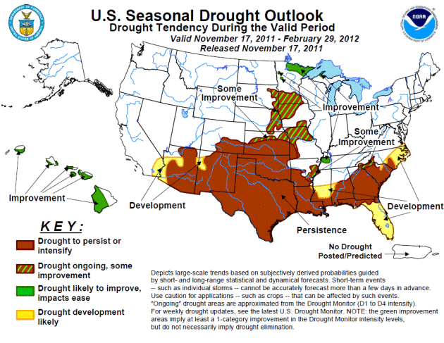
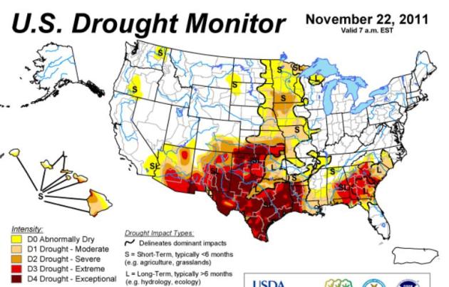
Drought Puts Damper on Tree Farmer's Christmas. AP has the story. Here's an excerpt: "NEW CANEY, Texas (AP) — Dry, brown grass crunches underfoot as David Barfield walks through his 45-acre Christmas tree farm pointing at evergreens covered with brittle, rust-colored needles. "Dead tree, dead tree, dead tree," he says, shaking his head at dry timber he hoped would be chopped down by parents with excited children. Instead, Mother Nature delivered the Grinch in the form of a historic drought that has killed thousands of trees across Texas and Oklahoma. Some died of thirst. Others were destroyed by wildfires, whose breadth and intensity were magnified when wind swept the flames across parched landscape."