Monday, October 31, 2011

November 1: Storm Watch for Denver (more on record-smashing "Snow-tober" storm)


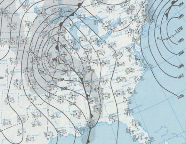
2011 Firearm Deer Hunting Opener Outlook: windy with (rain) showers, highs in the 50s; winds gusting to 30 mph. Wet snow possible over far northwestern MN, Red River Valley into eastern North Dakota, where several inches of snow may accumulate. Click here for more information from the Minnesota DNR.


"Oh wow. Oh wow. Oh wow." Steve Jobs' last words before his death, as reported by his sister, Mona Simpson, in a deeply moving eulogy in the New York Times.


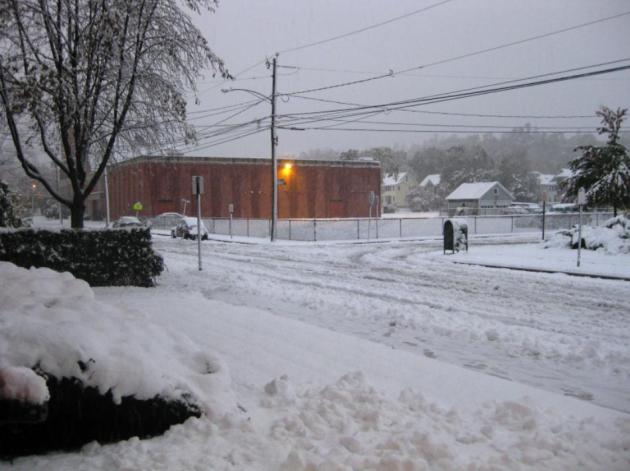
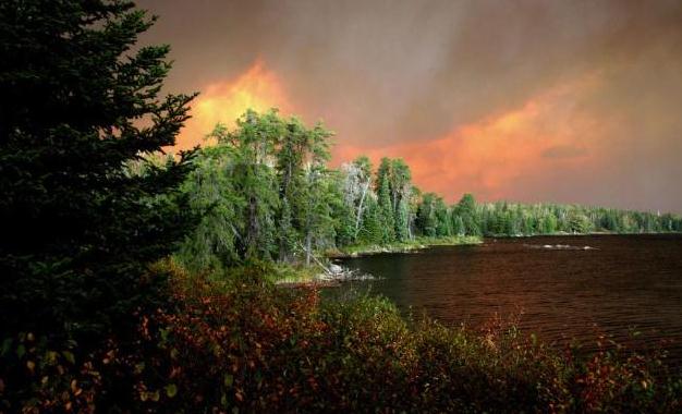
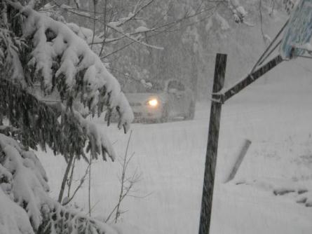
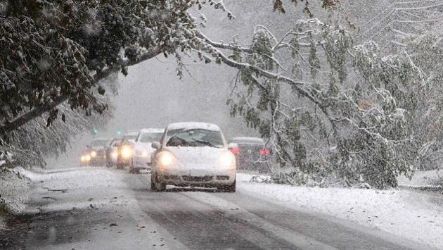
Snowy Wonderland. Thanks to Nicholas Isaac from Bristol, Connecticut for passing on this photo (he just got power back and was able to send in some photos)

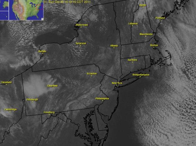
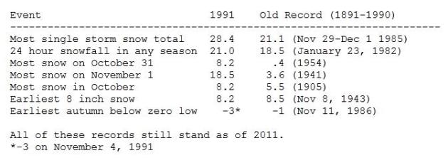
Historic "Snowtober" in the Northeast:

* Earliest snow.
* Most snow.
* Earliest snow days at area schools from Maine to Virginia.
* Record state power outages.

(source: CNN)

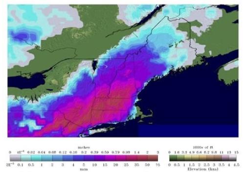
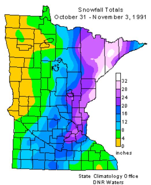
"Widely referred to by its social media moniker, “Snowtober,” the storm smashed records that had stood since the beginning of the reliable instrument record in the late 1800s (and in some cases, even longer than that), and upended assumptions about what a fall nor’easter can do." - Capital Weather Gang story about the record October snowfall below.

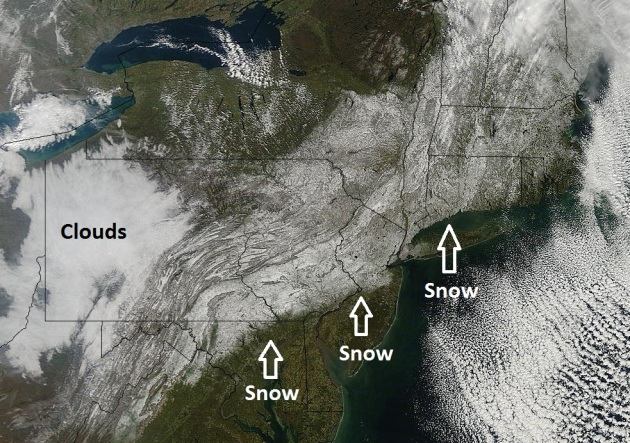
86% of northeastern USA had 4" or more of snow on Halloween. Photo above courtesy of The Morning Call).

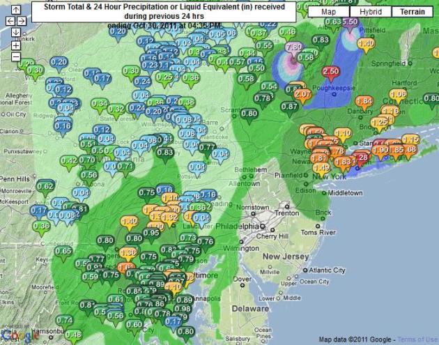
31.4" snow: Golden Snow Shovel Award goes to the town of Jaffrey, Massachusetts, where over 2 1/2 feet of snow piled up.

22.5" snow at Concord, New Hampshire: second greatest 24 hour snowfall (in any month). Source: Capital Weather Gang.

2.9" Central Park, New York City: only time in New York City history where an inch or more has been reported in October.

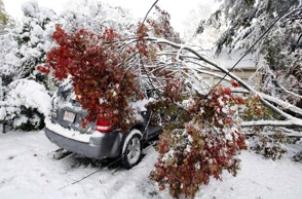
Nearly 1,000 trees may be lost in Central Park due to Saturday's heavy wet snow (New York Times).
"The most extraordinary October snowstorm in over two centuries in the Northeast U.S. has finally come to an end this Sunday afternoon. Not since the infamous snow hurricane of 1804 have such prodigious amounts of snow been recorded in New England and, to a lesser extent, in the mid-Atlantic states. In fact, the snowfall, in most cases, has exceeded that of even the great October snow of 1804." - Christopher Burt, weather historian, courtesy of Dr. Jeff Master's WunderBlog.

Snowy Stripe. Over a foot of snow piled up from the hills of northern Virginia, West Virginia and western Maryland northward to Pennsylvania and much of New England. Map courtesy of NOAA's NOHRSC Interactive Snow Information products available here. Graphic above courtesy of Capital Weather Gang and NOAA.


Historic October Northeast Storm: Epic. Incredible. Downright Ridiculous. Once again meteorologists are scratching their heads over the freakishly intense super-storm that submerged tens of millions of Americans in the northeast under 4-24" of snow. Andrew Freedman from the Washington Post's Capital Weather Gang has a good overview: "Perhaps no combination of superlatives could do justice to the historic snowstorm that delivered a crippling wallop to parts of the mid-Atlantic and Northeast over the weekend. Widely referred to by its social media moniker, “Snowtober,” the storm smashed records that had stood since the beginning of the reliable instrument record in the late 1800s (and in some cases, even longer than that), and upended assumptions about what a fall nor’easter can do. The heavy, wet snow pasted onto trees still bearing foliage in many areas and weighed down power lines, knocking out power to at least three million people in the region. "


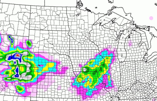
Getting Closer. A Winter Storm Watch is posted for the Denver area for 4-8" of snow from tonight into Wednesday. A wave of low pressure rippling northeast along an advancing cold front may squeeze out a few inches of snow from near Kansas City to Des Moines the Quad Cities to Rockford and Madison.


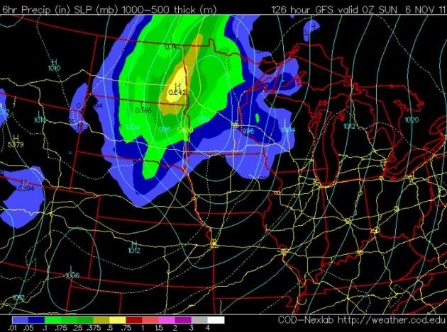
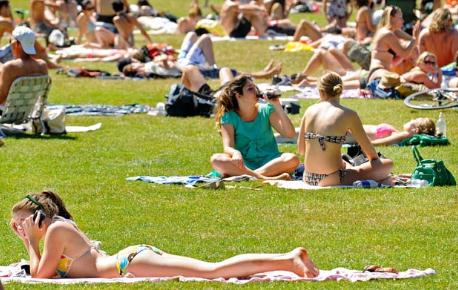
Saturday: Warm Enough For Rain. Models spin up an impressive storm for the weekend, but a storm track well west of the Twin Cities will place most of Minnesota on the warm side of the storm, highs in the 50s with rain showers likely. Wet snow is possible north/west of Detroit Lakes and Thief River Falls, from Fargo/Moorhead north to Crookston, and as much as 3-6" snow may accumulate over the central and eastern Dakotas. The farther north/west you go, the better the odds of enough snow for tracking.

October Storm's Power Outages Top Hurricane Irene's Numbers. Pennlive.com has the story: "Last month, Hurricane Irene left more than 260,000 PPL customers without power. The rare October nor’easter that on Saturday dumped 5.5 inches of heavy snow in the Harrisburg area was worse. Saturday’s storm left 315,000 PPL customers in central and eastern Pennsylvania and 257,000 Met-Ed customers without electricity. By 7:15 p.m. Sunday, PPL still had 150,000 customers without electricity in its 29-county region, including 1,995 in Cumberland County, 3,027 in Dauphin County, 1,003 in Lebanon County, 1,288 in Perry County and 1,998 in York County. The outages occurred when leaf-laden trees bent and broke under the heavy snow and fell on power lines and poles. In a company statement, PPL called the Lehigh Valley the hardest-hit region, with 125,000 customers affected, followed by the Harrisburg and Lancaster areas."


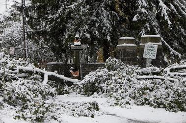
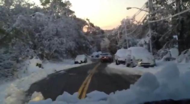
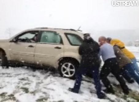
Widespread Damage. Millions without power, some people may be in the dark through the end of the week. Tens of thousands of trees may have been damaged or destroyed by the freak, early-season snowfall. Heavy and wet it accumulated on leaves (that had yet to fall from trees), making a bad situation even worse. Check out this YouTube footage of damage in upstate New York. Unbelievable.

Saturday's Record Snowfall From Space. With a little practice you can differentiate cloudcover from freshly fallen snow. Snow on the ground traces river valleys and mountain ridges - clouds tend to be brighter, an even shade of white. Map courtesy of Ham Weather.


Close-Up. Here's a high-res image from NASA's low-orbiting "Modis/Terra" satellite, which orbits the Earth a little more than 200 miles above the ground. Downtown Baltimore and Washington just missed the accumulating snow, but smudges of fresh snow are visible in metro New York.


Precipitation Amounts. NOAA has a terrific tool that tracks rainfall and snowfall amounts. Close to 2" of liquid precipitation fell on Long Island from Saturday's storm.


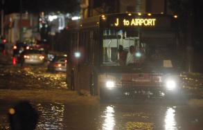
Flash Flood Warnings Issued For Miami-Dade. South Florida has seen soaking rains and considerable flash flooding in recent days. The Miami Herald has more details: "The respite from rain won’t last long. Though floodwaters slowly began receding Monday morning, more storms were expected to sweep across South Florida in the afternoon — some of them torrential enough to quickly turn streets and already saturated suburban yards into lakes once again. Most of South Florida was under a flood watch and just before noon the National Weather Service issued a flash flood warning for East Central Miami-Dade County as a band of intense cells approached from the south. “It’s been dry this morning but we do have some additional rain moving into the area this afternoon, some of it heavy,’’ said Robert Molleda, warning coordination meteorologist for the service’s Miami office. Some areas could see another one to two inches, maybe much more, to go on top of a weekend that produced double-digit rainfall amounts from Coral Gables to Fort Lauderdale. The rain could extend into the early evening, making for a soggy Halloween outing."

Fire Service Way Off On BWCA Fire Projections. The Star Tribune has the story: "ELY, MINN. — A series of internal reports show that the U.S. Forest Service repeatedly underestimated the explosiveness of the Pagami Creek Fire during a critical 18-day stretch of late August and early September, allowing a half-acre burn to grow into a massive firestorm that left eight people fighting for their lives inside the Boundary Waters Canoe Area Wilderness. As a result, officials failed at several goals established in their own fire management memos early on, records show. When the fire's signature phase erupted on Sept. 12, the blaze took off on a stunning 16-mile run that vaporized trees and turned into Minnesota's biggest forest fire since 1918. On a lake left unpatrolled by the Forest Service, two campers fought for their lives while trapped in a downpour of red-hot embers, blinding smoke and superheated gasses."


Products R Us. Are We "Brandwashed". Here's an interesting story from NPR: "Martin Lindstrom got into the advertising business early on. "I started up my own ad agency when I was 12 years old," he tells Guy Raz, host of weekend on All Things Considered. "I was a huge fan of Lego, so I built up my own Legoland in the backyard of my mom and dad's garden." No one showed up on the first day, but Lindstrom persuaded a local ad agency to sponsor him. On the third day, he had 131 visitors. The only problem? "Visitor number 130 and visitor 131 were the lawyers from Lego suing me." Since then, Lindstrom has learned a few things about advertising and marketing. He's advised major corporations such as Disney and Proctor & Gamble, and recently wrote a book called Brandwashed, which chronicles the many ways corporations get us to consume their products."


Weather: Cloudy With A Chance Of Stalking. Yes, some of these apps know EXACTLY where you are at any given time. Great for serving up a relevant ad, but it turns out that many people aren't fond of digital stalking. Paidcontent.org has the story: "It’s like being followed by the weatherman. A new class action suit against HTC makes some unsettling allegations about how the phone maker has been using a built-in weather app. In a suit filed in Seattle federal court, two plaintiffs claim that their phone’s AccuWeather app is transmitting precise data about their location at regular intervals and whenever they tap to check the weather. They say the app, which is built into the phone, can’t be disabled and that phone maker HTC is sharing the location data with advertisers that want to target users with customized ads. The plaintiffs also say HTC is failing to encrypt the data that transmits their location. According to the complaint, the AccuWeather app, which is also available for the iPad, collects location information that is more precise than necessary to provide weather information. Rather than simply collecting “coarse information” to learn that a person is in a certain part of the city, the app obtains the precise corner at which he or she is standing at a given time. The complaint says this information is useful to AccuWeather because the company is in the business of selling user profiles gleaned from smartphone data."


23 Amazing Carved Pumpkins. OK. Someone has entirely too much free time on their hands - but these are very cool. Thanks to The Daily Beast, which has all the details.


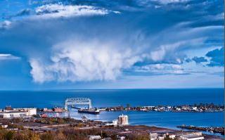
Photo Of The Day: Cumulus Congestus. It's unusual to have these vertically-stretched instability cumulus clouds in October, but a pool of unusually cold air in the upper atmosphere left skies over Duluth unusually unstable. That's snow falling out of those clouds. Photo courtesy of Shawn Thompson Photography.


Climate Stories...


Climate Researchers Warn Of Data Crisis. Nature has the story: "Climate scientists warn that critical gaps in climate data could open up after the current generation of Earth-observation satellites comes to the end of its life, with the next generation nowhere near ready to take over. The problem is exacerbated by the lack of an adequate replacement for a pair of Earth-observation satellites, the Orbiting Carbon Observatory and Glory, which failed on launch in the past two years. Earth-observation programmes will fail to provide the data continuity required for climate science unless they are more adequately managed and supported, Kevin Trenberth, a senior researcher at the US National Center for Atmospheric Sciences in Boulder, Colorado, told the World Climate Research Programme conference in Denver, Colorado, this week. "We cannot manage what we can't measure," he says."


Special Investigation: Who's Behind The "Information Attacks" On Climate Scientists? The Institute for Southern Studies has more: "This week, in a courtroom in Prince William County, Virginia, a hearing will take place that could have implications for the privacy rights of scientists at colleges and universities across the country. It's part of a lawsuit brought by the American Tradition Institute, a free-market think tank that wants the public to believe human-caused global warming is a scientific fraud. Filed against the University of Virginia, the suit seeks emails and other documents related to former professor Michael Mann, an award-winning climate scientist who has become a focus of the climate-denial movement because of his research documenting the recent spike in earth's temperature. By suing the university, the American Tradition Institute wants to make public Mann’s correspondence in an effort to find out whether he manipulated data to receive government grants, a violation of the state’s Fraud Against Taxpayers Act. But a Facing South investigation has found that the Colorado-based American Tradition Institute is part of a broader network of groups with close ties to energy interests that have long fought greenhouse gas regulation. Our investigation also finds that ATI has connections with the Koch brothers, Art Pope and other conservative donors seeking to expand their political influence."


Humans "Locked In" To Warmer World, But Can Still Avoid Dangerous Climate Change. The story from the Montreal Gazette: "Humans have "locked in" future generations to a warmer world but can still prevent "dangerous" climate change by scaling back emissions of carbon dioxide and other greenhouse gases that trap heat in the atmosphere, wrote scientists in a newly-released internal memorandum to the top bureaucrat at Environment Canada. “Immediate cessation of CO2 emissions . . . cannot have a large near-term effect on global temperatures,” said the memorandum, drafted in April by Environment Canada scientists Greg Flato and Elizabeth Bush. “Our past emissions have essentially ‘locked in’ the warming experienced to date, committing future generations to a warmer world. The real issue is that ongoing emissions lead to ongoing increases in atmospheric CO2 and therefore ongoing warming.”

Sunday, October 30, 2011

National Weather Headlines for Halloween Monday October 31st

Photo Courtesy: Star Tribune

Can you recall what you were doing 20 years ago today? I can... I was 9 years old getting ready to go trick or treating as a cow. It was a homemade costume that my mom made and I'm happy she put lots black spots on there otherwise, I would have gotten lost in the snow.

The Legendary Storm
 
The Storm Track
 
     It was a storm of legendary proportions that broke man records across the state. The storm was classified as a "Bomb", deepening 24 millibars within 24 hours as it moved from just north of St. Louis, MO to the Keweenaw Peninsula in the U.P. of Michigan. The central pressure of the low was similar to a category 1 or 2 hurricane.

Snow Totals

MSP Snow Records From 1991


 The northwest flank of the storm kept Minnesota and Wisconsin in the heavy snow corridor. Minneapolis picked up a whopping 28.4" of snow from the storm, which still holds the record for the single biggest snowstorm in recorded history at MSP. Duluth had 36.9" from the event, which was the single storm state record up until 1994 when 47" fell in the Arrowhead.

Here's a link to the 20th anniversary of the Halloween Blizzard of 1991


Here's a link to the Halloween Blizzard from the National Weather Service in Duluth, MN

photo courtesy: inquisitir.com

     Other than the witch watch and the werewolf warning, there's nothing spooky about trick or treating weather today. 2 storms look to take shape this week,  the more significant one moves in the the weekend - Todd Nelson


Here's a link to Halloween Climatology for MSP from the State Climatology Office


Record Snow Comes to the Northeast
A quick hitting storm in the Northeast left millions without power as record wet, heavy October snow fell on Saturday. Thanks to Christine Dwyer from Becket, Mass. for the picture below:

Northeast Snowfall Map
The golden snow shovel award goes to parts of New England and Massachusetts.
 
Northeast Snow Seen From Space
The fast moving storm was gone by Sunday, allowing the carpet of white to been seen from nearly 23,000 miles high via satellite.

Millions Without Power
"Millions of people from Maine to Maryland were without power as an unseasonably early nor'easter dumped heavy, wet snow over the weekend on a region more used to gaping at leaves in October than shoveling snow."

Photo Courtesy: Christine Dwyer from Becket, Mass.
Here's another great shot from Christine

The Week Ahead
I'm looking at 2 potential systems this week. The first will slide through midweek, start with a little rain and possibly mix in will a little wet snow (north) at the tail end early Wednesday.

The Bigger Storm??
The second (potential) storm looks quite a bit more interesting, especially since next weekend is the MN deer hunting opener (rifle). There will be thousands of folks out in the woods next weekend and if the latest forecast holds, there might be a lot of wet, wind blown and maybe even white deer hunters depending upon location. This one will be one to watch... Below is one of the potential solutions for next Saturday - YIKES!

Thanks for checking in, have a great Halloween!
Meteorologist Todd Nelson

Saturday, October 29, 2011

October 30: Historic Northeast Snowstorm (earliest snow since Civil War for New York City)

1.3" Central Park in New York City. Snowiest October since records were first kept in 1869.
Thunder-snow reported at Harrisburg, PA yesterday.
15" snowfall estimate in Lancaster, PA (thanks to weather spotter Volker Kruhoeffer for providing that report).
42 F. high in Baltimore and Washington D.C. (Reagan Airport) Saturday, coldest October 29 ever recorded.
Snow has fallen in Washington D.C. only 15 times in October since the late 1800s (Capital Weather Gang).


Snow Blitz! A scene from Lodi, New Jersey. Governor Chris Christie declared a State of Emergency for much of New Jersey. Photo courtesy of the Daily Mail.

·  Earliest New York City one-inch snowfall since records began.
·  Pennsylvania 84-year-old man dies as tree crashes into his home as he has had a nap. Another dead in Connecticut
·  More than 250,000 customers lost power in Pennsylvania and Maryland
·  More than 1,000 flights in or out of America cancelled
·  Experts predict up to 10 inches of snow to fall across North East
·  Only fourth time since Civil War that snow has fallen in NYC in October

* Winter storm factoids above courtesy of the Daily Mail.

It is unusual to have a storm of this intensity affect the mid-Atlantic and the Northeast” at this time of year, said National Weather Service spokesman Chris Vaccaro. “This is more like a February storm as opposed to an October storm.” - from a Washington Post article on Saturday's freakish October snowstorm.


Historic Northeast Storm. Saturday's storm is breaking records from Virginia to Maine, impacting tens of millions of Americans. AccuWeather.com has more details: "Heavy, tree-breaking, travel-snarling, record-breaking snow will continue to spread across the Northeast tonight. The snow is moving southwest to northeast across the region, creating an early season winter wonderland but a nightmare for travelers and power companies. By the time the snow winds down Sunday morning, between 6 and 12 inches of snow will cover places from central and eastern Pennsylvania to eastern Maine."

Atmospheric Omen? I'm starting to wonder if another La Nina pattern may just favor the biggest storms for the east coast again this winter. It's too early to reach profound conclusions - we won't really know what kind of blocking patterns are setting up until late November or December. But the east coast just got pasted by heavy rain, snow and coastal flooding - a few more coastal storms are brewing over the next 1-2 weeks, and this may be a premonition of wild and wintry storms to come from Atlanta to D.C. to New York and Boston. We'll see. Just a gut feel (nausea?)


I Thought This Thing Had All-Wheel Drive! Thanks to WeatherNation meteorologist Kristin Clark, who braved moderate snow in State College, PA to take in a Penn State - Illinois football game with some friends. No, she wasn't the one getting pushed out of a snowy rut.


PUBLIC INFORMATION STATEMENT
SPOTTER REPORTS
NATIONAL WEATHER SERVICE NEW YORK NY
549 PM EDT SAT OCT 29 2011

THE FOLLOWING ARE UNOFFICIAL OBSERVATIONS TAKEN DURING THE STORM
THAT HAS BEEN AFFECTING OUR REGION.  APPRECIATION IS EXTENDED TO
HIGHWAY DEPARTMENTS...COOPERATIVE OBSERVERS...SKYWARN SPOTTERS AND
MEDIA FOR THESE REPORTS.  THIS SUMMARY IS ALSO AVAILABLE ON OUR HOME
PAGE AT WEATHER.GOV/NYC

...RECORD OCTOBER SNOWFALL AMOUNT SET FOR CENTRAL PARK NY...

AS OF 2 PM TODAY...CENTRAL PARK RECORDED 1.3 INCHES OF SNOWFALL.
SINCE SNOWFALL RECORDS BEGAN IN 1869...AN INCH OF SNOWFALL HAS NEVER
BEEN RECORDED IN THE MONTH OF OCTOBER. THE LAST TWO TIMES THAT
MEASURABLE SNOW FELL IN THE MONTH OF OCTOBER WAS...OCTOBER 21 1952
WITH 0.5 INCHES AND OCTOBER 30 1925 WITH 0.8 INCHES.
THEREFORE...THIS BREAKS THE DAILY RECORD FOR SNOWFALL IN OCTOBER AND
THE MOST SNOWFALL EVER RECORDED IN THE MONTH OF OCTOBER.

********************STORM TOTAL SNOWFALL********************

LOCATION          STORM TOTAL     TIME/DATE   COMMENTS
                     SNOWFALL           OF
                     /INCHES/   MEASUREMENT

CONNECTICUT

...FAIRFIELD COUNTY...
   RIDGEFIELD            10.0   450 PM 10/29  PUBLIC
   DANBURY                8.9   500 PM 10/29  SKYWARN SPOTTER
   MONROE                 7.0   249 PM 10/29  PUBLIC
   SHELTON                6.8   530 PM 10/29  PUBLIC
   BROOKFIELD             6.0   500 PM 10/29  SKYWARN SPOTTER
   GREENWICH              5.0   351 PM 10/29  SKYWARN SPOTTER
   NEWTOWN                5.0   323 PM 10/29  SKYWARN SPOTTER
   NORWALK                3.5   330 PM 10/29  PUBLIC
   BRIDGEPORT             2.5   326 PM 10/29  COOP OBSERVER
   DARIEN                 2.0  1255 PM 10/29  SKYWARN SPOTTER
   STAMFORD               2.0   145 PM 10/29  SKYWARN SPOTTER
   STRATFORD              1.3   119 PM 10/29  PUBLIC

...MIDDLESEX COUNTY...
   HADDAM                 2.0   523 PM 10/29  PUBLIC

...NEW HAVEN COUNTY...
   OXFORD                 8.5   531 PM 10/29  PUBLIC
   SEYMOUR                7.0   457 PM 10/29  PUBLIC
   NORTH HAVEN            6.2   536 PM 10/29  SKYWARN SPOTTER
   MERIDEN                4.0   412 PM 10/29  PUBLIC
   NEW HAVEN              1.1   233 PM 10/29  PUBLIC
   EAST DERBY             1.0   234 PM 10/29  PUBLIC

NEW JERSEY

...BERGEN COUNTY...
   TENAFLY                4.3   516 PM 10/29  COOP OBSERVER
   SADDLE BROOK           4.3   532 PM 10/29  SKYWARN SPOTTER
   RIDGEWOOD              4.0   532 PM 10/29  SKYWARN SPOTTER
   MIDLAND PARK           4.0   336 PM 10/29  PUBLIC
   RIDGEFIELD             4.0   130 PM 10/29  PUBLIC
   RAMSEY                 3.3   532 PM 10/29  SKYWARN SPOTTER
   DUMONT                 3.0   319 PM 10/29  NWS EMPLOYEE
   RIVERVALE              2.5   245 PM 10/29  COOP OBSERVER
   WYCKOFF                1.9   532 PM 10/29  SKYWARN SPOTTER
   GARFIELD               1.2   138 PM 10/29  SKYWARN SPOTTER

...ESSEX COUNTY...
   VERONA                 6.0   446 PM 10/29  PUBLIC
   CEDAR GROVE            5.3   452 PM 10/29  PUBLIC
   WEST ORANGE            5.0   351 PM 10/29  PUBLIC
   BELLEVILLE             4.9   516 PM 10/29  SKYWARN SPOTTER
   NEWARK AIRPORT         2.7   300 PM 10/29  FAA CONTRACT OBSERVER

...HUDSON COUNTY...
   HARRISON               3.1   530 PM 10/29  SKYWARN SPOTTER
   HOBOKEN                1.0   333 PM 10/29  SKYWARN SPOTTER

...PASSAIC COUNTY...
   WEST MILFORD          12.5   523 PM 10/29  SKYWARN SPOTTER
   RINGWOOD               8.8   511 PM 10/29  SKYWARN SPOTTER
   WAYNE                  5.8   532 PM 10/29  SKYWARN SPOTTER
   HAWTHORNE              3.5   424 PM 10/29  SKYWARN SPOTTER

...UNION COUNTY...
   ROSELLE PARK           4.8   532 PM 10/29  SKYWARN SPOTTER
   ELIZABETH              3.4   411 PM 10/29  PUBLIC

NEW YORK

...BRONX COUNTY...
   BRONX                  2.2   421 PM 10/29  PUBLIC

...KINGS COUNTY...
   SHEEPSHEAD BAY         1.0   130 PM 10/29  SKYWARN SPOTTER

...KINGS (BROOKLYN) COUNTY...
   SHEEPSHEAD BAY         2.0   442 PM 10/29  SKYWARN SPOTTER

...NASSAU COUNTY...
   MINEOLA                4.0   503 PM 10/29  SKYWARN SPOTTER
   NORTH MASSAPEQUA       1.0   330 PM 10/29  PUBLIC

...NEW YORK COUNTY...
   NEW YORK               1.8   254 PM 10/29  PUBLIC AT W 85TH ST

...NEW YORK (MANHATTAN) COUNTY...
   CENTRAL PARK           1.3   200 PM 10/29  CENTRAL PARK ZOO

...ORANGE COUNTY...
   HARRIMAN               8.3   445 PM 10/29  SKYWARN SPOTTER
   WARWICK                8.0   448 PM 10/29  SKYWARN SPOTTER
   MONROE                 7.3   530 PM 10/29  PUBLIC
   MIDDLETOWN             7.0   520 PM 10/29  PUBLIC
   GOSHEN                 5.0   345 PM 10/29  EMERGENCY MANAGER
   NEW WINDSOR            4.5   300 PM 10/29  PUBLIC
   SOUTH BLOOMING GROVE   3.0   226 PM 10/29  SKYWARN SPOTTER
   GREENWOOD LAKE         3.0   248 PM 10/29  PUBLIC
   CORNWALL LANDING       3.0   323 PM 10/29  SKYWARN SPOTTER
   NEWBURGH               3.0   225 PM 10/29  SKYWARN SPOTTER

...PUTNAM COUNTY...
   MAHOPAC                6.5   432 PM 10/29  PUBLIC
   BREWSTER               6.0   537 PM 10/29  SKYWARN SPOTTER
   PUTNAM VALLEY          1.5   247 PM 10/29  COOP OBSERVER

...QUEENS COUNTY...
   LAGUARDIA AIRPORT      1.0   200 PM 10/29  FAA CONTRACT OBSERVER
   NYC/JFK AIRPORT        0.3   200 PM 10/29  FAA CONTRACT OBSERVER

...RICHMOND COUNTY...
   ELTINGVILLE            0.5   100 PM 10/29  PUBLIC

...ROCKLAND COUNTY...
   NEW CITY               5.0   420 PM 10/29  PUBLIC
   STONY POINT            3.0   323 PM 10/29  SKYWARN SPOTTER

...SUFFOLK COUNTY...
   OAKDALE                0.3   208 PM 10/29  PUBLIC
   ISLIP                    T   200 PM 10/29  FAA CONTRACT OBSERVER

...WESTCHESTER COUNTY...
   ARMONK                 7.5   357 PM 10/29  PUBLIC
   HASTINGS-ON-HUDSON     6.0   453 PM 10/29  PUBLIC
   VALHALLA               5.0   300 PM 10/29  PUBLIC
   SOMERS                 4.5   422 PM 10/29  PUBLIC
   VERNON PARK            4.0   255 PM 10/29  SKYWARN SPOTTER
   YONKERS                4.0   256 PM 10/29  COOP OBSERVER
   RYE                    2.5   113 PM 10/29  PUBLIC
   SCARSDALE              1.5   100 PM 10/29  SKYWARN SPOTTER
* Thanks to NOAA and Earth Networks for the NYC snowfall update.
The Halloween Superstorm of 1991. Where were you on October 31, 1991? If you were in Minnesota at the time I'm betting you have an interesting story to share. Everyone remembers where they were, what they were doing, when the biggest single storm in Minnesota history (since the early 1800s) stalled out over Lake Superior, dumping nearly 30" snow on the metro area. Over 900 Minnesota schools shut down, commuting was impossible - our legendary snow-removal system simply couldn't keep up with the volume of snow. A New England storm (the inspiration behind "The Perfect Storm" stalled offshore, which caused Minnesota's storm to slow down and temporarily stall out over Lake Superior, prolonging the heavy snow over eastern Minnesota. Here's a quick recap from the local NWS office: "As Halloween dawned back in 1991, some wintery weather was anticipated but no one was expecting a blizzard. The National Weather Service issued a Winter Storm Watch at 4:00 am on the 31st with a potential of a foot of snow. The first inkling that the forecast underprojected snowfall totals came when precipitation started falling as snow at about 11:30am in the Twin Cities, much earlier than anticipated. With the realization that the precipitation would be snow, not rain, a Winter Storm Warning was issued during the day by the National Weather Service in the Twin Cities and forecasters realized there was a potential for a lot of snow. As the afternoon faded into evening a surreal scene unfolded with kids attempting to trick or treat wearing coats and boots and pumpkins becoming covered with a snowy blanket. 8.2 inches of snow fell by midnight on the 31st at the Twin Cities International Airport, the most for the entire month of October on record for the Twin Cities."

* Click here for a great recap of the Halloween Superstorm from the Minnesota State Climate Office.

One For The Ages. Chances are we will never experience another storm like the one that struck October 31 - November 2, 1991. A huge swatch of eastern Minnesota picked up in excess of 2 feet of snow, nearly 37" fell in Duluth (with 5-8 foot drifts). Map courtesy of the State Climatology Office, DNR Waters.

Twin Cities Record Broken By Halloween 1991 Storm. This is one impressive list, compliments of the MN State Climatology Office.

More Records. Wikipedia has a good recap of the Halloween Superstorm. Records fell from Omaha and Sioux Falls to Duluth, but the Twin Cities saw the most records - wintry milestones which will probably not be repeated in our lifetime.

Top 50 Scary Halloween City Names. Realtor.com has the list of unfortunately-named towns around the USA. There's actually a "Hell, Michigan". Who knew?


1. Accident, Maryland
2. Bad Axe, Michigan
3. Badwater, California
4. Bat Cave, North Carolina
5. Bitter Springs, Arizona
6. Boos, Illinois
7. Casper, Wyoming
8. Chocolate Bayou, Texas
9. Cut Off, Louisiana
10. Deadwood, Oregon
11. Devils Elbow, California
12. Devils Elbow, Missouri
13. Devils Lake, North Dakota
14. Dripping Springs, Texas
15. Echo, Minnesota
16. Egg Harbor City, New Jersey
17. False River, Louisiana
18. Frankenstein, Missouri
19. Frostproof, Florida
20. Gnaw Bone, Indiana
21. Half Hell, North Carolina
22. Hazard, Nebraska
23. Hell, Michigan
 
Remnant Of Hurricane Rina Shuffles More Cruise Ship Itineraries. USA Today has the story: "Industry giant Carnival plans to re-route three more cruise ships over the coming week due to Rina, the once-powerful storm that caused itinerary changes at a number of lines this week. Carnival tells USA TODAY the Saturday sailing of the Carnival Dream out of Port Canaveral, Fla. will be affected by the weakening storm, as will the Sunday sailings of the Carnival Valor out of Miami and the Carnival Legend out of Tampa. The line says the Carnival Dream will switch from a Western Caribbean itinerary to an Eastern Caribbean itinerary for the week to steer clear of Rina. Instead of port calls in Mexico, Belize and Honduras, the ship will visit St. Thomas, St. Maarten and Nassau in the Bahamas."


A Storm Like No Other

I can't remember what I did yesterday, but I will never forget Halloween, 1991. Snow was in the forecast, but it came in faster and harder, lingering a lot longer than the (worthless) computer models were predicting. Nobody envisioned the storm stalling over Lake Superior, prolonging "S+" over eastern Minnesota. My little Saab couldn't even get out of the driveway. KARE-TV's Chief Engineer rescued me in his big Suburban. Kind of embarrassing when the weather guy can't get to work. It was a humbling reminder of the limits of meteorology, a "black swan" weather event. Odds are we will never see a storm to rival the 1991 "Superstorm". Most snow from a single storm (28.4"). Earliest 8"+ snow. Earliest subzero temperature. In all 7 Twin Cities records.

Some 1-2 foot snows plastered the northeast yesterday, the earliest foot of snow on record. I suspect it's a preview: the biggest, wildest storms may track south/east of Minnesota this winter. Thanks La Nina.

Climate Stories...


Global Warming: Middle East's Vital Wet Winters Are Disappearing. The Christian Science Monitor has the story: "Winter droughts have become increasingly common in the Mediterranean region, particularly over the past 20 years, and a new study finds that global warming has driven at least half of the change. Drought conditions in this politically explosive region are expected to grow more severe over the course of the century unless countries begin to significantly reduce their emissions of heat-trapping greenhouse gases, particularly carbon dioxide, many researchers say. Those emissions come from burning fossil fuels, as well as from land-use changes. Winter storms historically have delivered most of the annual rain and snowfall to the already arid Mediterranean region. Yet precipitation measurements from the region and modeling studies point to a relatively rapid shift in the winter rain and snowfall trends that began in the 1970s, according to the study."