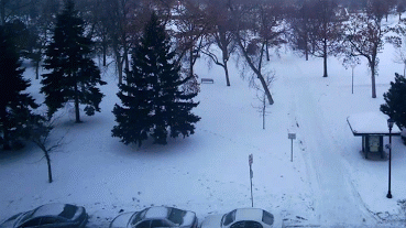
Thinking Warm
We
all have our own unique coping skills, ways of weathering a super-sized
Minnesota winter. I have no desire to buy a boat, but I'll be at the
Boat Show this weekend, gawking at photos of summer fun.
Lately I've
been watching the Golf Channel, just to see the color green. Browsing
warm weather rentals at vrbo.com. I miss whining about the heat &
humidity.
Models suggest 2 more weeks of cold, followed by moderation the latter half of February.
We've
already picked up nearly an hour of daylight since December 21. A
higher sun angle will take the edge off the coldest jabs of Canadian air
within a couple of weeks.
To quote Dan Rather: COURAGE.
It's
hard to get a foot of snow from a sloppy, southern storm when winds
aloft are locked from the northwest, howling from the Yukon. What we've
lacked in Gulf moisture we've more than made up for with a parade of
clippers. Thursday's burst of snow was more significant than predicted,
and roads were a mess. Why?
Sand & chemicals aren't nearly as
effective at 15F as 25F. The colder the storm the greater the odds of a
white-knuckle commute shouting at the car in front of you.
That said, I do see a light at the end of our polar tunnel.
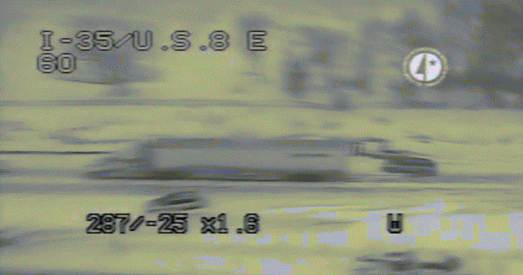 Why We All Need To Slow Down
.
THis is incredible footage, courtesy of MnDOT's traffic camera up in
Forest Lake, focused in on I-35 South. The chain-reaction accident
happened Thursday morning - many drivers unable to slow down in time.
Video clip courtesy of
MnDOT.
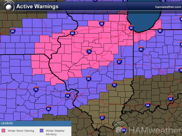
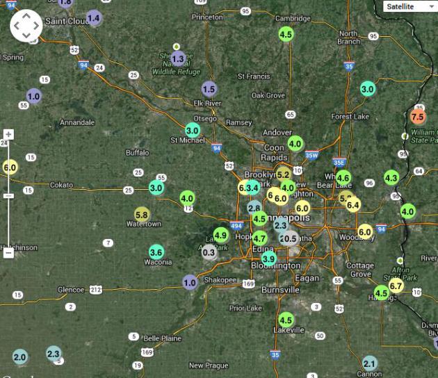
An Especially Fickle Clipper.
1.4" at St. Cloud, 1.5" Elk River, with over 6" at Maple Grove,
Minneapolis and Maplewood, only an inch west of Shakopee. Clippers are
always hard to predict, but yesterday's burst of snow was very tough to
pin down, the stripe of heaviest snow setting up right over the
downtowns. The Twin Cities National Weather Service has an interactive
map with more snowfall amounts
here.
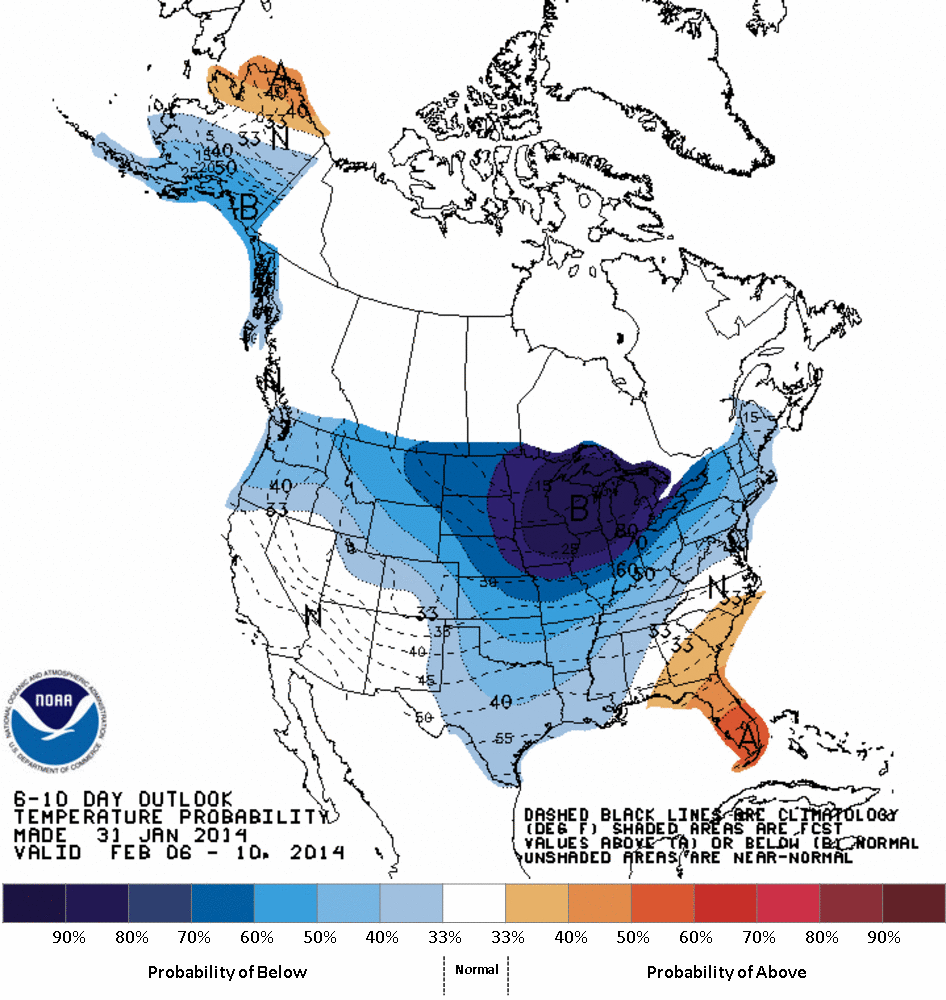
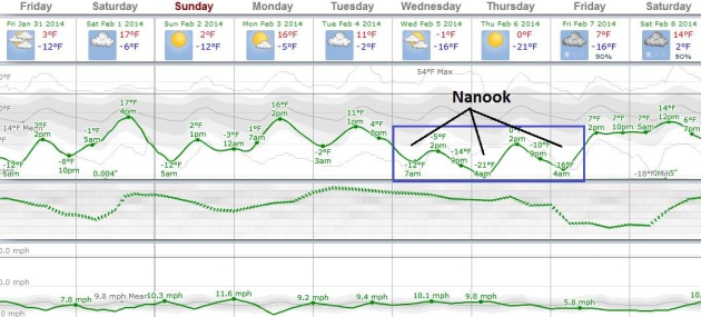
No Relief - Yet.
Highs reach the teens (woo-hoo!) Saturday, again Monday and Tuesday,
before dropping off again the latter half of next week. Another polar
swipe, but not as numbing as last week - probably not school-closing
cold. We've had enough of that. Graph: Weatherspark.
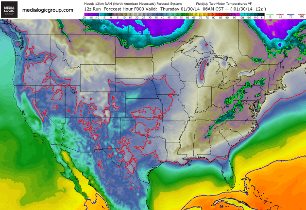
Flirting With Zero.
Although not as cold as last week, temperatures slip below zero the
next couple of mornings across the Upper Mississippi Valley, while the
Deep South thaws into the 50s; 40s pushing as far north as metro New
York City this weekend. 2-meter NAM temperatures: NOAA and Ham Weather.
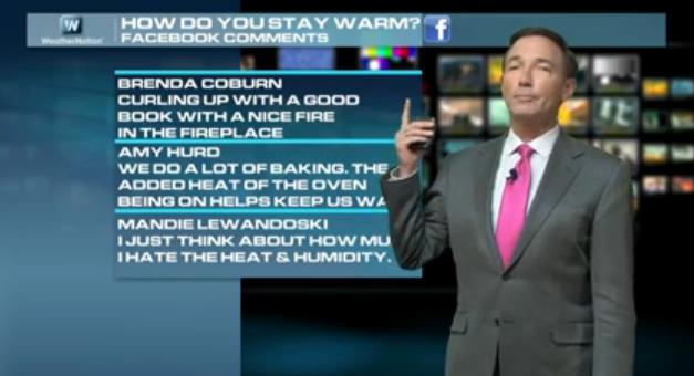 Winter Coping Skills
. In addition to taking a look at the latest Super Bowl weather forecast, today's edition of
Climate Matters
tackles the Midwinter Blues, and how some viewers are keeping a positive
mental attitude, in spite of snow, ice and nagging wind chill. We want
to hear more of your comments and suggestions via Facebook: "
WeatherNationTV
Chief Meteorologist Paul Douglas goes over some of the Facebook
comments shared with us. How do you cope with the cold? Also, what
(climatologically speaking) were some of the most extreme Superbowls?
And the question we are all asking, what is the game time forecast?"
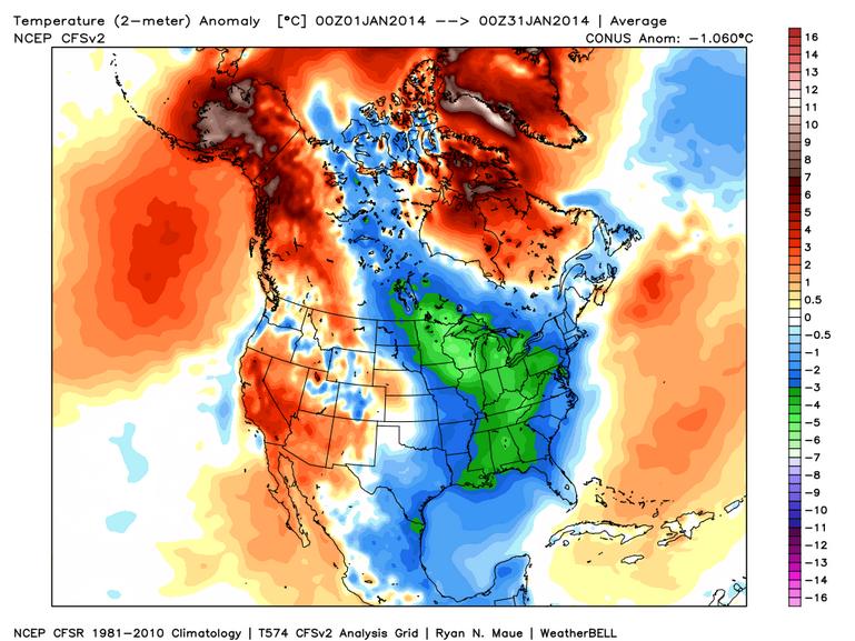
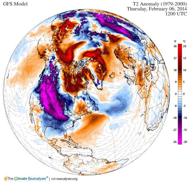
Stuck In A Rut.
Temperature anomalies across the Northern Hemisphere next Thursday
continue to show an "upside-down" pattern, temperatures well above
average from northern Canada into the Arctic, Greenland and Scandanavia,
with a lingering stain of the Polar Vortex from southern Canada into
the central USA. No significant moderation until the third week of
February. Climate Reanalyzer graphic courtesy of the University of
Maine.
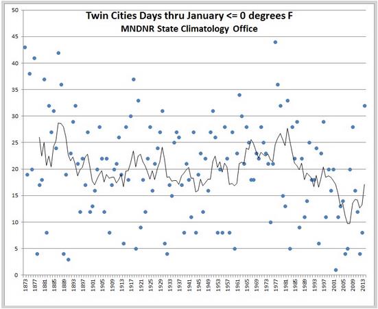
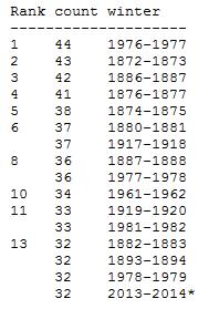
Minimum Temperatures Of Zero Or Colder In The Twin Cities. Pete Boulay, from the
Minnesota Climatology Working Group, passed this nugget along to me - the most subzero lows since December 1 since 1982. Here's an excerpt of the post: "
The
Twin Cities will most likely have the mercury dip to zero or colder 32
times this winter by January 31, the most though January 31 since the
winter of 1981-82. How does the winter of 2013-14 stack up for counts of
minimum temperatures at or below zero in the Twin Cities? As of January
28th there have been 30 minimum temperatures of zero or colder: 13 in
December, and 17 so far in January. Including the forecast for the rest
of the month it looks like January will wind up with 19 minimum
temperatures of zero or colder for a total of 32 so far for the season.
This is the most number of minimums below zero so early in a winter
since the winter of 81-82 when the total through January 31 was 33..."
Graphic credit:
Courtesy: Minnesota State Climatology Office. "
Minimum Temperatures of zero or colder in the Twin Cities Through Jan 31."
Number Of Minimum Temperatures Below Zero As Of January 31.
This takes into account data from 144 winters in the Twin Cities, and
forecast (subzero) lows through Friday of this week; a grand total of
32, the most since 1982, according to the
Minnesota Climatology Working Group.
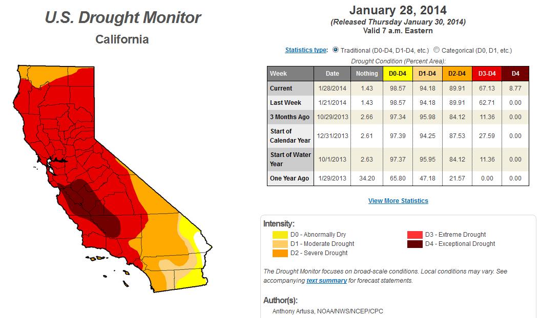
California Drought: Communities At Risk Of Running Dry. The
San Francisco Chronicle has the details - here's a clip: "
It
is a bleak roadmap of the deepening crisis brought on by one of
California's worst droughts - a list of 17 communities and water
districts that within 100 days could run dry of the state's most
precious commodity. The threatened towns and districts, identified this
week by state health officials, are mostly small and in rural areas.
They get their water in a variety of ways, from reservoirs to wells to
rivers. But, in all cases, a largely rainless winter has left their
supplies near empty..."
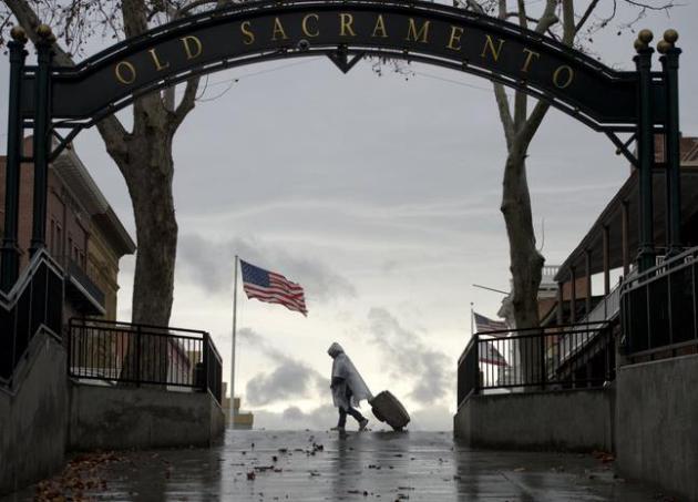
Photo credit above: "
A
pedestrian walks near the underpass that connects Old Sacramento with
Downtown Sacramento during the first day of rain in 52 days on
Wednesday, Jan. 29, 2014 in Sacramento, Calif. The National Oceanic and
Atmospheric Administration's Web site is predicting a tenth of an inch
of rain in San Francisco over the next two days and more than 2 inches
in parts of Sacramento." (AP Photo/The Sacramento Bee, Hector Amezcua).
Drought Forces California Farmers To Cut Back On Planting. You can listen to the story from
NPR.
Mea Culpa.
Every storm is different, and it doesn't take much of a jog in a
storm's track or intensity to throw the forecast off-track. The snow and
ice came in 4-7 hours earlier than predicted, which contributed to the
problem. I have a lot of respect for meteorologist James Spann, in
Birmingham. He doesn't try to spin the truth - he tells it like it is,
and when he's wrong, he owns up to it. He is the exception to the rule.
Here's a snippet from al.com: "Birmingham
meteorologist James Spann, who was called just about every name in the
book as an unexpected snow shut down most of Central Alabama, has
apologized for what he called his worst "forecast bust" since the winter
storm of 1982. Here's what the Spann wrote on his ABC 33/40 weather
blog today:
"In terms of human impact, yesterday's
forecast 'bust' was the most significant for me since January 1982, when
we had a timing error of about six hours on the arrival of freezing
rain and snow..."
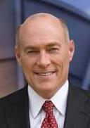
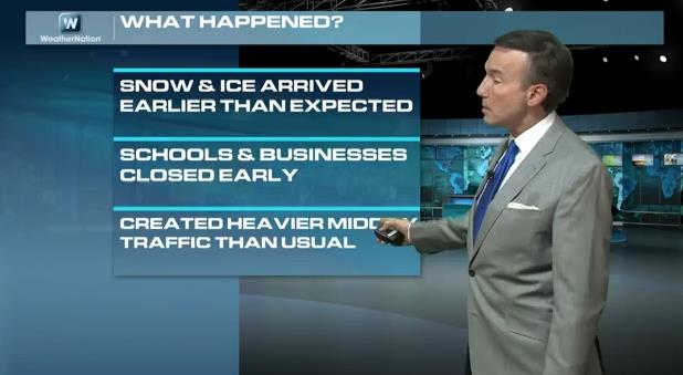
What Really Happened in Atlanta? My Take. Based on what I know of the storm, predictings, onset and impact, I recorded a
segment
for WeatherNation TV explaining why 2" of snow, coming at precisely the
wrong time and temperature, coupled with decisions to close school
early and send many office workers home prematurely, created a cascade
of unintended consequences. That, and how traditional (chemical) snow
removal and spinning tires can turn snow into a sheet of glaze ice: "
WeatherNationTV
Chief Meteorologist Paul Douglas goes over just what went wrong in the
historic snow and ice storm that blanketed the Southeast. Cars were
abandoned, people slept in grocery stores, kids were stuck on buses, and
a 16 hour commute home. What what wrong?"
Super Bowl Weather Climatology.
Rutgers University has a terrific site devoted to Super Bowl Weather,
not only the forecast, but climatology - what has happened on Ground Hog
Day in years gone by, focused on Newark, the closest regularly
reporting weather station in the area. Check out the latest at
biggameweather.com.
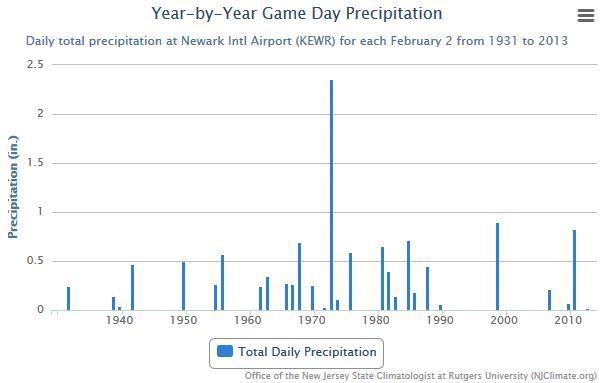
Good Odds. Here is one of the graphics at
biggameweather.com
that caught my eye, February 2 precipitation at Neward since 1931. The
70s and 80s were much wetter (and snowier), with fewer storms since
1990, at least on February 2. I still don't see any blizzards of
mega-storms. What can go wrong?
Would Snow Be A Good Thing At The Super Bowl. Call me crazy, but I suspect the short answer is "no".
The Washington Post takes a look with a video forecast from Capital Weather Gang; here's an excerpt: "
The Post Sports Live crew debates whether it’s good or bad that a cold-weather city is hosting the Super Bowl. The Capital Weather Gang’s latest forecast
seems to indicate that dry weather is likely. The best thought I’ve
heard on it was that snow during the game would be scenic and fun, but
snow leading up to it could cause a real mess..."
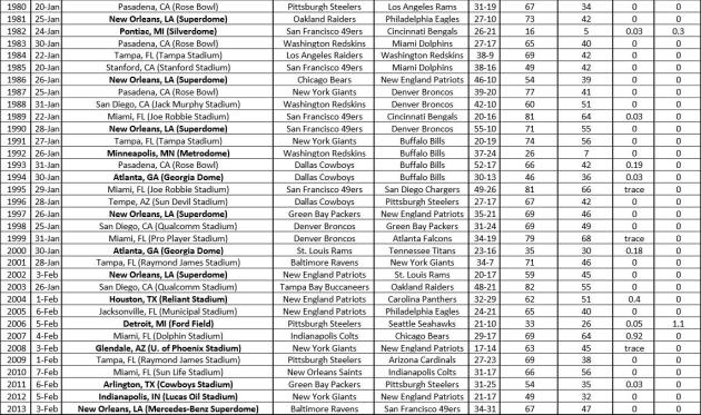
Super Bowl Weather Conditions Since 1967. I thought
this document
(PDF) from NOAA was interesting, highlighting the coldest, warmest,
snowiest and wettest Super Bowls. Sunday's game may go down as the
coldest (for a game played without a dome).
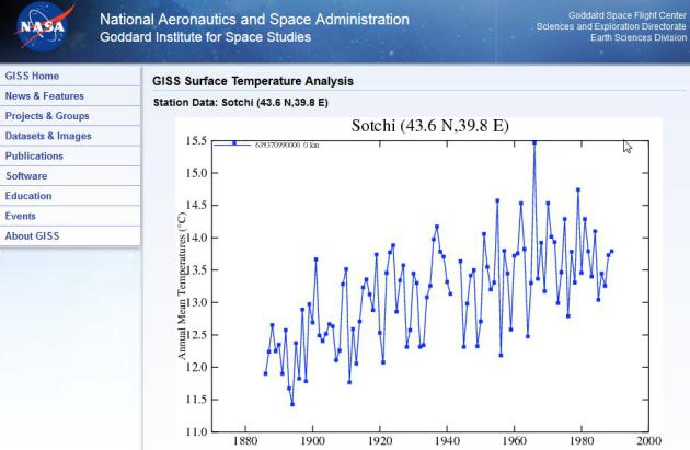
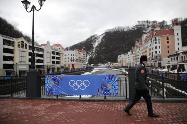
Sochi Temperature Trends Since 1900.
NASA has an interesting graph showing mean annual temperature trends for the city about to host the Winter Olympics.
Melting Snow. The forecast from
Weather Underground
shows highs within a few degrees of 50F almost every day next week at
Sochi, nighttime temperatures staying above freezing (in the city). It's
a good thing they saved/stockpiled snow from last winter. Smart move.
Photo credit above: "
A
Russian Cossack walks across the bridge, Thursday, Jan. 30, 2014, in
Krasnaya Polyana outside the Black Sea resort of Sochi, Russia, where
the snow and sliding sports venues for the 2014 Winter Olympics are
located." (AP Photo/Jae C. Hong).
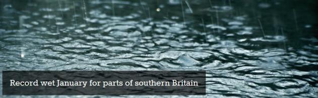
Record Wet January For Parts Of Southern Britain. Here's an excerpt of a summary from the
UK Met Office: "
Early
Met Office statistics for January 2014 show that the southeast and
central southern England region has already had its wettest January in
records going back to 1910, with three days still to go. A large area of
southern England from East Devon to Kent and inland across parts of the
midlands has already seen twice the average rainfall for the month..."
Talking About The Weather: The Next Level. The Atlantic provides some good resources for weather nerds (um, enthusiasts) to track the weather on their own; here's an excerpt: "...
The data keeps going. NOAA can give you surface temperatures from 9,000 weather stations,
some of which have data stretching back to the beginning of the 1900s.
In certain local areas, like San Francisco, people have made this history easier to access. Perhaps the coolest of these projects is @datapointed's look at rainfall patterns in the Bay before and after Valentine's Day. Or if you prefer a more visual interface, Forecast.io brings you Quicksilver..."
Oil Boom: See A Modern-Day Gold Rush In Motion. Yes, what's happening in North Dakota is awe-inspiring.
NPR takes a look - here's a clip: "
If
you've seen any coverage of North Dakota's oil boom, you've seen the
images — oil rigs, truck traffic, "man camps," miles of temporary
housing. But there is something about this place that just can't be
captured by a still photograph. It's a feeling you get when you cruise
down an endless highway under a vast, big sky — until suddenly: BOOM.
You're wedged between semitrucks dwarfing what was once a quiet farm
town..."
Image credit: "
Ritter Brothers, a jewelry and gift store in Williston, N.D., sells miniature oil rigs and other oil-related novelties." (Annie Flanagan for NPR)
The 2013 NFL Season In 160 Seconds. Because you're in a hurry. Check out the video clip from ESPN and
kottke.org: "
If
you haven't been watching the NFL at all this season but are planning
on tuning into the Super Bowl, this video by ESPN will prepare you by
recapping the entire season in under three minutes..."
If You Can't Wait For Super Bowl Ads.
The Wire has a run-down on many of the spots, some of which are already online; here's a clip: "
You
have wait until Sunday to see the Super Bowl, and as usual, you won't
have to wait that long to see the famous commericals. Many of the big
advertisers will be unveiling their commercials online during the week,
to build buzz and get a little extra mileage out of their very
expensive, celebrity-studded production. Others prefer to keep you in
suspense. Here is a collection of the ads that have been released so
far, but keep checking back as we'll update this post as the week goes
on and new ones arrive..." (Image credit: YouTube and Budweiser). Why am I thirsty all of a sudden?
*
thanks to Ham Weather uber-developer Lee Huffman, who used Google Glass
to capture the video clip above when it was -24F. No, it's not a
gadget, it's a productivity tool. At least that's what I tell my wife. I
need one of those...
Climate Stories....
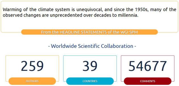
Climate Change 2013: The Physical Science Basis. AR5 WG1 results are now available from
IPCC: "
The
Twelfth Session of Working Group I (WGI-12) was held from 23 to 26
September 2013 in Stockholm, Sweden. At the Session, the Summary for
Policymakers (SPM) of the Working Group I contribution to the IPCC Fifth
Assessment Report (WGI AR5) was approved and the underlying scientific
and technical assessment accepted..."
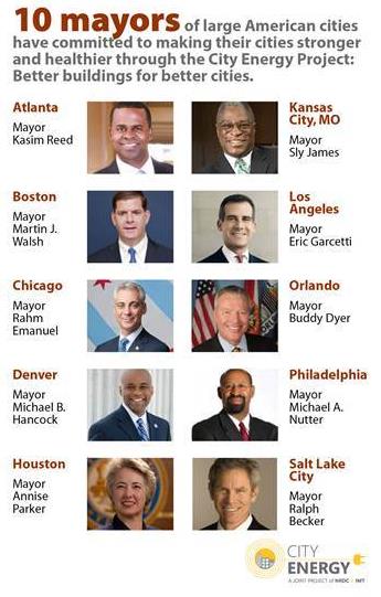
10 American Cities Will Lead The Nation On Energy Efficiency. Here's a clip from a story at
Huffington Post: "...
Making
buildings more efficient presents a major opportunity for cities to
save money, improve air quality, and become more resilient. Many
efficiency measures pay for themselves within three to five years.
That's why 10 mayors of American cities announced today
that they'll be partnering with NRDC and the Institute for Market
Transformation in the new City Energy Project. By working to transform
energy-sucking buildings into energy sippers, these cities will slash
energy use, cut pollution, and save residents and businesses combined $1
billion a year on their bills..."
Climate Change Is Already Causing Mass Human Migration.
Smithsonian.com has the story - here's their introduction: "
There
are a lot of reasons people move: for work, for love, for the draw of
the big city or the quiet of nature. But as the world continues to warm,
it's expected that global climate change will become another factor
driving people to move: to dodge coastal erosion and sea level rise, to
follow changes in rainfall, to avoid strengthening storms. Climate change is already inducing marine animals to migrate, and according to a new study published in the journal Nature Climate Change, it's starting to make people move, too..."
Warming Oceans Consistent With Rising Sea Level & Global Energy Imbalance. Here are some key bullet points of new research, a good summary of which can be found at
Skeptical Science:
- The ocean is quickly accumulating heat
and is doing so at an increased rate at depth during the so-called
“hiatus” – a period over the last 16 years during which average global surface temperatures have risen at a slower rate than previous years.
- This continued accumulation of heat is apparent in ocean temperature observations, as well as reanalysis and modeling experiments, and is now supported by up-to-date assessments of Earth's energy imbalance.
- Another
key piece of evidence is rising global sea level. The expansion of the
oceans (as they warm) has contributed to 35–40% of sea level rise over
the last two decades - providing independent corroboration of the
increase in ocean temperatures.
Foundations Band Together To Get Rid Of Fossil-Fuel Investments. The New York Times reports - here's an excerpt: "
Seventeen
foundations controlling nearly $1.8 billion in investments have united
to commit to pulling their money out of companies that do business in
fossil fuels, the group plans to announce on Thursday. The move is a
victory for a developing divestiture campaign that has found success
largely among small colleges and environmentally conscious cities, but
has not yet won over the wealthiest institutions like Harvard, Brown and Swarthmore..."
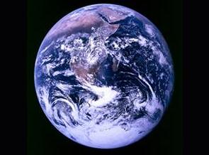
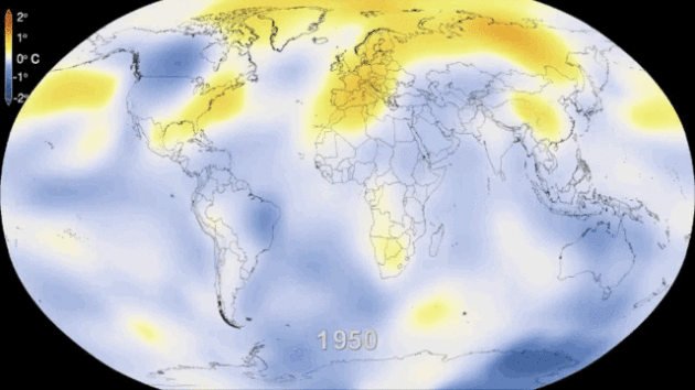
Cosmic Coincidence Or Trend? Seeing is believing, but keeping a global perspective is critical. The timelapse above is from NASA, courtesy of a story at
bgr.com; here's a clip: "...
The
GIF above is a consolidated version of NASA’s full animation that helps
illustrate just how drastic the change has been since 1950.
Temperatures in some regions have swung by as much as 4 degrees Celsius
in the past 60 years alone..."
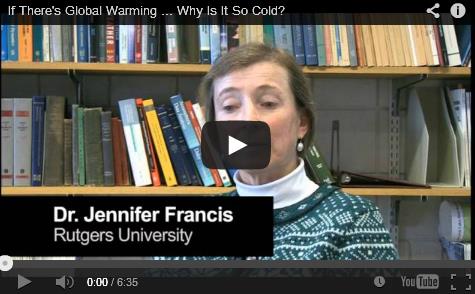
If There's Global Warming, Why Is It So Cold? Peter Sinclair posts a video at
Climate Denial Crock Of The Week
that describes climate volatility, how changes in the Arctic may be
creating more extremes: cold and heat, not to mention droughts and
floods. Here's a link to the video and excerpt: "
I did one of these
years ago, during the “Snowmageddon” events of 2009, and have been
meaning to update. The current situation lends itself perfectly. I
continued the tradition of interviewing Jeff Masters at Dunham Lake,
near his pastoral southeastern Michigan home, and by serendipity, caught
up with Jennifer Francis at the nearby University of Michigan for a
quick update/interview."
Just Because It's Cold Doesn't Mean Global Warming Isn't Real. It Is. Here's an excerpt of an Op-Ed that caught my eye at
pennlive.com: "...
Even
if conservative politicians refuse to concede the evidence for climate
change, insurance companies have already done so. Last year, Peter
Hoeppe, who heads Geo Risks Research at a huge reinsurance firm called
Munich Re, told The New York Times: "Numerous studies assume a rise in
summer drought periods in North America in the future and an increasing
probability of severe cyclones relatively far north along the U.S. East
Coast in the long term. The rise in sea level caused by climate change
will further increase the risk of storm surge..."
The Flip-Side Of The Polar Vortex.
Depending on what channel our media outlet you turn to for weather news
you may be getting only half the story - shocked? Me neither. Here's an
excerpt from
Media Matters: "
Right-wing media are laughing
about President Barack Obama mentioning climate change in his fifth
State of the Union address because it is cold in D.C. But the wobbly polar vortex bringing cold air to much of the contiguous United States is simultaneously causing record warmth in Alaska, a state often seen as the nation's "ground zero" for climate change. On January 28, Alaska's largest newspaper, the Anchorage Daily News,
ran this remarkable headline: "Record warmth, confused plants: An
Alaska January to remember." The article noted that it was 62 degrees in
one town, tying the January state record, but did not allude to the
long-term warming trend..."
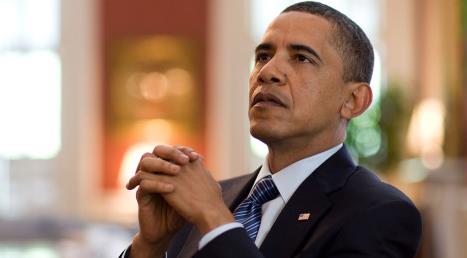
6 Things Obama Can Do On Climate Without Congress.
Grist has the story - here's an excerpt: "...
last week, the Center for the New Energy Economy at Colorado State University released a report, coauthored by former Colorado Gov. Bill Ritter, that details 200 climate actions Obama could take without Congress. So what options does the president have? Here are a few ideas:
1. Continue the crackdown on coal pollution: This month the Environmental Protection Agency released a new draft of rules that would strictly curtail emissions of carbon dioxide from new coal-fired power plants; a second set of rules that would apply to existing plants is expected later this year..."
Photo credit above: The White House.
Jekyll And Hyde: The Two Sides Of Obama's Energy Strategy.
ThinkProgress has the post; here's an excerpt: "...
America’s
contribution to the global problem of ever-rising carbon production and
consumption grows unabated. I applaud Obama’s commitment to EPA
standards on carbon pollution from power plants. But his continued
embrace of “all of the above” energy reflects a true Jekyll and Hyde
split personality. Let’s hope that unlike the progression of the Robert
Louis Stevenson novella, Obama’s “Hyde” side doesn’t take over..."
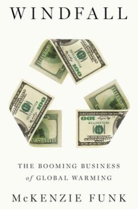
Entrepreneurs Looking For "Windfall' Cash In On Climate Change.
NPR has the audio clip and text; here's a clip: "
In
2008, as scientists documented a record melt in the Arctic ice and Al
Gore's film An Inconvenient Truth was in theaters, a half dozen major
investment houses launched mutual funds designed to take advantage of
financial opportunities offered by climate change. In Windfall: The
Booming Business of Global Warming, journalist McKenzie Funk looks into
how some entrepreneurs and even some nations stand to benefit from a
changing climate..."
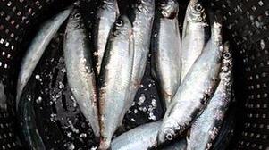
Climate Change "Could Be Making Fish Smaller" Say Aberdeen Researchers. That explains my lake of luck on Pelican Lake.
The BBC reports: "
A
decline in the length of fish in the North Sea could be linked to
climate change, according to researchers at the University of Aberdeen.
Their findings suggest edthe maximum body length of fish including
haddock, whiting, herring, plaice and sole has fallen by as much as 29%
over 38 years. They said that coincides with an increase in water
temperatures of between 1C and 2C. Food availability and fishing
pressure was also assessed..."
Photo credit:
"Researchers looked at fish including North Sea herring."
The Guardian's perspective on the research referenced above is here.


