Tuesday, December 31, 2013

WNTV Blog For AM Wednesday: Continued Cold with an Eastern Snow Storm?

Cold End to 2013
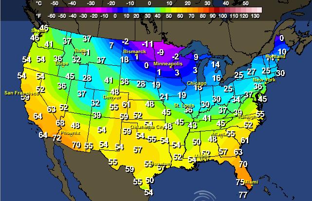
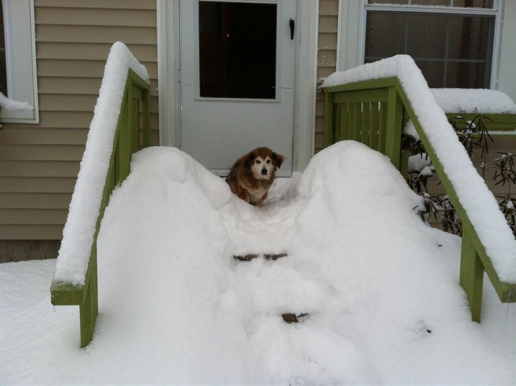
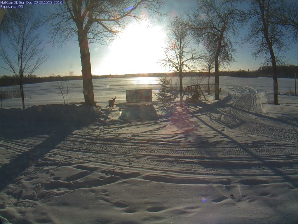
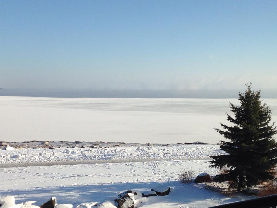
It was definitely a cold end to 2013 for many folks across the northern tier of the nation. Here's a frigid picture from my good friend Amy Betwy out of Duluth, Minnesota. The air temperature earlier Tuesday was -21F with a wind chill of -40F!


Coldest of the Cold
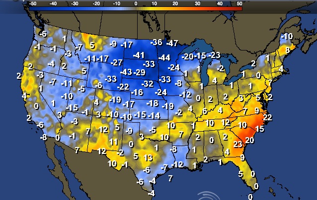
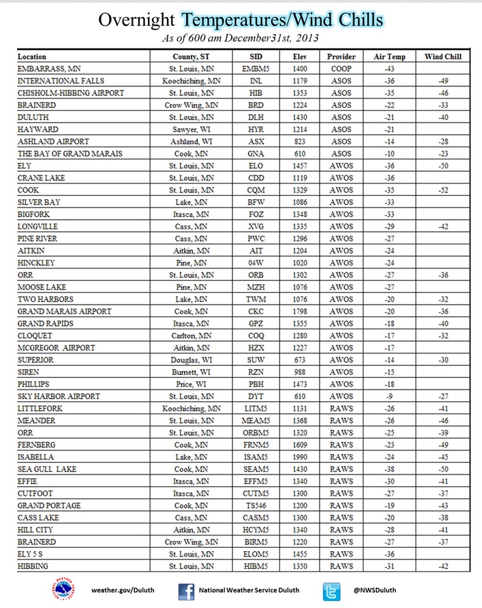
Here are some of the coldest readings (and wind chills) from AM Tuesday (New Year's Eve) from the National Weather Service out of Duluth, MN. Note the -43F low temperature from Embarrass, which was the coldest temperature recorded across the entire Lower 48 on Tuesday!


Cold December in International Falls
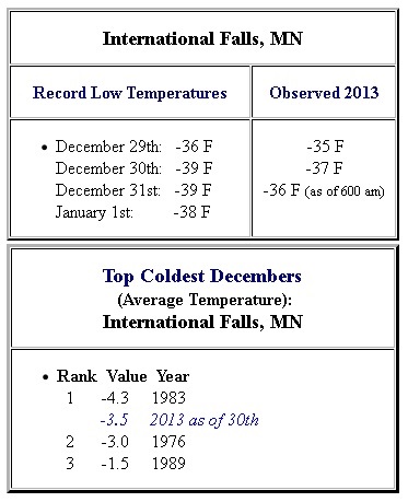
According to the National Weather Service, International Falls had one of it's coldest December's on record! Through the 30th of December it was the 2nd coldest!


More Cold on the Way...
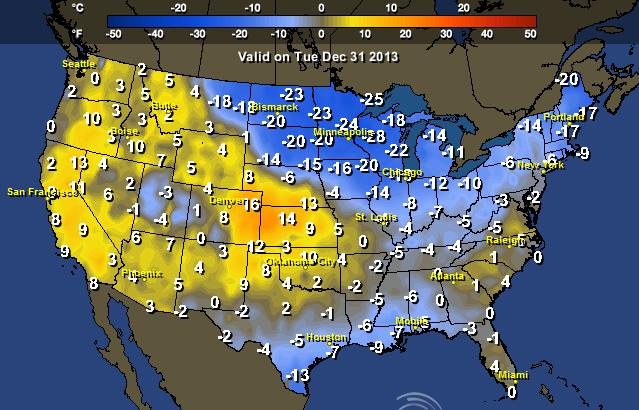
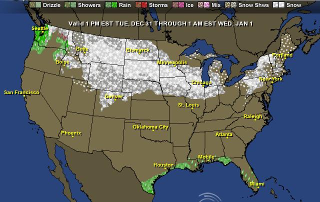
I hate to say it, but it appears that the cold air could stick around through mid January. Note the brief warm up later this week across the Midwest prior to another (potentially even colder blast) by next week.

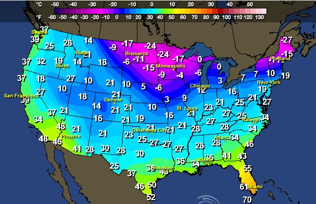
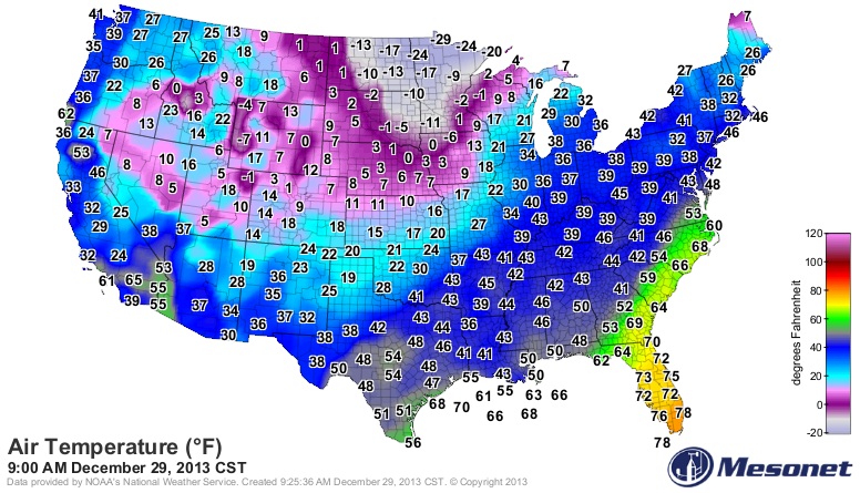
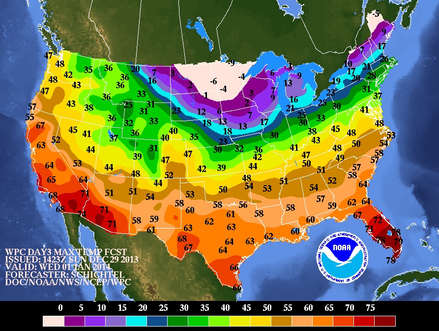
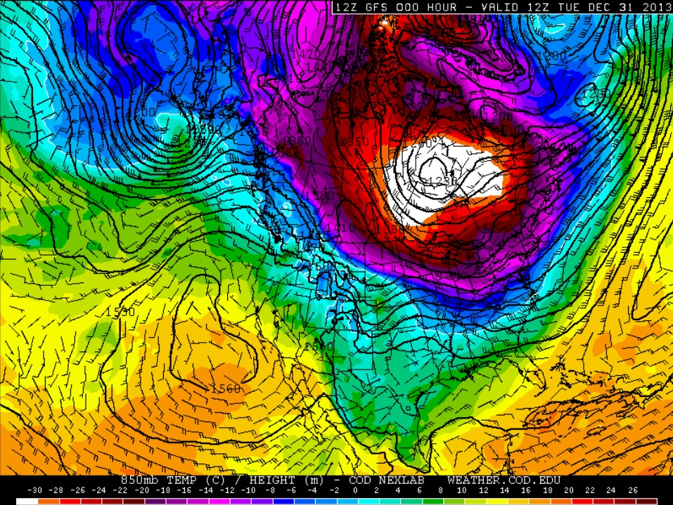
New Year's Eve Temps
On Tuesday morning the core of the coldest air was situated near the Hudson Bay.
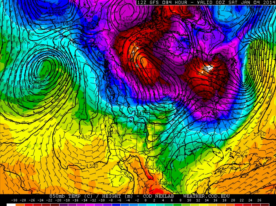


Friday, January 3rd
By late this week, the core of the coldest air looks to be situated over parts of the Northeast with another lobe developing across northern Canada.
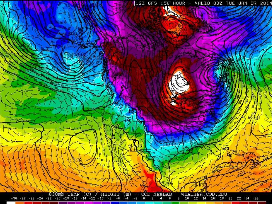


Monday, January 6th
Latest forecasts still point to a very frigid start to the work week next week as that secondary lobe of Arctic air brushes the Upper Mississippi Valley/Great Lakes Region. If the current forecast holds, this surge of Arctic air will be felt across a more widespread area in the eastern half of the nation.


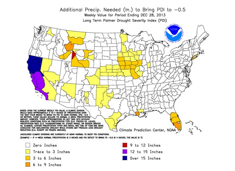
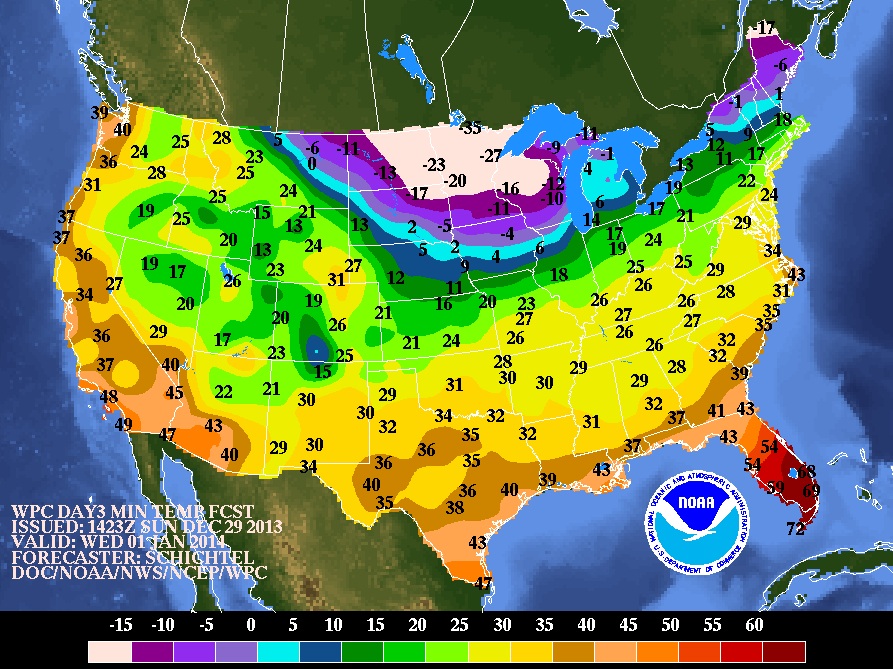
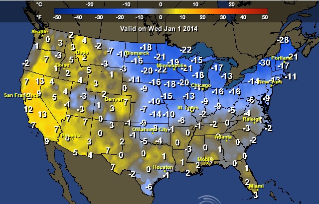
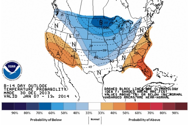
Temperature Outlook Thru Mid January
According to NOAA's Climate Prediction Center, there's a good chance that below normal conditions will continue right throught the middle of the month. It's probably not what some folks want to hear after such a cold December, but January is typically the coldest month of the year.


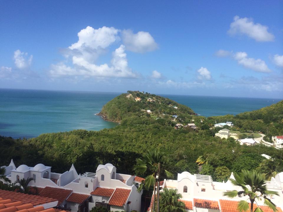
Think Warm Thoughts!
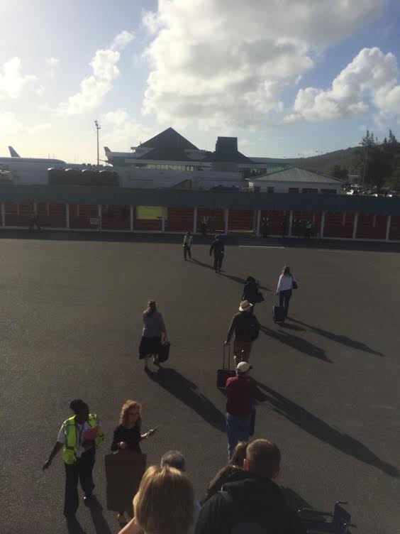
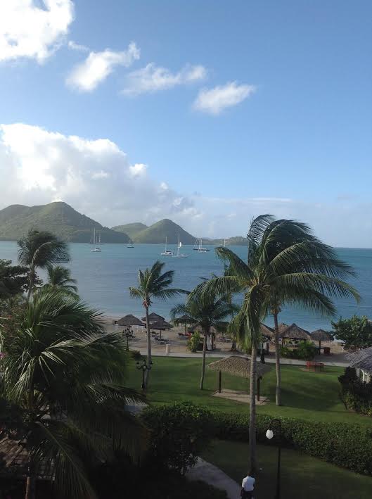
Thanks to my good friend Meghan Gehrke for this teaser... At this point she's probably trying to rub it in! Looks fantastic in the eastern Caribbean on the Island of St. Lucia.


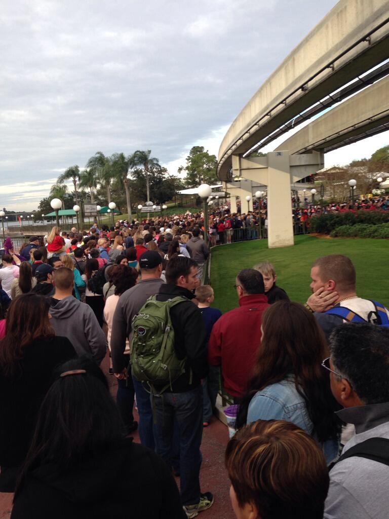
Big Lines at Disney World
It's a nice thing that temperature were rather warm on Tuesday afternoon at Disney World. Take a look at these lines for folks waiting to get into the park for the New Year's Eve festivities. Apparently the wait time was nearly 2 to 4 hours!

(picture courtesy: @scarlettashley1)


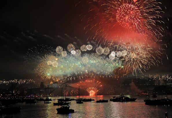
Ringing in the New Year
Happy New Year! Here's was a brilliant shot from Sydney Australia as they rang in the New Year Down Under.

(photo courtesy: @Coral)


Top 10 Most Popular New Year's Resolutions
Here's an article from Fool.com, which shows the most popular New Year's Resolutions according to a study done by Harris. I bet you can guess the # 1 resolution...

"# 10: Set aside time for yourself
Last, but certainly not least, is the 10th most common New Year's resolution that states American's desire to get more "me time." Like No. 9 above, I can whole-heartedly agree with this one as "me time" is an important key to relaxation.


Perhaps nothing says relaxation like online travel service provider Priceline.com (Nasdaq: PCLN), which allows consumers to combine their flight, hotels, and car reservations into a discounted package. With most Americans unwilling to give up their vacation regardless of their economic situation, and Priceline pushing dominantly into Europe, it's a smart "me time" play."

Read more HERE:


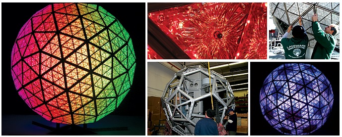
NYC Times Square Ball Fun Facts
Have you ever wondered what goes into the infamous ball in Times Square? Here's this year's fun facts from:

TimesSquareNYC.org

Ball Fun Facts
The Ball is a geodesic sphere, 12 feet in diameter, and weighs 11,875 pounds.

The Ball is covered with a total of 2,688 Waterford Crystal triangles that vary in size, and range in length from 4 ¾ inches to 5 ¾ inches per side.

For Times Square 2014, all 2,688 of the Waterford Crystal triangles introduce the new design Gift of Imagination - featuring a series of intricate wedge cuts that appear to be endless mirrored reflections of each other inspiring our imagination with a kaleidoscope of colorful patterns on the Ball.

The 2,688 Waterford Crystal triangles are bolted to 672 LED modules which are attached to the aluminum frame of the Ball.

The Ball is illuminated by 32,256 Philips Luxeon Rebel LEDs (light emitting diodes). Each LED module contains 48 Philips Luxeon Rebel LEDs - 12 red, 12 blue, 12 green, and 12 white for a total of 8,064 of each color.

The Ball is capable of creating a palette of more than 16 million vibrant colors and billions of patterns producing a spectacular kaleidoscope effect atop One Times Square.


Walleye Drop?
Now this is a little more up my alley! It's the annual "Walleye Drop" in Port Clinton, OH where the "Madness at Midnight" is host to several folks along the shores of Lake Erie. This festive event is host to a 20foot, 600lbs walleye named Wylie.

Read more about Wylie HERE:

(photo courtesy: 13abc WTVG)
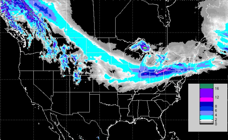


Tracking Lows
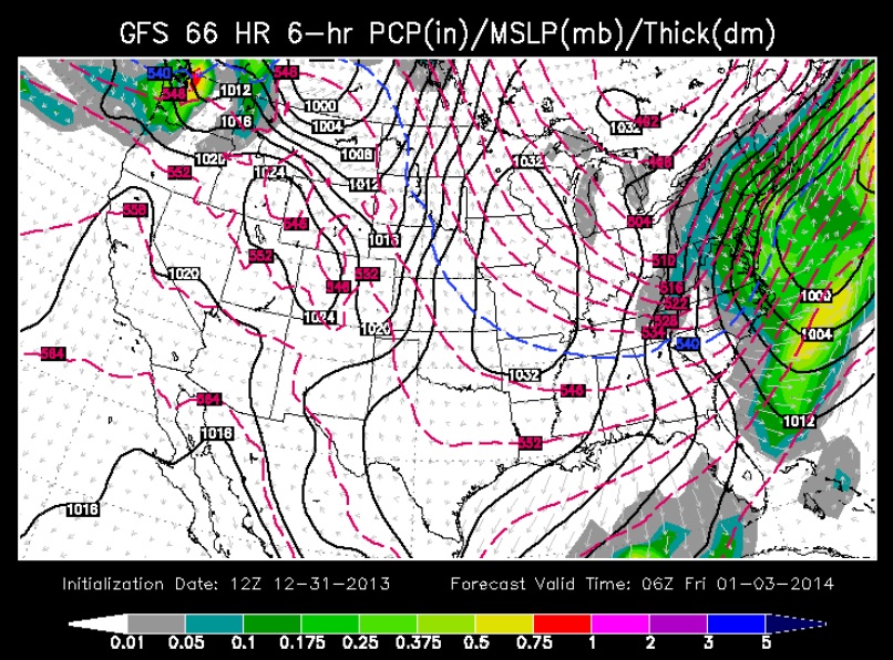
The storm will begin to take shape later this week as two areas of low pressure begin to merge Thursday. By Friday morning, one area of low pressure looks to emerge as it races up the Northeast coastline.
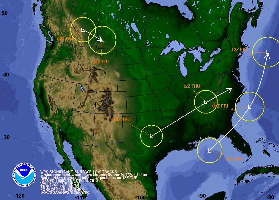


Strong Low Pressure
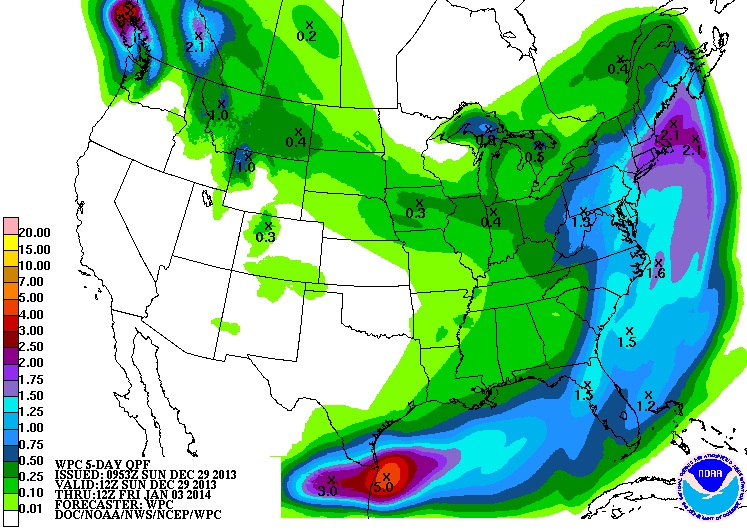
The merged area of low pressure looks fairly impressive by late Thursday night/AM Friday as it pulls away from from the Eastern Seaboard. With this setup, there should be cold enough air for decent/shovelable snow tallies across a wide area.


Heavy Snow Potential
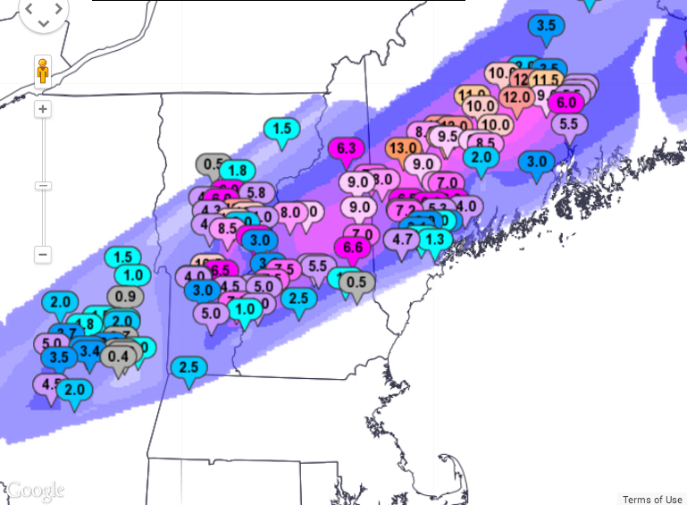
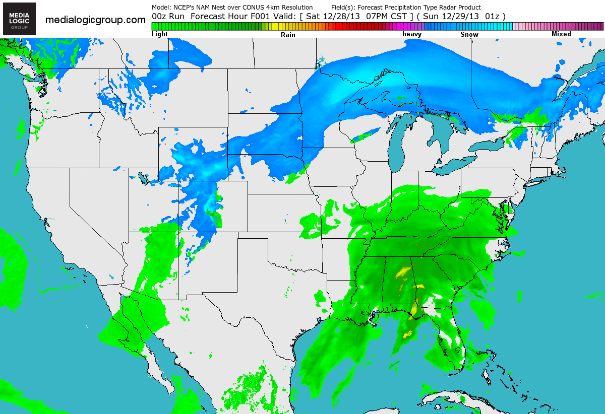
The next thing on the docket is the heavy snow potential late week from the Great Lakes to the Northeast. At this point, plowable snow looks inevitable for many across a large area over the next few days.


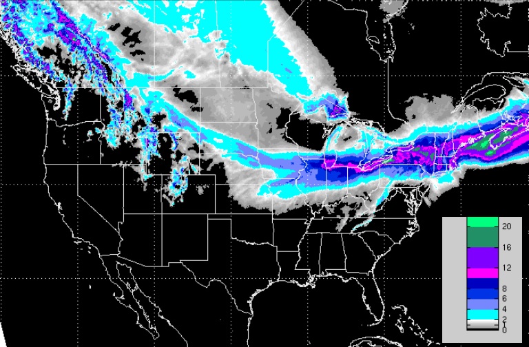
The snow looks quite a bit more pronounced in the Northeast later this week as two areas of low pressure look to merge near the Northeastern coast.


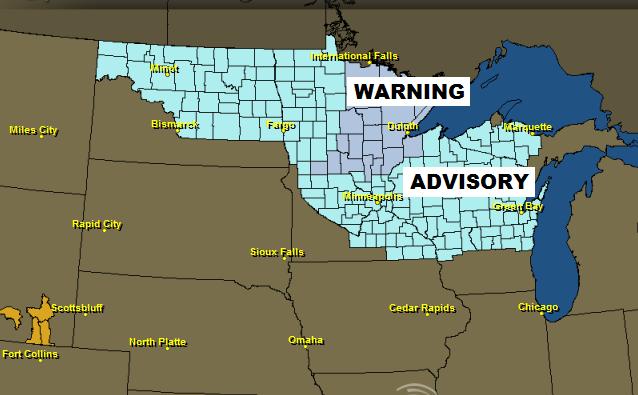
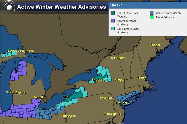
Winter Weather Headlines
The National Weather Service is already issuing winter weather headlines for some of the major cities in the Northeast. Keep an eye on latest forecasts as this storm has the potential to impact travel greatly later this week.


Thanks for checking in and have a great rest of your week!
Don't forget to check me out on Twitter @TNelsonWNTV

Monday, December 30, 2013

WNTV Blog for AM Tuesday: The New Year Approaches

On The Edge
By Todd Nelson

Tick tock, tick tock... Why do I always feel like the world is going to flip upside down when the clock strikes midnight on New Year's Eve? Maybe I still have a bad taste in my mouth from the much hyped "Y2K Bug" 14 years ago. Other than being cold, I'm hoping there are no glitches as we turn the page to a new year Tuesday Night.

Thru the end of December, we'll have seen 11 sub-zero nights, all of which have occurred in December! January is typically the coldest month of the year with 10 sub-zero nights; December typically sees around 6. According to NOAA's NOWData, the Twin Cities has around 24 sub-zero nights during the entire winter season; the threat of sub-zero nights generally fades by early March.

Extreme cold is helping to shove the storm track just south of the Twin Cities Metro. Another fast moving clipper system will dive through the High Plains towards Chicago during the day Tuesday and bring a plowable snow chance to Chicago by New Year's Day!

I am happy to report that teens are in the forecast by the end of the week, that'll feel nice. Don't get used to it though as another cold blast looks to arrive early next week. UGH! -Todd Nelson
____________________________________________________________________________

MONDAY NIGHT: Light snow tapers early. Gradual clearing and cold again!. Low: -13. Feels Like: -25F Wind: WNW 5.

NEW YEAR'S EVE DAY: Clouds thicken, light snow possible in extreme southern MN (generally alon I-90). High: -1. Feels Like: -25F. Winds: N 5-10

NEW YEAR'S EVE NIGHT: Chance of a few flurries in southern MN, still very cold. Low: -10. Feels like -25F

NEW YEAR'S DAY: Cold! A few flakes to ring in 2014?. High: 1. Feels Like: -20F

THURSDAY: Increasing sun, still quite cold.Wake-up: -10. High: 0

FRIDAY: Warmer! Increasing clouds, light snow possible over night. Wake-up: -12. High: 11.

SATURDAY: Lingering AM snow. Breezy. Wake-up: 8. High: 18.

SUNDAY: Light snow, turning colder again. Wake-up: 1. High: 10.

MONDAY: Harsh wind returns. Wake-up: -12. High: -2.
______________________________________________________________________________

This Day in Weather History

December 31st

1999: Balmy end to the 2nd millennium over Minnesota with temperatures in the 30's over central and southern Minnesota near midnight.

1937: Damage done by flood at Grand Marais. 18 inches of snow dumped on Grand Portage.

1913: New Ulm had its fortieth consecutive day without precipitation.
______________________________________________________________________________

Wind Chill Concerns
Surprise, surprise. Wind chill concerns continue across parts of the Midwest, where temperatures seem to be their coldest.

...VERY COLD WIND CHILLS EXPECTED THROUGH TUESDAY MORNING...

A REINFORCING BLAST OF ARCTIC AIR WILL SPREAD ACROSS THE REGION TONIGHT THROUGH TUESDAY. NORTHWEST WINDS COMBINED WITH CONTINUED COLD TEMPERATURES WILL PRODUCE WIND CHILL VALUES OF 20 BELOW ZERO TO 40 BELOW ZERO AT TIMES. THE COLDEST AIR WILL BE FOUND NORTH OF A LINE FROM ALEXANDRIA TO MORA...WHERE A WIND CHILL WARNING IS IN EFFECT. SOUTH OF THAT LINE...A WIND CHILL ADVISORY IS IN EFFECT.


Forecast Highs Tuesday
High temperatures across the Upper Midwest will once again struggle to get above zero for some locations.


U.S. Highs From Normal Tuesday
It's pretty impressive to see high temperatures nearly 25F below average across the Upper Mississippi Valley, but not that far away, we see high temperature forecasts nearly 15F above average!


New Year's Eve Night
If you have plans to ring in the New Year across the northern tier of the nation, make sure you bundle up. Take a look at the cold temps expected by AM Wednesday!


New Year's Eve Forecast
For all the folks heading out and about on New Year's Eve, here's a look at the weather forecast across the country.


Hot Dog?
Thanks to my good friend Michelle Surgeson for this interesting picture out of La Quinta, CA where temperatures have been consistently reaching the upper 70s to lower 80s across much of southern California. At first glance, you would think that this pooch is trying to keep warm by the fire, but in fact, the fire is not lit and is laying on the cooler patio blocks! Looks like a "ruff" life!


Cold Cat
On the contrary, this cat is laying on a heat vent trying to keep warm. Thanks to my good friend, Matt Dux for this picture out of Kansas City, where Zeus is hogging all the heat!


A Pooch on the Porch
Might as well stay on the animal train... Thanks to @MMilliken47 for this pooch on the porch picture from snowy Belgrade, ME. Snow reports of a foot or more came in after a quick hitting snow storm blew through on Sunday.


Northeast Sunday Snow Map
Here are some of the snow totals from that particular snow event across the northern New England States.


More on the Maine Power Outages
Here's more on the power outages across parts of Maine from the BostonHerald.com

"PORTLAND, Maine — Another snowstorm has knocked out power for more Maine homes and businesses as a stormy December featuring more than 2 feet of snow and a prolonged ice storm draws to a close.
The National Weather Service says the latest snowstorm Sunday night brought the snow total to 26.2 inches in Portland. That's more than double the snowfall in the typical December.
Central Maine Power says about 5,500 customers lost electricity in the latest storm. Bangor Hydro Electric, which is still dealing hundreds of outages from last week's ice storm, says about 1,600 homes and businesses are now in the dark.
Meterologist Mike Cempa says the new year could start the way the old one ended, with another snowstorm. He says a costal storm is on tap for Thursday and Friday."

(Photo Courtesty: Shirley Spong Lynn from Downeast Region, ME)


More Snow on the Way
Here's the snow potential through AM Thursday. Note the narrow band of potentiall heavier snow from the High Plains to the Great Lakes to the Northeast during this time. Areas near the Great Lakes Region could see some of the heaviest tallies around New Year's Day (Wednesday) and Thursday.


3 Day Precipitation Outlook
According to NOAA's 3 day precipitation outlook, there will be more precipitation across the southern tier of the nation in the form of rain. Some of this could be heavy, especially across southern Texas, where there has already been some heavier tallies over last few days.


A Wet December (for some)
December has been a fairly soggy month, especially across the Southeastern U.S. and the higher elevations of the Pacific Northwest.

Precipitation Past 14 Days


Precipitation Past 30 Days


U.S. Drought
Here's an interesting look at the Drought from this year to last. Note how much more widespread the drought was in the 2012 across the Plains than it is today. However, note how the drought has become much worse across in the western part of the country, espeically in California.


How Much Rain Are We Talkin' Here?
According to the Palmer Drought Severity Index:

"The Palmer Drought Severity Index (PDSI) (known operationally as the Palmer Drought Index (PDI)) attempts to measure the duration and intensity of the long-term drought-inducing circulation patterns. Long-term drought is cumulative, so the intensity of drought during the current month is dependent on the current weather patterns plus the cumulative patterns of previous months. Since weather patterns can change almost literally overnight from a long-term drought pattern to a long-term wet pattern, the PDSI (PDI) can respond fairly rapidly."

This is how much additional precipitation is needed bring the (PDI) to -0.5. This shows that parts of California need a foot of liquid precipitation or more!!


Thanks for checking in and have a great rest of your week ahead!
Don't forget to follow me on Twitter @TNelsonWNTV

Sunday, December 29, 2013

WNTV Blog for AM Monday: Colder with Clippers

Thinking Warm Thoughts!
After the recent blast of Arctic air, I think we all need a little reminder that warm air still exists somewhere around the globe!

Here's a nice warm view from my good friend Megan Gehrke who arrived in St. Lucia in the eastern Caribbean this weekend!


Here's another one from the warm tropical beaches, where another one of my good friends Jennie Moren also has the right idea!


And one more from the National Weather Service out of Miami, Florida on Sunday morning. What a stunning sunrise!


Back to Reality
Some of the coldest air across the entire nation was located across the Upper Midwest on Sunday morning, where air temperatures dipped into the -10s and -20s (nearing -30F across the far north). Here's a shot from Pimushe Resort located in central/northern Minnesota (near Bemidji) where temperatures dropped to the -20s and wind chills values neared -40F on Sunday morning!


Here's another cold shot from my aunt Marsha, who braved the cold early Sunday morning for this sunrise photo near Crosby, MN! BTW, she said she also heard the rumble Friday night from the Midwest meteorite I mentioned in Sunday's weather blog... pretty cool!


BIG Change!
This is an amazing map, which shows the power of the front. Note the near 50F swing from Saturday to Sunday.


Sunday Morning Temperatures
Here's the national temperature map from Sunday morning. Note that there are near -30F temperature readings across the far north! YIKES!!


Sunday Morning Wind Chills
When you factor in the wind, it felt MUCH colder...


Wind Chill Concerns
Dangerous wind chills will be in place through early this week as bitter cold continues to lodge itself into the Lower 48. Wind chill values could be as low as the -40s across the far north!


It is important to keep in mind that if you plan on spending ANY time outdoors, dress appropriately! With temperatures as cold as they are/will be, frost bite can occur within a matter of minutes!


Cold Into the New Year
As we ring in the new year, the cold air is here to stay. If you have plans for New Year's Eve, here are the expected low temperatures by AM Wednesday, which look mighty cold across the far north.


Forecast Highs Wednesday (New Year's Day)
Here are the chilly high temperatures forecast for New Year's Day on Wednesday, which will still be sub-zero across the far north and into the northern New England States.


Highs From Normal New Year's Day (Wednesday)
High temperatures from normal and Wednesday (New Year's Day) will still be well below the norm across much of the eastern two-thirds of the nation.


U.S. Snow Cover 2013
According to NOAA's NOHRSC, nearly 31% of the nation is covered in snow.


Interestingly, by this time last year there was nearly double the amount of U.S. snow coverage (64%).


Early Week Forecast
We say goodbye to a very soggy weekend across the eastern third of the nation, but colder air and more precipitation will continue into the early week ahead. Clipper systems with light snow accumulations will dive in from Canada, while continued rain chances will continue across the deep south from southern Texas to the Mid-Atlantic Region.


This Week's Precipitation Forecast
The upcoming week ahead looks soggy once again for folks from southern Texas to the Mid-Atlantic region. The southern tier of the nation will be warm enough for rain, but the precipitation across the northern tier of the nation will be cold enough for some snow accumulations


Somewhat Snowy Outlook
Looking ahead through early next week, clipper systems will help to freshen up the snow cover from the High Plains to the Great Lakes and the Northeast. Notice the narrow band of snow cover these clipper system will provide over the coming days.


More Wintry Weather
Interestingly, some of the heavier snow (thru Monday) will be found across parts of Maine, where some folks are still without power after the major ice storm blew through places from Michigan to Maine nearly 1.5 weeks ago!
Here's a story from the HuffingtonPost.com:

"Michigan bore the brunt of the storm as nearly 600,000 homes and businesses lost power, and as of Friday afternoon, about 60,000 customers remained in the dark. Maine reported almost 12,000 outages and in eastern Canada, nearly 62,000 still hadn't had their power restored, including 33,000 in Toronto."


(photo courtesy: @lisa51966 from Litchefield, ME)


Thanks for checking in and have a great week ahead!
Don't forget to follow me on Twitter @TNelsonWNTV