Spring Arrives Wednesday
Say what? I know, I can't believe it
either... especially now that we have a fresh coating of snow across the
region. The 'official' number from the MSP Airport was a little over 3"
by late afternoon Monday. Some of the heavier tallies were across the
far north.
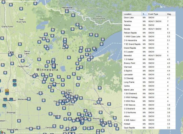
Here are some of the heaviest snowfall reports I could find across Minnesota (as of 5pm Monday).
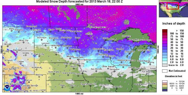
Snowpack - March 18th, 2013
According to NOAA's NOHRSC, there is still quite a bit of snow on the ground across the region. The midday Monday update from the Minneapolis/St. Paul, MN Airport had a snow depth of 9" and the Grand Forks, ND area had 14" on the ground.
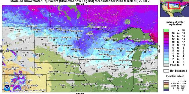
SWE?
What's that? SWE is considered to be "Snow Water Equivalent" which tells us how much 'water' is locked up in the snow. It's a good tool for hydrologists when forecasting during the spring flooding season. According to NOAA's NOHRSC, the modeled shallow SWE suggests that there is still several inches of 'water' locked in the snow acrss parts of the Red River Valley and northern Minnesota. That means that if any 8" core of that snowpack were to be melted down there would be the corresponding amount of liquid water in the legend. To me (guessing) it looks like for any 8" core that would be sampled across northern MN, you could get nearly 5" to 8" of water... Now, could you imagine if hundreds of thousands of acres of that snow were to melt rapidly? That would be a tremedous amount of water and that's what we don't want to happen this Spring!
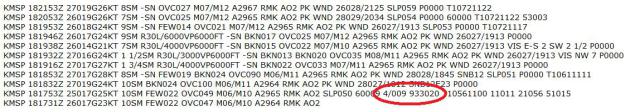
Minneapolis SWE
Every midday Monday during the winter season when there's 2" of snow on the ground, a snow core is down to determine how water equivalent there is in the snow. The 18z METAR observation on March 18th revealed that there was 9" of snow on the ground (4/009) with that snow equating to 2" water equivalent (933020).
Regular Spring Flood Outlooks to Continue
The National Weather Service in the Twin Cities will continue their regular Spring Flooding outlooks until further notice. The next update is on March 21st... Here's the March 7th update:
With the snowfall in February, conditions have changed from below normal with the January outlooks to a Normal Risk of Flooding with the February Outlooks for locations including
Montevideo on the Minnesota River
Granite Falls on the Minnesota River
Redwood Falls o the Redwood River
New Ulm on the cottonwood River
Long Prairie on the Long Prairie River
St Cloud on the Sauk River
St Cloud in the Mississippi River
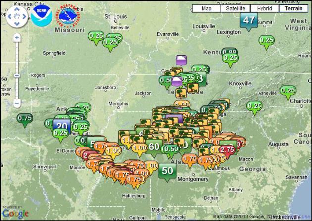
While severe to extreme drought conditions still exist still across the region, precipitation from December 2012 through the first part of March has been near normal to even above normal in some areas. Hence some regions do have a decent snow pack with water equivalents of 3 to 5 inches. The graphic below shows the amount of water in the snow pack on March 6, 2013.
Read More HERE:
The image below shows the streamflow analysis from Monday... all the red/orange dots indicate low streamflows, while the blue/black indicate high streamflows due to recent heavy rainfall in addtion to any snowmelt.
See the Streamflow map HERE:

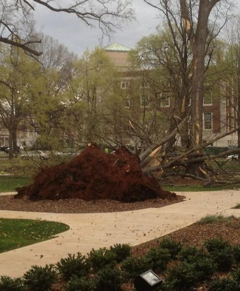
Stormy Monday
Thanks to @hbryant0722 for the picture below from the UA Campus in Tuscaloosa, AL. Strong thunderstorms rumbled across parts of the Southeast with lots of damage being reported on Monday
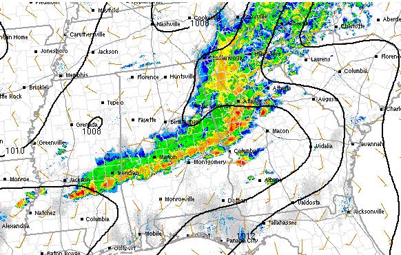
Intense Thunderstorms
Monday was a BIG severe weather day for folks in the Southeast. This is a look at the line of thunderstorms from Monday early evening as they were rumbling across the area.
Storm Reports - Good Bookmark
Here's a good bookmark for you. This is a great interactive website to find information on individual storm reports. You can literally zoom down to street level!
See more from the National Weather Service out of San Diego HERE:
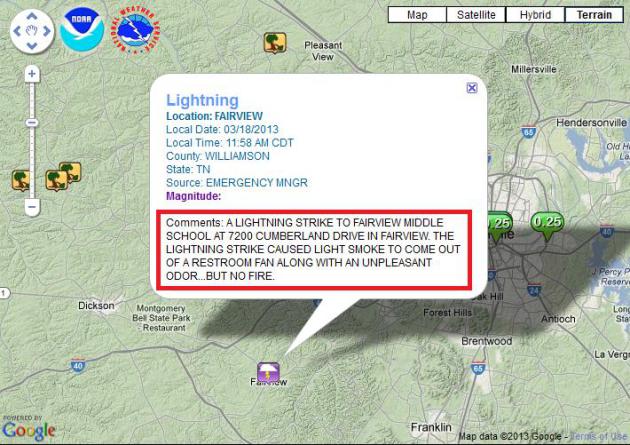
Interesting Storm Report
I happened to stumble across this report yesterday from TN caused by a lightning strike. Good news that nobody was hurt! I'll just let you read the comment...
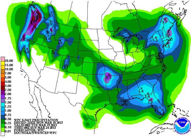
National Precipitation Outlook
NOAA's HPC 5 day precipitaiton outlook (forecast from 7pm Monday to 7pm Saturday) looks rather interesting...
Note the big blob of moisture over the Northeast and another surge of
Pacific moisture that rides in from the Northwest and drops into the
Southern Plains. Parts of the Northeast will see heavy snow potentail
through Tuesday, while the storm from the Northwest to the Southern
Plains will have a mixture of rain/snow along its path.
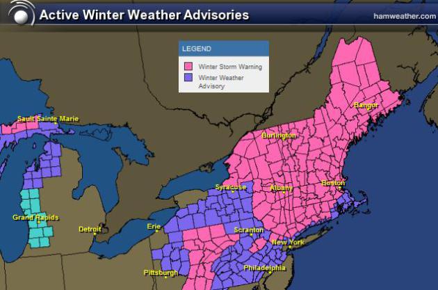
Northeast Snow Potential
The National Weather Service has issued winter weather headlines for much of the Northeast thru AM Wednesday. Some spots could see 12"+ especially in the higher elevations of the Northern New England States.
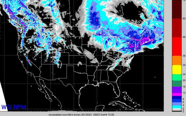
National Snowfall Forecast
This
is the 3 day snowfall forecast from the 18Z RPM from midday Monday -
Midday Thursday. It shows the heavy snow potential across the Northeast
through AM Wednesday and the next blob of moisture heading into the Northwest with mountain snow.
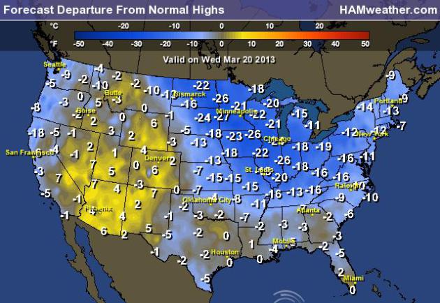
Spring Arrives Wednesday
By
the way, Spring arrives Wednesday at 6:02am CDT. That's when the sun's
most direct rays will shine over the Equator. This is also the date at
which a number of locations across the globe will see nearly equal day
and night! Here's a look at how much above or below we'll be in the high
temperature department on the Vernal Equinox (Wednesday). Note how much
of the nation will be cooler than average and by quite a margin!
Thanks for checking in, have a good rest of your week!
Don't forget to follow me on Twitter @TNelsonWNTV