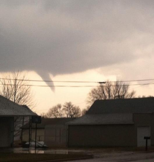
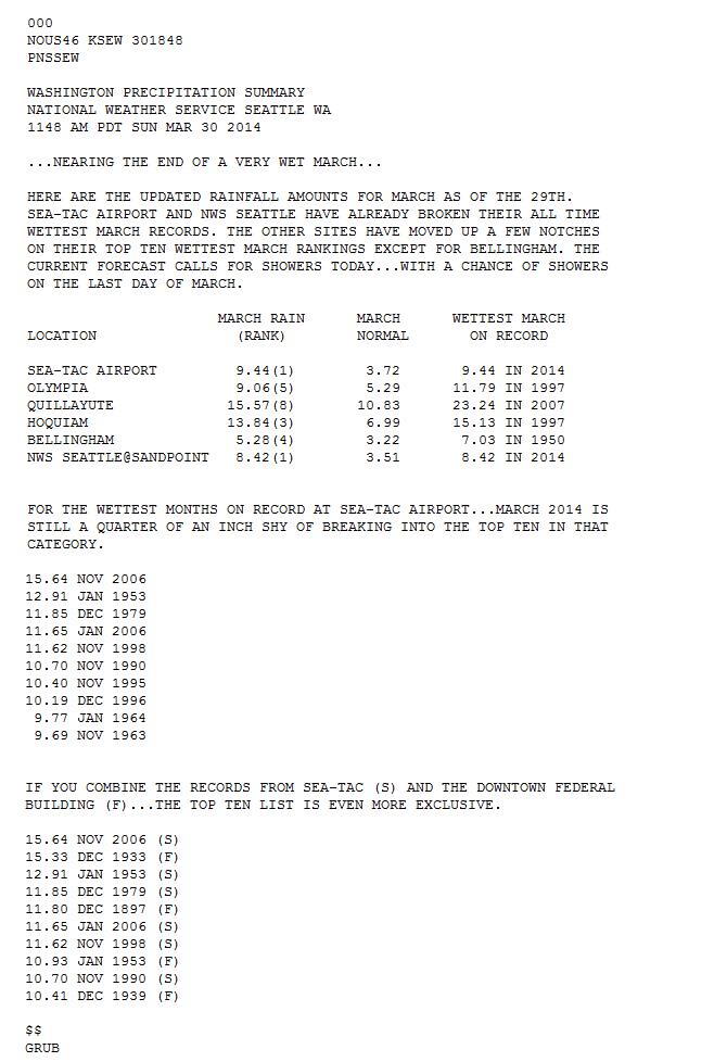
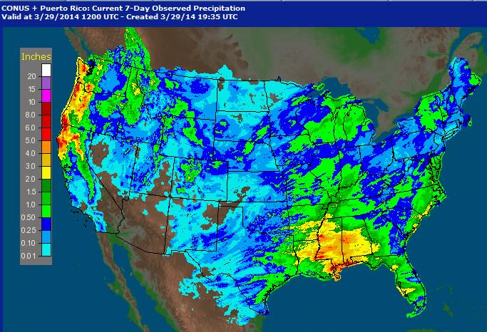
Blizz-nado?
I'd
like to lock Mother Nature in my basement and throw away the key. March
came in like a polar bear and went out like a (rabid) mountain lion,
with blizzard conditions over the Red River Valley yesterday, but that
wasn't the most unusual feature of yesterday's weather map.
In 40
years of tracking the weather I have NEVER seen a tornado warning and a
blizzard warning in effect (simultaneously) for the same county. That
happened yesterday in Yellow Medicine county; tornadoes moving at 40 mph
causing structural damage near Saint Leo - the county under a blizzard
warning for high winds and snow expected to move in Monday night. A new
level of weather-whiplash. A new level of bizarre.
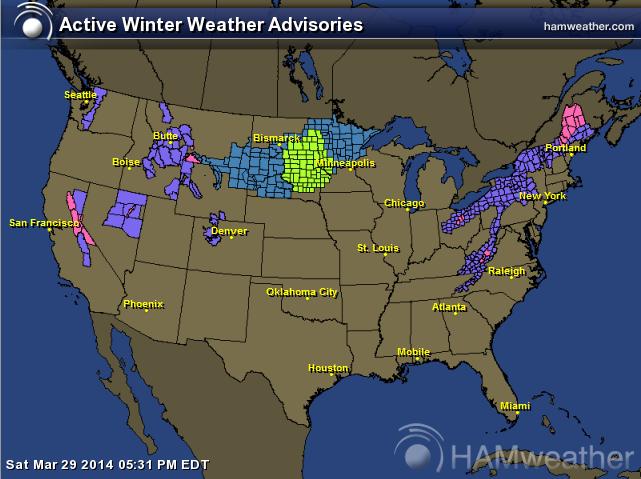
Whispers of the
Polar Vortex return today as cold exhaust shakes the trees outside your
window - a coating of slush possible in the metro; a few inches of snow
for Brainerd. But we all realize that spring in Minnesota is always two
steps forward, one step back.
A clumsy atmospheric waltz.
No
more 60s in sight anytime soon, in fact heavy jackets linger into late
week with a few days in the 30s and low 40s. It's premature to toss
around inches, but there may be enough cold air in place for a slushy
snow event by Friday. But even if it does snow a high sun angle
guarantees rapid melting, with 40s returning next week, even a shot at
50F.
If anyone asks the average high reaches 65F in the Twin
Cities by the end of April. Extended models show a cool bias. We won't
be boating anytime soon.
Longer term an El Nino is brewing; warmer
Pacific water which often correlates with milder winters here. That's
more of a prayer than a forecast by the way. But we go from one extreme
to the next.
Maybe we'll catch a break.
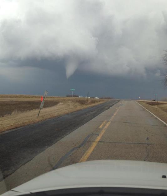
* photo of tornado near Minneota Monday afternoon courtesy of Ronni Vlaminck and KARE-11.
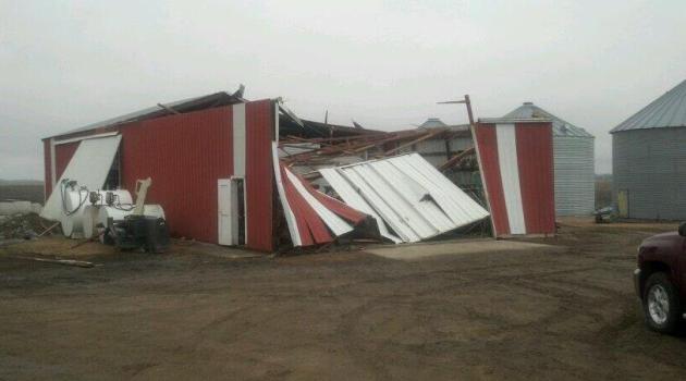
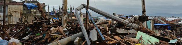
Minor Structural Damage.
Abraham Grant snapped this photo near Saint Leo, showing EF-0 damage to
outbuildings - no reports of injuries from yesterday's freakish
tornadoes in Yellow Medicine County.
* NOAA SPC confiirmed 3 tornadoes as of late last night.
Details here.
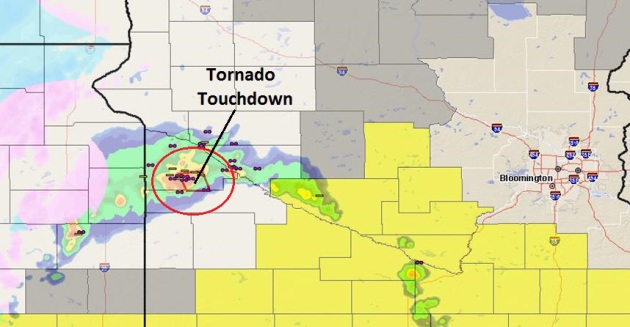
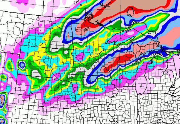
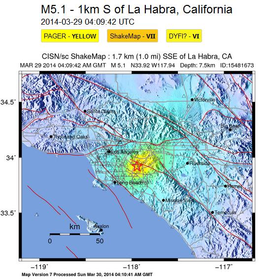
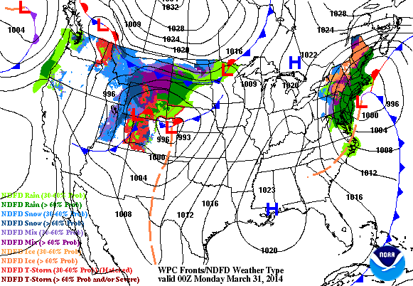
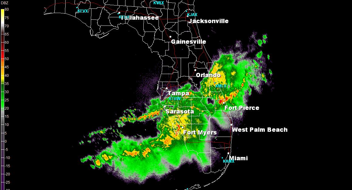
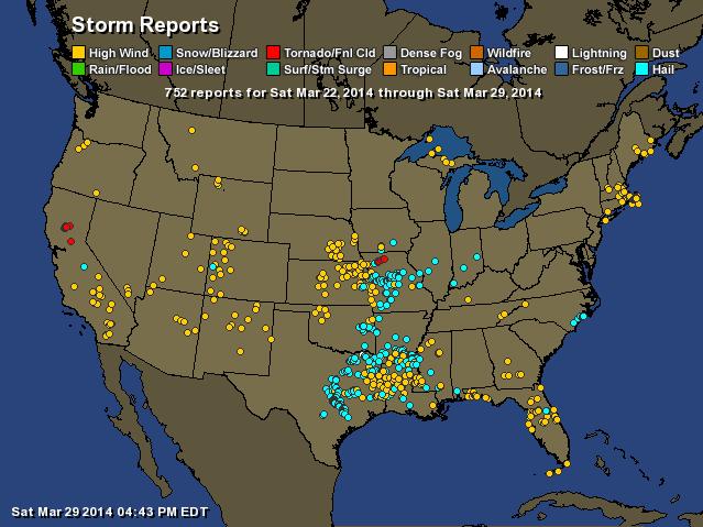
Taking Weather Whiplash to a New Extreme.
Tornado warnings issued for a county under a Blizzard Warning? True,
blizzard conditions weren't expected until Monday night, and convection
whipped up in the "dry slot", a surge of warm, dry air that pushed into
southwest Minnesota, resulting in highs in the 70s, a sharp temperature
gradient and subsequent low-level wind shear that spun up a couple of
small tornadoes. (Map: Earth Networks).
"
Hey Paul, I have a
question. Have you ever seen a confirmed tornado (Warning) in the same
place where a Blizzard Warning is also in effect? Hard to believe my
eyes right now. Then again in Wisconsin yesterday there was elevated
fire danger in the same areas where rivers were flooding. What could
possibly be ahead??? Cue the locust."
Kent Smith
Eden Prairie
Short answer? No.
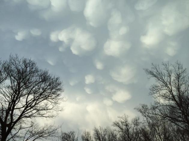
Who's Your Mamma?
Sorry - I've been standing too close to the Doppler. No locust showing
up (yet), but Mike Gaddow in Prior Lake captured a great shot of
cumulonimbus mammatus clouds as thunderrshowers pushed across the metro
Monday evening, "pouches" of rain and hail illuminated by the setting
sun.
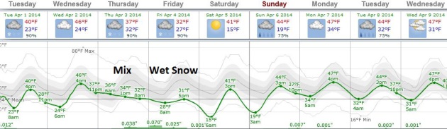
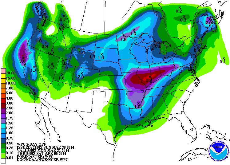
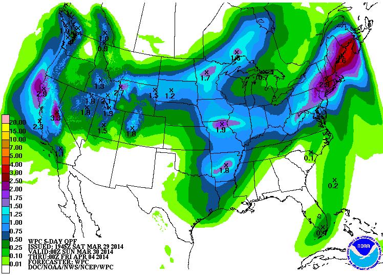
Spring Is In No Great Hurry.
This probably won't come as much of a surprise, but there's every
indication we'll limp into spring this year. The southern USA is warming
up nicely, but a series of cold intrusions sweeping out of Canada will
result in a sharp north-south temperature gradient capable of whipping
up a series of storms: rain and snow. The best chance of precipitation
comes Thursday into Friday, possibly a rain/snow mix ending as a few
inches of slushy snow Friday. Graphic: Weatherspark.
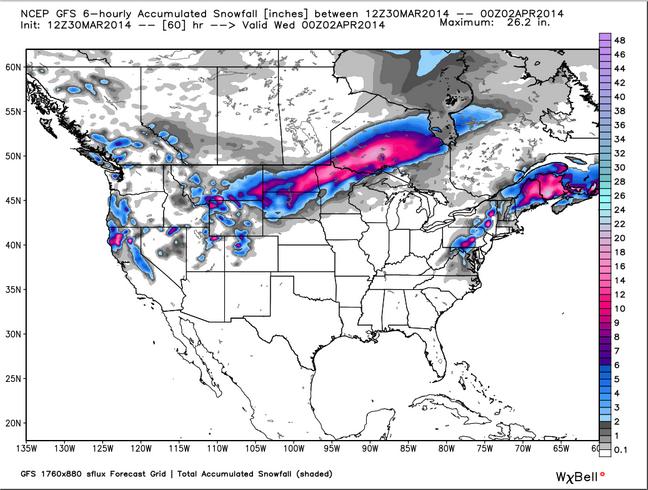
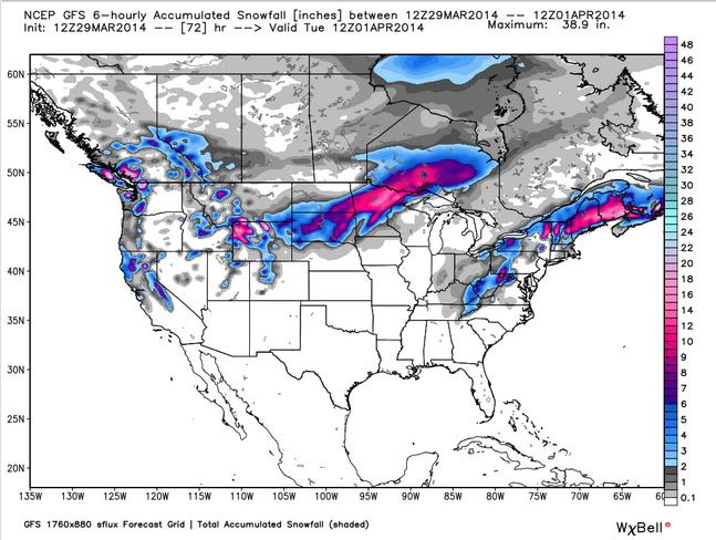
Too Early To Panic (Much).
Again, I tend to go with "persistence", which is a fancy way of saying
go with the flow, don't deviate from the current pattern and trends.
Spring is taking it's sweet time, with only a few tantalizing glimpses
of real warmth. I'm not buying a major snowfall for Friday (yet) - I
want to see a few more computer models and see if the solutions are
consistent. But there's certainly a potential for a "few inches" of
slushy snow Thursday night into late Friday. GFS data shows the best
chance of a hearty pile of snow south/east of the Twin Cities. Too early
to say with confidence, but we'll keep an eye on it. Feeling lucky?
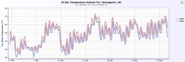
A Reason To Keep On Going.
After showing the GFS model solution it would be cruel and unusual not
to leave you with a few ragged scraps of hope. Here it is, courtesy of
NOAA's CFS (Climate Forecast System) model, showing highs consistently
in the 60s or milder after about April 23. My confidence level is low in
anything that far out, but let's pretend this might actually happen.
Graphic:
Ham Weather.
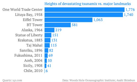
A 1,720 Foot High Tsunami?
I thought it was a typo at first, but apparently not. Good grief. I'm
feeling better about being near the center of the North American
continent. Here's an excerpt from an eye-opening account at
Quartz: "...
Calamity struck
at 10pm on July 9, 1958, when a 8.0-Richter-scale earthquake rammed the
Alaskan coast up and northward. That impact shook free between 40
million and 60 million cubic yards (30.6 million and 46 million cubic
meters) of rock and ice that rimmed the Lituya basin, dumping it 3,000
feet into the bay below. The 1,720-foot monster that
reared up as a result shot through the bay at 100 miles per hour (161
kilometers per hour), as Susan Casey details in her book, The Wave: In Pursuit of the Rogues, Freaks and Giants of the Ocean..."
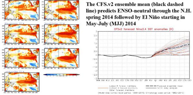
Higher Probability Of El Nino By Summer of 2014.
The threshold is .5C, and we should reach that in the Pacific as early
as May or June. For a little light reading and more than you ever wanted
to know about a brewing El Nino and ENSO in general, check out this 29
page PDF from
NOAA NCEP.
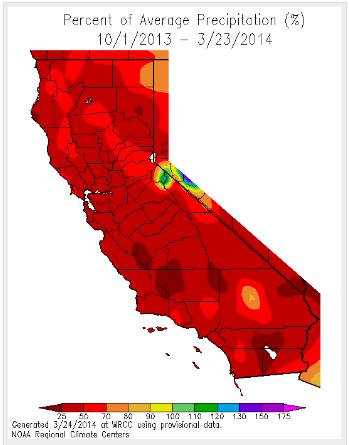
Update On California Drought.
Residents of the western USA may be praying for a moderate to severe El
Nino warming phase of Pacific Ocean water, which correlates with more
frequent storms for California and a more active southern branch of the
jet stream. Here's a good summary of the deepening drought from Peter
Gleick at
scienceblogs.com.
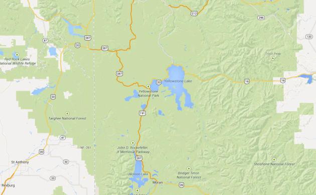
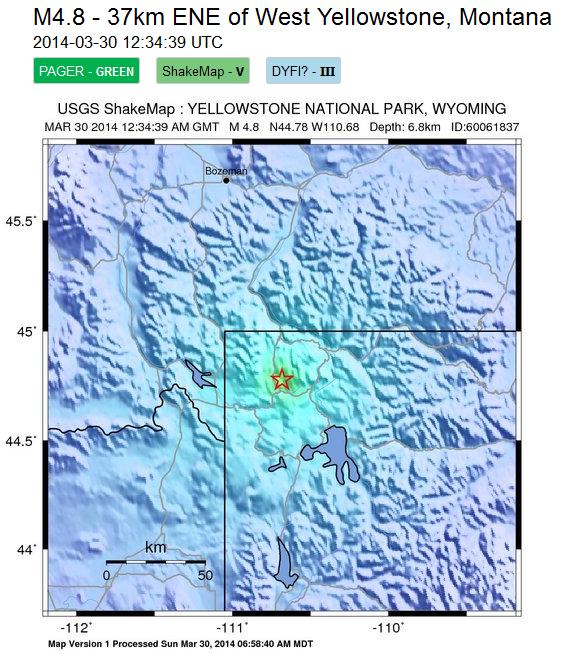
4.8 Magnitude Quake Hits Yellowstone. The tremor was reported on Sunday in an area riddled with earthquake faults - more details from
earthsky.org. (Map: Google).
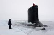
Parallel Parking In The Arctic Circle. If you missed Thomas Friedman's latest Op-Ed in
The New York Times it's definitely worth a read - with a son in the Navy I found this especially fascinating. Here's an excerpt: "...
More
important, you learn how crucial acoustics are when operating deep
under ice with no vision and no GPS satellite to guide you. Or, as the
New Mexico’s captain, Todd Moore, 40, put it: It’s like every day
“engaging in a knife fight in a dark room: the only thing you can do is
go after what you hear.” You can’t see the adversary. You can’t see the
ice keels, but you can hear enemy subs, surface ships, whales, calving
icebergs, schools of fish and bounce sound waves off them with sonar to
measure distances..."
Photo credit above: "
The U.S.S. New Mexico broke through the ice 150 miles north of the North Slope of Alaska to pick up some passengers." Credit Joshua Davies Communication Specialist 2nd Class/U.S. Navy Photo.
People Can Predict The IQ Of Men, But Not Women, By Looking At Their Face. Deep down you always knew this, right? Here's an excerpt from
psypost.org: "
New research published in PLoS One
has found that a man’s facial characteristics contain some clues about
his intelligence. Surprisingly, the same can’t be said for women’s
facial traits. And the particular male facial characteristics linked
with intelligence are a mystery..."
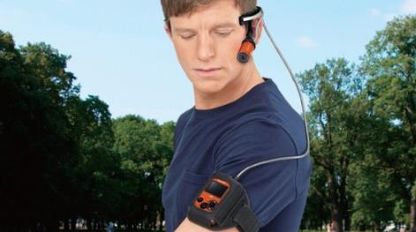
How You Know If You're A Serious Techno-Geek. At least this new wearable camcorder doesn't look too dorky. Details from
Gizmag: "
Panasonic has unveiled the world's first 4K 30/25p wearable camcorder, the HX-A500. Following in the dua-body footsteps of the HX-A100,
the camera part of the new 4K-toting device can be worn on the head
sans helmet thanks to head mount, while the main body – which now
includes an LCD monitor for checking shots on the go – sits in an
armband worn by the user..."
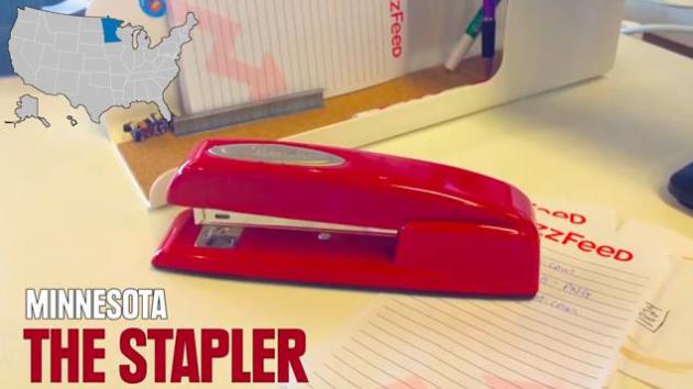
The 50 Coolest Inventions From All 50 States. The Stapler? Really? What about medical devices...or Spam? Not my list. Check out the video from Buzzfeed and
Yahoo Screen.
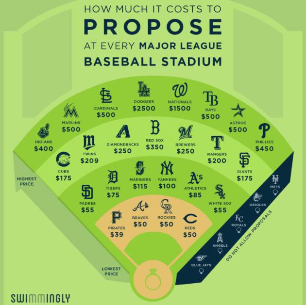
Here's How Much It Costs To Propose At Every Major League Baseball Park. $209 at Target Field? What a bargain! And yes, the proceeds go to charity. Here's an excerpt of real news you can use from
Swimmingly: "
Today
is Major League Baseball’s Opening Day, the start of the 2014 season.
That means it’s also the time of year for America’s second-favorite
pastime: the scoreboard marriage proposal. To step up your engagement
game, we reached out to all 30 MLB teams to find out the cost of
putting a ring (World Series or otherwise) on it at each stadium..."
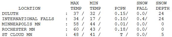
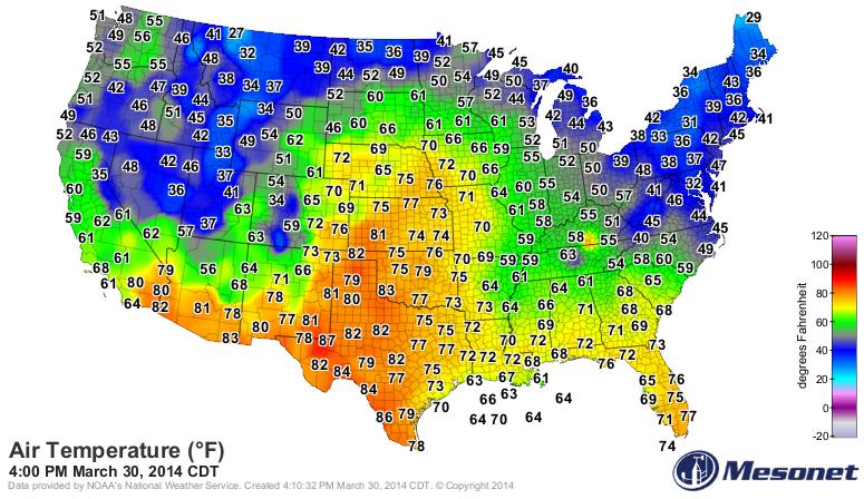
Land Of Mega-Extremes.
While temperatures flirted with 70 across southwestern Minnesota, and
tornadoes touched down not far from Canby, residents of Duluth and
International Falls were enjoying 30s with 24" of snow still on the
ground in both cities. Good grief.
* photo of funnel cloud over Saint Leo yesterday afternoon courtesy of @bwicky777.
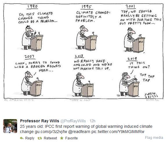
Climate Stories...
*
"The Hellish Monotony of 25 Years of IPCC Climate Change Warnings." Graham Readfern has the story at
The Guardian.
** Twitter cartoon credit
here.
Panel's Warning On Climate Risk: Worst Is Yet To Come. Justin Gillis has a good summary of the latest IPCC report in
The New York Times; here's an excerpt: "...
The
scientists emphasized that climate change is not just some problem of
the distant future, but is happening now. For instance, in much of the
American West, mountain snowpack is declining, threatening water
supplies for the region, the scientists reported. And the snow that does
fall is melting earlier in the year, which means there is less
meltwater to ease the parched summers. In Alaska, the collapse of sea
ice is allowing huge waves to strike the coast, causing erosion so rapid
that it is already forcing entire communities to relocate. “Now we are
at the point where there is so much information, so much evidence, that
we can no longer plead ignorance,” said Michel Jarraud, secretary
general of the World Meteorological Organization..."
MIT Scientist Responds On Disaster Costs And Climate Change.
FiveThirtyEight has an article from hurricane expert Kerry Emanuel from MIT; here's an excerpt: "...
The
increasing normalized trends in the U.S. were evident in convective
storms, winter storms, flooding events and high temperature-related
losses, and were almost statistically significant for hurricanes at the
conventional 95 percent confidence level.
In view of data like this, it’s very hard to accept Pielke’s confident
assertion that “[n]o matter what President Obama and British Prime
Minister David Cameron say, recent costly disasters are not part of a
trend driven by climate change...”

Wake Up To The Reality Of Climate Change. Here's an excerpt of an Op-Ed at
CNN that caught my eye, from former (Republican) Governor of New Mexico and U.S. Energy Secretary Bill Richardson: "...
We are now witnessing how it is changing our world: The past winter was the eighth-warmest on record. For 348 consecutive months -- 29 years
-- global temperatures have been above average. The latest IPCC report
finds that impacts from climate change are "widespread and
consequential" and they are being felt on every continent and in our
oceans. The world last year experienced 41 weather-related disasters
that caused damages totaling at least $1 billion. Over the past decade,
the western United States experienced seven times more large-scale wildfires than it did in the 1970s. Climate change has made it much more likely that we will suffer severe droughts like the one that recently swept across Texas and my home state of New Mexico..."
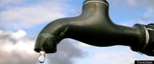
North America: Shifting Water. New Scientist examines how climate change will impact specific regions around the world. Here's an excerpt focused on North America: "...
Rain and storms will move northwards, flooding areas north of New York and leaving southern areas short of water.
Mexicans will have to do everything they can to preserve water and
escape the heat. Adapting to water deficits is not too hard: the key is
increased efficiency. But extra flooding is more problematic, with total
costs expected to increase tenfold this century. The US has the
capacity to adapt, but is struggling with misinformation and a lack of
political will..." (Photo: ThinkStock).
*
The Telegraph has a continent by continent breakdown of the risks and options related to a warming atmosphere and oceans.
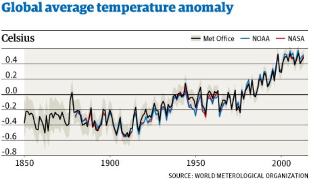
13 of 14 Warmest Years On Record Occurred In 21st Century - U.N. Here's a clip from a summary at
The Guardian: "
13 of the 14 warmest years on record occurred this century, according to the UN. Publishing its annual climate report, the UN's World Meteorological Organisation said that last year continued a long-term warming trend, with the hottest year ever in Australia
and floods, droughts and extreme weather elsewhere around the world.
Michel Jarraud, the WMO's secretary-general, also said there had been no
'pause' in global warming, as has been alleged by climate change
sceptics. “There is no standstill in global warming,” Jarraud said..."
Graphic credit: WMO (World Meteorological Organization) and The Guardian.
* A link to the latest IPCC WG2 Climate Summary is
here.
Food And Water Shortages May Prove Major Risks of Climate Change.
Scientific American has more on the implications of continued warming; here's a clip: "...
In that light, climate change becomes a risk management
proposition, particularly given the uncertainty about exactly how bad
impacts might become and when. The worst risks include sea level rise
for small islands and coasts, flooding, the breakdown of infrastructure
in the face of extreme weather, loss livelihoods forfarmers and fishers,
food insecurity and heat-wave deaths. Expect a big demand for energy for air conditioning
as the 21st century continues. Some of these impacts are already here,
from a meltdown of polar ice and glaciers everywhere to higher rates of
sea level rise than the IPCC predicted in the past..." (Image credit: NASA).
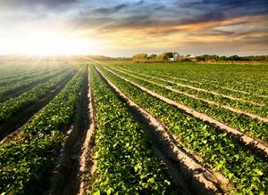
Climate Change Impact On Agriculture To Accelerate. Here's an excerpt of a longer look at the latest IPCC report and implications for agriculture, worldwide, courtesy of
The Guardian: "...
On average, we are looking at yield decreases. By the 2030s most of the changes in crop yields are negative," says Andy Challinor,
University of Leeds climate researcher, author on the paper, and on the
new IPCC report, too. "The second half of the century is when the
negative impact in yields becomes more common." The researchers found
this by comparing results from almost 100 independent studies—more than
double the number used in the IPCC's fourth assessment—that measured the
impact of higher temperatures on three of the globe's primary staple
crops: maize, wheat, and rice..."