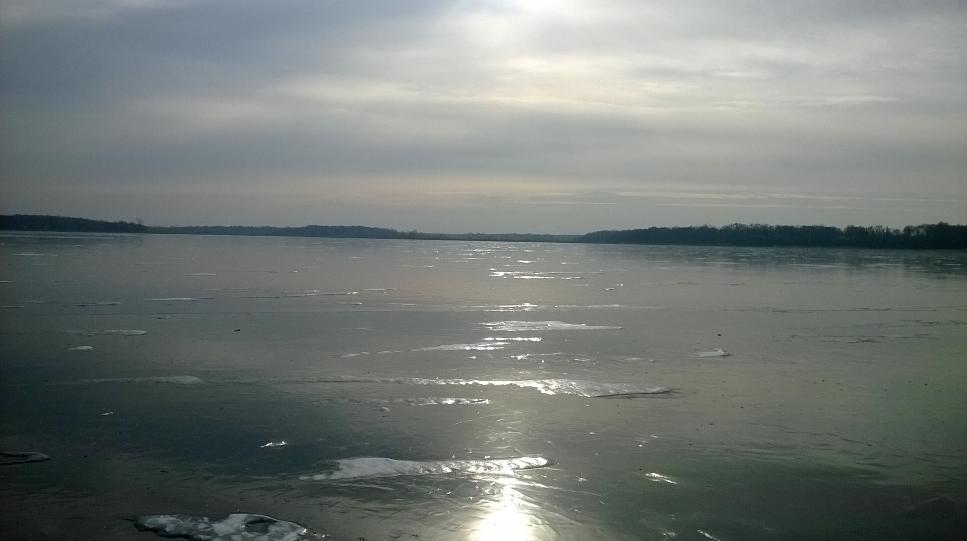
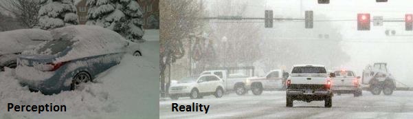
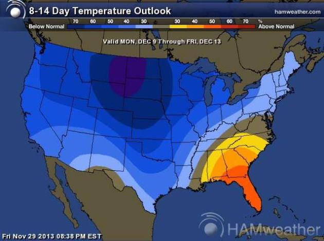
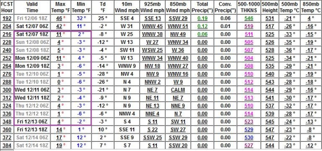
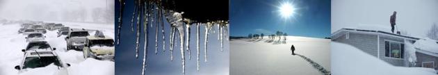
Thinking Snow
Deep
breaths. Not today - in fact roads will stay dry and cooperative into
Sunday for the drive home. Next week? Old Man Winter may finally drop
the hammer, treating you to a few white-knuckle, tire-spinning,
fist-waving commutes.
And really, it's time. The landscape
shouldn't look like frozen oatmeal. A December in Minnesota without snow
is like macaroni without the cheese, peanut butter without jelly,
Minneapolis without St. Paul.
It's Just Not Right.
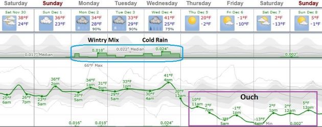
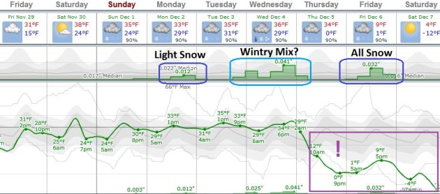
This far
out timing is tricky - predicting inch-amounts is a joke, but it appears
that a plowable snowfall is likely next week as the coldest air of the
winter, to date, steamrolls into Minnesota.
Light snow streaks in
Monday & Tuesday, but the main event comes Wednesday into Friday as a
series of sloppy southern storms track across the Plains. Wednesday
into Thursday temperatures may be just warm enough aloft for a wintry
mix in the Twin Cities (mostly snow north and west). A second storm
pushing northeast may drop all snow by Friday into early Saturday, with
cold air firmly in place. It's still too early for any more details,
other than to say that snow lovers may finally get their wish the latter
half of next week.
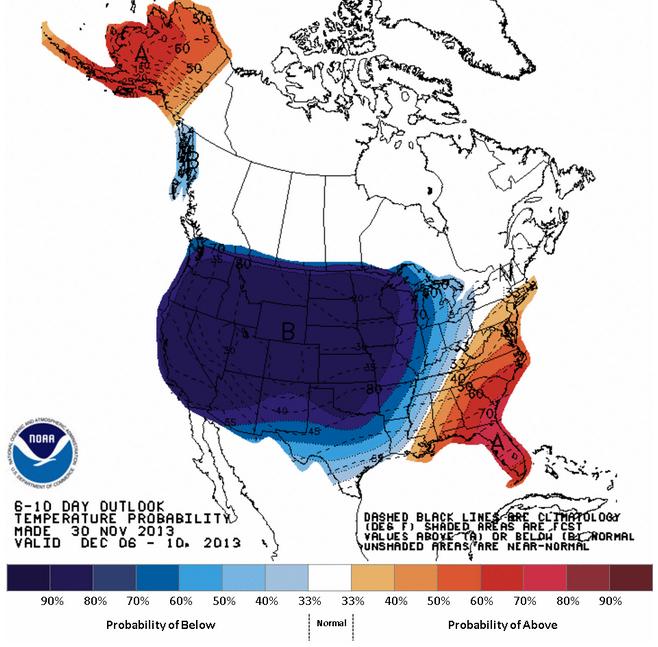
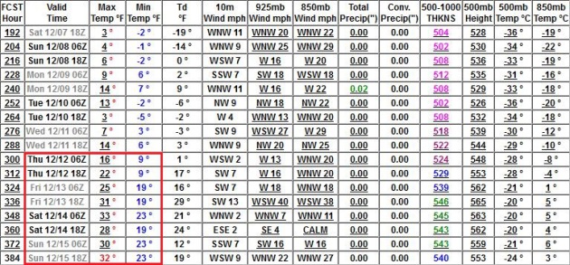
Here's a gasp-worthy number: the ECMWF
(European) model prints out a low of -17F in the metro a week from
tomorrow. Remember, the coldest jabs of winter are usually preceded by
significant snows.
Numbing cold lingers into the second week of December with a temperature rebound by mid-month.
You have a few more days to check the tires, plant the driveway stakes - and plan an urgent southern vacation.
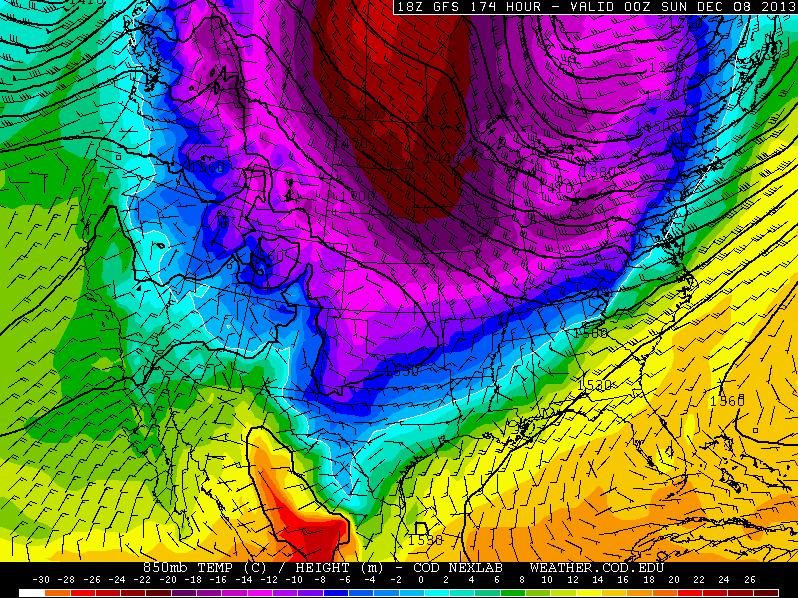
Winter Bares Its Fangs?
The models have been fairly consistent (all of them), showing
temperatures going off a cliff by the end of next week; the ECMWF
(above) showing a nippy low of -12F by Saturday night. As I've been
saying for years - fresh outbreaks of bitter air stand the best chance
of whipping up significant snow. Right now I see 3 waves of
precipitation: light snow Monday, a layer of warm air aloft sparking a
wintry mix from the Twin Cities on south/east on Wednesday into early
Thursday, then a third and final wave of snow developing Friday as a
storm tracks well east of Minnesota, more than enough cold air in place
for a dry, powdery snow - possibly prone to blowing and drifting. Stay
tuned. Graph: Weatherspark.
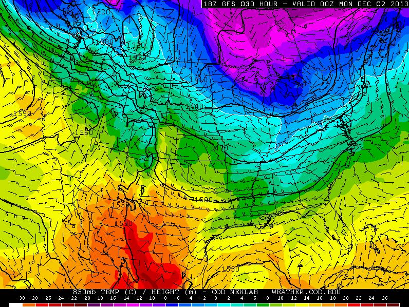
Siberian Breeze.
The data above is from NOAA's GFS model, showing roughly a week of
significant pain, highs in the single digits, lows dipping below zero,
with some recovery by mid-December.
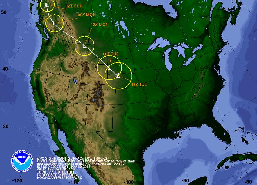
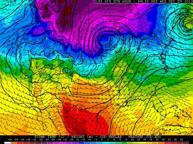
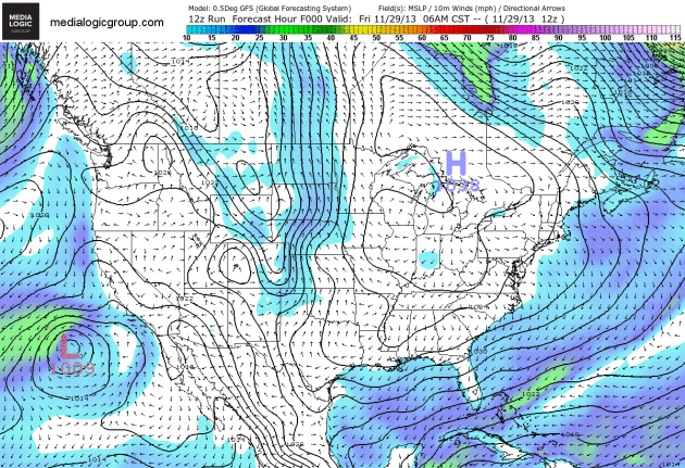
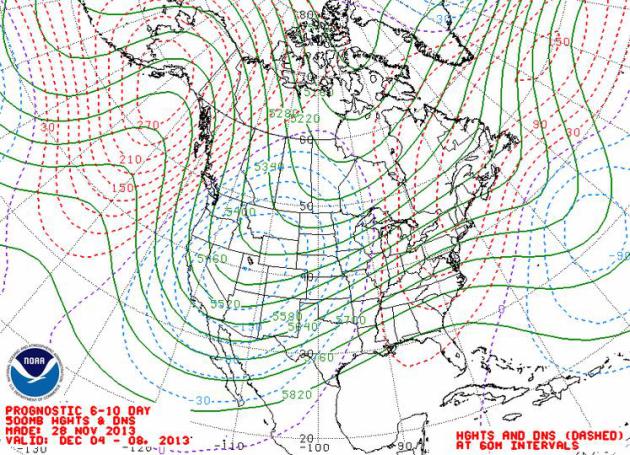
Storm Incubator.
The map above from NOAA shows predicted 500 mb heights (streamlines)
between December 4-8, a southwesterly wind component aloft capable of
whisking a series of storms across the Plains. As temperatures
progressively cool down the atmosphere should be cold enough for (all)
snow by the end of next week.
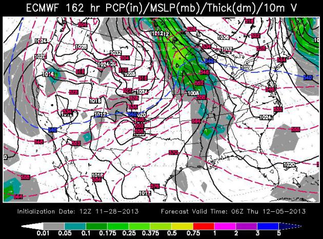
Wednesday Night - Thursday: Wintry Mix?
The ECMWF map above (WSI) valid midnight Wednesday night shows a storm
tracking across Iowa, enough warm air flowing north for a possible mix
of rain, sleet and snow from the Twin Cities southward to the Iowa
border. Precipitation may fall as mostly snow north and west of Willmar
and St. Cloud. It's too early for more specifics - and the forecast WILL
change over time as new, higher resolution data initializes the models.
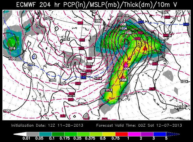
Friday PM Hours: All Snow.
Again, this is all still highly speculative (it always is), but ECMWF
guidance shows a second storm rippling north along a vigorous cold
frontal boundary pushing across the central USA, with enough cold air in
place for another wave of snow late Friday into Saturday morning. If
temperatures are in the teens or single digits this could be a dry,
powdery snow, prone to blowing and drifting.
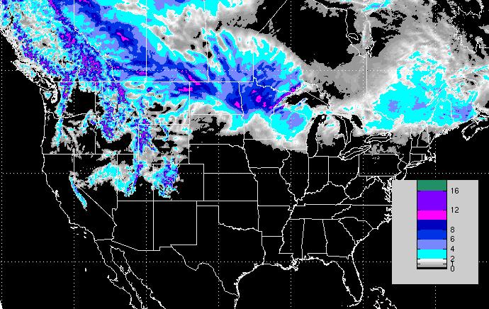
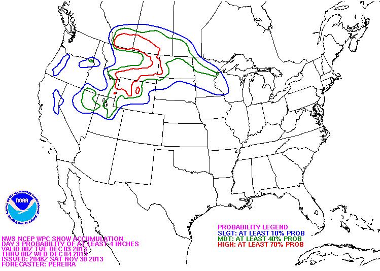
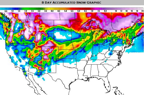
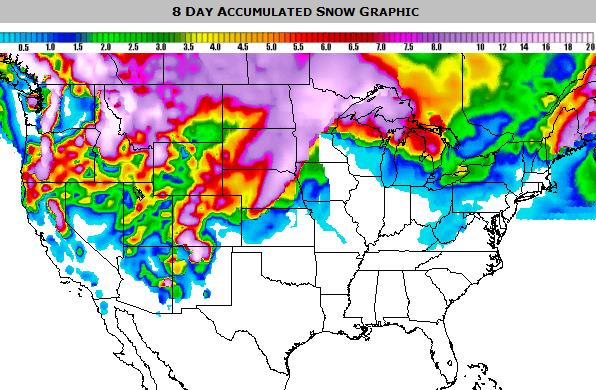
8-Day Snowfall.
Here is the latest NAM solution showing NOAA's prediction for 8-Day
snow accumulations; the best chance of a healthy pile of (very) plowable
snow from eastern Nebraska and the eastern Dakotas into the northwest
half of Minnesota. Map: Ham Weather.
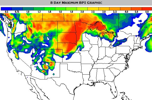
8-Day Blizzard Potential Index.
I start to get nervous anytime our calculated in-house Blizzard Index
goes above 3.0. Again, it's still very early to be making sweeping
pronouncements, but conditions may be ripe for blizzard or near-blizzard
conditions across the Dakotas and portions of western and northern
Minnesota the latter half of next week. Map: Ham Weather.
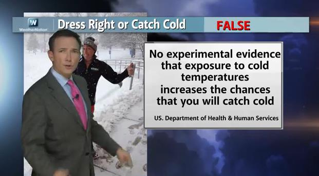
Cold Weather Myths. What Do You Really Know About Staying Warm?
A few of these were a (big) surprise to me, to be honest. As we track
the deepening chill we attempt to address a few cold weather myths: any
scientific validity to back up these claims? That's the subject of
today's
Climate Matters: "
Meteorologist
Paul Douglas has your cold weather trivia. The myths we have grown up
believing about the cold weather! These clues will help you stay warm as
the coldest air mass of the season is looking to set in the first week
in December. Brrr.... Happy Thanksgiving and Happy Hanukkah! These two
holidays fall on the same day this year, a very rare occurrence that
will not happen again for many years to come."
In Spite Of Nagging Drought - 2013 Was Second Best Year For Farming Since 1973. Here's an excerpt of a good summary from
CNBC: "...
In
crop projectiongs this month, the USDA increased its estimated total
for corn to 1 percent over last year's estimate, and soybean production
up 3 percent from the 2013 estimate. Corn will see total production at a
record level of nearly 14 billion bushels. Those higher estimates came
despite many areas of Iowa, Minnesota and the Upper Midwest dealing with
late planting, along with some late-season drought conditions. Net farm
income is also on the rise. It's forecast to be $120.6 billion in 2013,
up 6 percent from 2012's estimate of $113.8 billion. After adjusting
for inflation, 2013's net farm income is expected to be the second highest since 1973, according to the USDA..."
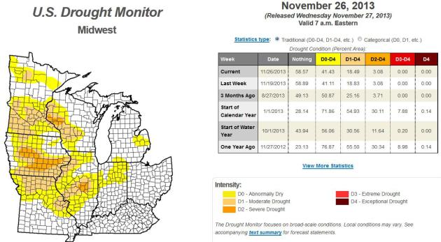
* the latest U.S. Drought Monitor update for the Upper Midwest, Great Lakes and Ohio Valley is
here.
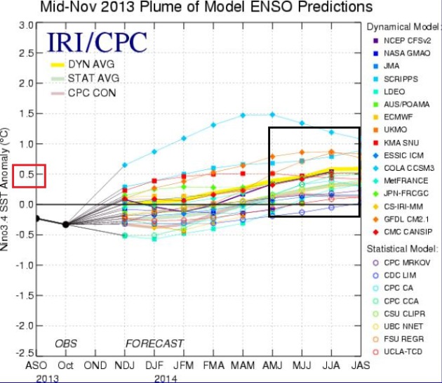
Growing Signs Of El Nino In 2014. The graphic above is from NOAA's latest
ENSO update;
after years of a perpetual La Nina cooling phase of the equatorial
Pacific there are growing signs of a possible El Nino warming phase
developing by early 2014; which may, in turn, favor milder than normal
temperatures, and a southern storm track across the USA into the latter
half of winter. It won't be declared an official El Nino event until and
unless we go at least 3 consecutive months with sea surface
temperatures .5C warmer than average.
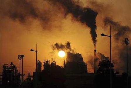
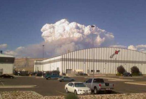
Battling Flames In Forests, With Prison As The Firehouse.
The New York Times has the story of how many states are throwing more manpower on the front lines of major wildfires; here's an excerpt: "...
As
federal agencies have cut costs during the budget standoffs in
Washington, further decreasing the size of a firefighting work force
that has already been reduced by 40 percent since the 1980s, the burden
of fighting wildfires has been shifted to states and local
jurisdictions, even as they struggle under the weight of a sluggish
economy. Prison crews, cheap and dependable, have emerged as a solution
as wildfires burn bigger, hotter and longer each year and take up a
growing portion of the United States Forest Service budget. (In 2012
alone, federal agencies spent $1.9 billion on wildfire suppression, just
shy of the record, set in 2006.)..." (Photo above: Grand Junction office of the National Weather Service).
The Daniel Fast: A Diet From God? Step away from the turkey - just fruit and vegetables going forward, ok? Here's a clip from an interesting story at
The Atlantic: "...
Daniel
said he and his friends would eat a diet of only vegetables (“pulse”).
After 10 days, they grew healthier and stronger than the Babylonians,
and his diet became a small demonstration of his opposition to the
King’s power. This passage is occasionally used to encourage Christians to resist the corrupting influences
of the outside world. But several years ago, some Protestant churches
began to take the “diet” aspect of Daniel’s story literally. Motivated
by both faith and fitness, today many protestant Christians around the
country are, like Daniel, occasionally limiting themselves to fruits and
vegetables for 21-day increments..."
Image credit above: "
flickr/A Gude/Waiting for the Word/Frapestaartje."
"Action": From Sports Star To TV Star. The New Yorker
has a fascinating article about how ESPN grooms it's on-air talent,
making that hard turn from sports star to TV "personality"; here's the
excerpt: "...
ESPN, the Megalodon of sports broadcasting, has no
shortage of retired millionaires sending job applications: both the
N.F.L. and the N.B.A. host annual seminars for players interested in
broadcasting, and a current Pittsburgh Steeler recently asked if he
could work as an unpaid intern. But finding linebackers who understand
the difference between B-roll and a boom mike can be difficult. “They go
from a job where you’re trained to say as little as possible to a job
where you need to say as much as possible,” Gerry Matalon, a senior
producer who helps run ESPN’s on-air talent development, said recently.
In 2008, to remedy the problem, ESPN created a talent department staffed
with several performance coaches like Nash..."
Climate Stories...
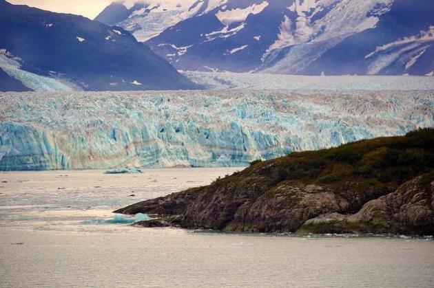
The Sound Of Global Warming: Melting Glaciers Sizzle In Warm Water. Science World Report has the article; here's the intro: "
What does global warming sound like? Scientists may have just found that out. They've recorded and identified the sizzle of glacier ice as it melts into the seas. The noise, caused by trapped air bubbles squirting out of the disappearing ice, could provide clues to the rate of glacier melt and help researchers better monitor fast-changing polar environments..."
Photo credit above: "
What
does global warming sound like? Scientists may have just found that
out. They've recorded and identified the sizzle of glacier ice as it
melts into the sea." (Photo : Flickr.com/blmiers2).
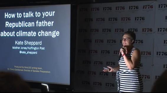
Can You Talk Turkey With Your Climate-Change-Denying Relatives This Thanksgiving? After reading this (and checking out the video) I wasn't sure whether to laugh or weep; here's an excerpt from
Huffington Post: "...
Thanksgiving
is coming and you know what that means, folks: dinner with your
climate-change-denying relatives. You know who I'm talking about. The
uncle who thinks sunspots are the reason the planet's getting warmer.
The cousin who thinks dinosaur farts are to blame. Grandma, who also
thinks President Barack Obama is a lizard from space.
Maybe you try to avoid these conversations at your Thanksgiving dinner.
But there usually comes a point in the evening when, having exhausted
all conversation about how lovely the new trivet is and yes, the traffic
yesterday was just the worst, other topics come up. Sometimes you start
talking about the weather … and then all of a sudden you're arguing
about whether Al Gore's breath is really the reason it's been so hot
lately..."
Chris Hadfield: We Should Treat Earth As Kindly As We Treat Spacecraft. Here's an excerpt of a thoughtful, timely piece from NASA astronaut Chris Hadfield, in
Wired Science: "...
While
I was on the space station, I used Twitter to ask hundreds of thousands
of people what they would like me to take a picture of. Resoundingly,
the answer was “home.” Everyone, from all around the world, wanted to
see their hometowns. I found that thought-provoking. After millennia of
wandering and settling, we are still most curious about how we fit in
and how our community looks in the context of the rest of the world. A
curiosity of self-awareness, now answerable by technology. This is
where the answers to our problems will start..."
Image credit above: "
Astronaut Chris Hadfield was commander of Expedition 35 on the International Space Station, from December 2012 to May 2013." Tavis Coburn.
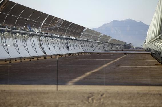
Solar Energy Was America's Sole New Power Source In October.
My dream (among others) is to be able to power my Tesla Model S, for
free, with affordable solar power and battery storage in my garage. That
day may be fast approaching. Here's a clip from
The Atlantic: "
In October, power plants generating 530 megawatts of electricity came online in the United States. And every single electron put on the grid came from the sun,
according to a report released today. It’s possible to make too much of
the fact that solar energy was the sole source of new electricity
capacity in US that month. After all, the completion dates of power
plants can be random. That’s particularly true for complex,
multibillion-dollar, fossil fuel power stations that can take years to
build and are subject to oversight by state regulators..."
Photo credit above: "
A solar thermal power plant." (Reuters).
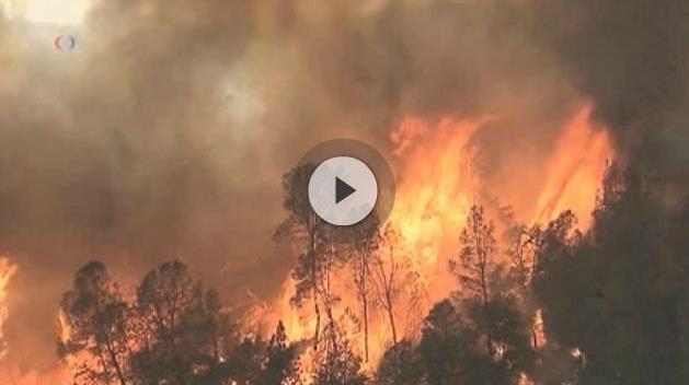
High Intensity "Megafires" A New Global Danger. Here's an excerpt (and video clip) from VOA,
Voice of America: "
The
term “megafire” was coined about a dozen years ago in the United States
in light of the fact that only 1-2 percent of all wildfires had come to
account for more than 85 percent of costs and burned area. Similar
trends are happening elsewhere. "In the western United States, we have
larger fires occurring over a longer period of time. The fire season -
what we have to deal with - is really changing," said Bill Kaage,
Wildland Fire Operations Director for the U.S. Park Service at the
National Interagency Fire Center (NIFC) in Boise, Idaho. The numbers are
startling. According to the NIFC, 82,591 wildfires in the U.S. burned
nearly 1.2 million hectares in 1985. Yet it took only 67,774 fires to
consume more than 3.7 million hectares in 2012 - more than a threefold
increase..."
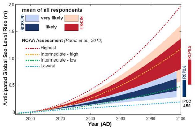
How High Will Sea Levels Rise? Let's Ask The Experts. Here's a snippet from a comprehensive article at
The Washington Post: "...
So here's one way to get a better sense for the broader debate: A new study
in Quaternary Science Reviews simply asked 90 experts on sea-level rise
for their projections, based on their work. This isn't brand-new
scientific research, but it does give a very useful overview of the
current state of research. The results? The experts, on average, think
global sea levels will rise somewhere between 0.7 and 1.2 meters by the
end of the century if global warming continues unchecked (that's between
2.2 and 4 feet)..."
Acidifying Oceans Alarm Hundreds Of Scientists. Here's a clip from a story at
Environment News Service: "...
Climate
change is causing the world’s oceans to acidify at rates not seen for
the last 55 million years, and the only way to moderate this danger is
to reduce human emissions of carbon dioxide, conclude 540 scientists
from 37 countries in a new report. Their conclusion is the outcome of
the Third Symposium on the Ocean in a High CO2 World that took place in
Monterey, California in September 2012. The findings of these experts
were presented in a report to the Conference on Climate Change that took
place in Warsaw from November 11 to 22..." (Photo credit: Alamy).