Signs of Spring...
Thanks to my good friend and old college
roommate, Matt Dux, for the picture below out of Kansas City, MO. To be
honest, I think he was rubbing it in, but he texted me this picture just
to let me know that it was in the 80s there yesterday. He also
mentioned that the trees and bushes were well on their way to budding
out!

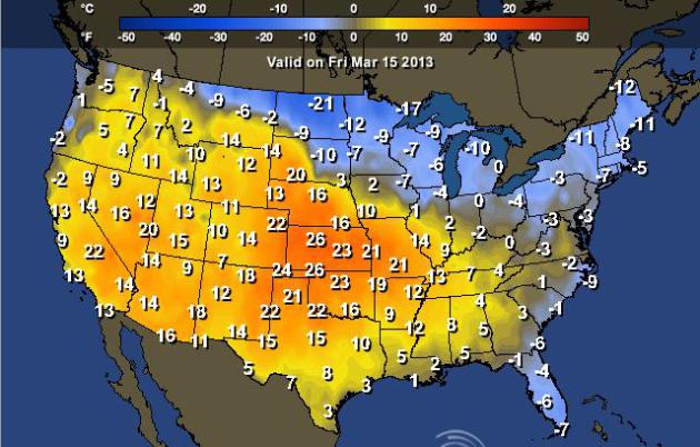
Tale of Two Seasons
The national temperature map across the
country on Friday looked pretty wild. While it was still cool across the
far north, much of the nation was warm to hot. Also note how far north
the warm air was across the mid-section of the nation.

Friday High Temperatures From Normal
This was how much above or below normal high temperatures were expected to be on Friday.
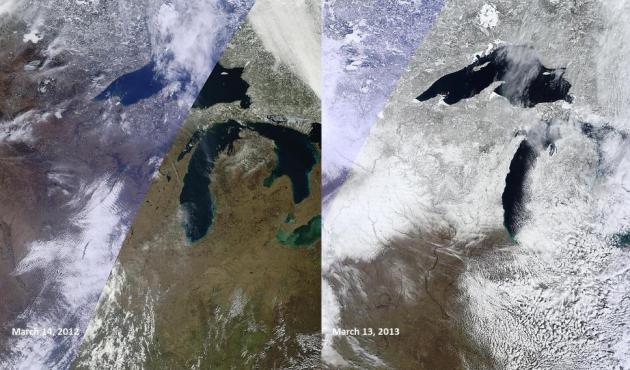
March Snow Cover 2012 vs 2013
Here's a satellite shot from above the
Great Lakes Region showing the difference between the snow cover this
year vs. last on March 14th. Note how much whiter it is this year!
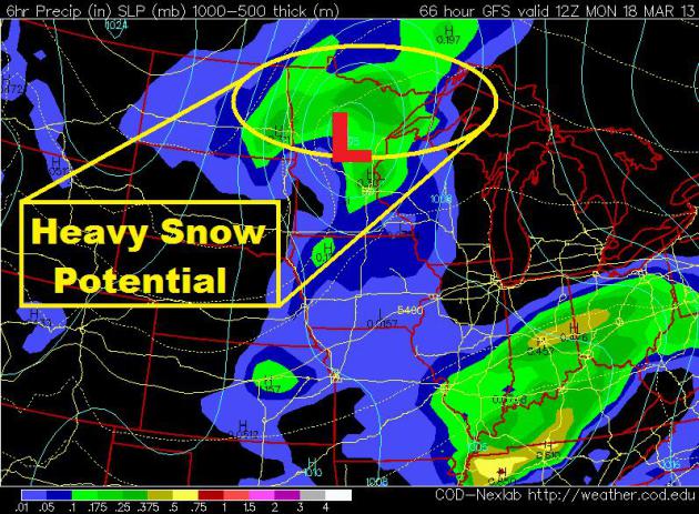
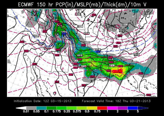
Next Big Snow Maker?
Another big storm looks to be developing across the Upper Mississippi Valley by late weekend early next week. The overall trend on this storm has been a little farther north than previous runs. That would keep the heaviest snow across parts of North Dakota and far northern Minnesota. This is still a developing storm, so things will likely change... Stay tuned!
Warm Thoughts
Thanks to my good friend and colleague,
Bryan Karrick, for the picture below... must be nice! Hoping he'll bring
some of that nice Hawaiian weather back with him when he returns to
Minnesota! Keep the pictures coming Bryan!

From Minnesota to Hawaii, Then Hawaii to Minnesota...
Thanks to my good friend, Sarah Frakes, for the picture below who help start a Minnesota based company last year called Traveling Tap.
The group they had on Friday was a bachelorette party, the bachelorette
was apparently from Hawaii and was LOVING Friday's falling snow! How
about that!

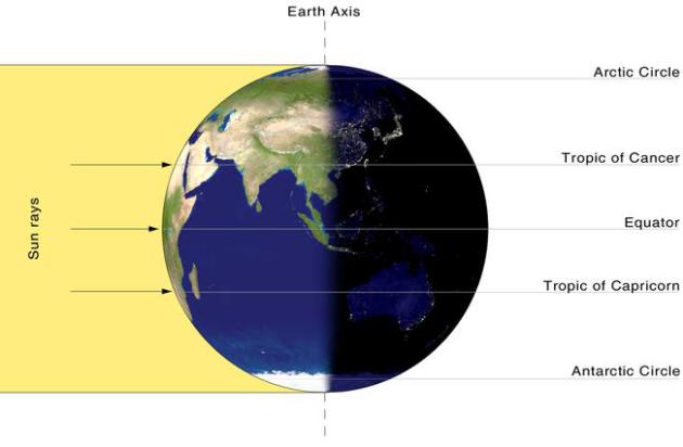
Spring Really Is Just Around the Corner
This Wednesday, the sun's most direct rays
will pass over the Equator signifying the Vernal Equinox or the first
day of Spring for the Northern Hemisphere. Day and night hours across
the globe are nearly equal.
"On the equinox, night and day are
nearly exactly the same length – 12 hours – all over the world. This is
the reason it's called an "equinox", derived from Latin, meaning "equal
night".
However, even if this is widely accepted, it isn't entirely true. In reality equinoxes don't have exactly 12 hours of daylightThe March equinox occurs the moment the sun crosses the celestial equator – the imaginary line in the sky above the Earth’s equator – from south to north. This happens either on March 19, 20 or 21 every year. On any other day of the year, the Earth's axis tilts a little away from or towards the Sun. But on the two equinoxes, the Earth's axis tilts neither away from nor towards the Sun, like the illustration shows."
Read more from TimeAndDate.com HERE:
Another Sure Sign of Spring
Now here's a sure sign of Spring... green
grass! Thanks to Wade Weidner for the picture below from the Target
Center, home of the Minnesota Twins, whos first home game is April 1st,
weather permitting of course!

Forecast Still Looks Cool and Somewhat Snowy
The images below are the temperatures a few
thousand feet off the ground. This is a fairly good indication of what
temperatures are like across the country. Note that even with this
recent mild spell for many in the southern half of the country, extended
forecasts look a bit chilly by next weekend.
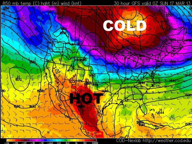
Saturday, March 16th
Saturday temperatures will be cooling for
those in the northeast quadrant of the nation, while temperatures in the
southwest quadrant of the nation will still be quite warm, perhaps a
little 'hot' side for some?
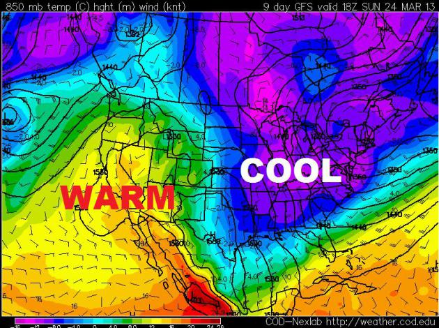
Sunday, March 24th
Look at how different it could be
nationwide next weekend. A modified chunk of cool Canadian air looks to
invade the eastern half of the country, while the hot weather in the
Southwest looks to be squelched a bit.
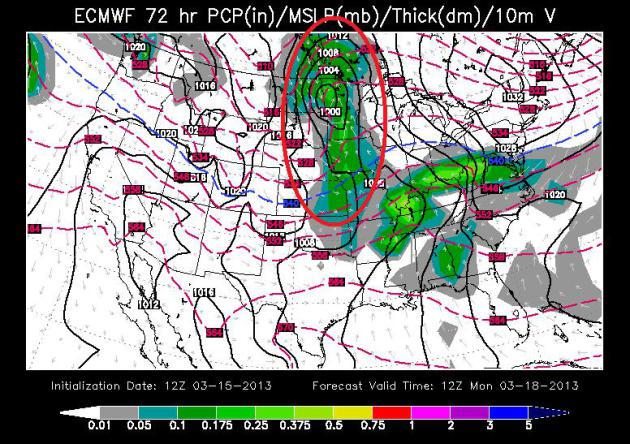
Stormy Next Week?
There will be at least a couple of storm
systems that we'll have to watch next week. It appears the first system
will rear its head in the High Plains/Upper Mississippi Valley by late
Sunday. By Tuesday, it'll be exiting the Great Lakes Region, but not
before dumping some decent snow tallies for folks across the far north.
5 Day Snowfall Forecast
The extended forecast (GFS American Model)
suggests that there will be decent snowfall potential for some across
the far north over the next 5 days.
Another Late Week System
Extended models are also picking up on
something by late next week. Mainly for those across the Deep South.
However, this is the storm that will help to draw those cooler
temperatures in to the Gulf Coast States.
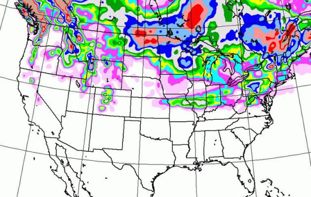
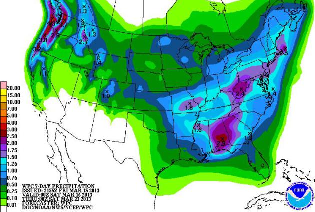
Long Range Precipitation Forecast
NOAA's HPC 7 day precipitation forecast
suggests that these storm system will have the capability of bringing
several inches of precipitation to some in the eastern part of the
country!
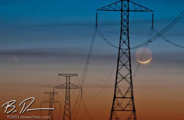
Comet Pan-STARRS
Thanks to my good friend for this amazing
shot of Comet Pan-STARRS! Bill has a great eye for pictures! You can see
more of his work at mnwxchaser.com HERE:
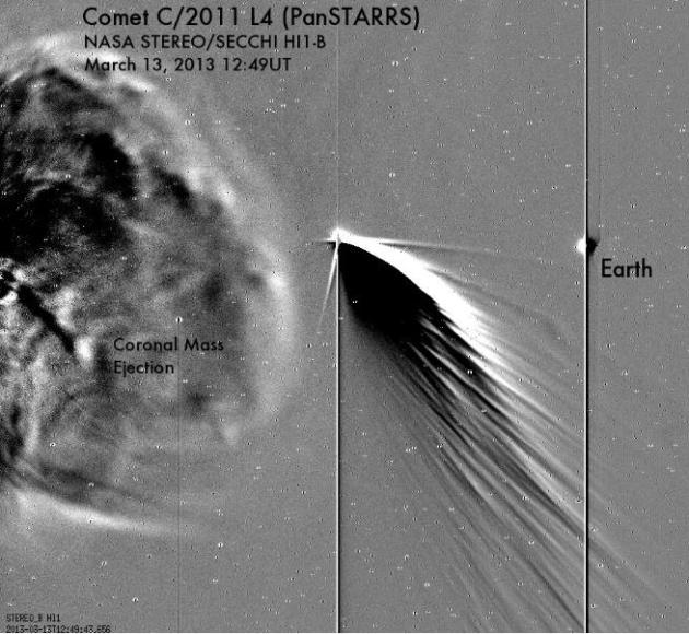
Here's another incredible shot from NASA...
"Explanation: After appearing in a
popular photo opportunity with a young crescent Moon near sunset,
naked-eye Comet PanSTARRS continues to rise in northern hemisphere
skies. But this remarkable interplanetary perspective from March 13,
finds the comet posing with our fair planet itself - as seen from the
STEREO Behind spacecraft. Following in Earth's orbit, the spacecraft is
nearly opposite the Sun and looks back toward the comet and Earth, with
the Sun just off the left side of the frame. At the left an enormous
coronal mass ejection (CME) is erupting from a solar active region. Of
course, CME, comet, and planet Earth are all at different distances from
the spacecraft. (The comet is closest.) The processed digital image is
the difference between two consecutive frames from the spacecraft's
SECCHI Heliospheric Imager, causing the strong shadowing effect for
objects that move between frames. Objects that are too bright create the
sharp vertical lines. The processing reveals complicated feather-like
structures in Comet PanSTARRS's extensive dust tail."
Thanks for checking in, have a great rest of your weekend!
Don't forget to follow me on Twitter @TNelsonWNTV