White-Knuckle March Commute
Nature rarely moves in a straight line. Spring
in Minnesota is usually one step forward, two steps back. March is a
troubled month, capable of blizzards, floods, even tornadoes. Snow on
the ground keeps northern cities chilly, while a rising sun angle heats
up the Deep South. The result: huge north-south temperature extremes,
capable of spinning up memorable storms.
It's unusual to pick up so much snow from an
Alberta Clipper, but this one is tracking slower than usual,
compensating for a lack of Gulf moisture. Snow should taper by
afternoon. By then a cool 6-9 inches of new snow should be on the
ground, probably the second heaviest snowfall of winter so far, behind
the 10.5 inches that fell December 9.
Yes, we've been spoiled. Dr. Mark Seeley reports
February was only the 2nd cooler than average month since June, 2011.
My gut is telling me March will be cooler than average too; a far cry
from last year's 70s, early ice-outs and flowers in full bloom in late
March.
On the blog below: Washington D.C. is about to get "snow-questered"; 6-12 inches possible tomorrow.
Some melting is likely here later this week with upper 30s. That said, spring will come only reluctantly this year.
*
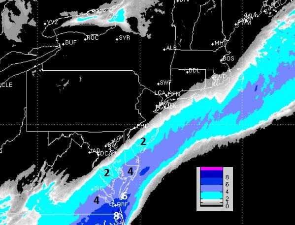
Storm is showing signs of hooking farther north, spreading heavy wet
snow into Philadelphia, New York, and far western suburbs of Boston.
* Heaviest amounts west of I-95, where some 12"+ snowfall amounts are possible Wednesday night into Thursday.
*
4-8" still expected downtown D.C. Wednesday, over 12" northern/western
suburbs of Virginia and western Maryland (west of I-270).
* High water content (1-2" liquid) may mean an enhanced risk of downed tree limbs and power outages.
*
This won't be the scope or intensity of the blizzard in early February,
but facilities may be significantly impacted later this week.
*
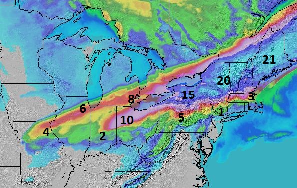
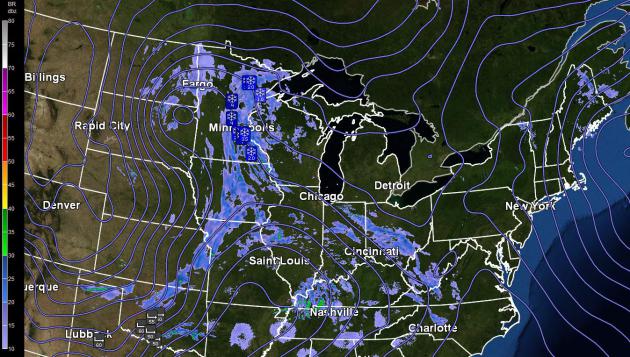
6-9" snow next 24-36 hours Twin Cities to Chicago; the same system that
will redevelop into a coastal storm impacting the Northeast.
Northeast Snow Potential Increases.
The same clipper putting down a 250-mile wide carpet of 6-10" snow will
spin up a major coastal storm Wednesday night into early Friday; rain
right along the coast, but potentially heavy, wet snow just inland.
Winds will reach 30 mph, just shy of blizzard criteria, but high water
content may increase the potential for power outages, especially west of
I-95.
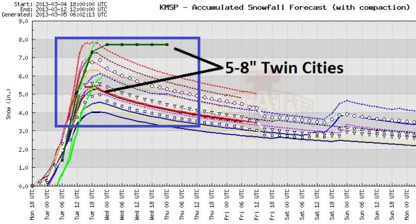
Twin Cities Totals.
Minneapolis/St. Paul will be digging out from 5-9" of snow by Tuesday
afternoon, enough to shovel, plow and create white-knuckle commutes this morning.
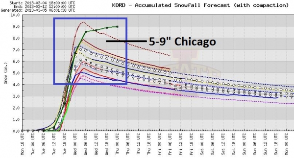
Chicago Gridlock. Expect travel delays today in Chicago, where 6-10" of snow is likely, sparking delays and cancellations at O'Hare and Midway.
Windy City Mess.
Models are converging on a solution of 6-9" in Chicago during the day
Tuesday. Conditions on land and in the air should rapidly improve
Wednesday.
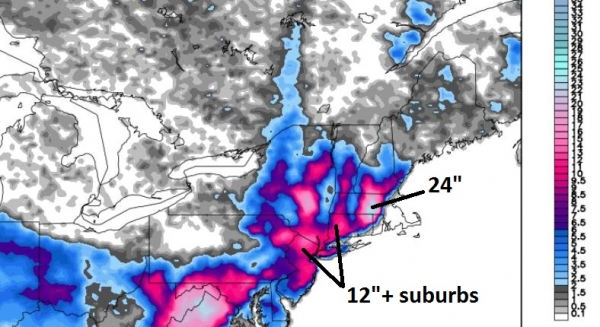
A Major Northward Jog.
The Midwestern clipper will energize a storm over Virginia, forecast to
veer farther northeast than earlier thought, pushing a shield of heavy
rain and wet snow across Pennsylvania into New York and interior New
England. The heaviest snowfall amounts will fall just inland, a mix of
rain and snow for coastal New Jersey and much of Long Island, but heavy
wet snow from New York into the suburbs of north Jersey and western
Connecticut.
Snow Inflation.
Confidence levels are still low for 12"+ amounts over the far
northern/western suburbs of New York; the situation should crystallize
during the day Tuesday as new data arrives. I still expect heavy wet
snow for Washington D.C., and the potential for a sloppy snowfall is
increasing over time for New York and New England.
Clues Pointing to a Potentially Major Shift.
We look for continuity between all models, and from run to run (there
are 4 new model runs every day). The trend is for the storm to hug the
coast and recurve northeastward, threatening much of interior New
England with a mix of heavy rain and wet snow, the best chance of
plowable snowfall amounts just inland.
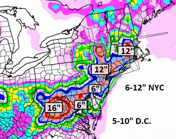
Snowquestered.
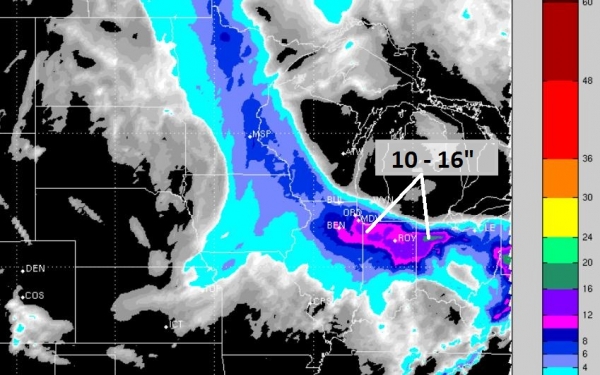
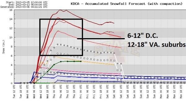
Washington D.C. is still facing the biggest snowfall in nearly 3 years
Wednesday and Wednesday night. 4-8" of slushy, wet snow is expected in
D.C. - closer to 4" for Annapolis and Baltimore, but over 12" may pile
up from Frederick into Loudon and Fairfax counties in Virginia, with
some 16"+ amounts over far northern Virginia.
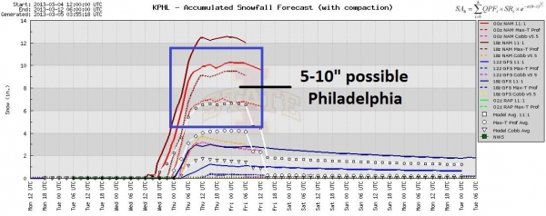
Delaware Valley Slop-Storm.
The latest models print out about 5-6" for Philadelphia; more possible
in Bucks county. Coastal New Jersey may see mostly rain, with some 5-10"
amounts over northern and western New Jersey; again the greatest focus
for heavy wet snow is west of I-95.
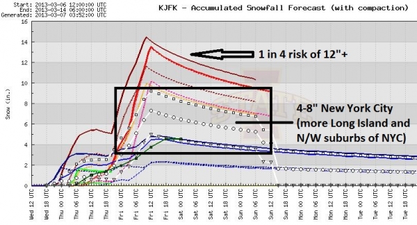
New York Numbers.
Confidence levels are still low; the morning model run on Tuesday
should confirm whether NYC will pick up another major snowfall on
Thursday. Models print out nearly 2" liquid, rain and heavy wet snow.
Factoring in 30-35 mph winds Thursday the potential for power outages
for the city and suburbs has increased in the last 12 hours.
Summary: The Confidence Level for at least
4-8" of wet snow in Washington D.C. is a 7, on a scale of 1-10; but only
a 5 in Philadelphia and 4 in metro New York. It looks like mainly rain
in Boston, but over a foot of snow is possible well inland, over central
Massachusetts.
Do We Laugh Or Do We Cringe? Gallery Of Lower Thirds.
The text at screen bottom on your favorite news show, that gives the
name of the person on-screen and some compelling information, you know,
the bane of television news, and one (big) reason why we all have ADHD.
Here's an excerpt of a very funny story at
TVSpy.com: "Who doesn’t need a chuckle to start the week? The folks at
Buzzfeed have put together a hall of shame/fame of lower thirds
aimed at the gleeful 13-year-old living inside all of us. While we all
make mistakes, some of the lower thirds are funny because they’ve been
taken out of context and some are just plain goofy. We’ve chosen a
couple you can see after the jump. But don’t ask
Norman Fineman to laugh. He’s seen it all. You can view the gallery by
clicking here..."
 Climate Stories....
The Most Important Figure About The Oil Sands
Climate Stories....
The Most Important Figure About The Oil Sands. Here's an excerpt from Simon Donner at
Maribo: "
Are
the oil sands a "carbon bomb"? Will the construction of new pipelines
unleash this "bomb" on the climate? There's lots of confusion about
these questions. On Friday, the U.S. State Department's released
an assessment that stated the Keystone XL pipeline would have a
negligible climate impact, essentially because a market analysis
suggested that other options will arise for transporting additional
carbon from the oil sands. Environmentalists are crying foul, energy and
industry experts are arguing both sides, and pundits are wondering why
the report was released on a Friday afternoon, when few people follow
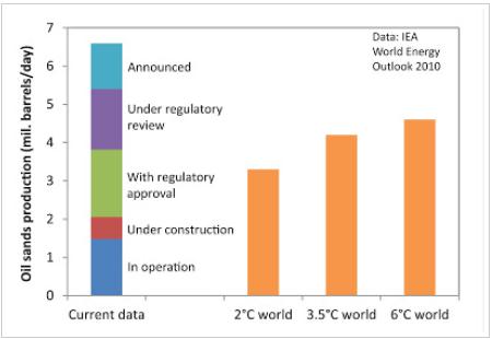
the news. It's hard to know who to trust. The figure (above), based on
one figure made by Keith Stewart from Greenpeace and shown to me by
Mark Jaccard in the fall, suggests the answer to both questions could
be considered "yes", but not in the way people normally suggest..."
Graphic credit above: "
The first column is existing,
planned and announced oil sands projects; the orange bars are oil sands
production in the IEA future scenarios. Production is assumed to be 80%
of capacity, following the IEA methods."
Greg Hunt's Unusually Cool U.S. Winter That Wasn't. A harsh winter for the USA in terms of temperatures? Nope. Here's an excerpt from
readfearn.com: "...
Even
in a warming world, you’ll still get record cold events – it’s just
that the hot ones are outnumbering the cold ones. In Australia, for
example, for every record cold temperature there’s three record hot ones. In the US, a 2009 study
found record high temperatures were outstripping record colds by two to
one. I had a quick look at this unusually cold US winter which Greg
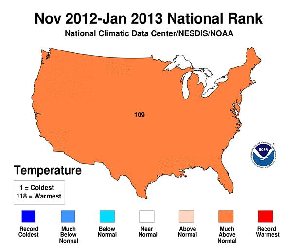
Hunt alludes to. The government’s National Oceanic Atmospheric Administration
has all the figures. Incidentally, January 2013 is the 335th
consecutive month where global average temperatures have been above
average. Final rankings for the US winter are not expected to be out for
a week or so yet but, so far, the chilly winter turns out not to have
been that chilly after all. In fact, the period November 2012 to
January 2013 ranks 109th warmest in a record going back 118 years..."