SICK Windsurfing
My colleague, Aaron Shaffer, has taken up the sport of wind surfing recently and said that Friday's wind in the Minneapolis was PERFECT! The image below is of Aaron and his teacher, Gene, who is almost 69 years young! Way to go you guys! Regardless if you'll be wind surfing or not, jumping in a lake is probably a good idea at some point over the next week or so with temperatures as warm as they'll be!
Watch Aaron's video HERE:

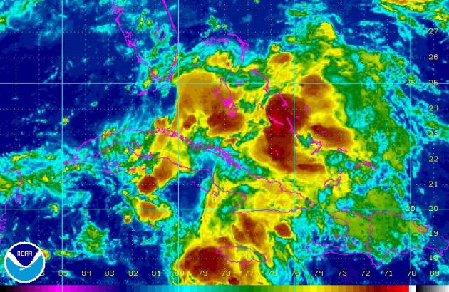
Tracking Chantal?
Ever since Chantal dropped below tropical storm status last week, she has had a hard time regaining strength as wind shear has been one of her biggest enemies. If you were a tropical wave/hurricane, warm ocean water temperatures and weak winds aloft would be your ally. Strong winds aloft have helped to keep Chantal struggling to find a tropical identity, however, moisture associated with the remnants of Chantal will like find its way into the Lower 48 over the weekend.
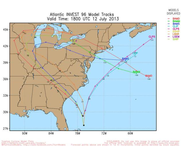
Spaghetti Models (hungry yet?)
The graphic below suggest the potential paths that the remnants of Chantal may take over the coming days. It looks like different colored spaghetti noodles doesn't it? The different colored lines represent different weather model solutions.
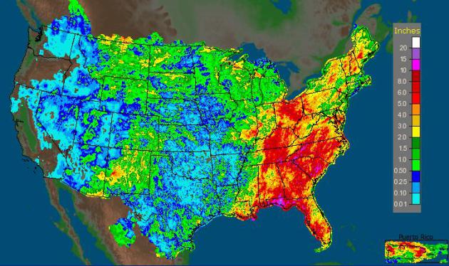
Soggy Southeast
Look at how much rain some spots have seen over the last 14 days. Radar estimates of rainfall in a few locations east of the Mississippi River suggests rainfall amounts of nearly 6" to 12" or more! No surprise that so many locations have been dealing with flooding lately.
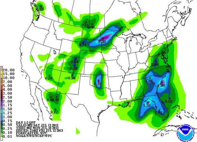
More Rain on the Way...
Unfortunately, folks in the Southeast/Mid-Atlantic region can't catch a break. We've had a tremendous amount of rain over the past couple of weeks and it looks like it will continue through the weekend. Thanks to a stalled front and the remnants of Chantal, some spots could see an additional 1" to 2" or more through PM Sunday. Also note the heavier pocket of rain potential across the Midwest. This is in response to thunderstorm potential, some of which could be strong to severe at points this weekend.
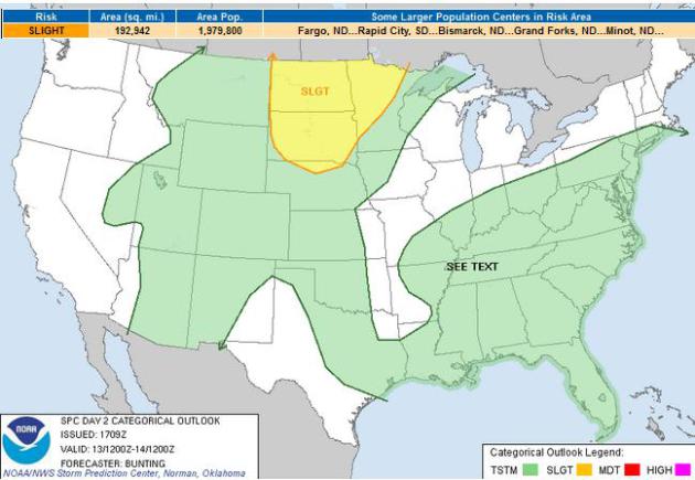
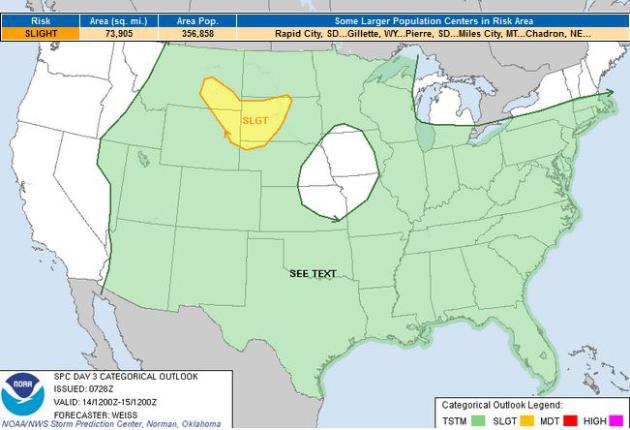
Severe Threats
The Storm Prediction Center has issued a SLIGHT RISK of severe weather for parts of the Midwest and High Plains on Saturday and Sunday. This activity will be bubbling up on the periphery of some extreme heat and humidty that will keep the middle part of the country very July-like through the weekend.
Severe Threat Saturday
Severe Threat Sunday
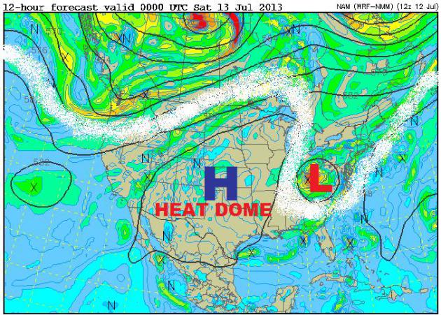
July Heat Dome Continues...
The image below shows the current state of our atmosphere. The white line represents the jet stream or strong upper level winds. This is the dividing line between warm summery air to the south and cooler air to the north. Note how it is once again fairly wiggly. The ridge of high pressure in the west and central part of the country is where our heat is currently sitting (thunderstorms are developing on it's northern periphery) and the trough of low pretty in the Ohio Valley is sitting nearly stationary with rain/thunder on it's eastern flank.
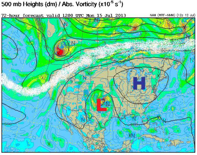
Retrograding Low...?
Ok - this is something that we
don't see too much of. A low in the Northeast that moves WEST all the
way to the Rocky Mountains?? Extended weather models suggest that the
low currently sitting in the Ohio Valley with retrograde or move west to
the Rockies over the next several days. WEIRD! The image below shows
what the weather map will look like by Monday.
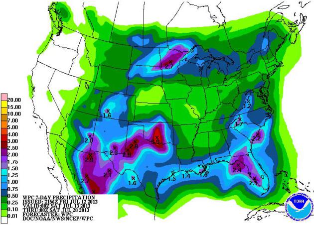
Much Needed Rainfall
The retrograding upper level low
mentioned above is not only weird, but it could bring some much need
and significant drought relief for folks in the Southern Plains and near
the Four Corners region. The image below shows NOAA's 7 day rainfall
forecast, note the heavier rainfall potential across parts of the
Southern Plains and the Southwest.
Thanks for checking in, have a great weekend ahead!
Don't forget to follow me on Twitter @TNelsonWNTV