Indefinite Pause
I appreciate every Minnesota season, but summers
here defy the imagination: a warm blur of water, family and
cabin-related injuries. If I could I'd freeze-frame, memorize and replay
every July. Not nearly as soggy as June, July is Nirvana, one
luxurious, postcard-perfect month before talk of the State Fair &
Back To School Sales.
Yes, I'm a fan of July, in spite of the peaking
heat and drippy dew points. Like all good things in life a Minnesota
July is a something to be unwrapped slowly, a gift - fleeting and
ephemeral.
No, I'm not on the payroll of the Minnesota
Chamber of Commerce. But for a kid weened on the Jersey Shore, dodging
syringes, jellyfish & hurricanes, there is nothing that compares
with Minnesota's lakes, parks and trails. This is why most of us don't
run off to Arizona for good.
A frontal boundary arrives with a few strong to
severe T-storms today; any hail will impact a tiny percentage of the
state. We dry out tomorrow on northwest winds as dew points dip into the
comfortable 50s.
90F may return next weekend with more T-storms and antiperspirant-defying levels of humidity.
Summer came late this year, but we're about to seriously make up for lost time.
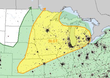
Tuesday Severe Threat. NOAA SPC expects enough
low-level moisture, instability and wind shear for a few strong to
severe storms later today. The biggest risk: large hail and
straight-line wind damage, but a few isolated tornadoes can't be ruled
out. The slight risk area includes the Twin Cities, Omaha, Kansas City,
Des Moines, Chicago and Detroit.
"
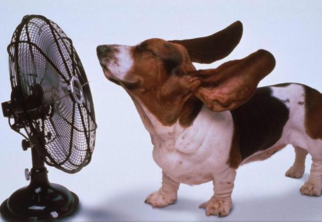
Hey Paul - it was interesting to read your explanation of the
phrase "Dog Days" being derived from the ancient Greeks belief that
Sirius, the Dog Star added to the heat from the sun during the summer. I
would venture to guess that most folks are unaware of that and simply
think that it refers to the weather being so hot and humid some days
that the family dog seeks shelter in the shade and just lays around
panting rapidly with its tongue hanging out. That's the only explanation
I ever heard growing up in the wilds of North Dakota during those
swelting August "Dog Days"! I think most folks would relate to that
explanation, don't you?"
- Clay Hagen, Plymouth
Clay, I can definitely relate to your
explanation. My dog (Leo) is trying to find a few cool spots, and he
relates as well. But if you're looking for the origin of the expression I
stand by my explanation. To be honest, I was surprised too - I honestly
thought the phrase came from watching pets grapple with the heat. Those
ancient Greeks knew how to have a good time, huh? Thanks for the note
and the chuckle.
Stormiest Day Of The Week.
Today should be the wettest day of the next 4-5 days, a few hours of
heavy showers and T-storms. We dry out and cool down (slightly) tomorrow
as dew points drop into the 50s, before heating up again late week.
It's early, but ECMWF guidance suggests Sunday will be the wetter day of
the weekend with the best chance of T-storms.
84 Hour Outlook. An eastbound
cool front sparks strong to severe T-storms from the Upper Midwest into
the Great Lakes and Ohio Valley today, while the soggy remains of
Chantal pinwheel toward the Bahamas and possibly Florida by late week,
and the west stays bone-dry. Source: NOAA.
Hurricane Forecasting Remains A Challenge.
Especially predicting storm intensity. Track outlooks continue to slowly
improve, but our worst fear, as meteorologists, is going to bed with a
Category 1 hurricane, only to wake up the next morning to a Category 4.
Here's an excerpt of a story at
The Sun Herald in Mobile, Alabama: "
We're
due for a big one, some say. Every year now since 2004 and 2005 -- the
years of Hurricanes Ivan, Dennis and Katrina -- the Gulf Coast has
been "due" for a storm season worse than the year before. Now, one month
into the official hurricane season, forecasters expect a double-digit
number of storms to develop. As many as 13 to 20 named systems --
storms with 39 mph winds or higher -- are estimated for the coast by
the National Oceanic Atmospheric Administration this year. Three to six
of those may be major hurricanes, categories three or higher. If those
numbers sound familiar, that's because weather experts have been
predicting more active weather patterns since the mid-1990s, says Bill
Williams, director of the Coastal Research Center at the University of
South Alabama..."
Tropical Storm Chantal: Comparing Model Projections. It's still early, but in today's edition of
Climate Matters
we take a look at Chantal and ask the question many residents of the
Gulf and East coast are wondering - will it impact the USA? "
Chantal
is the 3rd named storm of the Atlantic season to date. WeatherNation
Chief Meteorologist Paul Douglas says the models are in fairly good
alignment and Chantal could impact Barbados and Martinique over the
next 48 hours. The big question mark comes for later in the week and
into the weekend. Will there be an impact to the Southeast U.S?"
Read more here: http://www.sunherald.com/2013/07/07/4781460/hurricane-forecasting-remains.html#storylink=cpy
*
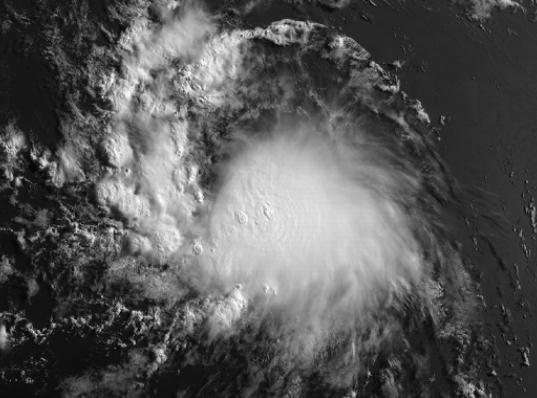
Tropical Storm Chantal was packing 40-45 mph winds
as of late Monday, racing to the west-northwest at 26 mph, slowly
strengthening over time. The projected track takes Chantal across the
Caribbean this week as a strong tropical storm; intensification into a
significant hurricane is unlikely into Friday.
* Long-range models suggest a
heightened risk for the Bahamas and Florida
by the end of this week and weekend, with potentially heavy rains and a
moderate storm surge. It's too early to say with any certainty whether
Chantal will track into the Gulf of Mexico or turn up the East Coast.
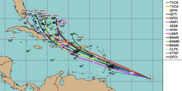
Early Path Projections. The models are all fairly
well aligned and in agreement as to the west/northwest track of
Chantal; tropical storm force (40-65 mph) winds impacting Puerto Rico,
Haiti and eastern Cuba by late week. A track partially over mountainous
terrain, especially latter half of the week, will limit how strong
Chantal can become, but there is still at least a 1 in 3 risk of a
Category 1 hurricane over the Bahamas by late Friday or Saturday of
this week.
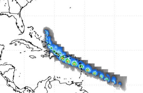
Another Perspective. Here is NOAA's high-res GFDL
projected path for Chantal, showing a potential track just south of the
U.S. Virgin Islands, pushing into Puerto Rico and the Dominican
Republic later this week as a strong tropical storm.
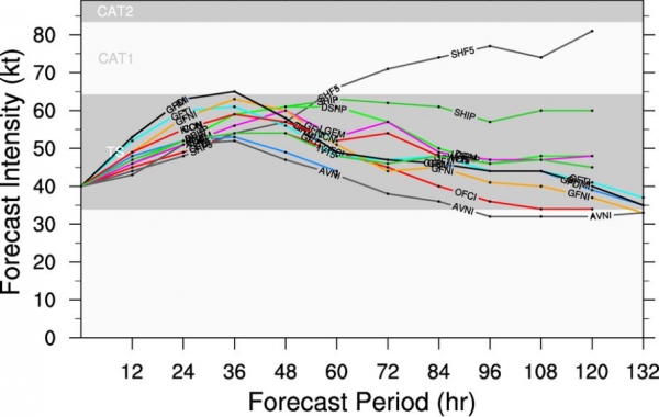
Intensity Predictions. Most of the models keep
Chantal at tropical-storm-force; sustained winds generally under 70
mph. Only one of the "Ships" models intensifies the storm into a
Category 1 hurricane 72 hours from now. In all probability Chantal will
remain a tropical storm most of this week.
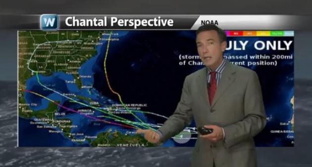
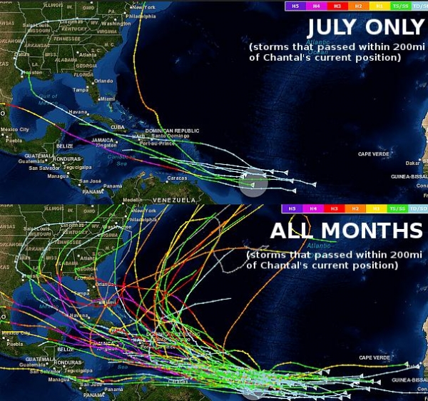
What Comes Next? The maps above show climatology;
previous storms and where they tracked. The trop graphic shows all July
storms within 200 miles of Chantal's current location - a bias into
the Gulf of Mexico. The bottom graphic shows all storms that have
formed within 200 miles (in any month), showing more solutions that
turn up the East Coast. Confidence levels beyond 5-6 days are still
very low with this system. A strong Bermuda High will prevent Chantal
from veering quickly into the Atlantic, and some of the long-range
models do bring the soggy remains of Chantal up the East Coast by the
weekend or early next week. (images courtesy of NOAA and Capital City
Weather Gang).
Summary: Chantal is a Cape Verde class tropical
storm sweeping off the coast of Africa, coming about a month earlier
than usual. Conditions are ripe for slow strengthening, with at least a
30-35% risk of a Category 1 hurricane pushing into the Bahamas by
Friday of this week. Impacts to Florida, the East Coast or Gulf Coast
are still highly speculative. With this briefing we're sending up an
early flare - we just want to make sure this is on your personal radar;
we'll update you as conditions warrant and the threat level to
Caribbean and U.S. interests rises or falls.
Europe Floods To Cost Insurers Up To $4.5 Billion: Swiss Re.
Reuters has the details: "
Floods
in central Europe last month may cost insurance companies $3.5-4.5
billion, only half of one previous estimate but more than was paid out
for the last major washout in 2002, the world's second biggest
reinsurer said on Monday. The forecast from Swiss Re compares to an
earlier warning from a damage modeling agency that losses could top $8
billion. That, and its estimate of a $300 million hit for its own
results, saw shares in Swiss Re and some other sector firms rise. The
flooding in early June forced Czech soldiers to erect metal barriers
and pile up sandbags to protect Prague's historic centre after days of
heavy rains swelled rivers and forced evacuations from low-laying
areas. Emergency workers, soldiers and volunteers worked desperately to
shore up flood defenses in towns along the Danube and Elbe rivers as
the high water moved downstream in the following days, with Germany
among the worst-hit..."
Why So Many Flood Maps Are Still Out Of Date. Here's an excerpt of an interesting read from
Propublica: "
The
Federal Emergency Management Agency’s flood insurance maps are
critically important for millions of Americans who live in flood-prone
areas. The maps determine the annual premiums for flood insurance,
which is required by law for homeowners with federally backed mortgages
who live in high-risk areas. But many of the nation’s flood maps are
woefully out of date. ProPublica talked with David R. Maidment, a
professor at the University of Texas at Austin who has advised FEMA on
flood mapping, about why the data behind modern maps is 10 times as
accurate as the older data and why half of Texas still doesn’t have
up-to-date maps..."
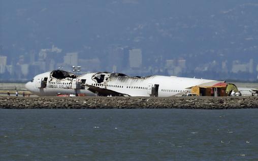
San Francisco's Boing 777 Crash: Why It Was Survivable. Here's a clip of a fascinating article at
Time: "...
While
more than 100 people were injured in Saturday’s crash, some seriously,
these relatively good outcomes typically happen after what are called
“low-impact survivable” incidents when the plane has slowed to 140 or
150 m.p.h. (225 to 240 km/h), are due in part to changes in airplane
construction to include better safety doors, seat technology, exit
chutes, fireproofing and incident protocols. “Thirty years of design
improvements have made a huge difference in the ability to get everyone
off the plane in less than two minutes,” explains Larry Rooney, a
veteran pilot, National Transportation Safety Board–trained accident
investigator and executive vice president of the Coalition of Airline
Pilots Associations. In addition to plane modifications,
emergency-response crews are equipped with ever better technology. The
first task of responders at a fiery crash site is to secure escape
paths for victims using foam and water. “You establish where the fire
is and attack from a downwind position,” explains Tom Kinton, an
aviation consultant, who has had many roles running Boston’s Logan
Airport over his 35-year career, including director of aviation and
CEO. “You want to push the fuel away from the victims coming down the
chute and buffer the route with foam,” he says..."
Photo credit above: "
The wreckage of Asiana Airlines
Flight 214 that crashed upon landing Saturday at San Francisco
International Airport sits on the tarmac Monday, July 8, 2013 in San
Francisco. Investigators said the Boeing 777 was traveling
"significantly below" the target speed during its approach and that the
crew tried to abort the landing just before it smashed onto the runway
on Saturday, July 6. Two of the 307 passengers aboard were killed." (AP Photo/Jeff Chiu)
How The Brain Creates "The Buzz" That Helps Ideas Spread. Here's an excerpt from
The UCLA Newsroom: "
How
do ideas spread? What messages will go viral on social media, and can
this be predicted? UCLA psychologists have taken a significant step
toward answering these questions, identifying for the first time the
brain regions associated with the successful spread of ideas, often
called "buzz." The research has a broad range of implications, the study
authors say, and could lead to more effective public health campaigns,
more persuasive advertisements and better ways for teachers to
communicate with students. "Our study suggests that people are
regularly attuned to how the things they're seeing will be useful and
interesting, not just to themselves but to other people," said the
study's senior author, Matthew Lieberman, a UCLA professor of
psychology and of psychiatry and biobehavioral sciences and author of
the forthcoming book "Social: Why Our Brains Are Wired to Connect..."
A Brief History Of Sliced Bread. Prepared as only
Mental Floss can; here's a clip: "
Every
new and clever innovation seems to win the praise of being “the
greatest thing since sliced bread.” Have you ever wondered, how long
has it actually been since sliced bread was first sliced? The answer:
sliced bread is turning 85 this year! The concept of sliced bread first
came about thanks to Otto Rohwedder, an American inventor from Iowa.
Rohwedder constructed the first loaf-at-a-time bread-slicing machine
for commercial use, but initially had some trouble selling it, or even
the idea of it; many bakers expressed concerns about the bread becoming
stale too quickly or simply falling apart if sliced..."
* photo above: Brad Birkholz.
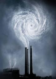
Climate Stories....
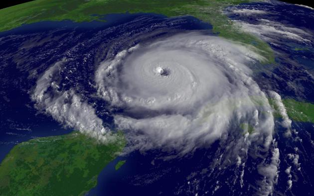
Hurricanes Likely To Get Stronger And More Frequent: Study. Meteorologist Andrew Freedman has the story at
Climate Central; here's an excerpt: "...
With
the population of coastal areas growing daily and sea level on the
rise, how these monster storms may change as the climate continues to
warm is an increasingly urgent question facing climate scientists,
insurance companies, and public officials. A new study by Kerry
Emanuel, a prominent hurricane researcher at MIT, found that contrary
to previous findings, tropical cyclones are likely to become both
stronger and more frequent in the years to come, especially in the
western North Pacific, where storms can devastate the heavily populated
coastlines of Asian nations. Emanuel's research showed the same holds
true for the North Atlantic, where about 12 percent of the world's
tropical cyclones spin each year. Emanuel's study casts doubt on what
had been the consensus view of most climate scientists — that in most
ocean basins, tropical cyclones are likely to become less frequent as
the world warms, but that the storms that do occur are likely to
contain stronger winds and heavier rains..."
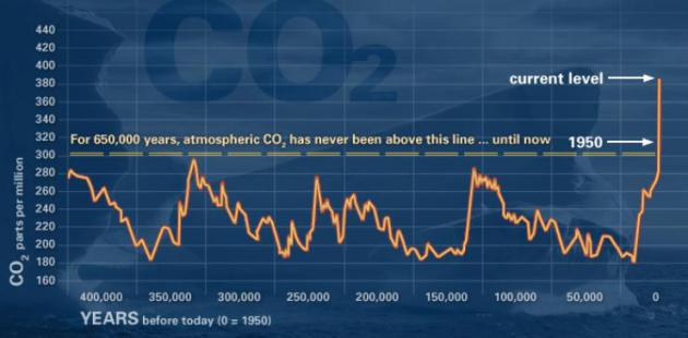
Climate Change: How Do We Know? Here's an explanation of the graph above, from a
NASA web site focused on the overwhelming amount of evidence surrounding climate change: "
This
graph, based on the comparison of atmospheric samples contained in ice
cores and more recent direct measurements, provides evidence that
atmospheric CO2 has increased since the Industrial Revolution." (Source:
NOAA)
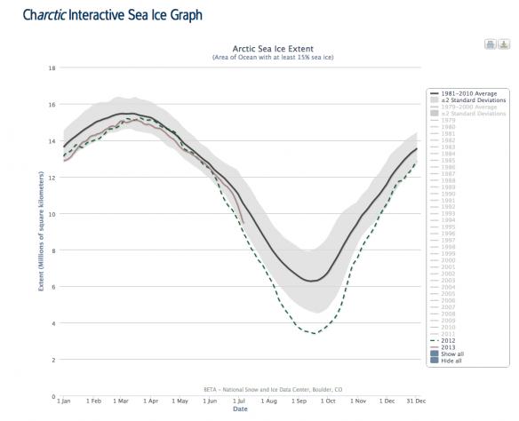
Arctic Sea Ice Melt Speeds Up. Here's the intro to a story from Minnesota climate scientist Greg Laden at
scienceblogs.com: "
Earlier
in the northern summer, it looked like the rapid melt of Arctic Sea
ice we’ve been seeing over the last several years was happening again,
but rather than being a record year, it was merely tracking along the
lower side of the distribution of the long term average. Last year, in
contrast, the amount of sea ice hit an all time low early in the year
and then broke previous records into tiny icy pieces. One of the
reasons last year’s ice melt was so dramatic is that an early storm
churned up the ice and got melting going a bit early. This year, there
was no early churning up event, but over the last several days of June
and beginning of July, the rate of sea ice melt has suddenly increased
dramatically and this year’s track is looking like it may come close to
catching up to the previous year’s unprecedented extreme..."
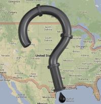
State Department Admits It Doesn't Know Keystone XL's Exact Route. Say what?
DeSmogBlog has the details; here's the intro: "
The
State Department's decision to hand over control to the oil industry
to evaluate its own environmental performance on the proposed Keystone
XL tar sands pipeline has led to a colossal oversight. Neither Secretary
of State John Kerry nor President Barack Obama could tell you the
exact route that the pipeline would travel through countless
neighborhoods, farms, waterways and scenic areas between Alberta's tar
sands and oil refineries...."
How To Talk To Your Parents About Climate Change.
It's been interesting seeing the evolution in thought with my father, an
uber-conservative. Lately he's been taking a closer look at the data,
and peer-reviewed research, and he's pretty much reached the same
conclusion that most reach when they actually dig into the science:
somethat has, in fact, changed, and our release of greenhouse gases is
probably impacting climate (and weather events). Here's an excerpt from
Huffington Post: "
Maybe it will turn out that human intelligence won't be favored by selection, and we'll soon grow ourselves into oblivion.
But no matter what our eventual fate, I think it would do our souls
good to at least try to slow down our self-destruction. After all, just
because a penchant for murder and Kardashians seem to be inherent human
flaws doesn't mean we shouldn't do our best to minimize them. I don't
expect public opinion on climate change will be swayed by columnists
and pundits preaching to their choirs. Those who want to ignore the vast scientific evidence
on the subject have likely already skipped to the comment section
below to try to convince you that since I'm not shouting these things
naked from a wooden hut in the middle of a bog, I'm a hypocrite and
deserve to be ignored. For those still reading, I have a suggestion.
Most of us don't have millions of dollars to go toe-to-toe with the
disinformation campaign being waged by the oil and gas industry. But
most of us do have living parents. So let's talk to them about climate
change. Because if we can't convince the people who love us more than
anything in the world to take action on climate, who can we convince?..."
Global Warming And Economists - SuperFreakonomics Is SuperFreakingWrong.
The Guardian has the story - here's a clip: "...
Dr.
Levitt writes that "agnostics grumble that human activity accounts for
just 2% of the global carbon dioxide emissions" but never tells the
reader that these are gross emissions, not net emissions. In fact, humans are responsible for the entire net increase in carbon dioxide
– 40% of the carbon dioxide in the atmosphere at this time has come
from human-caused emissions. How could a professor of business not
understand the difference between net and gross emissions? A
significant part of his chapter on global warming involves a description
of the entrepreneurs attempting to find a geo-engineering solution to
the problem of global warming. While discussing these techniques, Dr.
Levitt writes that carbon dioxide is not poisonous – in fact,
acceptable levels of carbon dioxide in modern buildings can be notably
higher than the level in the atmosphere yet still be safe for humans to
breathe. While this is true, Dr. Levitt fails to recognize that
concerns about CO2 levels in the atmosphere have nothing at all to do
with breathing CO2 but rather with the fact that it causes the
atmosphere to warm..."
Photo credit above: "
Steven Levitt, author of SuperFreakonomics, in Chicago, 2005." Photograph: Tom Maday for the Guardian.