Reader Pet Peeves
"Paul, why does the forecast CHANGE so much from
day to day. Knock it off!" I hear you, and I feel your pain. I wish the
future was more predictable. Short answer: there are 4 major computer
runs every day and scores of different models. Every run taps new data
(satellites, weather balloons, surface reports) that "initialize" these
computer simulations. This often means tweaks and revisions/changes to
the forecast, which should (in theory) get a little more accurate as you
approach the day/time in question.
Another irritant: "Paul, I watch 4 TV channels
& get 4 different forecasts. Why?" In the end forecasting boils down
to interpretation. Which model are you betting on? How will local
factors impact the forecast? The best predictions use computers &
the human element (past history, intuition - a bit of gut feel).
It's like sausage - you really don't want to know how it's made.
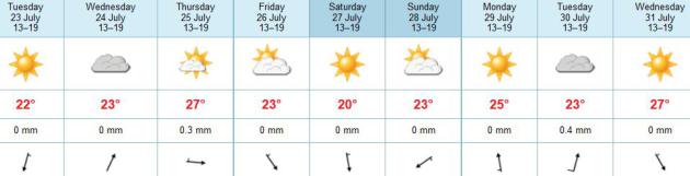
Canada is leaking again; expect blue sky &
comfortable 50-degree dew points. A few showers late-week mark the
leading edge of a real cool front; by Saturday you may need a sweat
shirt up north. Sunday looks milder, a better lake day.
El Nino may be returning, a warmer phase in the Pacific. Could that mean a milder winter?
Hey, a guy can dream...
A Drier, Cooler Week. ECMWF guidance shows a big
drop in humidity levels today, with dew points dipping into the low 50s.
Clouds increase late Wednesday, the best chance of showers and possible
thunder Thursday, then another transfusion of Canadian air in time for
the weekend. Highs Saturday may hold in the low to mid 70s in the metro,
maybe some 60s up north. Sunday looks a few degrees warmer, probably
the better day for the lake. No hideous heat in sight.
Cooler Than Average. The normal high now ranges from
83-84F in the Twin Cities, and temperatures will run a good 2-5F cooler
than average into at least early next week. You may need a sweatshirt
if you're up early Saturday, with wake-up temperatures in the low 50s,
maybe some 40s in the Brainerd and Alexandria Lakes area.
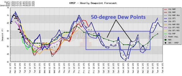
Mostly-Comfortable. With the exception of Thursday,
dew points are forecast to be in the 50s most of the week into early
next week. The approach of a frontal boundary may cause a brief upward
spike in dew points Thursday, but this week will be MUCH more
comfortable, overall, than last week. Graphic: Iowa State.
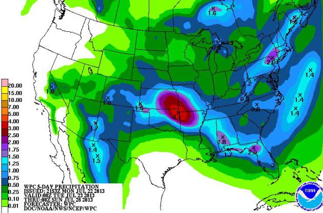
Family Of Cooler Fronts. A shift in the pattern with
buckling jet stream winds will spill cooler, drier air southward,
setting the stage for heavy T-storms over the Central Plains, and
significant showers and T-storms over the East Coast thru at least
midweek, with a potential for localized flash flooding. 5-Day QPF
Rainfall Forecast courtesy of NOAA.
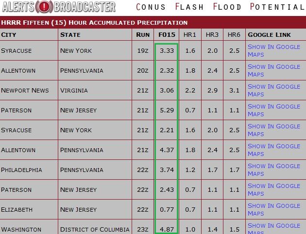
Flash Flood Potential. Our internal models show a
significant risk of flash flooding from Syracuse, New York to the
suburbs of New York City, Philadelphia and Washington D.C. - with some
3-5" amounts possible over the next 15 hours, exceeding flash flood
guidelines.
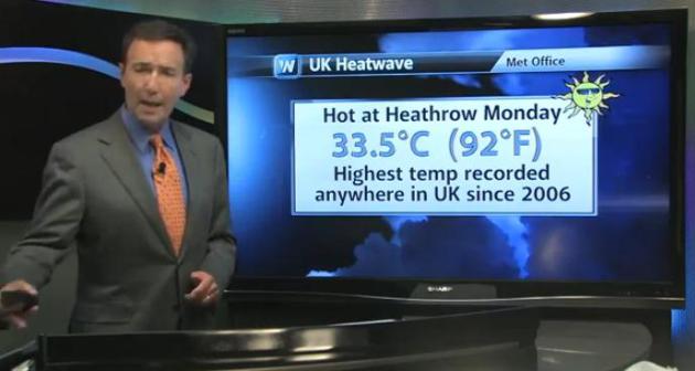
It's A Boy! Did you hear? If you have a pulse, and
don't live in a cave, odds are you have. The Dutchess of Cambridge gave
birth to a healthy baby boy Monday afternoon, in the midst of the worst
heat to grip the U.K. since 2006. Yes, always a weather angle. In
today's edition of
Climate Matters we also take a look at Arctic ice, on track for another potentially record low by September: "
There's
a weather angle to report with the Royal Birth. Catherine, the Duchess
of Cambridge gave birth to a baby boy at 4:24pm local time, July 22nd.
The highly anticipated arrival comes on the hottest day in the United
Kingdom since 2006. WeatherNation Chief Meteorologist has more on the
UK Heatwave as well as global temperature trends."
Keeping Your Kids Hydrated In This Hot Weather. There's some timely, useful advice in this U.K. blog post at
netmumsblog.net: "...
Note
that the low humidity and dehydration, combined with long periods of
cramped sitting, may increase the risk of developing blood clots in the
legs. Those most at risk are people aged over 60 years, those with a
history of blood clots and women taking oral contraceptives,
particularly if travelling on flights lasting more than 12 hours [2].
My top tips:
- Always make sure that children have access to a regular supply of water, as they dehydrate faster.
- On particularly hot days, always make sure you have access to enough water.
- For car journeys, keep different sizes of water bottles e.g.
smaller bottles for children and larger bottles for parents, in a cool
bag with ice packs.
- If not using a cool bag, keep bottled water in a cool, dry place to help maintain its quality.
- For short and long-haul flights make sure you drink enough water before flying..."
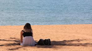
Photo credit above: NOAA.
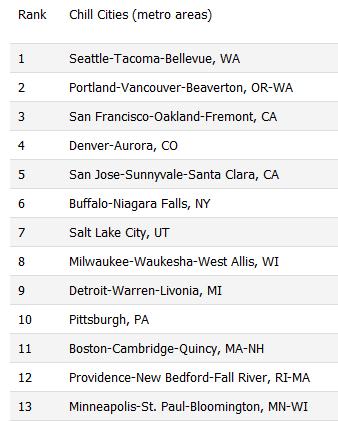
Sperling's Chill Cities. What are the best places in
the U.S. to spend a cool, comfortable summer? We ranked #13 here in the
Twin Cities on this list, which you can see at
bestplaces.net.
Here's an excerpt: "Summer heat and humidity can seem relentless, with
no relief in sight. Even moderately-high temperatures can be
unbearable when combined with high humidity and nighttime temperatures
that refuse to dip. But there are places around the United States which
are reliably cool and comfortable, even during the warmest months –
July and August. I used our new Sperling Heat Index to identify the
places with the desirable combination of moderate daytime temps, low
humidity, and cool temperatures at night. Of the 50 largest metro areas
in the United States, Seattle, Portland and San Francisco have the
most comfortable summers, with mild temperatures, cool nights and
humidity so low it’s barely noticeable. (A full ranking of the 50
largest metros is at the end of this post, plus a ranking of all 361
U.S. metros.)"
National Geographic has more information on where you can cool down, naturally,
here.
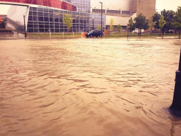
Flash Flooding. Thanks to Andrew Schwisow for
passing along this photo of extensive flash flooding in Columbus, Ohio
Monday morning. July is a favored month for these fickle floods, when
weather systems and embedded T-storms are moving very slowly, capable of
"training echoes", storms redeveloping over the same counties for hours
on end.
Subarctic Wildfires More Active Now Than In Last 10,000 Years.
NBC News has the story - here's an excerpt: "
Subarctic
wildfire frequency is higher now than it has been at any other point in
the last 10,000 years, new records show. The records, obtained from
charcoal in the Yukon Flats of Alaska, have revealed the history of
wildfire activity in the region known as the subarctic, the area just
south of the Arctic Circle, from North America to Scandinavia and
Siberia, where boreal forests dominate and winters are long and dark.
But what the higher frequency of wildfires spells for the subarctic in a
warmer future world is difficult to predict, researchers say..."
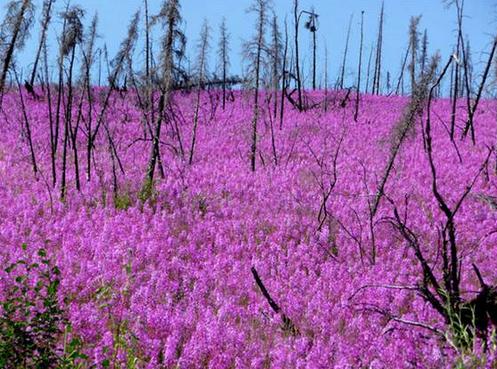
Photo credit above: Feng Sheng Hu. "
Fireweed, which is
bright pink in color, is a plant that often grows after an area has
been burned. Here, fireweed is shown blanketing parts of Alaska's Yukon
Flats, a fire-prone boreal region."
"Ask Paul" Weather-related Q&A:
Hello
"I
read the viewing of Northern Lights are suppose to be really good this
year. Can you tell me where is Minnesota is the best place to view the
Northern Lights? Also, the date (s) and time?
Thank you in advance for your help."
Linda
Linda, I haven't had much luck seeing the Aurora Borealis during the
spring and summer months in Minnesota; the best time to see the
"Northern Lights", at least in my experience, is during the fall,
especially October and November, with longer nights, clear air and a
drop in haze/humidity it seems easier to take in a free show. That is IF
you can get away from the light pollution glow of the Twin Cities. I've
had the best luck at my cabin north of Brainerd. If you drive into the
outlying suburbs, at least 20-30 miles away from the downtowns, you have
a shot, especially on a clear, moonless night. Your best odds? After a
major solar flare, when a display is most likely to take place. The
Northern Lights is otherwise impossible to predict in advance. Here's a
good resource to check on any given day to see if the display may extend
into Minnesota, the
Geophysica Institute, at the University of Alaska, Fairbanks. Good luck!
"Whats Fall weather going to be like.....?"
Thanks Paul!
Jerome and Kim Niss
Jerome and Kim, the short answer is "cooler",
but that doesn't seem very satisfying. In recent years autumns have been
trending longer and milder, in other words we seem to hang onto summer
warmth a little longer than we did 30-40 years ago. There's a chance an
El Nino (warming) phase may return in the Pacific, which correlates with
milder falls and winters across Minnesota. But that just may be wishful
thinking. Back to my original forecast. "Cooler".
What Exactly Is A "Meteo-Tsunami?" This is a new one for me too, but meteorologist Jeff Renner at
KING-TV in Seattle has the answer: "
A
tsunami is a wave generated by seismic events-earthquakes-underwater. A
meteo-tsunami is generated by weather, often big and sudden changes in
air pressure. Meteo-tsunamis are less destructive than seismically
generated tsunamis, though they can still be dangerous...and they don't
just occur along ocean coasts. A 10 foot meteo-tsunami killed 7 people
in Chicago on June 26, 1954." (Photo credit
here).
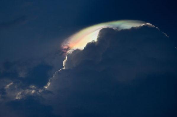
A Rare Look At An Iridescent Cloud. It's fairly common to see these clouds in MInnesota. I thought this was an interesting article, courtesy of
National Geographic - here's a clip: "...
Iridescent
clouds, known as "fire rainbows" or "rainbow clouds," occur when
sunlight diffracts off water droplets in the atmosphere. And the recipe
for these heavenly sights is actually pretty simple. Like common
cloud-to-ground rainbows, iridescent clouds usually accompany
thunderstorms. According to atmospheric phenomena expert Les Cowley,
they often appear in the late afternoon, on very hot and humid days.
This stems from the fact that most rainbow clouds form on top of cumulus
clouds—the fluffy cotton-ball-shaped clouds we often see in children's
drawings..."
Photo credit above: "
This picture of an irridescent cloud was submitted by a National Geographic reader. The photo was taken in Noida, India." Photograph by Harish Venkatesh.
10 Most Expensive Photographs In The World.
Freeyork.org has the story (and photos with pricetags attached). Here's
the intro: "Sometimes photographers amaze us with their art, the ability
to uniquely reflect the world around us and get a look at it from a
different angle. And sometimes doing something completely disgusting or
normal so that it is impossible to understand why the work is
recognised as a masterpiece. Anyway, these photos were sold for
millions of dollars."
Photo credit above: "
#1 Rhein II – Andreas Gursky (1999) $4.3 million."
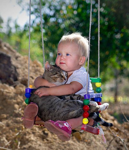
12 Pictures That Will Restore Your Faith In Humanity. Having a rough day? Check out this link from
Citizens Awareness Vanguard.
Photo credit above: "
Two best friends on a swing." Source:
volobuev.me
Nightclub Urinal Tells Patrons When They've Had One Too Many. Now here's some useful technology, courtesy of
gizmag.com: "
Alcohol
and driving definitely don’t mix, but those most in need of having
their keys taken away are the worst judges of how much they've had to
drink. As part of an anti-drink/drive campaign by Singapore’s Zouk
nightclub, DDB Group Singapore developed the Pee Analyzer: a system
fitted to urinals that tests patrons’ alcohol levels every time they
take a trip to the bathroom..."
Climate Stories...
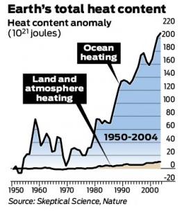
No, Global Warming Hasn't Stopped and Here's Why. An
estimated 90% of warming is going into the world's oceans, not the air.
James Temple has a good explanation of what's really going on at
seattlepi.com; here's a clip: “...
When
skeptics or deniers say look at this little graph that shows that
temperatures are not warming anymore, they’re misleading or misreading
or both,” said Peter Gleick, president of the Pacific Institute, a
research institute in Oakland. Now it is true that some scientists
acknowledge a decline in the rate of temperature increases in recent
years, what some have dubbed the climate change plateau or slowdown.
But nothing about that is particularly reassuring — or gets us off the
hook for our skyrocketing greenhouse gas emissions. First off, consider
the conditions we’ve witnessed during this period. Regardless of the
rate of increase in temperatures, globally nine of the ten hottest
years on record have all occurred since 2000. “It would be absurd to use
the hottest 10 or 15 years on record to argue that we don’t need to
worry about the Earth getting even hotter,” said Ken Caldeira of the Carnegie Institution
in an email. We’re already living with the consequences of climate
change, including more extreme weather events, melting ice caps, rising
sea levels and more..."
Climate Change Slowdown Is Due To Warming Of Deep Oceans, Say Scientists.
The Guardian has the story - here's the introduction: "
A recent slowdown in the upward march of global temperatures is likely to be the result of the slow warming of the deep oceans,
British scientists said on Monday. Oceans are some of the Earth's
biggest absorbers of heat, which can be seen in effects such as sea
level rises, caused by the expansion of large bodies of water as they
warm. The absorption goes on over long periods, as heat from the
surface is gradually circulated to the lower reaches of the seas.
Temperatures around the world have been broadly static over the past
five years, though they were still significantly above historic norms,
and the years from 2000 to 2012 comprise most of the 14 hottest years
ever recorded. The scientists said the evidence still clearly pointed
to a continuation of global warming in the coming decades as greenhouse
gases in the atmosphere contribute to climate change..."
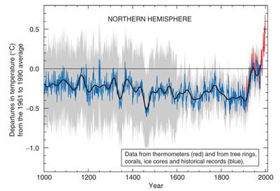
Graphic credit above: "
Temperature in the northern
hemisphere since 1000 CE. Natural variation in the climate cycle does
not contradict climate scientists' predictions." Graph: IPCC report
East Antarctica's Ice Sheet Not As Stable As Thought. ScienceNOW has the story; here's an excerpt: "
Earth
continues to hit temperature and greenhouse gas milestones—just a
couple of months ago, multiple stations measured carbon dioxide
concentrations in the atmosphere of 400 parts per million, the
highest in several million years. Many studies have tried to estimate
how much and how rapidly the two great ice sheets covering
Greenland and Antarctica might melt—and the one reassuring point has
been the apparent relative stability of the eastern (and, by far,
larger) half of the Antarctic Ice Sheet. Now, a new study of past
melting in East Antarctica suggests that over the long haul, the
"stable" ice sheet may be more vulnerable to warming than thought..."
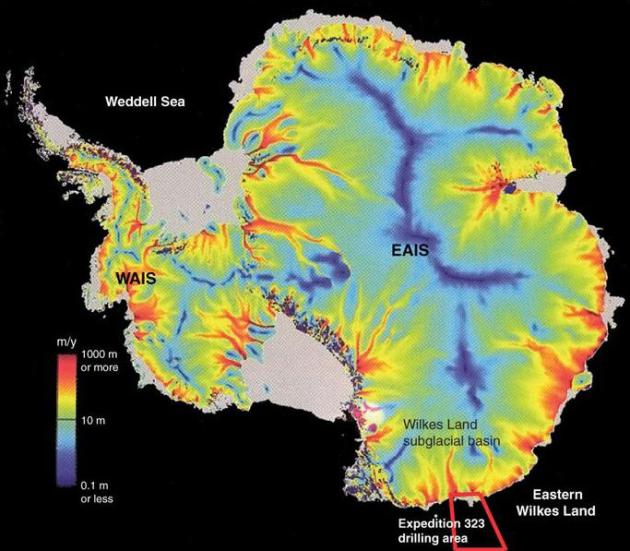
Image credit above: "
Exposed. The East
Antarctic Ice Sheet (EAIS) may be more vulnerable to global warming
than thought. Sediments drilled offshore of the continent's Wilkes Land
Subglacial Basin indicate that the basin was ice-free during parts of
the warm Pliocene Epoch." Credit:
Integrated Ocean Drilling Program
Nuclear's Safety Lesson For Fracking. What steps can be taken to make the extraction of shale gas as safe as possible? Here's an excerpt of an Op-Ed at
The Baltimore Sun: "...
I
believe oil and gas companies could learn some important lessons from
the U.S. nuclear industry, which has made the safe operation of nuclear
plants its most important task. After the Three Mile Island accident
in 1979, the nuclear industry adopted the axiom, "An accident anywhere
is an accident everywhere," reflecting its concern that one major
local accident could derail nuclear power worldwide. It instituted a
strong safety culture, rooted in benchmarking with stringent safety and
performance standards, continuous learning, information sharing among
nuclear companies, and constant training of power-plant operators. To
put all of this into practice, the industry created the Institute of
Nuclear Power Operations (INPO). INPO's inspection teams conduct regular
evaluations of nuclear plants, and it sets industry-wide performance
goals. Last year, in several key areas, U.S. nuclear plants either
matched or improved upon levels of performance from previous years. For
example, there were 62 unplanned automatic or manual reactor
shutdowns, matching a record low set in 2011..."
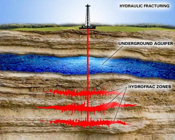
Image credit:
University of Colorado, Boulder.
Climate Change Will Alter The Soil That Feeds Us. Here's the intro to a story from Climate News Network and
Climate Central: "
Global warming may be about to change the ground under our feet –
and perhaps not in a good way. It could be about to affect one of the
most important communities on the planet: the tiny microbes that make
life possible for the rest of creation, according to new research by
scientists in the U.S. and Spain. Cyanobacteria are almost everywhere,
have been around for the whole of life's 3.5 billion history, and fix
nitrogen from the atmosphere to fertilize plants and feed animals..."
Photo credit: "
Soil – of a sort. Changes to microbial life may affect erosion and fertility of the soil we need." Credit: Arman333 via Wikimedia Commons.