Summer Roller Coaster
If you have one foot in ice-water, the other in boiling water, do you feel "average"? Since June 1 both
heating and cooling degree days, a measure of how far we are from 65F, are running above average in the Twin Cities.
How can it be warmer AND cooler? Evidence of
more extremes? A few extra-hot weeks earlier in July coupled with chilly
surges in early June & late July? Yes, this summer has been a
meteorological roller coaster.
"I don't find this apparent paradox unusual.
It's a mathematical quirk stemming from the way heating and cooling
degree days are calculated" Minnesota state climatologist Greg Spoden
said yesterday.
The National Weather Service says last Saturday
brought the coolest July temperature (36F) ever observed in southern
Minnesota at 850 millibars (4,100 feet).
It may be an omen of freakish August cool fronts
to come. ECMWF (European) guidance shows another jab of chilly air
pouring south the second week of August. If this verifies we could see
some 50s up north: metro highs in the 60s.
The jet stream is still misbehaving - something significant has changed.
A cooler front sparks a shower today;
comfortable sun returning Wednesday into Saturday; highs near 80F. An
anemic "warm front", yes.
"...
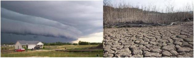
The existence of extreme weather is obvious to Minnesotans. That’s because, according to FEMA
data, nearly 100 percent of us live in counties that have been
affected by at least one federally declared weather-related disaster
since 2007..." - from a Minnpost Op-Ed below.
"...
Strauss says tragedy can be avoided or mitigated with deep
global pollution cuts followed by technology that sucks CO2 from the
atmosphere. Such bold steps, he says, could help preserve hundreds of
coastal communities. If current emissions continue, his analysis
projects the year when global carbon emissions will lock hundreds of
U.S. cities into the eventual sinking — below the high-tide line — of
the land that now houses half their residents: Galveston, Texas (2030);
Miami (2040); Norfolk, Va., (2044); Coral Gables, Fla. (2044); and
Virginia Beach (2054)." - from a USA Today story, details below.
Photo credit: Marvin Nauman, FEMA.
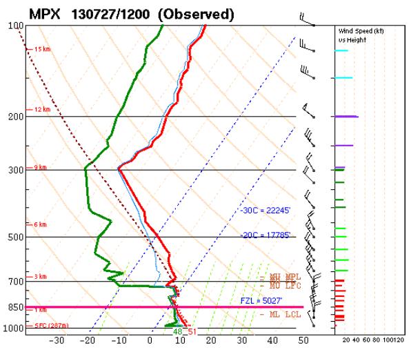
Record Cold 850 mb Temperature. As referenced above, here are more details on last Saturday's historically chilly sounding report from KMPX, courtesy of the
Twin Cities National Weather Service: "
The
12Z MPX sounding launched on the morning of Saturday, July 27th
revealed the coldest temperature ever measured in southern Minnesota at
850 mb (or about 4,100 feet AGL) for the month of July. At only 2.2 C
(36F), it was about 13C cooler than the usual values seen at that level
for this time of year. Believe it or not, it is not unusual to get these
temperatures at 850 mb periodically during the winter. Heat waves
typically consist of 850 mb temperatures in excess of 20 C. Saturday was
a far cry from those values. The 850 mb level is meteorologically
significant for a number of reasons, hence the record keeping..."
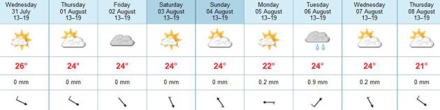
Not A Hot Front In Sight. Well, at least we're
consistent. A/C will remain optional for most of the next week; highs
approaching 80F Friday and Saturday, then cooling off slightly Monday
before a stronger cool front approaches late next week. No soaking rains
or major storms brewing looking out 7-10 days.
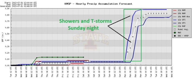
A Dry Spell. In spite of a fleeting shower or
sprinkle this morning, most of the next 96 hours will remain dry; the
best chance of showers and T-storms coming Sunday night. Graphic: Iowa
State.
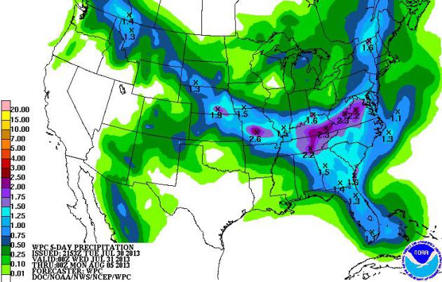
A Persistent Atmospheric Tug Of War. A scuffle
between two airmasses, one overheated and stuffy, the other comfortably
Canadian in origin, will set the stage for heavy showers and T-storms
with some 1-3" rainfall amounts from the Central Plains into the Ohio
Valley and Mid Atlantic region. 5-day rainfall accumulated rainfall
prediction courtesy of NOAA.
Relatively Quiet. The weather usually slows down in
August, and the first week of August, 2013, will be no exception. A
series of weak cool fronts spark showers and T-storms from the Great
Lakes to the East Coast, while the soggy remains of "Dorian" soak the
Bahamas. Monsoon T-storms sprout over the Rockies and Southwest, while
the West Coast remains tinder-dry. 84 hour NAM model loop: NOAA.
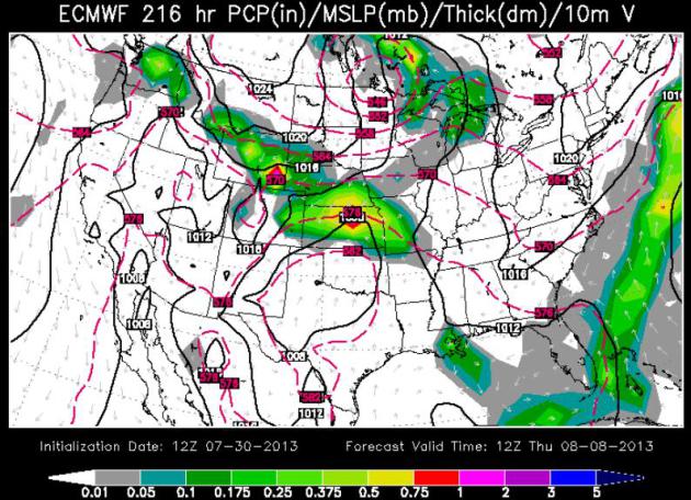
August Sweatshirts? It's too early to say with a
high confidence level, but long-range ECMWF (European) guidance shows
another healthy dose of chilled air pushing south of the border next
Thursday, August 8. If this verifies high temperatures may hold in the
50s up north Thursday, with some gradual moderation in temperature by
the following weekend. Map courtesy of ECMWF.
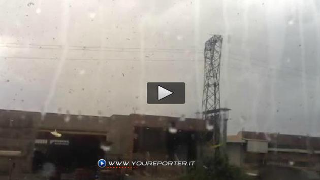
Tornadoes Strike Italy Near Milan - Incredible Video. Here's an amazing clip from
The Washington Post: "Check out this *insane* video from
inside
a tornado near Milan, taken from an office building. Watch as a huge
mass of debris – some of the fragments very large – swirls and then
rages through the air (the action picks up in a big way after about 40
seconds).
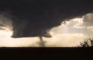
Long-Range Tornado Prediction: Is It Feasible? The short answer appears to be yes, at least in terms of broad trends. Here's an excerpt from a story from
UCAR: "...
The
push to explore extended (two-to-six-week) and seasonal (three-month)
tornado prediction has gained momentum due to several factors.
- Researchers are understanding more clearly how multiyear
cycles such as El Niño and La Niña and the Pacific Decadal Oscillation
influence tornado frequency. For example, when La Niña is transitioning
to El Niño during springtime, the odds of a major tornado
outbreak—especially in the Midwest and South—appear to be almost twice
as large as in neutral springs, according to a recent Journal of Climate paper led by Sang-Ki Lee (University of Miami/NOAA).
- The NOAA Climate Forecast System (CFS) now issues nine-month forecasts of U.S. circulation anomalies four times each day. This makes it a potential foundation for building weekly to seasonal tornado outlooks.
- High-resolution regional models that simulate thunderstorms directly—such as ARW, the NCAR-based Advanced Research Weather Research and Forecasting Model—can now be linked to larger-scale climate models..."
Photo credit above: "
More than 1,000 tornadoes strike the United States in a typical year—sometimes in clusters of more than 50 in a single day." (©UCAR. Photo by Greg Thompson).
NOAA's National Weather Service More Than Doubles Computing Capacity.
Some of this is in response to the European ECMWF model, and how it
out-performed the GFS and other U.S. models, especially during "Sandy"
last year. Encouraging news for those of us who want the USA to have the
fastest (most accurate) computer models on a consistent basis.
Details from NOAA: "
Whizzing through 213 trillion calculations per second, newly upgraded supercomputers of NOAA’s National Weather Service
are now more than twice as fast in processing sophisticated computer
models to provide more accurate forecasts further out in time. And as
the hurricane season ramps up, forecasters will be armed with an
enhanced hurricane model that will improve track and intensity
forecasts. The scientific data and insights that these newly upgraded
supercomputers will provide are essential to help government officials,
communities, and businesses better understand and manage the risks
associated with extreme weather and water events. In support of the
president’s Climate Action Plan, the administration will continue to
take steps like this to analyze and predict climate variability amid an
increasing number of extreme natural events affecting the nation..."
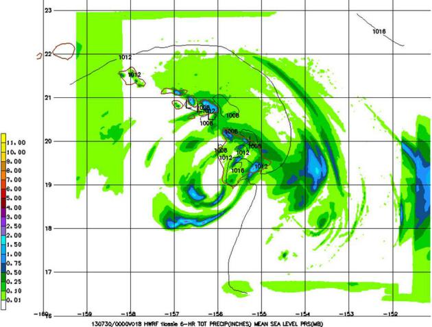
Graphic credit above: "
This is the Hurricane Weather
Research and Forecasting (HWRF) model showing the Tropical Storm
Flossie precipitation forecast for the Hawaiian Islands on July 29,
2013. HWRF is one of the sophisticated numerical computer models now
being run on NOAA's new supercomputers."
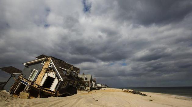
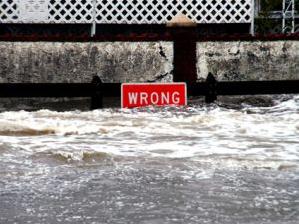
Outrage As Homeowners Prepare For Substantially Higher Flood Insurance Rates.
We're just seeing the tip of the iceberg with this issue. If someone
wants to live on or near the coast, should other Americans, well away
from rising seas, be forced to subsidize their (cheaper) flood
insurance? Some people may walk away from insurance altogether and take
their chances. Here's a clip from
The New York Times: "...
Currently,
the only way to obtain lower rates is to raise a home above certain
elevation levels. That can be difficult in New York, where the housing
stock is old, and homes are often attached to adjacent buildings.
Economists and insurance experts said the program needed to be
overhauled to make it financially viable. “The program is $26 billion in
debt and much of that debt is borne by federal taxpayers who do not
have flood insurance,” said Frank W. Nutter, president of the
Reinsurance Association of America. “They are subsidizing those that do...”
Photo credit above: Lucas Jackson, Reuters.
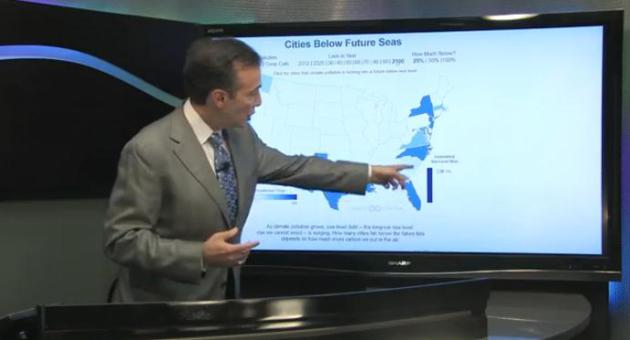
Climate Matters: Warming Air, Rising Seas. For every
1 F. of global temperature increase the world's oceans are forecast to
rise by a little more than 4 feet. Buying beachfront property will
involve even more faith, a strong stomach, and almost limitless wallet
in the years and decades to come. In today's edition of
Climate Matters: "
WeatherNationTV
Chief Meteorologist Paul Douglas looks at how climate change leads to
rising sea levels and what coastal cities can expect to see by 2040.
Also, more on torrential downpours and record setting rainfalls."
Possible Tornado Struck Washington D.C. And The White House 100 Years Ago. Here's a clip from a fascinating read at The Washington Post's
Capital Weather Gang: "
A
hot and humid airmass set the stage for a destructive thunderstorm and
possible tornado that tore through the District 100 years ago today
(July 30, 1913). On the afternoon of July 30, 1913, the temperature in
Washington had surged to 97 degrees for the second straight day. It
was the fourth consecutive day the temperature had exceeded 90. Late
that afternoon, a severe thunderstorm erupted near Washington, D.C. and
it raked the city with violent wind gusts. Its torrential rains
exceeded two inches. The storm resulted in considerable building and
tree damage, particularly in northwest D.C..."
Photo credit above: "
On the White House grounds, there
were 16 trees uprooted and 25 that were damaged during the severe
thunderstorm of July 30, 1913." (Library of Congress).
Life And Death In Assisted Living. If you have a loved one in assisted living, or about to go into assisted living, watch this 53 minute documentary from
PBS Frontline
and ProPublica - an impressive, and sobering bit of journalism. Many
assisted living facilities don't have the staff necessary to deal with
Alzheimers, dementia and serious ailments, and yet the promise of a fat
bottom line is prompting many facilities to fill up as many beds as
possible, even if trained staff is inadequate to handle all those
residents. My mother, who passed away late last year, was in a
particularly good assisted living facility, but I worry about the
patients and families of those who aren't getting the care they need,
deserve, and paid for.
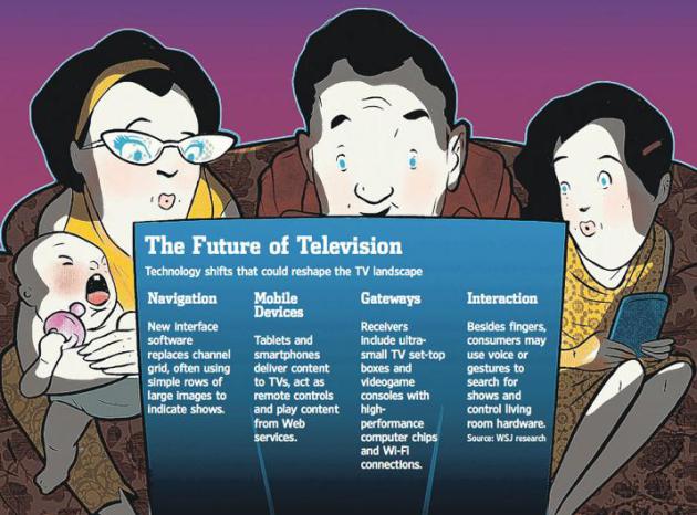
Rethinking How We Watch TV. Aereo and Dish's Hopper
are two (very) disruptive technologies. When you empower consumers the
content gate-keepers become nervous, and a paradigm shift (lead by
Netflix) is changing the way many of us access our favorite shows.
The Wall Street Journal has a story focused on the trends (subscription may be required to read the full article). Here's an excerpt" "...
Computer
industry players have been pushing new TV visions for 20 years, with
decidedly mixed results. Cable and satellite TV providers have strong
positions, with big players like Comcast Corp. CMCSA -1.59%
preparing major technology upgrades of their own. Negotiations with
media companies for content rights could delay new services and limit
some features, though Intel vows to enter some markets by the end of
the year. Yet there is a growing consensus that underlying technologies
are evolving to the point that major changes in the TV experience are
all but inevitable, whether delivered by new entrants or incumbents.
"I've never seen as much innovation in television as there is right
now," says Ulf Ewaldsson, chief technology officer at Swedish
telecom-equipment giant Ericsson, which plans to step up its own TV
efforts..."
Infographic: The Amount Of On-Line Activity That Goes On In 60 Seconds.
This is fascinating, in a "look how I just wasted a minute!" kind of
way. Yes, we like to hear ourselves echoing around in cyberspace.
Details from
designtaxi.com: "To give us an idea on how fast and big the internet truly is,
Qmee has created an infographic that shows us the amount of online activity that goes on every 60 seconds.
According to infographic ‘Online in 60 Seconds’, there are 2
million searches on Google, 72 hours of videos uploaded onto YouTube, 42
thousands post every second and 1.8 million likes on Facebook, and 204
million emails sent every minute.
This 14-Year Old Is Kicking Your (Butt) At Photo Manipulation. OK, I cleaned up the title a little for a family-friendly audience.
Buzzfeed has details: "
Meet
Zev, also known as Fiddleoak. Through his self-portraits, he creates a
wondrous and whimsical world that you’ll wish you lived in."
Photo credit: "
You are blowing my mind Zev." Source:
fiddleoak / via:
fiddleoak.wordpress.com
Oops, Best TV News Bloopers Of July. There are some good ones in here - it's worth a look, courtesy of
tvnewscheck.com.
Climate Stories...
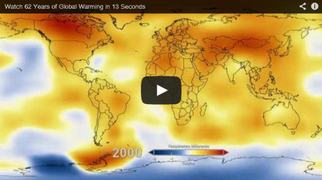
How To Prove To A Global Warming Denier That Climate Change Is Real, In 14 Seconds. This short video clip, courtesy of
The Washington Post, is from NASA.
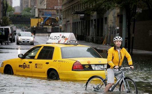
Study: Sea Level Rise Threatens 1,400 U.S. Cities. Here's a clip from a story at
USA Today: "
A
rise in sea levels threatens the viability of more than 1,400 cities
and towns, including Miami, Virginia Beach and Jacksonville, unless
there are deep cuts in heat-trapping greenhouse gas emissions, says an
analysis out Monday. Prior emissions have already locked in 4 feet of
future sea-level rise that will submerge parts of 316 municipalities,
but the timing is unclear and could take hundreds of years, according
to the paper in the Proceedings of the National Academy of Sciences. If
global warming continues at its current rate through the year 2100, at
least an additional 1,100 cities and towns will be mostly under water
at high tide in the distant future..."
Photo credit above: "
A bicyclist
makes his way past a stranded taxi on a flooded New York City street
Aug. 28, 2011, as Tropical Storm Irene passes through the city." (Photo: Peter Morgan, AP).
Climate Study Predicts A Watery Future For New York, Boston And Miami. Following up on the story above, here's a different perspective from The Guardian: "...
Even
if we could just stop global emissions tomorrow on a dime, Fort
Lauderdale, Miami Gardens, Hoboken, New Jersey will be under sea
level," said Benjamin Strauss, a researcher at Climate Central,
and author of the paper. Dramatic cuts in emissions – much greater
than Barack Obama and other world leaders have so far agreed – could
save nearly 1,000 of those towns, by averting the sea-level rise, the
study found. "Hundreds of American cities are already locked into
watery futures and we are growing that group very rapidly," Strauss
said. "We are locking in hundreds more as we continue to emit carbon
into the atmosphere." A recent study, also published in PNAS by the climate scientist Anders Levermann found each 1C rise in atmospheric warming would lead eventually to 2.3m of sea-level rise.
The latest study takes those figures, and factors in the current rate
of carbon emissions, as well as the best estimate of global temperature
sensitivity to pollution..."
Photo credit: Brett Brownell, Mother Jones.
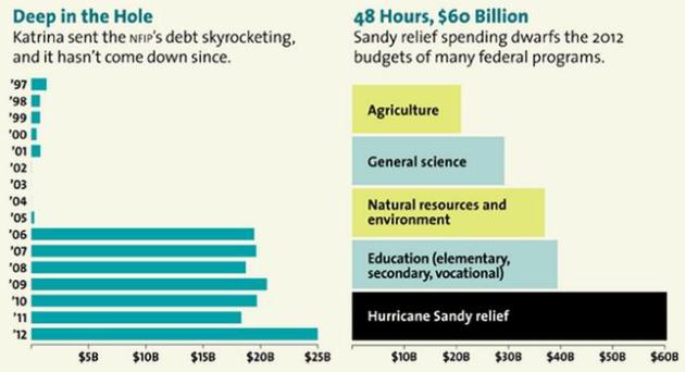
The High Cost Of Climate Inaction. Here's an excerpt from
treehugger.com and Mother Jones that caught my eye: "
Climate change is already creating major economic problems for businesses. But Kate Sheppard has a must-read
in the latest Mother Jones on the immense costs to the federal
government due to the shortsightedness of paying huge sums in annual
disaster relief, while doing almost nothing to prepare for the
inevitable next storm. Sheppard writes: Roughly 123 million of us—39
percent of the US population—dwell in coastal counties. And that spells
trouble: 50 percent of the nation's shorelines, 11,200 miles in all,
are highly vulnerable to sea level rise, according to the National
Oceanic and Atmospheric Administration. And the problem isn't so much
that the surf laps a few inches higher: It's what happens to all that
extra water during a storm. We're already getting a taste of what this
will mean. Hurricane Sandy is expected to cost the federal government
$60 billion. Over the past three years, 10 other storms have each
caused more than $1 billion in damage. In 2011, the federal government
declared a record 99 weather-related major disasters, from hurricanes
to wildfires. The United States averaged 56 such disasters per year
from 2000 to 2010, and a mere 18 a year in the 1960s.."
Global Warming: Urgent With A Chance Of Optimism. Here's a snippet of an Op-Ed from Environment America's Madeline Page, at
Minnpost.com: "
In
terms of weather, this summer — even in all of its storm-induced power
outage glory — has not been particularly noteworthy; that’s probably
because it pales in comparison to the weather antics of 2012. However,
as a heat wave scorched a huge swath of the country in mid-July,
especially in the Midwest, I was reminded of what’s in store if we
continue to act sluggishly in solving our current climate-change
trajectory. The existence of extreme weather is obvious to Minnesotans.
That’s because, according to FEMA
data, nearly 100 percent of us live in counties that have been
affected by at least one federally declared weather-related disaster
since 2007. Last year alone, we witnessed the devastating consequences
of unchecked carbon pollution through climate-associated weather events
like Hurricane Sandy and devastating droughts here in the Midwest..."
Photo credit above: REUTERS/Pascal Rossignol. "
The bottom
line is that global warming is fueling the extreme weather that we've
witnessed, and it will only become more frequent and severe unless we
act."
Climate Change Divestment Plans Go On The Offensive.
The Guardian has the story - here's a clip: "
Bill McKibben, leader of the global climate action group 350.org, had barely left Australia when the Climate Commission released its report The Critical Decade 2013.
The timely report underlines much that we already know. The climate is
changing and the evidence continues to strengthen. The risks we were
warned about are now happening. The effects of climate change
endangers our "health, property, infrastructure, agriculture and
natural ecosystems". More needs to be done to stabilise the climate. And
most importantly, "most of the available fossil fuels cannot be burnt if we are to stabilise the climate this century"...
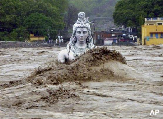
Climate Change's Nasty New Natural Disaster: "Himalayan Tsunamis". GlobalPost has the story - here's the introduction: "
This summer’s devastating “Himalayan tsunami” is
a grim omen for the future of the millions of people living downstream
from the majestic mountain range. The June floods wiped out the Hindu
pilgrimage town of Kedarnath and may have killed as many as 6,000 people.
But the scale of the disaster could be dwarfed by future flooding,
experts warn. “The Kedarnath floods may be only a small precursor to
never-seen-before mega floods,” Maharaj K. Pandit, director of Delhi
University's Center for Inter-disciplinary Studies of Mountain &
Hill Environments, told India Today...." (Photo credit: AP).