Healthy Paranoia
Want to live to see great grandchildren? Eat
your vegetables - and don't push the weather. One of the meteorologists I
work with was just traumatized by lightning up in the Boundary Waters.
"There was nowhere to go" she said.
Trying to stay safe while camping in a
thunderstorm is challenging. High winds can topple trees onto tents, and
shy of retreating to your vehicle, there often isn't a good place to
ride out severe lightning. A central restroom facility offers some
degree of protection.
Remember to wait at least 30 minutes after the
last thunderclap before resuming outdoor activities on a lake or beach.
You may not get a cell signal to check your favorite radar app in the
North Woods, but always have an escape route, a viable Plan B.
Yesterday's storms are long gone; a northwest
breeze pumps comfortable, Canadian air into Minnesota today as dew
points dip into the 50s under blue sky. More T-storms return over the
weekend; a few may be severe.
It's still unclear whether Tropical Storm Chantal will impact the Southeast early next week; updates on the blog below.
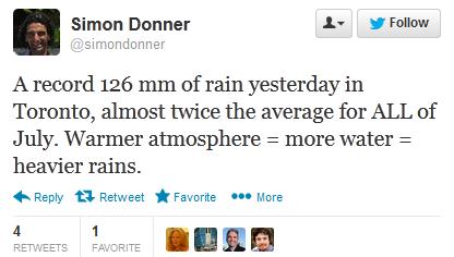
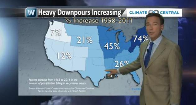
A warmer atmosphere means more water vapor to fuel storms. Toronto picked up 2 month's worth of rain late Monday.
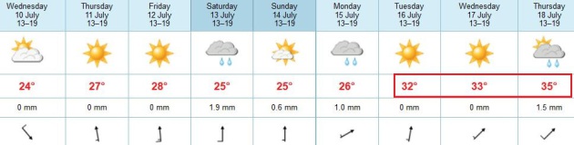
Seasonably Warm - Seriously Hot Next Week? After a
spell of 80s into the weekend there are signs we may really heat up next
week; 90s likely by the middle of next week, a 1 in 3 shot at 100F heat
next Thursday, based on ECMWF guidance.
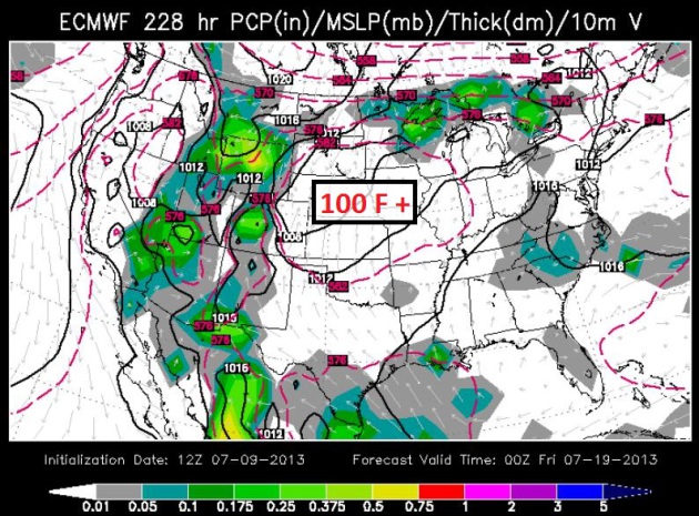
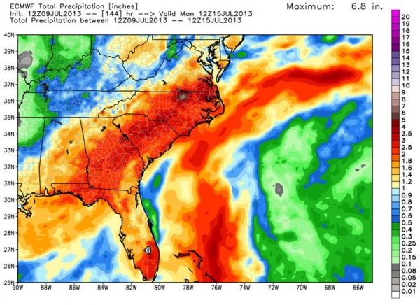
July Heatwave Central USA. It's early, but guidance
is strongly hinting at a period of 95 to 105F heat by the middle of next
week over the nation's midsection. Highs may approach 100 from Omaha
and Kansas City to the Twin Cities and Chicago. ECMWF guidance above is
valid next Thursday evening, courtesy of WSI.
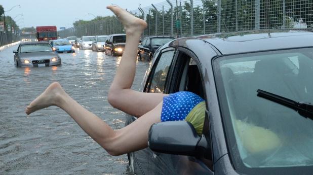
Dramatic Photos Show Parts Of Toronto Underwater.
The Toronto metro area saw record rains Monday evening, as much as 5" of
rain, most of that falling in 2-3 hours. Some suburbs picked up two
month's worth of rain in a summer evening, turning roads into rivers,
flooding out the subway system, creating nightmare commutes. Photo above
courtesy of
CTV News, which has more photos and tweets from the record flash flood: "
A woman gets gets back in her car in flood water on Lakeshore West during a storm in Toronto on Monday, July 8, 2013." (Frank Gunn / THE CANADIAN PRESS).
Toronto Flood Event: Continuing A Trend Of More Extreme Rains.
It's the atmospheric version of The Lotto: which community is going to
be next to see a 1 in 500 or 1 in 1,000 year flood event? Monday evening
it was Toronto's turn. Here's a recap in today's edition of
Climate Matters: "
A
freak flood event in Toronto, Canada's largest city, shut down the
subways, stranded commuters and cut off power to 300,000 customers.
Chief Meteorologist Paul Douglas has more on Toronto's record rainfall
as well as extreme recent rains in the Eastern U.S. Plus a quick update
on Tropical Storm Chantal which could bring more moisture to the
Southeast U.S."
All-Time Rainfall Records:
- Most in one minute: 38 mm (1.5 in); Barot, Guadeloupe, 26 November 1970.[118]
- Most in one hour: 305 mm (12.0 in) in 42 minutes. Holt, Missouri, United States, 22 June 1947.[42]
- Most in 12 hours: 1,144 mm (45.0 in); Foc-Foc, Réunion, 8 January 1966, during tropical cyclone Denise.[42]
- Most in 24 hours: 1,825 mm (71.9 in); Foc-Foc, Réunion, 7–8 January 1966, during tropical cyclone Denise.[42]
- Most in 48 hours: 2,467 mm (97.1 in); Aurère, Réunion, 8–10 January 1958.[42]
- Most in 72 hours: 3,929 mm (154.7 in); Commerson, Réunion, 24–26 February 2007.[42]
- Most in 96 hours: 4,869 mm (191.7 in); Commerson, Réunion, 24–27 February 2007.[42]
- Most in one year: 26,470 mm (1,042 in); Cherrapunji, India, 1860–1861.[42]
- Highest average annual total: 11,872 mm (467.4 in); Mawsynram, India.[42]
File photo above: Reuters.
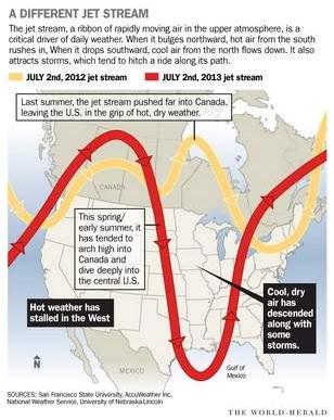
Don't Get Too Comfortable: Extremes Like Last Year's Heat Wave Are Expected To Recur. Here's an excerpt of an informative article from
omaha.com: "...
While
extreme variability is a normal part of weather, emerging research is
knitting together an explanation of why these extremes are becoming
worse. One of the things that ties recent years together is a jet
stream that loops more steeply than it typically has, resulting in
stalled weather patterns that allow conditions to intensify. The jet
stream matters because it separates cold Arctic air from warm tropical
air, and it serves as the highway that most storms ride along. As the
jet stream drops south, cold air flows into the U.S. As it shifts
north, warm air fills in behind it. After the jet stream bypasses a
region, less rain or snow falls. Robert Oglesby, a climate scientist
and professor at the University of Nebraska-Lincoln, points to the jet
stream to explain the past few years. “Our weather appears to be
exactly the opposite of last year, but the two years have a lot in
common,” Oglesby said. The common denominator: The jet stream has been
traveling an exaggerated wavy path. In scientific terms, it's called
amplified circulation..."
Hurricane Forecasting Remains A Challenge.
Especially predicting storm intensity. Track outlooks continue to slowly
improve, but our worst fear, as meteorologists, is going to bed with a
Category 1 hurricane, only to wake up the next morning to a Category
4. Here's an excerpt of a story at
The Sun Herald in Mobile, Alabama: "
We're
due for a big one, some say. Every year now since 2004 and 2005 --
the years of Hurricanes Ivan, Dennis and Katrina -- the Gulf Coast has
been "due" for a storm season worse than the year before. Now, one
month into the official hurricane season, forecasters expect a
double-digit number of storms to develop. As many as 13 to 20 named
systems -- storms with 39 mph winds or higher -- are estimated for the
coast by the National Oceanic Atmospheric Administration this year.
Three to six of those may be major hurricanes, categories three or
higher. If those numbers sound familiar, that's because weather
experts have been predicting more active weather patterns since the
mid-1990s, says Bill Williams, director of the Coastal Research Center
at the University of South Alabama..."
From an
Alerts Broadcaster Update that went out Tuesday afternoon:
Latest on Tropical Storm Chantal:
* The storm continues to strengthen slowly; maximum sustained winds are now 65 mph with higher gusts.
* Chantal is forecast to track just south of the U.S. Virgin Islands
and Puerto Rico, hitting Haiti and The Dominican Republic as a strong
tropical storm within 36 hours.
* Some computer models strengthen Chantal to a Category 1 hurricane over the Bahamas by late week.
* It's early, but the most likely track is into the Carolina coast by Sunday or Monday.
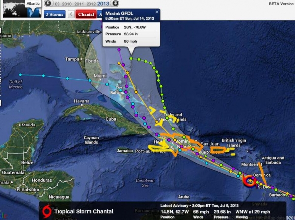
Chantal Fix. Chantal is packing 60-65 mph winds;
it's not inconceivable that Chantal may strengthen to hurricane status
before sweeping into Hispaniola (Haiti, Dominican Republic) Wednesday
PM hours, where rainfall amounts may be extreme. Some 5-15" rainfall
totals may result in serious flooding for Port au Prince and the higher
terrain of The Dominican Republic. The GFDL model solution (above)
shows 86 mph sustained winds by Sunday morning just north of the
Bahamas. Graphic courtesy of
Ham Weather.
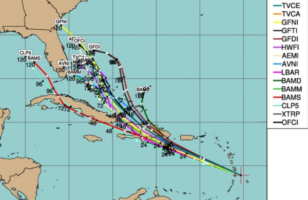
Projected Track. The models are all in fairly good
alignment until Chantal crosses Hispaniola and pushes into The Bahamas.
Florida may experience heavy rains from Chantal, even if it takes an
eventual turn toward the Carolina Coast. Facilities from Miami to Palm
Beach and Jacksonville should be on alert for late week and the
weekend.
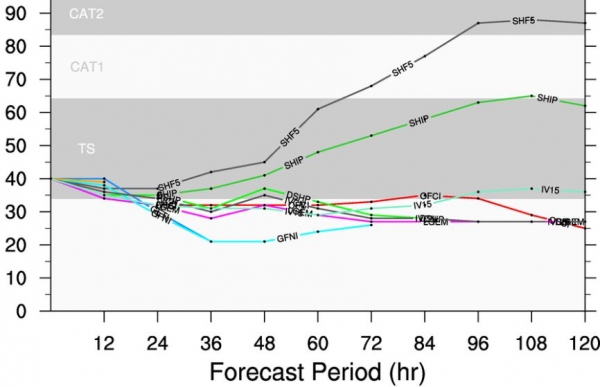
Intensity Prediction. Most models keep Chantal as a
tropical storm looking out 96 hours, through roughly Saturday morning.
But some intensification is now expected over the weekend as the
center of Chantal passes over the warm, open waters of the Bahamas. As
it pushes north of Haiti it may strengthen into a Category 1 hurricane,
in fact a few of the models (above) are hinting at Category 2 strength
by Sunday PM hours. Again, confidence levels are low, but facilities
from the Bahamas to the Atlantic coastline of Florida, Georgia and the
Carolinas should remain vigilant and be prepared to initiate Hurricane
Action Plans within 48-72 hours.
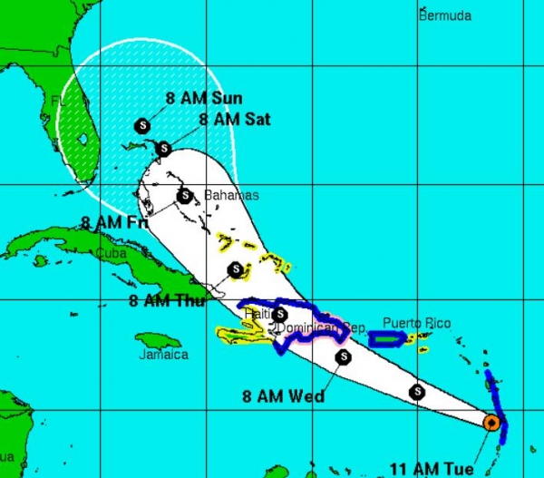
Timing Chantal. The greatest threat of storm surge
waves (5-8 feet above normal) and excessive inland rains over Haiti and
The Dominican Republic should comes Wednesday night. Chantal is
forecast to reach the Bahamas late Friday into Saturday; a few of the
models showing the storm stalling out near Freeport this weekend.
Image: NHC.
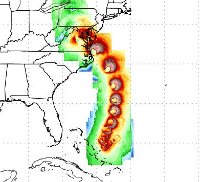
Predicted Rainfall By Monday. ECMWF (European) data
shows the heaviest rain bands from Chantal's soggy remains from near
Augusta to Charlotte and Raleigh, where some 2-5" amounts are possible.
Again, it's premature to project precisely where the heaviest rain
bands will set up from Chantal, but odds (slightly) favor eventual
landfall over the Carolinas by Sunday or Monday. Image: Weather Bell.
GFDL Track. NOAA's high-resolution GFDL model shows
a possible landfall from Chantal near Wilmington, North Carolina by
Sunday night or Monday of next week. Confidence levels are low:
Chantal's moisture may impact a wide swath of real estate from coastal
Florida to the Bahamas and Carolinas. This track will almost certainly
change as new data arrives - it's important to stay vigilant and
prepare staff and facilities for any eventuality.
Summary: Chantal is becoming better organized,
presently a strong tropical storm packing 60-65 mph. winds, heading for
Haiti and The Dominican Republic by late tomorrow. Some weakening is
likely as the storm interacts with mountainous terrain of Hispaniola,
but many of the models now show strengthening by late week, possibly to
hurricane status as Chantal reaches The Bahamas by Friday and early
Saturday. From there the track and intensity prediction is very
tenuous, but there's still a better than 50-50 chance that Chantal will
impact the Southeast USA coastline by Sunday or Monday, either as a
tropical storm or hurricane. Every tropical system is different, unique
- and Chantal is not giving any obvious cues about track or intensity
once it reaches the Bahamas within 72-96 hours. We'll keep an eye on
the storm and keep you posted.
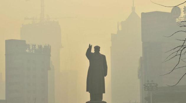
Pollution In Northern China Has Shaved Residents' Life Expectancy By An Average Of 5.5 Years.
If you've been to Beijing or Shanghai lately you won't find this story
hard to believe. This is what happens when you don't have the equivalent
of an EPA, when "market forces" trump all.
Quartz has the story; here's an excerpt: "
In 1999, Shanghai’s mayor at the time visited Beijing and, noticing the smog, said,
“If I worked in your Beijing, I would shorten my life at least five
years.” His comment turned out to be not just prescient but weirdly
precise. According to a new study, air pollution in northern China has
shortened life expectancy by an average of 5.5 years. The study (pdf)
by researchers at Massachusetts Institute of Technology and Tsinghua
University, finds that smog in China shaved off a total of 2.5 billion
years of life expectancy of about 500 million people in the 1990s. The
study is one of the few attempts to measure the long-term health effects
of China’s pollution, as well as one of most comprehensive data sets
compiled on mortality and air pollution in China. Another study this year found that pollution may have caused 1.2 million premature Chinese deaths in 2010..."
Photo credit above: "
Not quite the China that Mao envisioned." Reuters / Sheng Li
Why So Many Flood Maps Are Still Out Of Date. Here's an excerpt of an interesting read from
Propublica: "
The
Federal Emergency Management Agency’s flood insurance maps are
critically important for millions of Americans who live in flood-prone
areas. The maps determine the annual premiums for flood insurance,
which is required by law for homeowners with federally backed mortgages
who live in high-risk areas. But many of the nation’s flood maps are
woefully out of date. ProPublica talked with David R. Maidment, a
professor at the University of Texas at Austin who has advised FEMA on
flood mapping, about why the data behind modern maps is 10 times as
accurate as the older data and why half of Texas still doesn’t have
up-to-date maps..."
Smartphones Used To Predict Earthquakes. Here's the intro to a story at
The Telegraph: "
The
prototype app uses the accelerometer present in the devices to act as a
basic seismometer, which is used to detect the vibrations from
earthquakes. Developed by a team from the Californian Institute of
Technology (Caltech), CrowdShake bypasses the need for external
plug-ins. Many residents of the Pasadena community, a small city within
Los Angeles, currently use small seismometers plugged into their PCs
or routers to detect tremors. One challenge the team faces in the use
of smartphones as detection agents is differentiating between
earthquake vibrations and normal movement..." (Photo: AP).
Your Flip Flops Are Grossing Me Out. There's a place
for flip flops, no doubt, but have you noticed more people relying on
these vaguely unsightly, unsanitary forms of footwear? One writer for
Huffington Post has had enough: "
Some
slow week in summer, I should write a tirade against flip-flops,” I
unwisely remarked to my editor one disgusting August afternoon a few
years back, as we walked back from lunch behind a woman whose
street-blackened soles could be glimpsed anew with each schlapp!-ing
step. Now, during an early-July lull between big summer movie releases,
he’s gone and called my bluff. And the truth is, I’m not really one for
composing tirades. I’m a live-and-let-live sort when it comes to
personal grooming and style, and whatever qualities I’m remembered for
at my funeral, I’m fairly certain neither hygiene nor chic will top the
list. But the increasing prevalence of all-day urban flip-flop wear
during the summer months is something we need to talk about as a
culture..."
Photo credit above: "
The bane of society." Photo by William Philpott/Reuters.

Climate Stories....
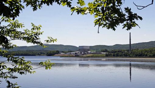
Climate Change To Strain Water Supply Used By Power Plants: Study.
Between cooling power plants and enabling fracking operations, a lot of
fresh water is going to be diverted in the months and years ahead. Mark
my words: water, not oil or gas, will quickly become the most precious
natural resource of the 21st century, worldwide. Here's a clip from a
story at
The Sydney Morning Herald: "
Waterways
warmed by climate change will increase electricity prices by as much
as a third in southern Europe as producers struggle to cool power
stations, a study showed. Countries from Romania to Bulgaria and
Slovenia face the biggest price increases, according to research today
from the Laxenburg, Austria-based Institute for International Applied
Systems Analysis. Dutch, German and Spanish scientists participated in
the study. “The combination of increased water temperatures and reduced
summer river flow under climate change is likely to affect both
hydropower and thermoelectric power generating capacity in Europe,”
wrote the authors, led by Michelle van Vliet, whose research focuses on
how warming climate will affect world river flows..."
Photo credit above: "
In this June 19, 2013 photo, the Vermont Yankee nuclear power plant sits along the banks of the Connecticut River in Vernon, Vt." (AP Photo/Toby Talbot)
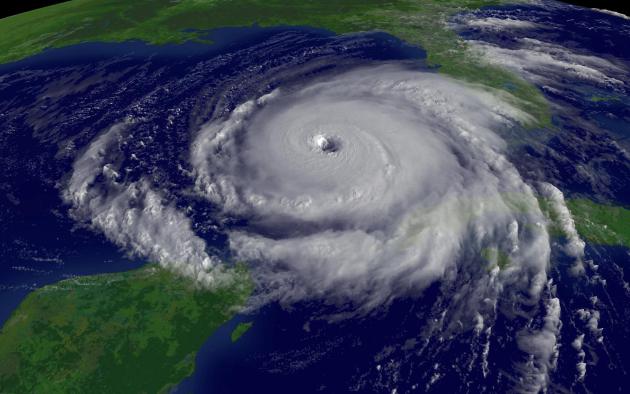
Hurricanes Likely To Get Stronger And More Frequent: Study. Meteorologist Andrew Freedman has the story at
Climate Central; here's an excerpt: "...
With
the population of coastal areas growing daily and sea level on the
rise, how these monster storms may change as the climate continues to
warm is an increasingly urgent question facing climate scientists,
insurance companies, and public officials. A new study by Kerry
Emanuel, a prominent hurricane researcher at MIT, found that contrary
to previous findings, tropical cyclones are likely to become both
stronger and more frequent in the years to come, especially in the
western North Pacific, where storms can devastate the heavily populated
coastlines of Asian nations. Emanuel's research showed the same holds
true for the North Atlantic, where about 12 percent of the world's
tropical cyclones spin each year. Emanuel's study casts doubt on what
had been the consensus view of most climate scientists — that in most
ocean basins, tropical cyclones are likely to become less frequent as
the world warms, but that the storms that do occur are likely to
contain stronger winds and heavier rains..."
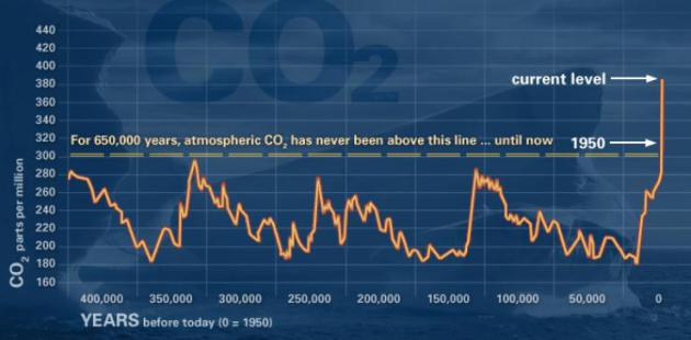
Climate Change: How Do We Know? Here's an explanation of the graph above, from a
NASA web site focused on the overwhelming amount of evidence surrounding climate change: "
This
graph, based on the comparison of atmospheric samples contained in
ice cores and more recent direct measurements, provides evidence that
atmospheric CO2 has increased since the Industrial Revolution." (Source:
NOAA)
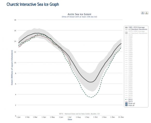
Arctic Sea Ice Melt Speeds Up. Here's the intro to a story from Minnesota climate scientist Greg Laden at
scienceblogs.com: "
Earlier
in the northern summer, it looked like the rapid melt of Arctic Sea
ice we’ve been seeing over the last several years was happening again,
but rather than being a record year, it was merely tracking along the
lower side of the distribution of the long term average. Last year,
in contrast, the amount of sea ice hit an all time low early in the
year and then broke previous records into tiny icy pieces. One of the
reasons last year’s ice melt was so dramatic is that an early storm
churned up the ice and got melting going a bit early. This year, there
was no early churning up event, but over the last several days of June
and beginning of July, the rate of sea ice melt has suddenly increased
dramatically and this year’s track is looking like it may come close
to catching up to the previous year’s unprecedented extreme..."
State Department Admits It Doesn't Know Keystone XL's Exact Route. Say what?
DeSmogBlog has the details; here's the intro: "
The
State Department's decision to hand over control to the oil industry
to evaluate its own environmental performance on the proposed Keystone
XL tar sands pipeline has led to a colossal oversight. Neither
Secretary of State John Kerry nor President Barack Obama could tell
you the exact route that the pipeline would travel through countless
neighborhoods, farms, waterways and scenic areas between Alberta's tar
sands and oil refineries...."
How To Talk To Your Parents About Climate Change.
It's been interesting seeing the evolution in thought with my father, an
uber-conservative. Lately he's been taking a closer look at the data,
and peer-reviewed research, and he's pretty much reached the same
conclusion that most reach when they actually dig into the science:
somethat has, in fact, changed, and our release of greenhouse gases is
probably impacting climate (and weather events). Here's an excerpt from
Huffington Post: "
Maybe it will turn out that human intelligence won't be favored by selection, and we'll soon grow ourselves into oblivion.
But no matter what our eventual fate, I think it would do our souls
good to at least try to slow down our self-destruction. After all, just
because a penchant for murder and Kardashians seem to be inherent
human flaws doesn't mean we shouldn't do our best to minimize them. I
don't expect public opinion on climate change will be swayed by
columnists and pundits preaching to their choirs. Those who want to
ignore the vast scientific evidence
on the subject have likely already skipped to the comment section
below to try to convince you that since I'm not shouting these things
naked from a wooden hut in the middle of a bog, I'm a hypocrite and
deserve to be ignored. For those still reading, I have a suggestion.
Most of us don't have millions of dollars to go toe-to-toe with the
disinformation campaign being waged by the oil and gas industry. But
most of us do have living parents. So let's talk to them about climate
change. Because if we can't convince the people who love us more than
anything in the world to take action on climate, who can we convince?..."