Limits of Technology
We don't know as much as we think we do.
Technology is a useful tool, but it's still far from foolproof,
especially going up against Mother Nature, who tends to get the last
laugh.
On May 31 an erratic EF-5 tornado suddenly
veered northeast, killing 3 experienced tornado researchers. Earlier
this week sudden, violent winds triggered by pop-up T-storms fanned the
Yarnell Hills blaze, trapping 19 heroic firefighters.
Thunderstorms can do more bad than good out
west, capable of "dry lightning": no rain reaches the ground, but
lightning can ignite new flames. Fickle winds at the base of these
storms can make it impossible to predict where the fire line will
advance next.
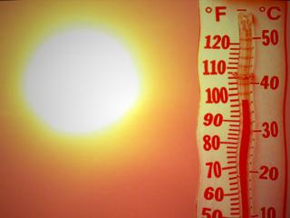
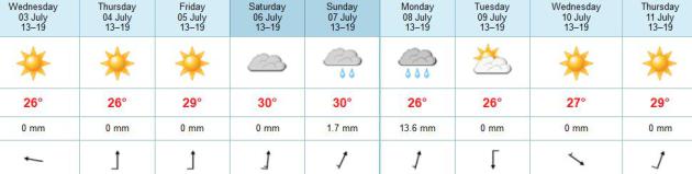
Some of the best weather America has to offer
will be floating above our heads in the coming days, a stubborn ridge of
high pressure blessing us with 80s, blue sky, and reasonable humidity
levels. A retrograding (east to west moving) storm over the Ohio Valley
may spark late-day storms over Wisconsin & Iowa, but most of us
won't see T-storms until Sunday. Weekend highs approach 90F with a
drippy dew point of 70. It will feel like summer this weekend.
After the year we've had I guess we've EARNED a memorable 4th.
Photo credits. Upper left: KFOR-TV, Oklahoma City. Upper right: azfamily.com.
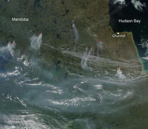
NASA Image: Fires In Manitoba. This is why we've had
such a hazy, milky-white sky (and cherry-red sunsets) in recent days.
Smoke from fires up north is being swept south of the border. According
to an
article at phys.org 27 separate fires in Manitoba have burned over 300,000 acres.
Image credit above: "NASA image courtesy Jeff Schmaltz, MODIS Rapid Response Team."
 Sunny Streak Continues
. The ECMWF
is
fairly consistent; with the first chance of T-storms (in the metro)
coming on Sunday - possibly late Saturday up north. Highs reach the
upper 80s to near 90 by Saturday and Sunday. Monday still looks like the
wettest day with the best chance of T-storms, as a slow-moving cool
front tracks across the state.
 Not Quite Right For Early July.
By now a massive heat-pump high pressure ridge should be dominating
most of the USA as the jet stream lifts north into Canada. Not so in
2013, with unusually big, sweeping, north-south dips and bulges to the
jet. In fact weather systems have pretty much stalled, in fact the band
of showers and heavy T-storms sweeping from the Gulf of Mexico right up
the Appalachians is retrograding, drifting toward the west!
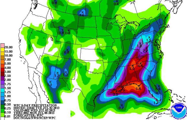 Soggy Fourth For The Southeast
.
NOAA's 5-Day QPF shows 5-6" rainfall amounts from the Florida Panhandle
to near Huntsville, Atlanta and Asheville, where more flash flooding is
possible by the weekend. No rain is forecast for the west coast or the
Central Plains into early next week.
4th of July Weather Since 1871: Fairly Good Odds Of Dry Weather. At least that's been the case in recent years. Farther back in weather history? Not so much. Here's an excerpt from the
Minnesota State Climate Office: "
Looking
back at records dating to 1873 for the Twin Cities, the average high
and average low for Independence Day are 82.4 degrees F and average low
of 62.6, respectively. 2012 came in as the warmest July 4th on record
at 101 degrees, this was a part of an extremely warm early July.
1967 recorded the lowest high temperature at 58 degrees, which was the
last time the high temperature has dipped below 70 degrees. Although
recent July 4th's tend to have warm and mostly dry, Mark Seely mentions
on the June 28th 2013 WeatherTalk
that it is the rainiest holiday in Minnesota looking back to 1891.
The heaviest rainfall occurred in 1900, a year that saw 2.27 inches of
rain over Independence day. The most recent washout occured in 1995,
the Twin Cities reported 0.24 inches from 6:00-8:00 PM, with a brief
shower at Noon. This has been the lone rain event to disrupt July 4th
events in the Twin Cities for the past 50 years..."
Image credit above: Twin Cities National Weather Service.
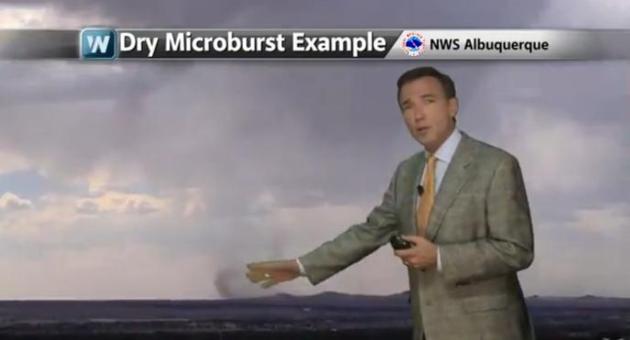
"Dry Lightning", Sudden Wind Shifts and Haboobs. You
would think that a forecast of thunderstorms for the Southwest would be
greeted as good news. Not necessarily. A sudden wind shift (gust
front) from rapidly moving thunderstorms in Arizona probably fanned (and
shifted) the flames that ultimately claimed the lives of 19
firefighters northwest of Phoenix. And when the atmosphere is so dry
T-storms can spark lightning, with little or no rain actually reaching
the ground. A mixed blessing at best, unless it rains hard and
repeatedly for days on end. Here is today's installment of
Climate Matters: "
You
might think a thunderstorm would be good news for firefighting efforts
because it brings much wanted moisture. Think again. Not all
thunderstorms bring rain. WeatherNation Chief Meteorologist Paul
Douglas explains how a storm can be dry and why this creates extremely
dangerous conditions for those battling wildfires."
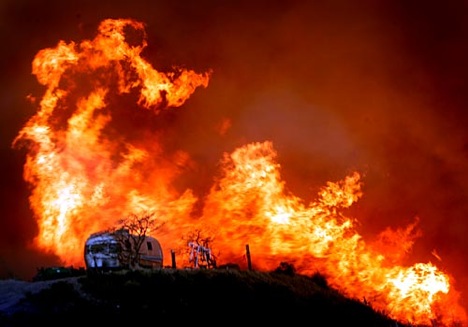
In The Line Of Wildfire. 19 highly skilled,
fire-fighting "hotshots" just lost their lives battling a blaze 80 miles
northwest of Phoenix. Who are these men, and how do they take on raging
fires with backpacks and shovels?
Outside Magazine published an article on June 13 detailing what life is like on the front lines: "
I
ROLL OUT of my sleeping bag at 5 A.M., waking to the smell of dry
grass and woodsmoke. I spent last night in the open, camped on rodeo
grounds in the tiny Northern California town of Stonyford. Flames are
visible on a ridge half a mile away. Time to go to work. It’s July 12,
2012, and I’m about to be sent to my first forest fire of the season. I
arrived yesterday to meet up with the Tahoe Hotshots,
an elite group of wilderness fire-fighters based about 120 miles east
of here, in a Sierra foothills town called Camptonville. The Tahoe team
is part of a sprawling, multifaceted army: 177 federal, state, and
county crews who must try and stop a fast-moving, 17,000-acre blaze
before it spreads into Stonyford. Known as the Mill Fire, it was started
on July 7 by lost hikers and raced east through the Coast Range and
the Mendocino National Forest.
Drought conditions and 60-mile-per-hour Pacific winds have fueled its
advance; already, five buildings have burned on the edge of town...."
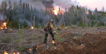
Photo credit above: "
Tahoe Hotshot Isaiah Eastlng burning slash in the Tahoe National Forest."
Photo: Kyle Dickman.
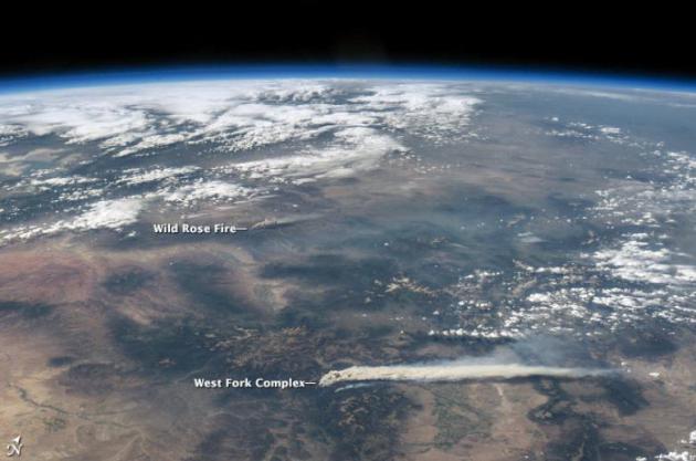
Astronaut View Of Fires In Colorado. Here's a slightly different perspective, one which brings home the scale of these massive wildfires. Here's more from
NASA's Earth Observatory: "
Thick
smoke billows across the landscape in these digital photographs of the
western United States. Both photographs were taken by astronauts
aboard the International Space Station (ISS) on June 19, 2013. The
images show a plume wafting from the West Fork Complex fire, which was burning explosively in southwestern Colorado near Pagosa Springs. To the northwest, a smaller plume from the Wild Rose
fire is also visible (upper image). While the Wild Rose blaze was fully
contained by June 25, 2013, the West Fork Complex was still raging
through the San Juan and Rio Grande National Forests. The West Fork
Complex is a combination of three fires: the West Fork fire, the Windy
Pass fire, and the Papoose fire. Lightning ignited the first of the
blazes on June 5, 2013, and together they had charred approximately
75,000 acres (30,000 hectares) by June 25. The fires were burning in
rugged terrain with large amounts of beetle-killed spruce forests..."
There are currently 27
fires in the northeast section of Manitoba. These fires have burned
over 126,000 hectares (over 311,000 acres). Showers have lowered
wildfire danger levels in most areas of the province with the exception
of northeastern Manitoba where conditions continue to remain dry.
Read more at:
http://phys.org/news/2013-07-nasa-image-manitoba-canada.html#jCp
There are currently 27
fires in the northeast section of Manitoba. These fires have burned
over 126,000 hectares (over 311,000 acres). Showers have lowered
wildfire danger levels in most areas of the province with the exception
of northeastern Manitoba where conditions continue to remain dry.
Read more at:
http://phys.org/news/2013-07-nasa-image-manitoba-canada.html#jCp. Here are some interesting facts from AP and
The Washington Post: "...“
Nighttime
heat is especially bad,” said Eli Jacks, chief of fire and public
weather services at the National Weather Service. “Not to get below 90
is crazy.”
Q: What’s so dangerous about that?
If you aren’t in an air-conditioned place, “your body never has a
chance to recover” at night, Jacks said. Normally the “feels-like”
index — which factors in temperature and humidity — has to get to 80
degrees or below for your body to recover from the daytime heat, Jacks
said. The lack of nighttime cooling is more dangerous than the 117
degree all-time record in Las Vegas, experts said..."
658 people fall victim to intense heat in the USA
every year, according to the CDC, The Center for Disease Control and
Prevention. Heat is, by far, America's biggest weather-related killer.
Heat Waves Throughout History. As always,
perspective is in order - heat claimed far more lives in previous
centuries, long before central air conditioning revolutionized how most
of us ride out a hot summer. I had no idea a heat wave in 1896 killed an
estimated 1,300 New Yorkers. Here's an excerpt of a fascinating read at
history.com: "
Summer
2013 has only just begun, but one region is already feeling the heat.
This week, thanks to an unusual change in direction of the jet stream,
much of Alaska is experiencing near-record breaking temperatures (30
degrees warmer than usual in some places), prompting authorities to
issue warnings meant to protect citizens and prevent the outbreak of
wildfires. As North America prepares for a long, hot summer, find out
what happens when things start to really heat up with this look back at
some of the most infamous heat waves in history..."
With Weather Warnings, How People Use Their Lead Time Is Key. Here's an excerpt from a thoughtful Op-Ed at
The Oklahoman: "...
Weather
science is steadily evolving and vastly improved. In a state so
devastated by violent weather, it's good that so much weather research
is centered here. But government researchers can't dictate how TV
weather teams conduct themselves. Just as we were reminded on May 20 of
the importance of having adequate shelter to weather the most powerful
tornadoes, we were reminded on May 31 that being in cars or storm
drains is deadly. We learned some things from both storms. What did the
TV weather teams learn? How will they change their methods as a result?
What people do in response to a warning is sometimes more important
than how much lead time they have."
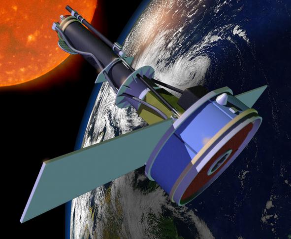
NASA Launches IRIS Solar Mission To Research Space Weather.
Because one of these days we're going to see a G4 or G5 rated X-class
flare that will threaten America's power grid. Hopefully no time soon.
TechHive has the story; here's a snippet: "
NASA
launched a solar telescope on Thursday that scientists hope will be
able to unlock the secrets of how material gathers, moves and heats up
as it travels through the Sun’s lower atmosphere. Scientists say that
better understanding of this part of the solar atmosphere, which sits
below the corona, could help explain and model phenomena like the
ejection of solar material—something that can cause damage to
electronic circuits, power distribution networks and communications
systems on Earth when it gets large enough..."
* more details on the NASA IRIS mission
here.
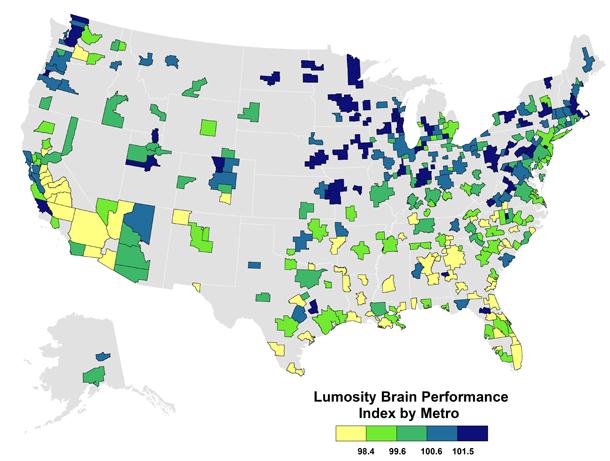
America's "Brainiest" Cities? Not my term, but I found this story in
The Atlantic Cities interesting, and how they came up with their final metrics. Here's the intro: "
In the knowledge age, "smart" cities and metros have a considerable economic advantage. Economists like Harvard's Edward Glaeser
have shown how urban and regional economic growth turn on education
levels or so-called "human capital" (measured by the share of adults who
hold college degrees). Others show the connections between knowledge
and creative jobs, innovation, and economic growth. Still others focus
on the role of specific skills — knowledge, social, and physical — in
economic and urban development (a subject I covered back in October 2011
for The Atlantic.) But what about more direct measures of "brain performance"? Last year, I mapped
America's "brainiest" metros, using new measures and rankings
developed by Lumos Labs via their online brain-performance program, Lumosity. Since Lumosity allows you to track your performance, you can actually see if you're improving or backsliding..."
Map credit above: "
The map above shows the pattern for
metros; the list below shows the top 25 brainiest CBSAs based on
Lumosity rankings. Ithaca, New York, takes first place, followed by
State College, Pennsylvania, and Lafayette-West Lafayette, Indiana, in
third; Iowa City, Iowa, is fourth, and Ames, Iowa, is fifth."
Climate Stories....
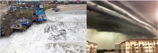
This Is What Climate Change Looks Like: Top 10 Most Expensive Climate Disasters of 2012. Here's a story from
Huffington Post
that provides some perspective, more examples of how a warmer, wetter
climate is fueling more extreme storms - and consequences: "
On Tuesday President Obama released his climate action plan
-- and not a moment too soon. Extreme weather has been pounding the
U.S., and while pundits and the fossil fuel industry will claim action
is too expensive, the cost of inaction is far too much to bear. In 2012
there were 11 climate disasters that cost more than $1 billion each,
according to NOAA. Below are the 10 most expensive.
1. Hurricane Sandy - cost $65.7 billion and caused 159 deaths
Hurricane Sandy touched down on U.S. soil on October 29 after
leaving a path of destruction through Jamaica, Haiti, the Dominican
Republic, Cuba, the Bahamas, and Bermuda. Sandy was the
second-costliest and deadliest hurricane ever to hit the U.S. after
Hurricane Katrina in 2005. A total of 24 states were affected, with
thousands of homes destroyed and millions of people left without
electricity. Of the direct deaths, the storm caused 48 direct deaths
and 87 additional indirect deaths."
Photo credit upper left:
EPA/MASTER SGT. MARK OLSEN / US AIR FORCE
Photo credit upper right:
NWS Meteorologist Samuel Shea
The Climate Context Behind The Deadly Arizona Wildfire.
Climate Central
meteorologist Andrew Freedman takes a look at the trends increasing the
potential for catastrophic blazes out west; here's an excerpt: "...
Thunderstorms
near the fire are a suspected cause of the erratic behavior of the
flames on Sunday, when the firefighting crew was forced to deploy their
last-resort fire shelters to try to deflect the flames. The Yarnell Hill
fire, like other wildfires in the West right now, is taking place in
the context of one of the most extreme heat waves
on record in the region, as well as a long-running drought. While the
contributors to specific fires are varied and include natural weather
and climate variability as well as human factors, such as arson, a draft federal climate report
released in January found that manmade climate change, along with
other factors, has already increased the overall risk of wildfires in
the Southwest. And projections shows that the West may be in for more
large wildfires in the future. Climate models show an alarming increase
in large wildfires in the West in coming years, as spring snowpack melts
earlier, summer temperatures increase, and droughts occur more
frequently or with greater severity..."
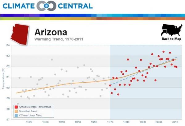
Graphic credit above: "
Statewide temperature trends in Arizona since 1920, with the post 1970 trend line drawn as well." Credit: Climate Central.
Yes, Wildfires Are Connected To Climate Change. Here's How. Treehugger
takes a look at how the combination of less winter snowcover, less
spring rain, a growing drought, and a warming/drying climate, are all
conspiring to create a potentially record summer and autumn for
wildfires out west; here's an excerpt: "...Felicity Barringer and Kenneth Chang at The New York Times
report that scientists are calling this a "new normal" for the American
west: Warmer winters mean less snowfall. More of the winter
precipitation falls as rain, which quickly flows away in streams
instead of seeping deep underground. The soils then dry out earlier and
more quickly in May and June. “It’s the most arid time of year,” Dr.
Garfin said. “It’s windy as well.” The growing season also starts
earlier, so there is more to burn. “The fire season has lengthened
substantially, by two months, over the last 30 years,” said Craig D.
Allen, a research ecologist at the United States Geological Survey
station at Bandelier National Monument in New Mexico..." (Photo: DNR).
Wildland Firefighting At The Rough Cutting Edge of Climate Change. Rick Piltz connects the dots at
Climate Science Watch; here's the intro: "
Western
firefighters are more often encountering conditions they have never
before experienced, with extreme fire behavior and extreme weather
conditions," writes former U.S. Forest Service firefighter Nick
Sundt. “Many of our elected representatives in Washington are napping on
the fireline. They need to wake up and smell the smoke.” The following
is a guest post by Nick Sundt, a former U.S. Forest Service
firefighter, who worked as a hotshot, smokejumper and helitack crew
member from 1976 to 1990: Late Sunday (30 June), 19 firefighters died in
the Yarnell Hill Fire southwest
of Prescott Arizona. All of them were members of the Granite Mountain
Interagency Hotshot Crew; a hotshot crew consists of 20 firefighters,
so nearly the entire crew was killed..."
"Long-Term Perspective On Wildfires In The Western USA". Here
is a paper at the National Academy of Science that delves into
causation. Climate change is a big factor, but probably not the only
variable involved.
Climate Change, Pipelines And Alberta Floods. Here's an excerpt of an article at The Vancouver Sun: "Most
Canadians sympathize with those affected by the Alberta floods, and
many have offered support of various kinds. At the same time, a number
of commentators have pointed out the connection between the oilsands
projects in Alberta, and the sad irony of the flooding relatively
nearby. It has been asserted that intense floods of this nature are
consistent with predictions about climate change, and that the oilsands
are a significant contributor to global warming. While a single event
cannot be used to provide evidence for or against climate change,
scientific models predict that global warming will lead to more intense
flooding in some places (as is currently happening in Alberta), more
intense droughts in others (like in the south of the U.S. for example),
more intense hurricanes (such as exemplified by Hurricane Sandy last
fall on the Atlantic coast), melting of the polar ice caps (as is
happening in the Canadian Arctic) and a variety of other negative
outcomes (possibly including contributing to the severity of tornadoes,
such as in Oklahoma recently)..."
Photo credit above: "
The recent flood in southern Alberta
is consistent with predictions that climate change is causing extreme
weather events, UBC professor writes." Photograph by: Jordan Verlage, The Canadian Press , Vancouver Sun
Oh Canada. How America's Friendly Northern Neighbor Become a Rogue, Reckless Petrostate. Here's the intro to a story at
Foreign Policy: "
For
decades, the world has thought of Canada as America's friendly northern
neighbor -- a responsible, earnest, if somewhat boring, land of hockey
fans and single-payer health care. On the big issues, it has long played
the global Boy Scout, reliably providing moral leadership on everything
from ozone protection to land-mine eradication to gay rights. The late
novelist Douglas Adams once quipped that if the United States often behaved like a belligerent teenage boy,
Canada was an intelligent woman in her mid-30s. Basically, Canada has
been the United States -- not as it is, but as it should be..."
 The Amazing Energy Race
. Here's an excerpt of an Op-Ed from St. Louis Park's Thomas Friedman, writing for
The New York Times: ....“
In
reducing coal’s historic dominance, the president is formalizing a
market trend that was already taking shape,” remarked Andy Karsner, who
was an assistant secretary of energy in the last Bush administration.
His bigger message, though, was “no matter where you find yourself on
the political spectrum, it’s useful for the nation to discuss, debate
and consider a strategy for climate change. The consequences of inaction
are potentially greater than all the other noise out there.” Sadly,
many Republican “leaders” rejected Obama’s initiative, claiming it
would cost jobs. Really? Marvin Odum, the president of the Shell Oil
Company, told me in an interview that phasing out coal for cleaner
natural gas — and shifting more transport, such as big trucks and ships,
to natural gas instead of diesel — “is a no-brainer, no-lose, net-win
that you can’t fight with a straight face...”