Canadian Leakage
Stare at the weather maps long enough and you
begin to hallucinate. I've been telling you (ad nauseum) for years that
something has changed on the maps - the pattern isn't even close to what
I grew up with in the 70s and early 80s. Weather getting "stuck" for
extended periods of time. Odd gyrations in the jet stream steering
winds.
John Mason at Skeptical Science writes:
"Evidence is mounting to indicate that the response of the jet stream to
polar amplification has been to tend to slow down and meander more,
with a greater tendency to develop blocking patterns, which in turn
prolong and intensify all sorts of extreme weather events."
Northern latitudes are warming faster than mid
latitudes, resulting in a 12 percent drop in average jet stream winds,
which may slowing storms and hot high pressure ridges.
All or nothing? Drought or flood?
Speaking of sweeping north-south sweeps in the
jet stream - an early taste of September will keep us in the 60s today; a
ragged, windblown sky and a PM instability shower. Although cool for
the lake temperatures slowly mellow over the weekend; Sunday the nicer
day with more sun & less wind.
A 90s rerun? Not until the second week of August.
The record cool high temp for today in
MSP is 68 F, set in 1903 & 1972. The same stat on the 27th is 65 F, set in 1991.
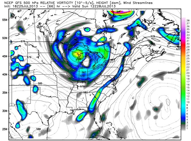
A Buckling Jet Stream. The map above shows predicted
500 mb winds (18,000 feet) at 12z Sunday morning, showing a massive
cut-off low centered north of Green Bay, a swirl of unusually cold air
aloft hovering over the Upper Midwest and Great Lakes. Typical for early
October, not late July. The maps just keep getting stranger. Map
credit: Weather Bell.
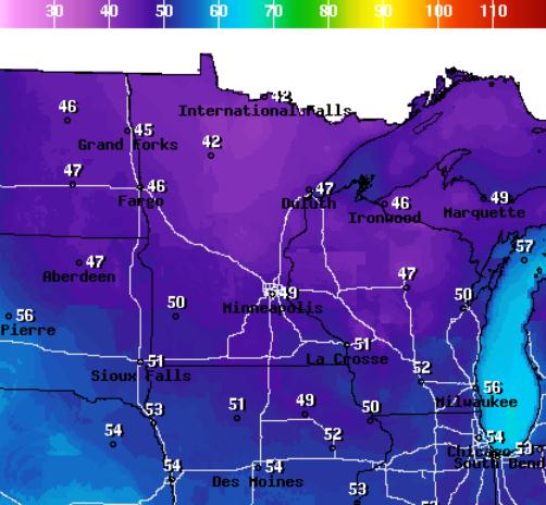
30s Up North Saturday Night? Good grief - what next?
One more symptom of an amped up jet stream taking some very unusual
turns, more evidence of "Arctic amplification". The map above shows
predicted lows for Saturday night, upper 40s in the Twin Cities, low 40s
from Brainerd to Bemidji. I'd bet a bagel Tower and Embarrass will
record lows in the 30s early Sunday morning. Map courtesy of
NOAA.
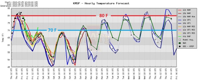
Stunted Thermometers. Nothing more refreshing than a
July cold front huh? Daytime highs hold in the 60s today and Saturday,
reaching low to mid 70s Sunday, a rerun of 80+ highs the latter half of
next week. No, summer isn't over. This is halftime.
Free A/C Into Early Next Week. Highs, even in the
metro, hold in the upper 60s today and Saturday, about 15F cooler than
average for late July. Temperatures slowly recover next week, 80s
returning by late week. Yes, we will see 80s again. A few instability
showers are possible this afternoon (best chance north/east of MSP) and
then it stays dry until next Tuesday and Wednesday, when a few T-storms
may pop ahead of a warmer front.
Summer Relapse. Residents from Minnesota to Michigan
will be reaching for sweatshirts the next couple of mornings, lows
dipping into the 40s and 50s with a stiff wind and a few instability
showers. Meanwhile a tight little storm chugs up the East Coast,
brushing Cape Cod and Boston with heavy rain. Showers and T-storms track
across the Mid South, a few monsoon storms over the Southwest, while
the West Coast remains bone dry. 84 hour NAM: NOAA.
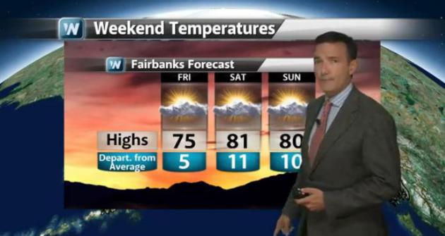
Thawing Out....In Fairbanks. Another mixed-up,
upside-down weather map. Fairbanks will be 20-25 degrees warmer than
much of Wisconsin and northern Michigan by Saturday, a southward dip in a
buckling jet stream plunging an airmass that would be right at home in
late September into the Upper Midwest and Great Lakes. Free A/C? Plenty
of free A/C. Details of today's
Climate Matters: "
Travel
to Alaska to warm-up? Yes,a big change in the jet stream is bringing
much cooler temperatures to the lower 48. Chief Meteorologist Paul
Douglas likes to call it Canadian Leakage. Then there's Tropical Storm
Dorian. The models are all over the place for where Dorian could wind
up."
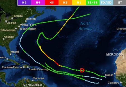
Late July Hurricane Climatology. I thought this was an interesting nugget, courtesy of Brian McNoldy, at
The Capital Weather Gang: "...
In
the past 162 years, just three other storms were named (tropical storm
intensity or greater) this far east during the entire month of July:
Anna 1969, Alex 1998, and Bertha 2008. Dorian has joined that list,
and for reference, its current location is marked with a red “D”…
basically right on top of Bertha’s track; however, Dorian is not
expected to curve out to sea so quickly..."
Image credit above: "
The only three storms that were at least tropical storms at or near Dorian’s longitude during July going back to 1851." (NOAA).
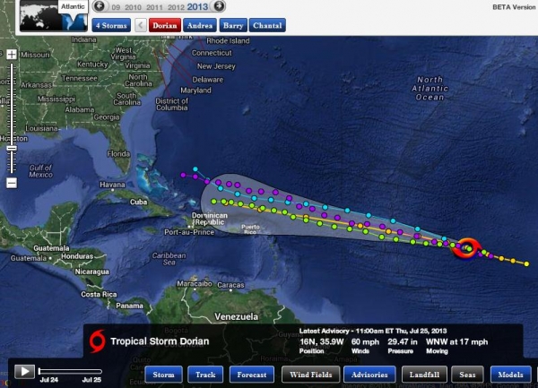
Tropical Storm Dorian Update from Alerts Broadcaster (issued Thursday afternoon):
Here's the latest on Dorian:
* 60 mph sustained winds; Dorian has showed slow but steady strengthening over the last 24 hours.
* Dorian forecast by most models to track north of Lesser
Antilles, U.S. Virgin Islands and Puerto Rico in a Sunday-Monday
timeframe, possibly reaching the Bahamas by Tuesday of next week.
* Model skill levels and confidence are (very) low for
any track/intensity beyond next Tuesday. Dorian may still impact the
USA, but it's too still too early to provide specifics.
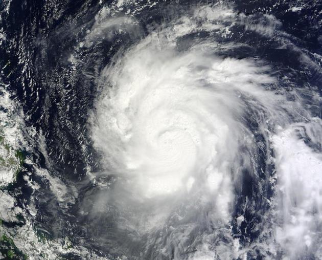
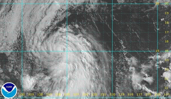
Still Strengthening.
Midday satellite images confirm that Dorian has become a strong
tropical storm, with sustained winds of 60 mph. Ocean water temperatures
are forecast to warm as Dorian heads west-northwest, but wind shear may
still prevent it from reaching hurricane status.
Latest Fix.
Dorian is one of the strongest storms to form so early, and so far east
in the Atlantic. That doesn't necessarily mean a quantifiably higher
risk to the USA, but we need to keep an eye on the storm and see if
future models converge on a believable solution (with moderate to high
confidence). To date that is not the case.
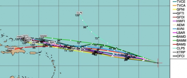
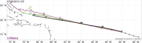
Short-Term Track.
Models are in good agreement, a tight cluster of predicted tracks
taking Dorian on a slightly northward path, one that takes the strongest
winds, heaviest rains and highest storm surge north of St. Martin, St.
John's and San Juan by Monday of next week.
Model Consensus.
Both existing and experimental tropical models have nudged Dorian's
track about 50-100 miles farther north since midday Wednesday.
Confidence levels are moderate to high that Puerto Rico and The U.S.
Virgin Islands will avoid a direct hit.
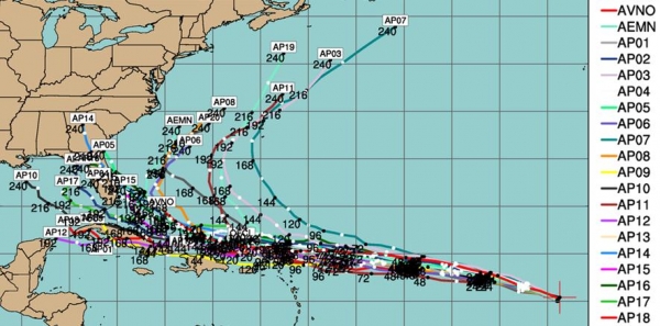
Extended Track.
Various ensemble GFS runs show a wide divergence beyond next Monday;
several models bringing Dorian into the Gulf of Mexico and Florida,
while about a third of the models recurve the storm out into the North
Atlantic. There is a moderate confidence level (6 on a scale from 1 to
10) that Dorian will impact The Bahamas in a Monday-Tuesday timeframe
next week, either as a tropical storm or hurricane. Beyond that we can't
say with any skill or confidence.
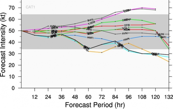
Intensity: Status Quo.
The vast majority of the weather simulations we trust show Dorian
continuing to track west-northwest as a moderate to strong tropical
storm out through 120 hours, only a couple of models strengthen the
storm to hurricane status. Conditions aren't favorable for rapid
intensification through the weekend.
Summary: Although
the final track of Dorian is very much up in the air, we need to treat
this storm (like all Atlantic storms) with a fair amount of respect. History shows that the storms during the first half of the season are the ones that wreak the most havoc.
Out of 74 hurricane names "retired" by NOAA NHC - 59 were the A-K
storms, only 15 the K-Z storms. A high-amplitude pattern (big
north/south gyrations in the jet stream) might be able to pull any
tropical system in the Gulf of Mexico or Bahamas unusually far north
next week, depending on timing, so we all need to pay attention in the
days ahead. We're looking for model trends, continuity and consistency -
the signal amidst the noise of the long-range weather simulations.
We'll keep you posted on the trends and potential for Dorian to reach
the U.S. coastline.
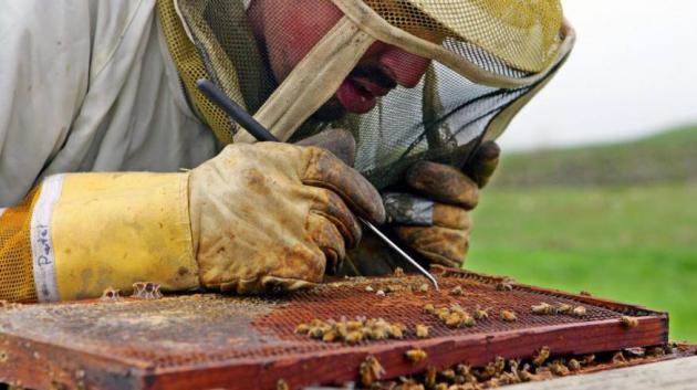
Scientists Discover What's Killing The Bees And It's Worse Than You Thought. Here's more from
Quartz: "
As
we’ve written before, the mysterious mass die-off of honey bees that
pollinate $30 billion worth of crops in the US has so decimated
America’s apis mellifera population that one bad winter could leave fields fallow.
Now, a new study has pinpointed some of the probable causes of bee
deaths and the rather scary results show that averting beemageddon will
be much more difficult than previously thought. Scientists had
struggled to find the trigger for so-called Colony Collapse Disorder
(CCD) that has wiped out an estimated 10 million beehives, worth $2
billion, over the past six years. Suspects have included pesticides,
disease-bearing parasites and poor nutrition. But in a first-of-its-kind
study published today in the journal PLOS ONE,
scientists at the University of Maryland and the US Department of
Agriculture have identified a witch’s brew of pesticides and fungicides
contaminating pollen that bees collect to feed their hives..."
Photo credit above: "
Outlawing a type of insecticides is not a panacea." AP Photo/Ben Margot
The Lucky-Take-All Society. How much of success is true skill, vs. great timing (or luck).
The Economist takes a look in this fascinating article; here's the introduction: "
EVEN
those disturbed by rising income inequality accept the necessity of a
system that rewards ability. And even the most die hard capitalist
would not defend a system that apportions its rewards principally to
the lucky. But what if talent and luck are increasingly hard to
distinguish? Alan Krueger, the departing chairman of Barack Obama’s
Council of Economic Advisers, hit upon just that possibility in a speech
in June, when he observed, “The lucky and the talented – and it is
often hard to tell the difference – have been doing better and better,
while the vast majority has struggled to keep up...” (Photo credit: Alamy).
Climate Stories...
Summer Cyclone Chewing Up Canada's Arctic Sea Ice. Curious how the perpetual, predictable climate deniers will spin this one.
CTV News has the troubling story; here's the intro: "
Arctic
scientists are watching in awe this week as a raging summer cyclone
tears up what could become a record amount of rotting northern sea ice.
"We're really watching this year with a lot of fascination," said
Matthew Asplin, an Arctic climatologist at the University of Manitoba.
Arctic cyclones are driven by low-pressure systems in which winds of up
to 100 km/h blow counter-clockwise in spiral more than 1,000 kilometres
across. They occur in both winter and summer, but are usually stronger
in winter. Cyclones are not unusual in the Arctic, but seem to be
changing in recent years, said David Barber, one of Canada's top
sea-ice experts. "These cyclones are not getting more frequent, but they
are getting deeper -- which means stronger," he said..."
Animation credit:
30 Day Arctic ice animation. United States Naval Research Laboratory, Stennis Space Center, Mississippi.
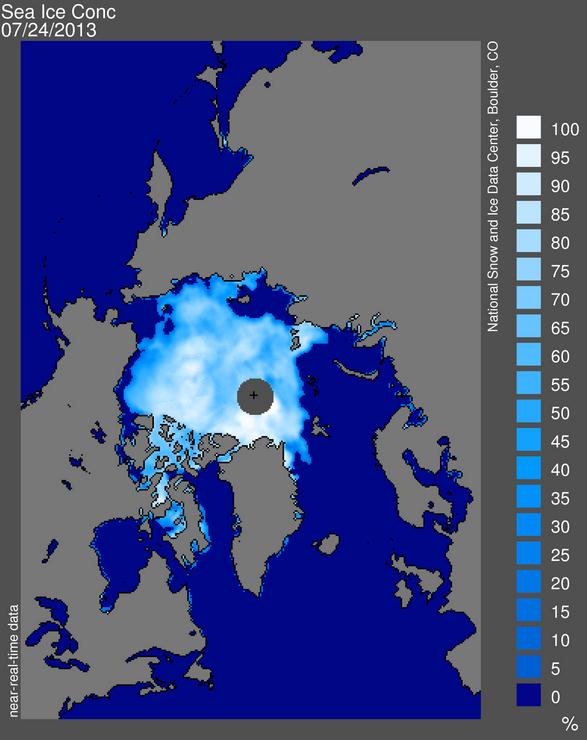
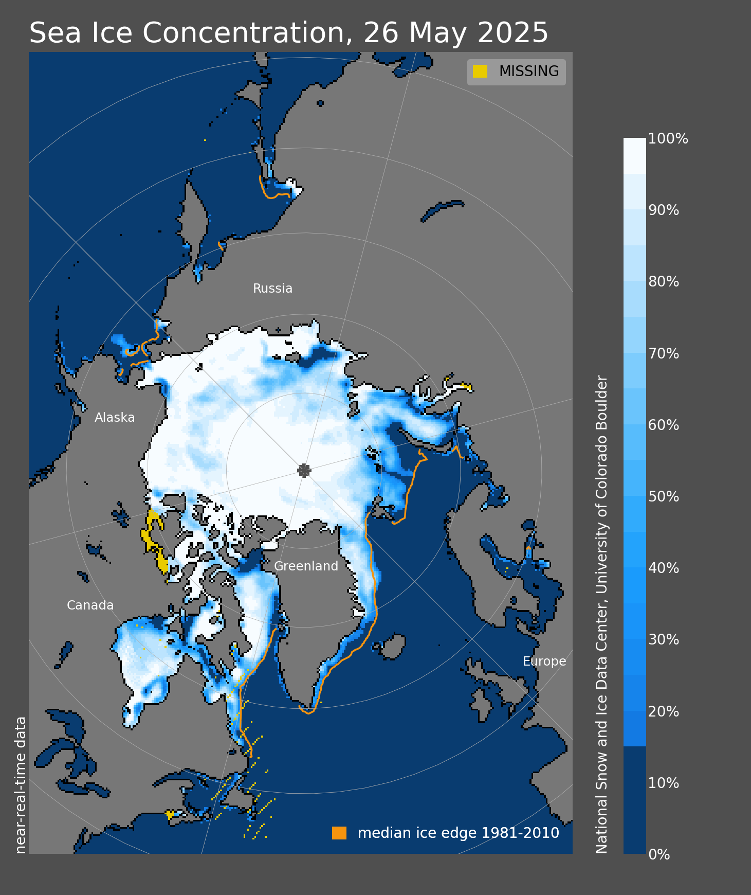
Shrinking Polar Ice Cap.
Sea Ice Concentration map courtesy of the Snow and Ice Data Center.
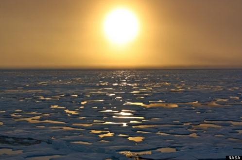
Arctic Methane "Time Bomb" Could Have Huge Economic Costs.
The BBC has the story; here's an excerpt: "
Scientists
say that the release of large amounts of methane from thawing
permafrost in the Arctic could have huge economic impacts for the
world. The researchers estimate that the climate effects of the release
of this gas could cost $60 trillion (£39 trillion), roughly the size
of the global economy in 2012. The impacts are most likely to be felt in
developing countries they say. The research has been published in the
journal Nature..." (Photo credit: NASA).
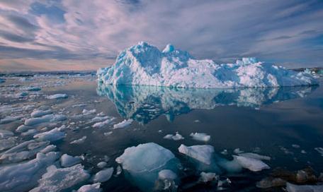
Ice-Free Arctic In Two Years Heralds Methane Catastrophe.
A tipping point in the climate system? There's increasingly little
doubt that we are sailing into uncharted waters, new waters opening up
at the top fo the world. Here's a clip from
The Guardian: "
A new paper in the journal Nature argues that the release of a 50 Gigatonne (Gt) methane pulse from thawing Arctic
permafrost could destabilise the climate system and trigger costs as
high as the value of the entire world's GDP. The East Siberian Arctic
Shelf's (ESAS) reservoir of methane gas hydrates could be released
slowly over 50 years or "catastrophically fast" in a matter of decades –
if not even one decade – the researchers said. Not everyone agrees
that the paper's scenario of a catastrophic and imminent methane
release is plausible. NASA's Gavin Schmidt has previously argued that
the danger of such a methane release is low,
whereas scientists like Prof Tim Lenton from Exeter University who
specialises in climate tipping points, says the process would take thousands if not tens of thousands of years, let alone a decade..."
Photo credit above: "
Leading Arctic expert Prof Wadhams warns that a summer ice free Arctic in 2 years could trigger dangerous methane release." Photograph: Jenny E Ross/Corbis.
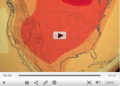
NASA Climate Change Video: This Is The U.S. In 2100. Story (and video) courtesy of
Mother Nature Network; here's a clip: "
The
United States will be a much hotter place at the end of the 21st
century, according to a new climate change visualization released by
NASA this week. The video illustrates a small component of the upcoming National Climate Assessment,
set to come out in 2014, which provides Congress with the most
up-to-date information on the state of climate change in the country
from more than 240 contributing climate scientists. The last report was
published in 2009. Researchers at NASA's Goddard Space Flight Center
teamed with scientists at the National Oceanic and Atmospheric
Administration's National Climatic Data Center (NCDC) in Asheville,
N.C., to create a new video, which compares two different climate
change scenarios: One in which atmospheric carbon dioxide levels
increase from today's level of 400 parts per million
to 550 ppm, and a second in which carbon dioxide levels double to 800
ppm. (Parts per million means that, for example, for every million
molecules of air, 400 of them are carbon dioxide.).."
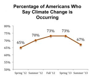
Troubling Trends. Here's a recap of a recent poll at
The University of Texas
which shows a drop in the percentage of Americans who believe climate
change is underway. I found it interesting that people who are living
with kids under the age of 18 are much more likely to acknowledge the
science: "
Sixty-seven percent of Americans say that climate change
is occurring, down from 73 percent in March, according to the latest
survey conducted by the University of Texas Energy Poll. Eighteen
percent of respondents say that climate change is not occurring and 15
percent report they don’t know. The online nationwide survey, conducted
July 18-22, indicates that although climate change can be a polarizing
issue politically, both Democrats and Republicans experienced similar
declines from where numbers were in March. Over the past four months,
the percentage of Republicans who say that climate change is occurring
dropped from 55 to 51 percent and Democrats decreased from 89 to 84
percent..."
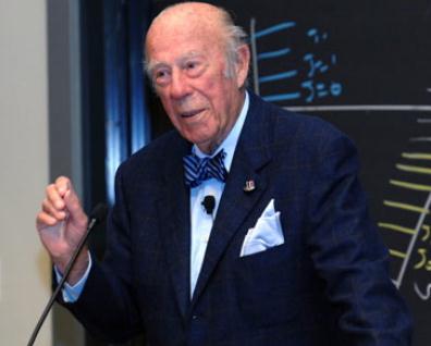
A Republican Secretary Of State Urges Action On Climate Change. Here's a clip from a story at
Yahoo News: "
As
Secretary of State under President Ronald Reagan, George Shultz helped
negotiate the most successful global environmental treaty to date: the
Montreal Protocol, which phased out the use of chlorofluorocarbons
and other ozone-depleting chemicals. Those chemicals also act as
potent greenhouse gases, so the agreement also makes him the negotiator
of one of the most effective global climate treaties ever, despite
being part of an administration that famously removed solar technology from the White House roof. Few modern Republican politicians favor such environmental effort, or even believe climate change is happening or that humanity could be primarily responsible for it..."
Photo credit above: M.I.T.
Climate Change Steers New Insurance Course. If
increasingly extreme weather doesn't open up eyes, maybe a look at your
next insurance premium will. Here's an excerpt of a story at
Westfair Communications: "
People
may still have their doubts about climate change, but it’s already
affecting property owners’ bottom lines. According to industry reports,
property insurance rates have increased more than 5 percent over the
last year in places like Connecticut that have a high exposure to
natural disasters such as hurricanes, tornadoes, blizzards or
wildfires. Experts agree the frequency of such disasters is expected to
increase with climate change, and as a result, there’s a heightened
focus on the insurance industry and how property owners can protect
themselves..."


