"
This will be extremely dangerous and life threatening stsorm of an epic magnitude rarely experienced. All people in the area should take precautions to safeguard their lives and property." - National Weather Service discussion out of Fairbanks, tracking what may Alaska's most dangerous storm since 1974. Details below.
 2011 Storm Facts
: 7th hurricane season to have 18 or more storms. Also 1st time we’ve had 18 or more storms in consecutive seasons, with 2010 having 19 storms.
Year # of Storms:
2011 18*
2010 19
2005 28
1995 19
1969 18
1933 21
1887 19
*Number could still go up
 No Snow as of November 8 - how unusual is that?
 I asked Pete Boulay at the Minnesota State Climate Office. Here is his response: "It is fairly unusual. The median date for the first trace of snow in the Twin Cities is October 16. Since 1948 the Twin Cities has gone as late as November 21 (1953) when 1.5" of snow fell. There have been 4 other years since 1948 when the "first trace" of snow has been November 9 to the 12th.
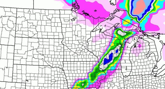
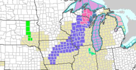
Near Miss. A plowable snowfall is still possible across much of central Wisconsin, at least 4-8" from near Black River Falls and the Wisconsin Dells to nera Oshkosh and Appleton.
 Winter Weather Advisories
. 2-6" of snow is expected from near Des Moines to Waterloo, the Wisconsin Dells, Oshkosh and Green Bay. The latest watches and warnings for the USA are
here.
Correction: in the October 24 (print) weather column I mentioned U.S. traffic accident statistics, claiming 7,400 deaths and 670,000 injuries. It turns out those numbers were inaccurate - much too low. As recently as 2009 there were 33,808 accident-related fatalities and 2,217,000 injuries, according tot he U.S. Department of Transportation. Thanks to Glenn Breitag from Northfield for passing on the correct numbers. Sorry for the mistake.
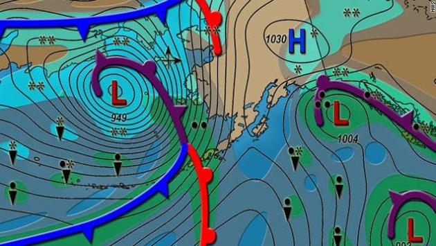
Alaska Faces One Of Its Worst Storms Ever, Forecasters Say. This storm is deeper/stronger than some major hurricanes.
CNN has a good overview of the threat: "
Alaska is facing a life threatening winter storm with near hurricane force winds, more than a foot of snow and severe coastal flooding, the National Weather Service says. "This is an extremely dangerous and life-threatening storm which will be one of the worst on record over the Bering Sea and the west coast," NWS forecasters said in a bulletin Monday afternoon. Winds near hurricane force of 74 mph were expected to generate seas as high as 25 feet in the northern Bering Sea, forecasters said. The winds were expected to raise sea levels as much as 9 feet in the Norton Sound. Those levels combined with the high waves were expected to cause significant coastal erosion and major flooding. The winds may also push sea ice on shore, adding to the dangers, NWS forecasters said."
 Unlike Anything I've Ever Seen Before
. Check out this
verbage from the Fairbanks office of the National Weather Service:
THIS WILL BE AN EXTREMELY DANGEROUS AND LIFE THREATENING STORM...
THE WORST ON RECORD SINCE THE BERING SEA STORM OF NOVEMBER 10 TO
11 IN 1974. ALL RESIDENTS SHOULD TAKE ACTION NOW TO PREPARE FOR
THE STRONG WINDS AND COASTAL FLOODING.

THE STORM WILL GENERATE SOUTHEAST WINDS 50 TO 70 MPH OVER MUCH OF
THE WEST COAST STARTING TUESDAY EVENING AND CONTINUING INTO
WEDNESDAY NIGHT. THERE WILL BE PEAK GUSTS TO 90 MPH WHERE THE WIND
IS CHANNELED BY HILLS. THE STRONGEST WINDS WILL BE ON TUESDAY
NIGHT AND EARLY WEDNESDAY. ON WEDNESDAY...THE WINDS WILL TURN
SOUTHWEST AND BEGIN TO DIMINISH IN THE AFTERNOON AS THE STORM
MOVES PAST BERING STRAIT.

THE STORM SURGE ASSOCIATED WITH THIS STORM WILL CAUSE TIDES TO BE
8 TO 10 FEET ABOVE NORMAL ALONG THE WEST COAST FROM THE YUKON
DELTA UP TO BERING STRAIT. WEST AND SOUTH FACING COASTLINE WILL BE
THE MOST AFFECTED. MAJOR COASTAL FLOODING WILL BEGIN TUESDAY
NIGHT AND CONTINUE THROUGH EARLY THURSDAY. IN EASTERN NORTON
SOUND THE FLOODING WILL BEGIN EARLY WEDNESDAY MORNING AND CONTINUE
THROUGH THURSDAY AFTERNOON. SEVERE BEACH EROSION IS EXPECTED WHERE
THE COAST IS FREE OF ICE. SEA ICE BORDERING THE SHORELINE MAY BE
PUSHED ONSHORE.
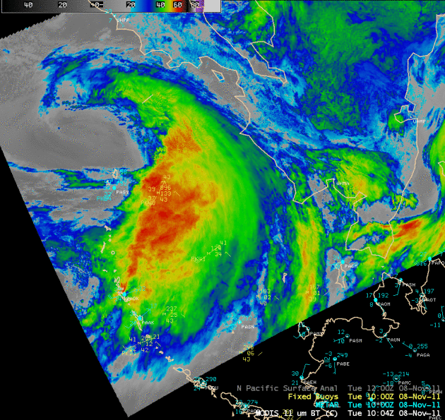
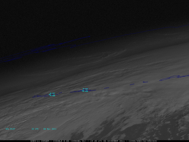
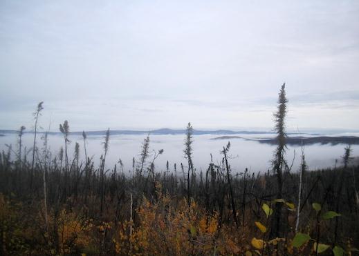
More details on Alaska's pending super-storm from Fairbank's
newsminer.com : "
FAIRBANKS - A severe storm along Alaska’s western coastline could cause flooding in the northwest Alaska village of Kivalina, according to the National Weather Service. “A once in 30-50 year storm is due to arrive in the north Bering Sea late Tuesday,” said Ted Fathauer with the service’s Fairbanks office. The region hasn’t seen a storm this severe since 1974. The early stages of the storm came into view late Saturday evening after a low-pressure system crossed over Japan into the Pacific Ocean, Fathauer said. Since then, it has gathered speed and strength. Winds could exceed 55 mph with gusts of 70 mph accompanied by a 3-foot storm surge. Waves of 20-25 feet are expected in the Chukchi and Bering seas. “Once a coastal flood watch is formulated, every coastal settlement in the area will be notified, whatever it takes,” said Fathauer. Kivalina, with about 400 residents, rests on a spit of land jutting into the Chukchi Sea." (Satellite image courtesy of the University of Wisconsin meteorology program).
* Reports late Tuesday night indicate mandatory evacuations underway for low-lying neighborhoods of Nome, Alaska.
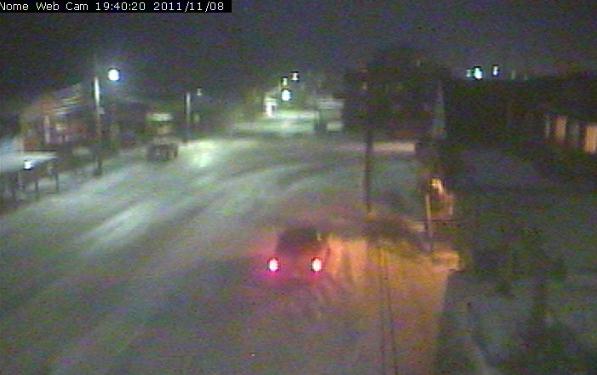 Nome Webcam
. Click here to see the latest conditions in Nome, Alaska.
 NASA: Asteroid Video.
 Here are more details and a
great video clip focusing on Tuesday's close enounter with an asteroid: “
Using radar data, scientists from NASA’s Jet Propulsion Laboratory created this six-frame movie of asteroid 2005 YU55. The data was obtained Nov. 7, 2011 using NASA’s Goldstone Solar System Radar (located at the Deep Space Network facility in Goldstone, Ca.) At the time, the space rock was approximately 860,000 miles (1.38 million kilometers) away from Earth. At its closest approach on Nov. 8, 2011, YU55 will be about 200,000 miles from Earth. It poses no threat. “
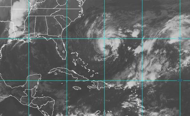 Tropical Storm Sean
. Packing 50 mph sustained winds, "Sean" is churning up 10-15 foot seas between the Bahamas and Bermuda.
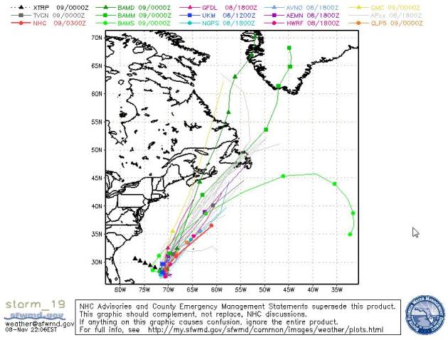 Projected Track
. All the NHC computer models whisk "Sean" to the north/northeast, possibly impacting the Canadian Maritimes by Friday.
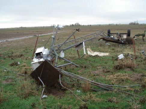 Tipton, Oklahoma Mesonet Destroyed.
 The tornado that touched down on Tipton, Oklahoma Monday destroyed the local, automated weather station. Here is a
graph showing the last observations before the twister struck (click on 3 day observations). Image courtesy of the Oklahoma Mesonet.
 Could Terrain Influence Tornado Formation?
 I've wondered the same thing over the years - people describe "favored tracks" for tornadoes up river valleys, etc.
Al.com takes a look: "
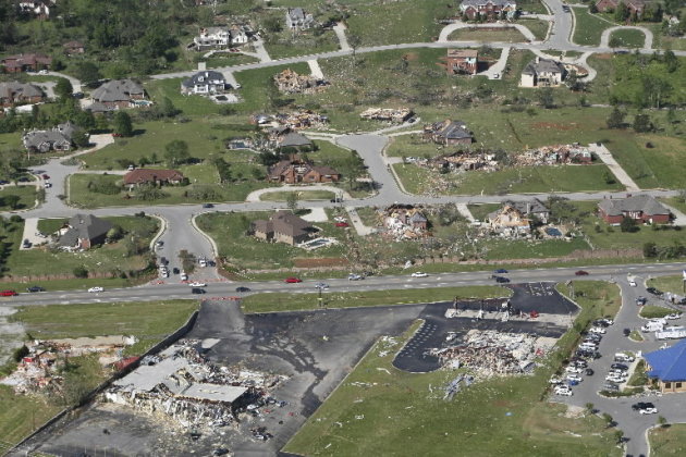
HUNTSVILLE, Alabama -- The idea first occurred to Kevin Knupp after the deadly 1989 tornado that hit Airport Road. Is it possible that an area's topography and surface characteristics can influence a tornado? More than 20 years later, Knupp - a professor of atmospheric sciences at the University of Alabama in Huntsville - is continuing to advance that theory. If true, it could give more insight into the phenomenon of tornadoes. But drawing firm conclusions on a tornado's influence is difficult because twisters are rare and, Knupp said, "the (scientific) process is slow."
Photo credit above: "
An aerial photo of Anderson Hills subdivision following the April 27 tornadoes. The subdivision rests on a downslope, which UAH Professor Kevin Knupp said may cause tornadoes to intensify. (The Huntsville Times file photo)"
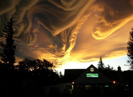
Cloud Appreciation Society. Cloud Lovers Unite! If you're a weather enthusiast you may get a charge out of checking out this site, the
Cloud Appreciation Society: "
At The Cloud Appreciation Society we love clouds, we’re not ashamed to say it and we’ve had enough of people moaning about them. Read our manifesto and see how we are fighting the banality of ‘blue-sky thinking’. If you agree with what we stand for, then join the society for a minimal postage and administration fee and receive your very own official membership certificate and badge." (photo above is an amazing example of "asperatus clouds", a new class of clouds recently discovered and documented).
 Wake Up And Smell ..... The Internet? Neatorama.com
 has the next evolutionary phase of the World Wide Web: "
Meet Olly, a "web connected smell robot" that converts tweets, Facebook notifications, RSS feeds - whatever you want - into smells:
Olly has a removable section in the back which you can fill with any smell you like. It could be essential oils, a slice of fruit, your partner's perfume or even a drop of gin. [...] Olly is stackable, so if you have more than one, you can assign each one to a different service with a different smell. Connect one to Twitter and another to your calendar. Before you know it, you'll have a networked internet smell centre."
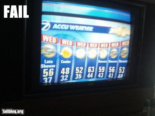
 PG-Rated Weather Page
. Well, that's one way to make a point.
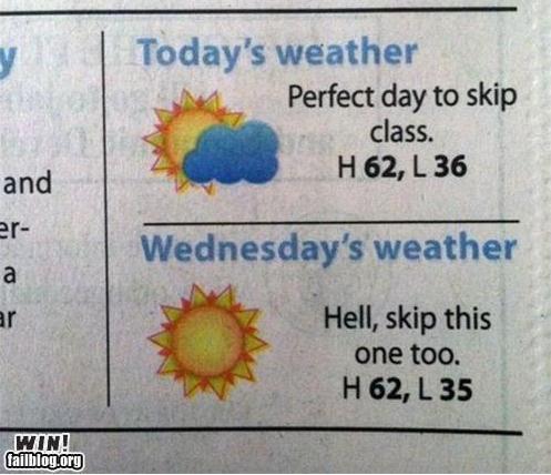
 Ah, If Every Day Could Be A Wednesday
. Image frame grab courtesy of failblog.org.
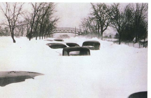
 Armistice Day Blizzard.
 This photo was taken in St. Louis Park on November 12, 1940 - 10 to 15 foot drifts common across the Twin Cities metro. Photo courtesy of the Minnesota Historical Society.
"Snowfall Inflation"
Our biggest fear as meteorologists? Missing a tornado that threatens neighborhoods - and - predicting flurries, only to wake up the next morning to a foot of flurries - and - forgetting to wear pants in front of the green screen. But I digress. Not good. So we compensate. I think we're all still haunted by the Armistice Day Blizzard of Nov. 11-12, 1940. The forecast that day called for flurries. The subsequent storm sparked a 50 degree temperature drop, 20 foot drifts. 145 people died. That was before computer models, but it had a huge impact on forecasters.
It's better to predict 4" (and wind up with 1") than the other way around. Viewers have long memories. That's why we tend to over-predict snowfall amounts. Nobody wants to get caught with their Doppler down.
Climate Stories...
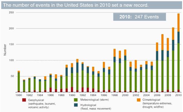
A New Record: 14 U.S. Billion-Dollar Weather Disasters in 2011. Joe Romm at
Climate Progress has the details: "
In September 2010, Munich Re one of the world’s leading reinsurers, wrote “the only plausible explanation for the rise in weather-related catastrophes is climate change.” In January, they summed up 2010 this way: “The high number of weather-related natural catastrophes and record temperatures both globally and in different regions of the world provide further indications of advancing climate change.” Last week meteorologist and former hurricane hunter Dr. Jeff Masters analyzed 2011, “Fourteen U.S. billion-dollar weather disasters in 2011: a new record,” which I excerpt below:
"It’s time to add another billion-dollar weather disaster to the growing 2011 total of these costly disasters: the extraordinary early-season Northeast U.S. snowstorm of October 29, which dumped up to 32 inches of snow, brought winds gusts of 70 mph to the coast, and killed at least 22 people…. The damage estimate in Connecticut alone is $3 billion, far more than the damage Hurricane Irene did to the state. Hundreds of thousands still remain without power a week after the storm, with full electricity not expected to be restored until Monday. The October 29 snow storm brings the 2011 tally of U.S. billion-dollar weather disasters to fourteen, thoroughly smashing the previous record of nine such disasters, set in 2008. Between 1980 – 2010, the U.S. averaged 3.5 of these weather disasters per year. Through August, the National Climatic Data Center (NCDC) estimated that ten weather disasters costing at least $1 billion had hit the U.S., at total cost of up to $45 billion. However, the October 29 snow storm brings us up to eleven billion-dollar disasters, and a new disaster analysis done by global reinsurance company AON Benfield adds three more."
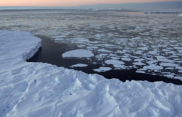
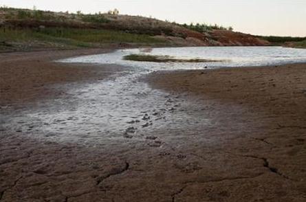
Storms May Have Prevented Record Loss Of Arctic Ice.
Yahoo News has the story: "
DENVER - The amount of Arctic sea ice hangs on through the summer is partly dependent on the storminess of the weather, according to a new study. The research finds that in years when the weather in the Arctic is calm, more ice is lost by the end of the Arctic summer. Arctic sea ice has been in overall decline for decades now, reaching a record low in September 2007 and almost hitting that record again in 2011. But while the trend is toward more melting of sea ice, the year-to-year measurements wobble up and down. The new research, presented Oct. 27 at the World Climate Research Program meeting here, found that storms account for much of that yearly variation. In fact, it may have been a stormy summer that saved 2011 from beating the 2007 sea ice-loss record, said study researcher James Screen of the University of Melbourne. The ice seemed on track to melt faster than in 2007, but then storms ravaged the Arctic for several weeks in July, Screen told meeting attendees."
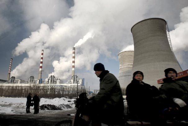
Biggest Jump Ever Seen In Global Warming Gases. Here's an update from AP and the
Seattle Times: "
The global output of heat-trapping carbon dioxide jumped by the biggest amount on record, the U.S. Department of Energy calculated, a sign of how feeble the world's efforts are at slowing man-made global warming. The new figures for 2010 mean that levels of greenhouse gases are higher than the worst case scenario outlined by climate experts just four years ago. "The more we talk about the need to control emissions, the more they are growing," said John Reilly, co-director of MIT's Joint Program on the Science and Policy of Global Change. The world pumped about 564 million more tons (512 million metric tons) of carbon into the air in 2010 than it did in 2009. That's an increase of 6 percent. That amount of extra pollution eclipses the individual emissions of all but three countries - China, the United States and India, the world's top producers of greenhouse gases."
Health Cost Of 6 U.S. Climate Disasters: $14 Billion. The story from
Reuters: "
Deaths and health problems from floods, drought and other U.S. disasters related to climate change cost an estimated $14 billion over the last decade, researchers said on Monday. "When extreme weather hits, we hear about the property damage and insurance costs," said Kim Knowlton, a senior scientist at Natural Resources Defense Council and a co-author of the study. "The healthcare costs never end up on the tab." The study in the journal Health Affairs looked at the cost of human suffering and loss of life due to six disasters from 2000-2009. "This in no way is going to capture all of the climate-related events that happened in the U.S. over that time period," Knowlton said. "At $14 billion, these numbers are big already." To put this in context, 14 weather disasters in the United States so far this year have cost at least $14 billion, according to Jeff Masters of the Weather Underground website. Masters said by email that health costs and deaths are considered in some of the data used to reach this figure."
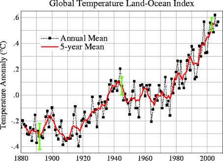
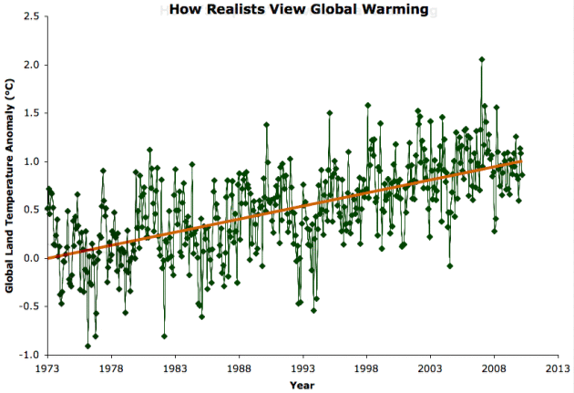 How Global Warming "Skeptics" Roll. The graphic above tells it all - professional deniers will continue to cherry-pick data. In fact, for some of these professional skeptics there is no evidence, no smoking gun, that will ever change their minds. Planetsave.com has more:
 "
This dynamic graph (or GIF, to be technical) is one of the best graphics I’ve seen (ever.. on any topic). It so accurately explains, or showcases, global warming “skeptic” (i.e. denier) logic. Basically, it highlights how they can go on cherry picking for ages and continue saying “the world is cooling” when it’s obviously warming."
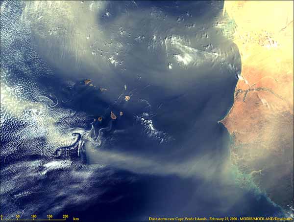
Dust Obscures Picture Of Hurricanes In Warming World. Another intriguing story from
Yahoo News: "
Scientists have a pretty good idea that hurricanes will become less frequent and more intense due to climate change, said oceanographer Chunzai Wang during a recent visit to the National Oceanic and Atmospheric Administration's Atlantic Oceanographic and Meteorological Laboratory (AOML) in Miami, where scientists study everything from ocean acoustics to hurricane forecasting. But other curveballs that recently have come to light complicate the picture. One is dust. Every year, storms over West Africa disturb millions of tons of dust, and strong winds carry those particles westward into the skies over the Atlantic Ocean, where many hurricanes form. [Infographic: Storm Season! How, When & Where Hurricanes Form] During a dust spike triggered by heavy rainfall, there's a drop in hurricanes in the Atlantic basin, Wang said. As the dust spreads into the atmosphere, it increases what's called the vertical wind shear, the change in wind direction that comes with height, Wang said. That's bad news for hurricanes, because too much wind shear can break up tropical cyclones (the general term for hurricanes and tropical storms)." Image above courtesy of NASA.
Commentary: Science Trumps Climate Change Deniers. Here's an Op-Ed in the
Kansas City Star: "
Richard Muller was supposed to be the white knight for the deniers of global warming, smiting the fire-breathing activists who insist that climate change is real. In the end, though, science prevailed. Muller, a well respected physicist at the University of California, Berkeley, has long been a critic of the scientific methods used to determine whether the climate is, indeed, changing and whether humans are responsible in any way. Two years ago, Muller and his team at Berkeley set out to examine the evidence compiled by mainstream scientists and set the matter straight. While Muller insists that all he is interested in is promoting sound scientific studies, his project must have sounded promising enough to the Koch brothers, who ended up funding a quarter of the $600,000 cost of the study. The brothers, Charles and David, run the largest privately held company in the U.S. Since the 1980s, foundations formed by the Koch brothers have spent more than $100 million on conservative organizations and causes. Koch Industries is involved in oil and other endeavors that produce large amounts of greenhouse emissions, and the Kochs have bankrolled numerous efforts to discredit climate scientists."
 Warming Arctic Wakes Up Methane And Microbes, Study Shows
. The
Medill School at Northwestern has the story: "
As global warming pushes temperatures in the Arctic up faster than anywhere else, concern is rising about releasing the vast reservoir of greenhouse gas-forming carbon trapped in permafrost. The fate of the carbon could rest on some of the tiniest inhabitants of the frozen landscape: millions of microbes that respond rapidly to thaw, according to new research published in the on-line edition of Nature this week. Microbes frozen for thousands of years can spring to life and digest the carbon to release heat-trapping gases into the atmosphere, amplifying warming and melting. Scientists can't yet predict how much of the carbon stored in Arctic permafrost will reach the atmosphere, but microbes could play a pivotal role."
Outrunning Climate Change. The story from
Conservation Magazine:"
So, climate change scrambles your cozy coral reef or welcoming wetland. You gotta move – the new climate is driving you crazy! But how far… and how fast? That’s the question a team of researchers tries to answer in a new study of the pace of thermal shifts. Greenhouse gases have warmed the land by approximately one degree Celsius since 1960, the researchers note in Science, and that is roughly three times faster than the rate of ocean warming. But “different regions are warming or even cooling at different rates,” the authors note, “so uniform responses across the globe to climate change should not be anticipated.” Instead, organisms will have to move at different paces to maintain their “thermal niches.” To see just how fast those niches are shifting, the researchers analyzed global temperature records from 1960 to 2009, and then calculated how fast temperatures were shifting across land and ocean. Surprisingly, despite the differences between land and sea, they found that organisms would need to move at similar rates to keep pace with climate change. On land, they’d need to travel about 2.7 kilometers (1.6 miles) per year; in the oceans, about 2.2 kilometers (1.3 miles) per year."