First Snow. Much of Minnesota saw the first accumulating snow of the winter season on Saturday. Amounts generally ranged from 1-3" across most of the Twin Cities metro, closer to 3-6" for St. Cloud, with a narrow band of as much as 11" near Sartell and St. Stephen, in central Minnesota. Details below.
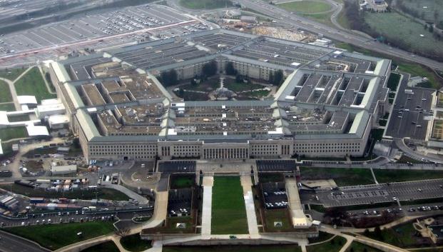
"A new report from the Defense Science Board (PDF) recommends that the U.S. Department of Defense needs to have a much broader understanding of global climate change because it represents a fundamental threat to U.S. and international security." - from a Digital Trends story below about climate change posing a risk to U.S. national security.
"By the end of the century, expect heat waves that occur on average every 20 years now to take place every two years, Field says. Likewise, the number of storms delivering heavy precipitation by century's end is expected to grow. The storms include tropical cyclones as well as winter storms in the northern mid-latitudes." - Christian Science Monitor article on climate change and extreme weather.
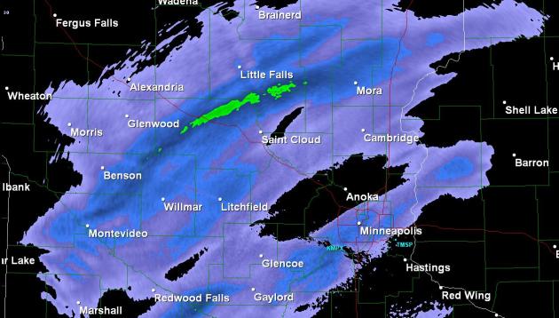
Fickle Snow Bands. We knew it would snow, but where (precisely) the heaviest snow band(s) would set up was a mystery. We had a hunch central Minnesota would see the heaviest snowfall amounts, but nobody predicted that a band of moderate snow would STALL over Stearns county, resulting in 11" of snow for St. Stephen and Sartell. Wow. You can see the band (bright green) responsible for the most extreme snowfall amounts. Meanwhile Brainerd picked up less than an inch.
* You can also see the second band of (moderate) snow that set up right over the Twin Cities metro, especially southern suburbs - where it snowed pretty hard for 3-4 hours, just long enough for some 3-3.5" amounts.
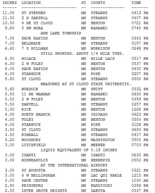
Snowfall Reports. On Friday, if I had gone on the air and predicted 1-11" the men with the little white suits would have come into the studio and whisked me away to the Home For Wayward Weathermen. Spending a little time there sounds pretty good, come to think of it. Quite a range. The Golden Snow Shovel Award goes to St. Stephen and Sartell with a whopping 11" of snow. St. Cloud picked up 3.5 to 5.8". The Twin Cities metro area generally saw 1-3", with 3.2" at Woodbury and 4" at North Branch. All in all the forecast worked out pretty well - at least this time around. More totals from the NWS here.
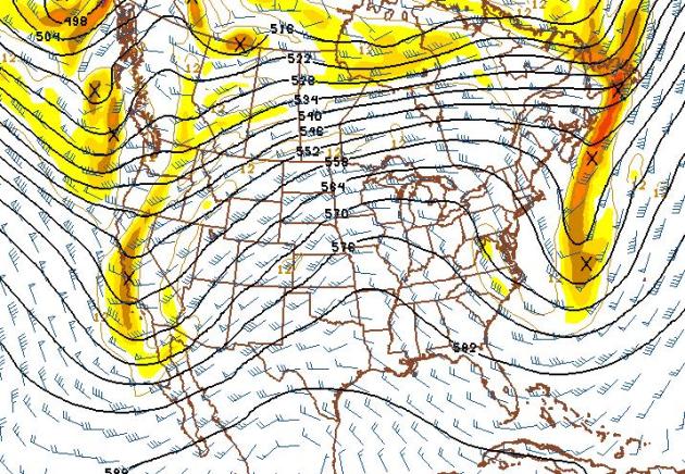
Thanksgiving Preview. The map above is valid noon on Thursday, showing an impressive ridge of high pressure over much of the USA, a dome of warm, dry, sinking air - capable of supporting highs in the 50s, even some 60s from Des Moines and Chicago on south, 70s over the southern Plains states. Stormy weather is likely for California and the Pacific Northwest, a cold wind for New England - but no major storms are brewing east of the Rockies.
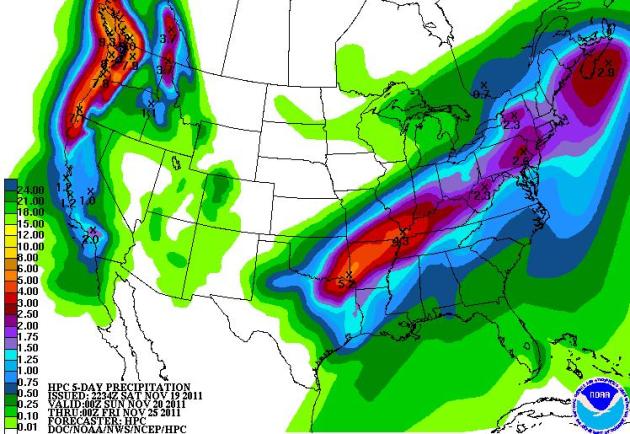
5-Day Rainfall Prediction. The latest QPF shows a potential for 3-5" rains for the Mid South, over 2" into Philadelphia and New York City by midweek. Soaking rains are likely for the Pacific Northwest, as much as 4-7" rain, and a few feet of snow for the Cascade and Coastal Range.
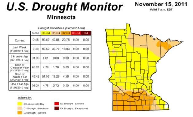
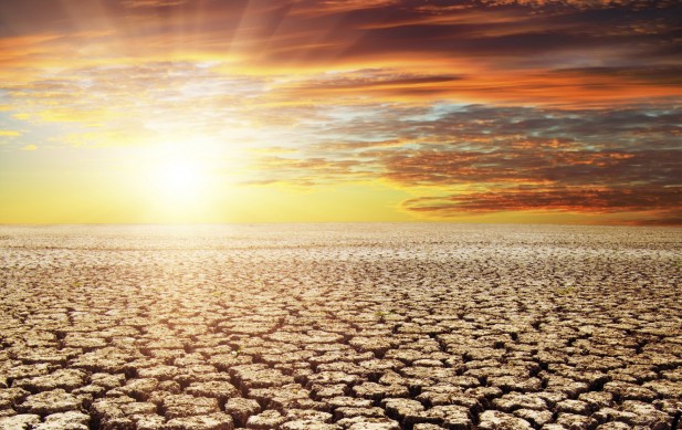
Deepening Drought. As much as I'm enjoying the storm-free weather (on some level) we really need some moisture, and soon - before the ground freezes us solid in a couple of weeks. Over 99% of Minnesota is "abnormally dry", over 40% of the state in a moderate drought, 20.75% of Minnesoeta in a severe drought. For much of southern Minnesota this will probably be one of the 3 driest autumns in 141 years of record-keeping. More information from the Drought Monitor here.


Keeping Our Sense of Humor. Thanks to Tricia Frostad for passing this along - courtesy of ihasahotdog.com.
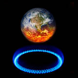
Climate Stories....
A Bad Month For Climate Skeptics. Here's an Op-Ed from The Washington Post: "THE PAST MONTH hasn’t been good for climate-change skeptics. At a congressional hearing Monday, Richard Muller, a former global-warming skeptic at the University of California, Berkeley, told lawmakers that, after a two-year review of historical world temperature data, he has verified the scientific consensus that the earth is warming — by about 1.6 degrees Fahrenheit over the past 50 years. This is not surprising; as the National Oceanic and Atmospheric Administration reported last year, the warming of the planet, detected in multiple, independent lines of evidence, is “unequivocal.” Mr. Muller said that exactly how much humans contribute to such warming is difficult to calculate. But, as the Economist pointed out last year, even if the U.N. Intergovernmental Panel on Climate Change (IPCC) is off by a factor of five in its reckoning of the climate’s sensitivity to an eventual doubling of the amount of carbon in the atmosphere, that still leaves only a 50 percent chance of relatively minor temperature change. The developed world and large developing nations, meanwhile, continue to pump immense amounts of carbon into the atmosphere. The Energy Department released an analysis this month concluding that global carbon emissions in 2010 increased by the largest amount ever, to a higher level than the IPCC’s worst-case projection."
* The summary IPCC report is here.
Weather Disasters Increasing From Climate Change, Says U.N. Environmental-expert.com has the story: "A definitive UN science report released today confirms the link between climate change and extreme weather events, including punishing heat waves, droughts, and torrential rains and resulting floods. The report warns that the U.S. will suffer heat waves, droughts, and more powerful hurricanes like Irene, with vulnerable people and places likely to suffer most from extreme weather, including low-lying island States facing sea level rise and stronger storm surges, and drought-prone countries in Africa. New York released its own climate study this week, predicting that with expected sea level rise and stronger storms, future hurricanes could flood the tunnels into Manhattan within an hour and put one-third of the city underwater, with climate induced impacts beginning within a decade. The cost of US weather disasters in 2011 is already approaching $50 billion, according to the National Climate Data Center. It is now certain that human emissions of greenhouse gases and warming aerosols like black carbon are increasing the frequency and intensity of extreme weather by putting more heat energy into the climate system."