"Final numbers and an analysis are expected from the hurricane center by Nov. 28, but preliminary NHC numbers are 18 named storms, six turning into hurricanes and three of those into severely damaging hurricanes. The numbers, coincidentally, are dead-on to the center's pre-season forecast, which was for an above-average season." - article below in the Post and Courier focused on the 2011 hurricane season.
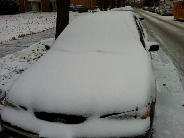
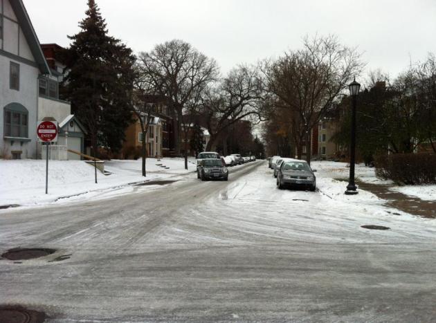
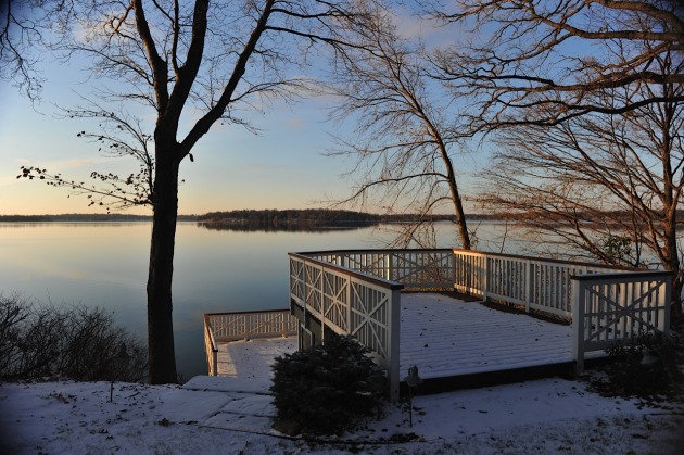
First Snow. Downtown Minneapolis picked up nearly 3" of snow on Saturday, the first accumluting snow of the season. St. Paul picked up a little less, closer to 2", but still plowable and "shovel-able" in most neighborhoods. Uptown photos courtesy of WeatherNation's Walt Kruhoeffer.
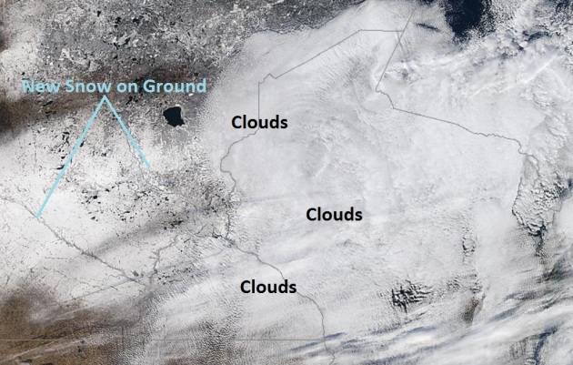
Fresh Snow. Here's the midday Sunday "Modis" high-res satellite image from NASA's low-orbiting "Aqua" satellite. You can see the difference between lingering cloud cover over southeastern Minnesota and Wisconsin, and fresh snow on the ground over Minnesota (where the lakes and rivers show through).
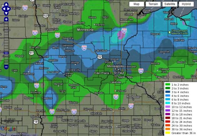
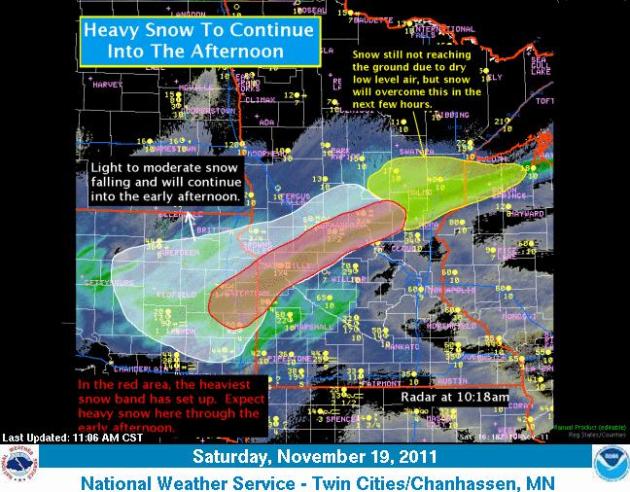
How Much? The Chanhassen office of the National Weather Service created a map showing the extremes across the state from Saturday's snowfall. More information here.
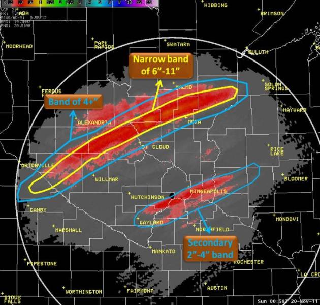
Fickle Snow "Bands". Sometimes people imagine one, big (uniform) shield of snow, where just about everyone sees the same amount from a winter storm. I wish nature worked like that. Analogous to a summer T-shower regime, where some towns get soaked, while other communities just a few miles down the road see no rain whatsoever, jet features and gravity waves can impact winter storms, resulting in big variations over a relatively short distance. Map above showing Doppler snowfall estimates courtesy of the MPX National Weather Service office in Chanhassen.
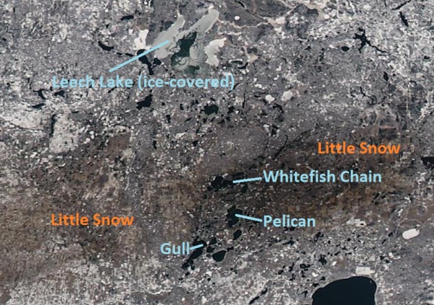
Time For Your Close-Up. The detail on the 250 meter NASA "Terra" images is pretty incredible. You can see that ice has begun to form on Leech Lake, while Pelican, Gull and the Whitefish Chain are still ice-free (as of midday Sunday). Note the lack of snow north of Brainerd. Saturday's storm missed the Brainerd Lakes area altogether - the heaviest (8-11") snow bands shifted 75 miles farther south, setting up over Stearns and Benton counties.
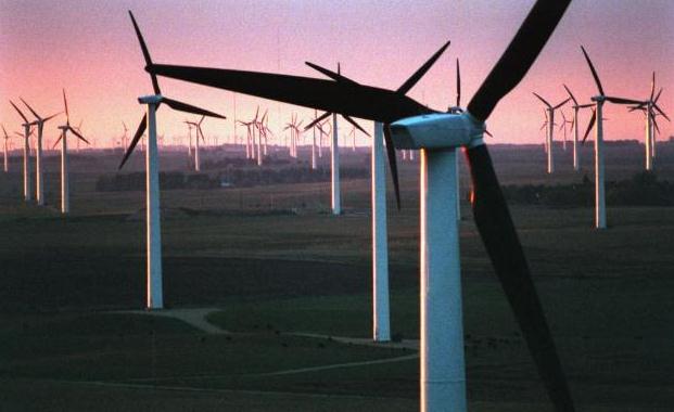
Indiana Feels The Power Of Minnesota's Wind. An interesting story from the Star Tribune: "The people in Lakefield, a small farming community in southwest Minnesota, can look across the prairie in three directions and see fields of wind turbines. But the blades aren't turning for them. The 137 machines that tower above rows of corn and soybeans produce electricity for a utility two states away: Indianapolis Power & Light Co. The wind farm, commissioned last month, is the first in Minnesota built solely for export. Across the nation, utilities are looking far afield for wind power, often to satisfy clean energy goals. The practice, which began on the East and West coasts, is becoming common in the Upper Midwest, which some experts believe is poised to become a major exporter of wind power."
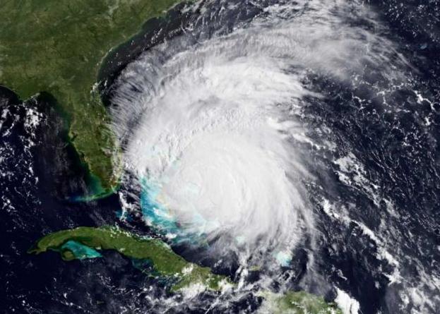
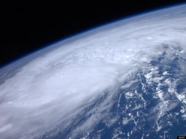
Hurricane Season Is Fading. Here's a recap of the 2011 season from the Post and Courier: "It's all over but the counting. The 2011 hurricane season blew away on a winter storm that came through the United States in early November and pushed Tropical Storm Sean far out to sea. Since then the tropics have been quiet. What seemed to be a mild season produced a couple of surprises, though. It's been one of the busier years on record and it produced one of the costliest storms -- Hurricane Irene. Only two factors kept Irene from wreaking more havoc here than it did. "Pure dumb luck and timing," said Mark Malsick, S.C. Climate Office severe weather liaison. When the August storm was about two days southeast of the Lowcountry, a weather front coming off the East Coast developed a trough, a weakness that drew Irene north instead of northeast. If it hadn't developed just at the right time, "Irene's northwest track over the Bahamas would have taken it just east of Beaufort," Malsick said."
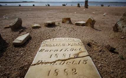
Depleted Texas Lakes Expose Ghost Towns, Graves. AP reports on the eerie things that are showing up as lake water levels in Texas reach new lows: "BLUFFTON, Texas (AP) -- Johnny C. Parks died two days before his first birthday more than a century ago. His grave slipped from sight along with the rest of the tiny town of Bluffton when Lake Buchanan was filled 55 years later. Now, the cracked marble tombstone engraved with the date Oct. 15, 1882, which is normally covered by 20 to 30 feet of water, has been eerily exposed as a yearlong drought shrinks one of Texas' largest lakes. Across the state, receding lakes have revealed a prehistoric skull, ancient tools, fossils and a small cemetery that appears to contain the graves of freed slaves. Some of the discoveries have attracted interest from local historians, and looters also have scavenged for pieces of history. More than two dozen looters have been arrested at one site."
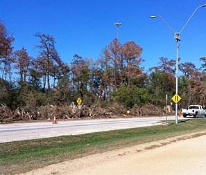
Texas And Somalia Still Coping With Dangerous Droughts. I didn't realize it had come to this. Drought-stricken trees being cut down in Houston, Texas? AccuWeather.com has the story: "It's a helpless feeling to watch nature die. Amanda Assali, of Houston, feels that way. She said it's devastating. First, she read an article about how the drought was killing a huge number of trees in the city. A week later, she went for a run in Memorial Park, a large inner-city park in Houston. "That day as I was jogging, I saw city crews cutting down trees. Tons of trees. They had to cut them because as they died, they would become brittle and break," she said. "It was one of the saddest things I felt as a result of the drought." That's exactly what's going on all over Texas, which is experiencing an unprecedented amount of wildfires and a lengthy drought."
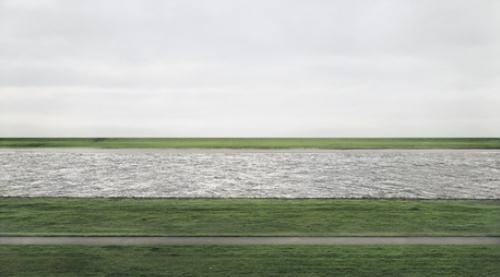
Why Is This Photo Worth $ 4 Million? Good question. It's a very nice photograph, calming and simple. NPR has a few ideas: "Does it come with several Ferraris?" offers an arts editor here. Well, that would make more sense, but no, not that we know of. "One can only assume the collector really likes stripes of green and gray," jokes SeattlePI.com. Unfortunately, though, we don't know who bought it. Andreas Gursky's Rhein II fetched $4,338,500 at a Christie's auction last week, breaking the record for the most expensive photograph ever sold at auction. Here's what we do know: The photo comes at the mammoth proportion of about 6-by-11 feet, and that's got to count for something. Plus (sorry all starving photographers), that price tag is nothing unusual for Gursky. Until the purchase of Cindy Sherman's Untitled in May, Gursky's 99 Cent II Diptychon had been the most expensive photo, which sold at Sotheby's for $3.3 million in 2007. He has photos in major museums like the Museum of Modern Art and London's Tate Modern and studied under the renowned Bernd and Hilla Becher in Germany."
Photo credit: Andreas Gursky/Christie's Images, Ltd., 2011 Rhein II
Weather Challenges
"All weather, like politics, is local." We care about the weather floating above our homes, commutes, offices and cabins. The 7-Day is an average, weighted for the metro area, where 85% of us live.
It's probably human nature to remember the biggest number. Predict 3-6"? People expect 6" in their yard. Tell that to folks up in Sartell, digging out from 11" of Saturday snow, while 4 miles down the road, downtown St. Cloud saw closer to 4". Good grief! A heavy snow band stalled for 6-8 hours, resulting in a thin stripe of serious accumulation. Minneapolis saw 3", 2.5" at St. Paul, with 1" in Orono.
So in perfect 20/20 hindsight my Friday forecast should have read "1 to 11 inches, give or take." I tried that once...but the men with the little white jackets tried to haul me off to the Home For Wayward Weathermen. It's peaceful. You'd like it there.
Welcome to a mercifully quiet week; the storm track well south/east of Minnesota, heavy rain from Little Rock to Boston through midweek.
A Pacific storm buffets the west coast, pulling unusually mild air into Minnesota; 50 possible Thanksgiving Day. A little rain/drizzle is possible for Black Friday but no problems getting home Sunday.
Climate Stories....

Global Warming: Two Degrees Too Far. The story from the International Business Times: "To some, global warming is still a myth - something that has been concocted to scare people into reducing their emissions. However for scientists, global warming is true, and warns that if carbon dioxide emissions are not reduced or stopped, global warming's 2 degree-Celsius increase will be inevitable. According to a study done by an international team of scientists, that was led by the University of Exeter, limiting the effects of global warming to safe levels require reducing CO2 emissions within the next two decades, which will eventually lead to zero emissions. In the study, the scientists tackled how steep a reduction is needed and how soon should it begin, as well as how quickly emissions need to drop in the next few decades."

Global Warming To Open The Floodgates On New York City. The New York Daily News focuses in on what a recent report on climate change and weather extremes might mean for America's largest city: "ALBANY — If global warming does its worst in the future, the city will need far more than just life rafts to save itself from economy-swamping floods. A state report on climate change predicts the city’s underground transit network, in particular, could be drenched often as warming global temperatures cause sea levels to rise. “The frequency of flooding will drastically increase, which means the cost of flooding will increase horrendously,” said Klaus Jacob, a scientist at Columbia University’s Lamont-Doherty Earth Observatory. Jacob, one of the authors of the $1.5 million study, warned that a single, severe flood could lead to $80 billion in damages and economic loss. Sea Expect sea level increases between 8 and 23 inches by 2080, the alarming study released last week also said. Even higher increases, perhaps up to 55 inches, could result if glacial ice sheets melt faster than projected — an outcome that would leave the city far more vulnerable to storm surges and coastal flooding."
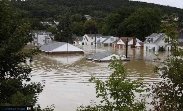
Dramatic Climate Change Expected To Be The Norm, Scientists Predict. The story from pressconnect.com: "ALBANY, N.Y. - Devastating floods, caused by the remnants of Hurricane Irene and Tropical Storm Lee, are among the climate change effects predicted in a new report written by 50 scientists and released this past week by the state's energy research agency. The 600-page report, called ClimAID, was intended as a resource for planners, policymakers, farmers and residents. It says New Yorkers should begin preparing for hotter summers, snowier winters, severe floods and a range of other effects on the environment, communities and human health. It was written by scientists from Cornell University, Columbia University and the City University of New York and funded by the New York State Energy Research and Development Authority."