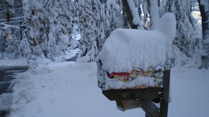
6" snow reported at Flagstaff, Arizona Saturday.
Fraying Tempers. Tempers are snapping as fast as the snow-laden branches that brought down power wires across the Northeast last weekend, with close to 300,000 Connecticut customers still in the ark and the state's biggest utility warning them not to threaten or harass repair crews. Source: AP.
“...This is the biggest storm we’ve ever had,” Reed said. “I know I said that after the tornado and I said it again after hurricane Irene. But this is the biggest.” - story on the impact of "Snow-tober on the power grid below.
14 separate billion dollar disasters in 2011. Previous record was 9 billion dollar disasters in 1998. Details below.
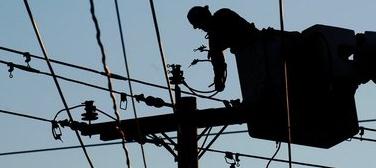
October Snowstorm "Biggest Storm We've Ever Faced" National Grid President Marcy Reed Says. Masslive.com has the amazing details: "WILBRAHAM — National Grid hopes to have power substantially restored by Friday, but isolated pockets of outages in some neighborhoods will persist through he weekend, Marcy L. Reed, president of National Grid in Massachusetts, said Friday morning following a meeting with town officials. Reed explained and defended the utility’s storm response in a town where many were still without power Friday, more than five days after an unusually heavy, wet October snowfall brought trees down on wires and utility poles around the region. “This is the biggest storm we’ve ever had,” Reed said. “I know I said that after the tornado and I said it again after hurricane Irene. But this is the biggest.”
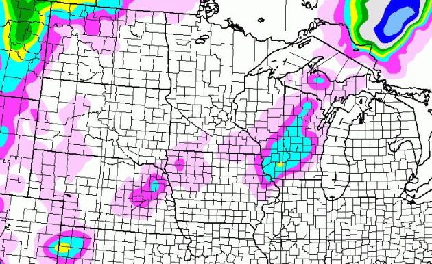

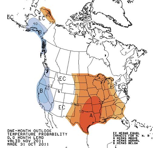
120 Hour Snowfall Accumulation. This is based on the GFS model, valid through 1 pm Thursday. The next southern storm tracks south/east of Minnesota Tuesday and Wednesday, enough cold air mixing into the circulation for a changeover to wet snow across central and southern Wisconsin, where some 1-3" snowfall amounts are possible. A little slush may fall over far southeastern Minnesota, but right now it does NOT look impressive for accumulating snow across Minnesota.
Shifting Storm Track. Storms spin up along the most significant temperature contrasts. The storm pushing into Canada will pump chilly air south of the border, pushing that temperature extreme closer to Kansas City and Chicago. Another storm is forecast to form over the panhandle of Texas and turn northeast, pushing a cold rain and possibly a little wet snow into the Upper Midwest by midweek.

LSU-'Bama Game Bright Spot In Tornado-Ravaged City. The Shreveport Times has the story of what Saturday night's epic college football game meant to the city of Tuscaloosa, Alabama - hit incredibly hard in April of this year. Finally, locals had something to feel good about, as reported by the Shreveport Times: "TUSCALOOSA, Ala. — Six months after a tornado stripped this community and its people to their core, the only discernible aspect of a pile of rubble off Hargrove Road, presumably the former site of a home, is the local battle cry — "Roll Tide" — in crimson spray paint. This town has long been painted in crimson and white; the University of Alabama boasts some of the most avid fans in the land, but the color combination doesn't simply symbolize a passion for athletics any longer. It's hope. It's a reprieve. It's all some people have left. Sports have long been crucial to the people of our country in desperate times. Amid tragedy, fans' "congratulations" become a collective "thank you." The process is certainly familiar to folks in Louisiana.The last time Tuscaloosa caught a nation's eye, 12 percent of the town of 90,000 had just been wiped out by an EF4 tornado, believed to be 1½ miles wide at times."
Billion Dollar Plus U.S. Weather Disasters Keep Piling Up. From Huffington Post: "Some initial damage reports of the massive and record-breaking snow storm of last week are in, and damage in Connecticut alone will top $3 billion, according to Connecticut Governor Dannel Malloy. The snow storm was the 14th billion dollar plus weather disaster of the year in the U.S. alone, adding to what's already been a record-breaking year for the number of billion dollar weather disasters. The previous record the number of billion dollar disasters in one year was nine in 1998, and the records have been kept since 1980. Tropical Storm Lee and flooding associated with its remnants was the 13th billion dollar plus weather disaster in early September, which followed quickly on the heels of the very damaging Hurricane Irene in late August. Lee caused an estimated $1 billion-plus in damage, and Irene tallied over $7 billion in damages. Otherwise, the hurricane season -- although active in terms of the number of storms -- did not contribute to the number of billion dollar disasters. The horrendous tornado season did, though, producing the two most damaging weather events to date, in terms of property damage and loss of lives." (photo above courtesy of thedailyleicester.com).
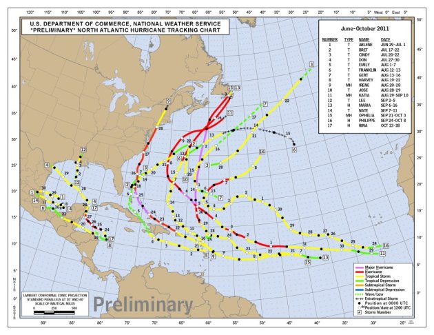
* Dr. Jeff Masters has a comprehensive article listing all 14 billion dollar disasters in 2011 (a new record) here.
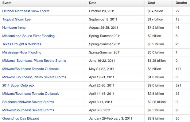
14 Billion Dollar Disasters. The October 29 "Snow-tober" event was the 14th billion dollar weather disaster in 2011. The graphic above is courtesy of Jeff Master's Wunderblog, AON Benfield and NCDC.
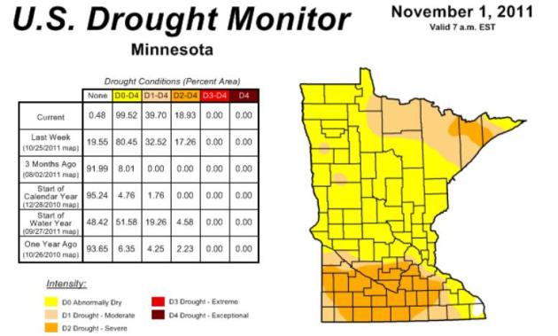
Drought Continues To Develop In Southern Minnesota. According to NOAA's Drought Monitor more than 99% of Minnesota is "abnormally dry" and 40% of the state is in a moderate drought. The situation is getting wworse, especially south/west of the Twin Cities. We need a few good, long, soaking rainfalls - before the ground freezes up solid by late November. Here's more from Mark Seeley in this week's WeatherTalk blog: "Many Minnesota weather observers in southern counties are reporting large precipitation deficiencies since July. In fact the USA Drought Monitor shows that across southern Minnesota, from Lincoln County eastward to Goodhue County and from the Iowa border north to McLeod County much of the landscape is in moderate to severe drought, especially portions of Watonwan and Martin Counties. Many observers in southwestern and south-central Minnesota have reported their driest August through October period in history. Some of the locations reporting the least amount of rainfall over this 3-month period include: 1.93 inches at Winnebago; 1.03 inches at Marshall; 1.85 inches at Worthington; 1.35 inches at St Peter; 1.41 inches at St James; 1.30 inches at Lamberton; 1.28 inches at Windom; 1.65 inches at Fairmont; and 1.59 inches at Canby."
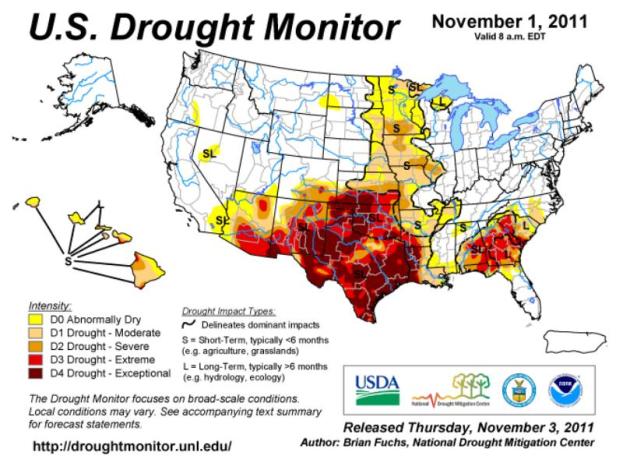
National Conditions. The drought has eased over central and southern Florida, but exceptional drought continues to grip a huge swatch of real estate from New Mexico, Texas and Oklahoma into western Louisiana, and much of the southeast. More from NOAA's Drought Monitor here.

Lake Effect On The Great Salt Lake? I can't remember the last time I've seen this, snow bands setting up over Salt Lake, with a good explanation from the SLC National Weather Service.
.
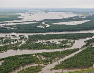
Corp Pledges To Use Lessons From Flooding. It was a humbling summer for people living along the Missouri River and it's tributaries - as well as the Army Corp of Engineers. The Yankton Press and Dakotan explains what was learned from this summer's record floods: “No manual told you to do this to us,” said one woman, referring to the Corps’ master manual for operating the Missouri River. Farhat emphasized the Corps could not foresee the torrential rains in the upper basin that led to the record releases from the mainstem dams. The 160,000 cubic feet per second at Gavins Point Dam near Yankton and Fort Randall Dam at Pickstown more than doubled the dams’ old records. “You have our heartfelt condolences for your losses and the sacrifices that you lived through all summer,” Farhat told the audience. Those remarks were echoed by Brigadier General John McMahon, the Corps’ Northwestern Division Commander. “This was a very regrettable and unfortunate event,” he told the audience. “You have to know we are sincerely sorry for what you have been through.” During Thursday’s meeting, dozens of flood victims urged the Corps to change its plan and release more water to head off a repeat of this summer’s disasters." (photo above: northjersey.com).
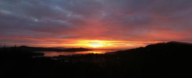
360 Panorama. Check out this cool sunset from Lee Smith in California using a tool that allows you to see a 360 degree panorama of the scene from 360 Panorama. These guys just took sunrises and sunsets to the next level.

Knowing Our Limits
Could Minnesota see another Armistice Day blizzard or Fridley tornado outbreak with little or no warning? Probably not. There's too much technology, a 24/7 news cycle - scores of meteorologists in Minnesota fixated on what comes next. TV news updates have given way to customized e-mail alerts, web maps and GPS-centric apps. We live in an on-demand weather world. One caveat: the historic October 29 "Snow-tober" storm that paralyzed much of New England showed up on weather models only 24-36 hours before the flakes began to fly. In contrast, I got a jump on last December's 17" snowfall about 5 days before the metro area got hammered. The truth: every storm is different. We'll still bust the 7-Day, but the odds of being totally surprised by a deadly storm are mercifully small.
Climate Stories...
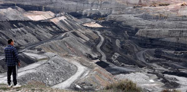
Why North Dakota Is Really Suing Minnesota. Michael Noble has an interesting post for Fresh Energy: "After four years of threatening to sue Minnesota over its climate change policies, North Dakota finally did. First thing you should notice: it’s North Dakota’s lignite coal industry, electric companies, and their trade association who are suing Minnesota, and the state is the front man. You see, John Dwyer, the president of North Dakota’s coal industry council for the past 30 years, is more powerful than any governor or attorney general. He’s outlasted a bunch of them, and according to long-time observers of Bismarck politics, he calls the shots on utility matters The coal industry’s argument is very simple: by placing restrictions on the burning or importing of additional coal in the electric sector, Minnesota is both discriminating against North Dakota and violating the Commerce Clause of the U.S. Constitution. The North Dakota litany of grievances is outlined in this fact sheet."
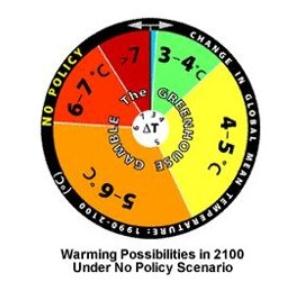
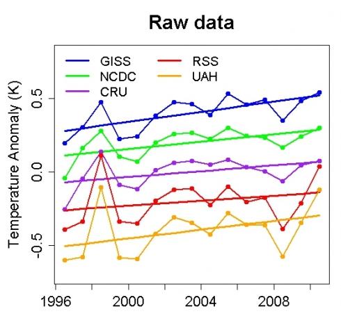
These findings are consistent with those from other authoritative scientific assessments:
- In 2009, the U.S. Climate Change Science Program, which is sponsored by 13 federal government agencies in the United States, issued an assessment concluding that human activities have likely been contributing to warmer nights, heat waves, and heavy downpours. They also warned that drought in the American Southwest is likely to worsen in a warming world, with severe implications for water availability and wildfires.
- In 2011, a climate science assessment by the U.S. National Academy of Sciences reached the same conclusions, noting that the U.S. has been no exception to these global trends.
- The IPCC’s Fourth Assessment Report has also determined that there has been an increase in extreme weather events such as heat waves, intense rainfall events, and category 4 and 5 storms, as well as drying trends across much of the northern and southern hemispheres.."