Good Luck Out There. This will be one of the mildest Deer Hunting Firearm Openers in recent memory, highs in the 50s, topping 60 over parts of southern Minnesota. Sun fades behind increasing high clouds - the big story will be the wind, gusting into the 30-40 mph range at times.
Wind Advisory posted for much of central and southwestern Minnesota. Details below.
Wisconsin Snowfall Next Week? GFS, European (ECMWF) and Canadian (GEM) weather models keep the heaviest precipitation just east of Minnesota next week, a southern storm pushing a period of rain changing to snow from eastern Iowa across central and northern Wisconsin. Right now it looks like a potential snow-maker for Rhinelander, Oshkosh, Tomah, even the Wisconsin Dells, with some slush over far southeastern Minnesota. It's still too early, confidence levels are low.
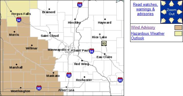
Wind Advisory In Effect. Details from the local Twin Cities National Weather Service office:
...WIND ADVISORY REMAINS IN EFFECT FROM 11 AM TO 7 PM CDT
SATURDAY...

A WIND ADVISORY REMAINS IN EFFECT FROM 11 AM TO 7 PM CDT
SATURDAY.

* TIMING...LATE SATURDAY MORNING AND THROUGH THE AFTERNOON. THE
  WIND SHOULD BEGIN TO TAPER OFF EARLY SATURDAY EVENING.

* WINDS...SOUTH WINDS AROUND 30 MPH WITH GUSTS AROUND 45 MPH.

* IMPACTS...VEHICLES MAY HAVE A DIFFICULT TIME...ESPECIALLY
  THOSE DRIVING EAST OR WEST. BOATERS SHOULD BE VERY CAREFUL
  SINCE WAVES COULD GET RATHER CHOPPY.

PRECAUTIONARY/PREPAREDNESS ACTIONS...

A WIND ADVISORY MEANS THAT WINDS OF AT LEAST 30 MPH ARE EXPECTED.
WINDS THIS STRONG CAN MAKE DRIVING DIFFICULT...ESPECIALLY FOR
HIGH PROFILE VEHICLES. USE EXTRA CAUTION. BOATERS MAY NEED TO
POSTPONE ACTIVITIES OR MOVE TO SHELTERED WATERS.
Minnesota Deer Hunting Opener. The Minnesota State Climatology Office has some interesting weather factoids about weather on the deer hunting firearm opener: "Minnesota's 2011 Firearm Deer Hunting Opener is Saturday, November 5. The normal high temperature for November 5 ranges from the upper 30s across northern Minnesota to the upper 40s near the Iowa border. The average low temperature is in the 20s. The historical probability of receiving measurable precipitation on November 5 is approximately 25%. Early November precipitation often falls as snow in the north, while rain is more likely in the south. An enduring, winter-long snow cover is typically not established until later in November, even in northern Minnesota. The 2010 Firearm Deer Hunting Opener on November 6 was quite mild and mostly dry throughout Minnesota. High temperatures were generally in the mid to upper 50's with lows in the mid 20's to around 30."
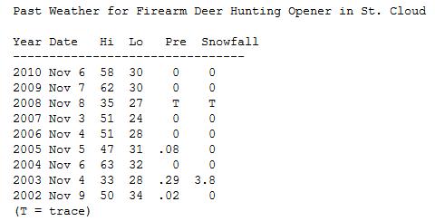
St. Cloud Data. It has snowed only 2 of the last 9 Deer Hunting Openers in the St. Cloud area, a whopping 3.8" snow on November 4, 2003 in St. Cloud. The last 2 years have been quite mild, with a high of 62 in 2009 and 58 last year. Data courtesy of the MN State Climate Office.
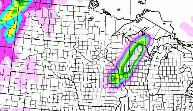
Close Encounter Next Tuesday? The GFS model tracks a significant storm just south and east of MSP next week, enough cold air drawn into the strengthening low pressure system for a stripe of heavy (6"+) snowfall amounts over central Wisconsin, maybe a couple inches for far southeastern MN, closer to La Crosse. Again, it's still too early to deliver a forecast with any kind of confidence. If you're traveling next week, especially south/east of the metro area, you'll want to check in for updates.
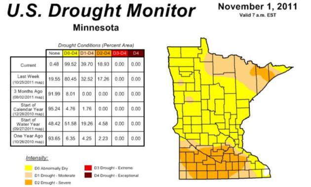
Drought Continues To Develop In Southern Minnesota. According to NOAA's Drought Monitor more than 99% of Minnesota is "abnormally dry" and 40% of the state is in a moderate drought. The situation is getting wworse, especially south/west of the Twin Cities. We need a few good, long, soaking rainfalls - before the ground freezes up solid by late November. Here's more from Mark Seeley in this week's WeatherTalk blog: "Many Minnesota weather observers in southern counties are reporting large precipitation deficiencies since July. In fact the USA Drought Monitor shows that across southern Minnesota, from Lincoln County eastward to Goodhue County and from the Iowa border north to McLeod County much of the landscape is in moderate to severe drought, especially portions of Watonwan and Martin Counties. Many observers in southwestern and south-central Minnesota have reported their driest August through October period in history. Some of the locations reporting the least amount of rainfall over this 3-month period include: 1.93 inches at Winnebago; 1.03 inches at Marshall; 1.85 inches at Worthington; 1.35 inches at St Peter; 1.41 inches at St James; 1.30 inches at Lamberton; 1.28 inches at Windom; 1.65 inches at Fairmont; and 1.59 inches at Canby."
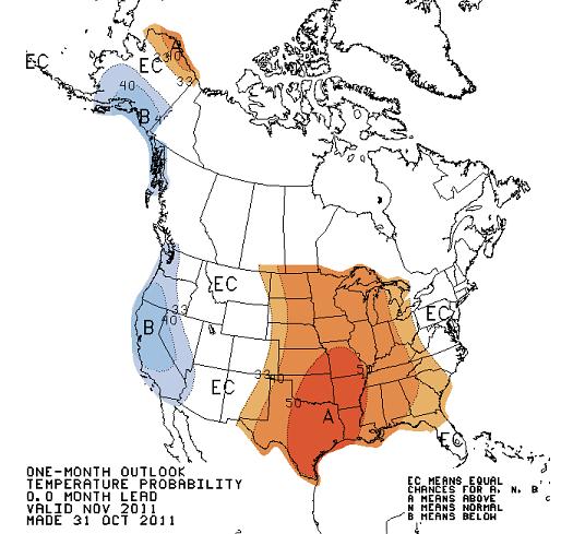
November Outlook. According to CPC (Climate Prediction Center) there's a pretty good chance the month of November will wind up milder than average for the nation's mid-section, from the Rockies to the Great Lakes and Mid South, a cold bias for the far western USA. Looking at the maps I tend to agree. The full impact of La Nina may not kick in until December and January.
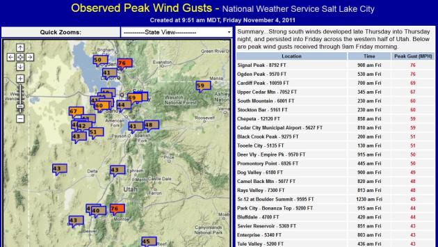
Hurricane-Force Winds Buffet Utah. Check out some of these wind gusts on Friday, as high as 76 mph. at Signal Peak, at an altitude of 8,792 feet. Map courtesy of the Salt Lake NWS.
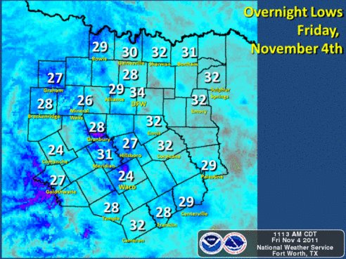
First Freeze For Dallas-Fort Worth. From the DFW NWS Office: “The first freeze of the season hit this morning. The lowest known temperature was 24 at Waco and Comanche. 26 degrees was recorded in Mineral Wells, while 27 and 28 degree readings were common. The temperature dropped to 29 degrees at Alliance Airport in Tarrant/Denton Counties…but most of the metroplex remained above 32 degrees overnight.”
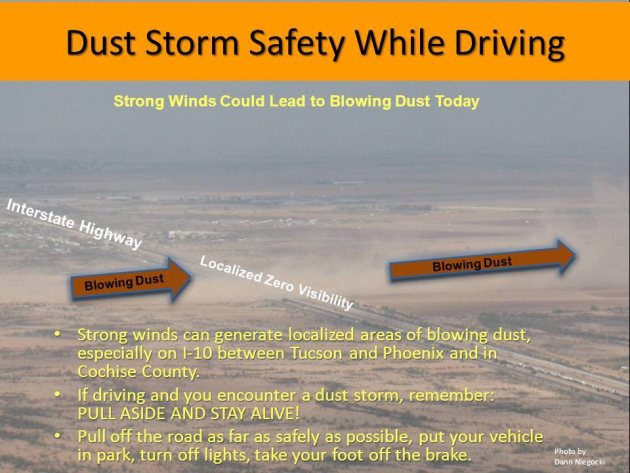
How To (Safely) Drive Through A Dust Storm. I've never seen anything quite like this, courtesy of the Tucson National Weather Service Office. Hey, you never know - parts of Texas are enduring some of the driest conditions since the Dust Bowl of 1936. Drought conditions are growing across Minnesota. With any luck we won't have to drive through any dust storms anytime soon, but just in case....
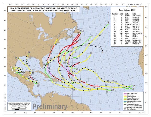
2011 Hurricane Season. 17 named storms - an impressive hurricane season. Of course the big stories were Hurricane Irene and Tropical Storm Lee. Click here to see the tracks, courtesy of NHC.
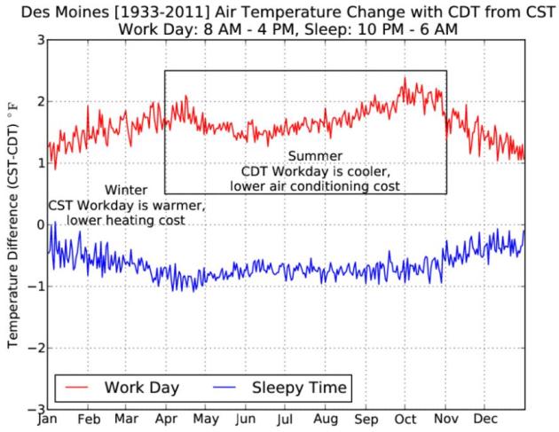
Tin Foil Hat Time. Is DST, Daylight Saving Time, a conspiracy of sorts? Here's an interesting post from the Iowa Environmental Mesonet: "The sham that is daylight saving time ends this weekend and so to encourage those who wear tin foil hats, the featured chart is presented comparing two periods of the day computed in CST and CDT....From an energy perspective, the result is potentially favorable for businesses to save a bit on cooling in the summertime and heating in the winter time. It is a conspiracy! Of course, when we are at home, the effect is reversed, so we have slightly warmer sleeping periods in the summer with CDT and cooler sleeping periods in the winter with CST. Your head is probably spinning trying to follow the logic presented, but think how CDT shifts the work day into earlier in the day to leave more light at night and time for lawyers to golf after work (net cooler, less cooling bill)."
Bad Idea. Please don't try this at home.
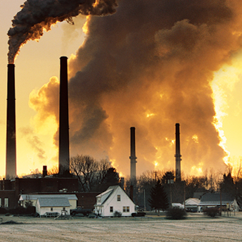
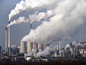
"Clean Coal"
North Dakota is suing Minnesota, claiming our Next Generation Energy Act limiting carbon emissions from power generated outside the state (from burning coal) is unconstitutional. Curious timing: 2010 saw the largest increase in greenhouse gases ever observed worldwide; a 6% increase from 2009 to 2010, or 564 million tons. "From an emissions standpoint, the global financial crisis seems to be over" said Energy Department's Tim Boden in a USA Today article.
Coincidence? Record drought, 1 in 100 year storms every 3 years, an April record for tornadoes (748 in one month) - now a freakish, historic snowstorm in the northeast that took a bigger toll on the electrical grid than Hurricane Irene. Turns out a 4% increase in water vapor is spiking both summer and winter storms.
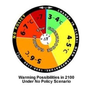
Global CO2 Emissions Rising Faster Than Worst-Case Scenarios. From the Washington Post: "One of the small consolations of the Great Recessions was that global greenhouse-gas emissions had dipped slightly, giving the world a few years’ breathing room to figure out how to tackle global warming. But the Copenhagen climate talks fizzled, the world didn’t take advantage of the lull, and the grace period’s now over. According to new data from the Department of Energy’s Oak Ridge National Lab, global carbon-dioxide emissions just saw their biggest one-year rise, a 6 percent jump in 2010. The striking thing is that emissions are now rising faster than the worst-case scenarios envisioned by the IPCC in its 2007 report. What would this mean for global warming? The chart (above), from a 2009 study by MIT’s Joint Program on the Science and Policy of Climate Change, lays out the possibilities. If emissions keep growing at their current pace, then the average prediction from MIT’s modeling is that the world could heat up 5.2°C by 2100. But that’s just the average. There’s a 9 percent chance that global surface temperatures could rise more than 7°C — truly uncharted territory. And as we keep adding carbon-dioxide into the air, the odds that we’ll be able to dodge a drastic rise in temperatures become very, very low."
IPCC Report Adds To Studies Tying Climate Change To Extreme Weather. WRI Insights has an overview of the IPCC report that is about to be released: "According to media coverage, the forthcoming “Special Report on Managing the Risks of Extreme Events and Disasters to Advance Climate Change Adaptation” warns that a warmer world will likely lead to disruptive changes in the frequency and magnitude of extreme events, such as wildfires, heat waves and cyclones.
These findings are consistent with those from other authoritative scientific assessments:
- In 2009, the U.S. Climate Change Science Program, which is sponsored by 13 federal government agencies in the United States, issued an assessment concluding that human activities have likely been contributing to warmer nights, heat waves, and heavy downpours. They also warned that drought in the American Southwest is likely to worsen in a warming world, with severe implications for water availability and wildfires.
- In 2011, a climate science assessment by the U.S. National Academy of Sciences reached the same conclusions, noting that the U.S. has been no exception to these global trends.
- The IPCC’s Fourth Assessment Report has also determined that there has been an increase in extreme weather events such as heat waves, intense rainfall events, and category 4 and 5 storms, as well as drying trends across much of the northern and southern hemispheres.."
Eye Of The Storm. The Daily Beast focuses in on climate change; how women worldwide are more apt to be impacted than men: "The past decade has seen natural disasters on an unprecedented scale: “Hundred-year” floods are hitting Western Europe and India every two or three years; hurricane and tornadoes of extraordinary strength are ravaging every continent; agriculture systems from Somalia to Texas are collapsing under the assault of unrelenting drought. But what is lesser known is how the effects of these environmental catastrophes—whether sudden or slow-moving—are disproportionately borne by women. Disaster is seldom gender-neutral. The gap is easiest to see in the most acute disasters. In the 2004 Southeast Asia tsunami, death rates for women across the region averaged three to four times that of men. That’s in part because girls and women, per tradition, were less likely to have been taught how to swim. Also, many lacked the upper body strength necessary to climb to safety or cling to a tree; and, most tragically, in a fast-moving storm surge, mothers who stopped to find and gather up children or other dependents lost valuable time, which in some cases meant the difference between life and death."
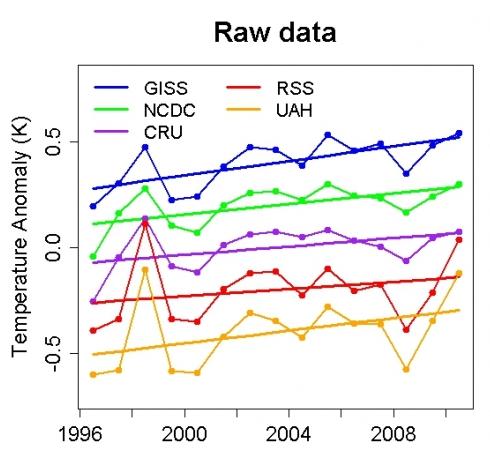
Dr. Muller's Findings. Here's an Op-Ed in the New York Times: "Richard Muller, a prominent American physicist, was so skeptical about data showing a gradual warming of the Earth’s surface that he decided to investigate for himself. The results of his two-year inquiry — partially bankrolled by the Charles Koch Foundation, whose founder is a prominent global-warming denier — are now in. And, voilà, the Earth is indeed warming, just as most scientists have been saying for years. The main finding by Mr. Muller and his team at the University of California at Berkeley is that land temperatures have risen about 1 degree Celsius (or 1.8 degrees Fahrenheit) since 1950. This matches findings by the National Academy of Sciences, federal agencies and independent American and British researchers whose work has been repeatedly attacked by climate deniers and opponents of efforts to limit emissions of greenhouse gases."