First snow flurries for Chicago. 1:50 pm Wednesday:
snow flurries were spotted at O'Hare Airport in Chicago, according to WGN's Chief Meteorologist Tom Skilling.
3.7" snow in Des Moines Wednesday; 5th highest snowfall so early in the season.
943 mb: Alaskan super-storm had a central pressure of 27.85" of mercury midday Wednesday, lower than some Category 4 hurricanes.
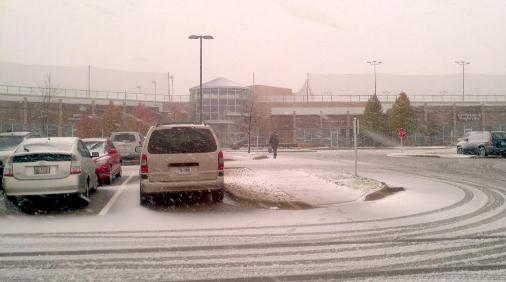
Madison Snow. "Amy Barilleaux took this picture of her gym’s parking lot in Madison, Wisconsin.
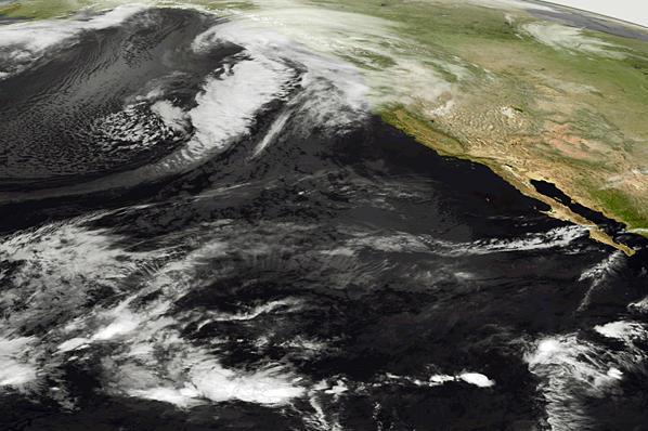
Iowa Snow From Space. Check out the high-resolution visible satellite image: you can tell the difference between clouds over eastern Iowa and Wisconsin (different texture)) than the stripe of snowcover over central and southwestern Iowa (if you look carefully you can see river valleys). From the Des Moines National Weather Service: “
Visible satellite image today, November 9, 2011 showing a narrow snow band of 2 to 6 inches fell overnight. Note the clouds still exiting the eastern portion of the state.”
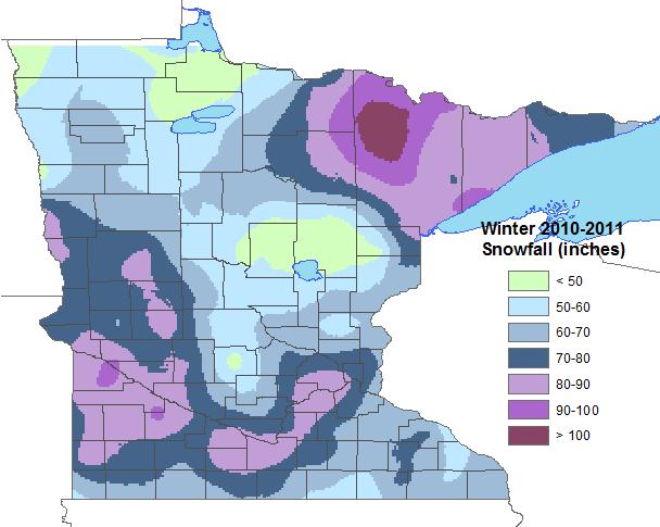 The Amazing Winter of 2010-2011
. 86.6" snow in the Twin Cities last winter, the 4th greatest amount on record. The southern suburbs of the Twin Cities saw the most snow, over 80", with considerably less over the far northern suburbs to St. Cloud to the Mille Lacs area. Over 100" fell on the Iron Range. Map courtesy of NOAA.
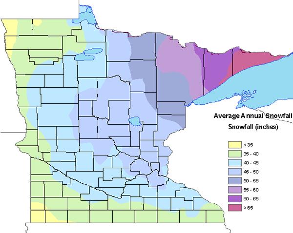 Average Snowfall.
 So here's a question:
if you have one foot in ice water and the other foot in boiling water, do you feel average? It seems like that's often the story in Minnesota, we zig and zag fro one extreme to another. The term "average" is irrelevant in some respects. "Average snowfall" at MSP
is about 54", which is higher than it was 20-30 years ago. We're seeing more snow across Minnesota, but milder winter temperatures mean it's melting faster, it's not the reliable snowcover we experienced a generation ago.
This is Winter Hazard Awareness Week in Minnesota. Here are some
timely reminders:
Winter Weather Preparations
- Keep ahead of the winter storm by listening for the latest weather statements, watches and warnings.
- Your vehicle should also be ready. Get it winterized, before the onset of winter weather.
- Be equipped for the worst. Carry a winter survival kit in your car, especially when traveling in rural or open areas. Try to travel with others.
When Driving
- Yield to snowplows, and give them plenty of room to operate.
- If your vehicle becomes stranded, stay with it until help arrives.
- Do not try to walk for help during a blizzard, you could easily become lost in the whiteout conditions.
Outdoor Activities
- If you will be outside during storms or extreme cold, dress in layered clothing and avoid overexertion.
- Do not kill yourself shoveling snow. Shoveling is very hard work and may induce a heart attack.
- If you will be snowmobiling, avoid alcohol. Most snowmobile deaths are alcohol related. Take a snowmobile course offered by the DNR or check with your snowmobile dealer.
- Every year, there are fatalities in Minnesota when people fall through thin ice.
Home Safety
- Heating fires are a major cause of residential fires in Minnesota. Turn off portable heating devices when you are away from home or retire for the evening. Have your fireplace and chimney professionally inspected before winter.
- Carbon Monoxide is most likely to accumulate inside homes during winter. Check your heating systems and ensure your home has proper ventilation. Install a UL listed Carbon Monoxide detector that sounds an alarm.
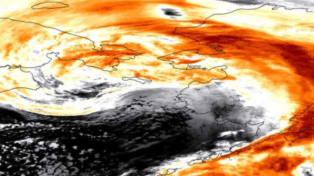
Alaskan Storm From Space.The latest from
NOAA: "
Several images show the storm moving over the Bering Strait region, bringing heavy winds and flooding to western Alaska. The first is a colorized infrared image from the NOAA AVHRR sensor on-board the Metop-A satellite taken on November 9th at 0710z. The second is a composite of GOES-West and MTSAT infrared imagery taken on November 9th at 0z."
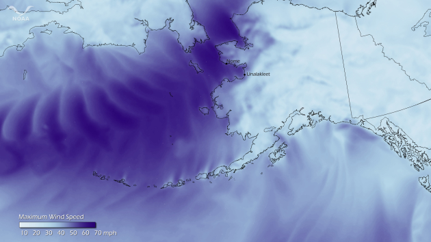
"Inland Hurricane". This image, produced by the NOAA Environmental Visualization Laboratory, shows predicted maximum sustained wind speeds for November 8-9, 2011, from the NOAA North America Model. The storm is creating a life-threatening situation for a large portion of the western Alaska coast today, especially in the Seward Peninsula near Nome, which is getting hit hard by blizzard conditions and 70 mph winds, along with 8-foot coastal storm surge.
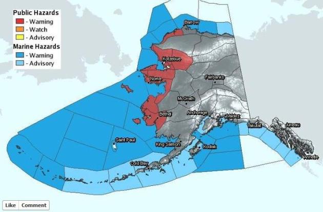 Warnings
. From the National Weather Service
Facebook site: "
Even though skies may be partially clearing on the back side of this dangerous storm, additional coastal flooding is still expected and/or is still occurring. You can find updated warnings/statements as well as the latest forecasts by visiting http://www.arh.noaa.gov/."
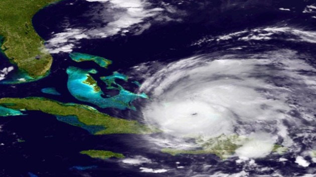
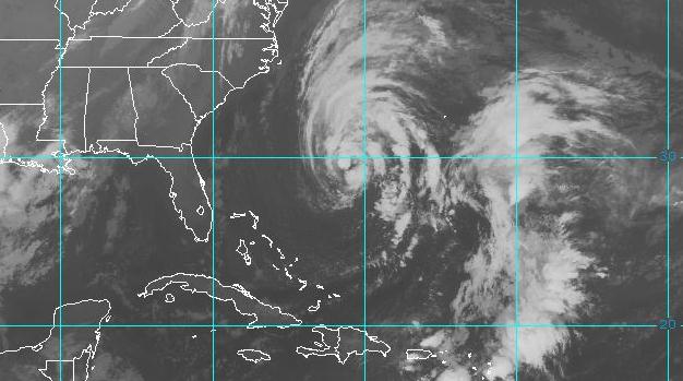 Tropical Storm Sean
. With sustained winds of 65 mph Sean is carving out some 15 foot seas south/west of Bermuda. The storm may strengthen to hurricane status on Thursday.
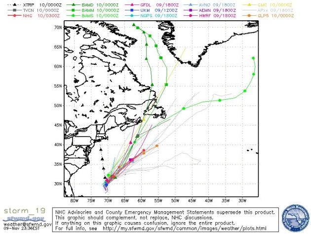 Sean's Track
. The models all agree that Sean will track to the north/northeast, brushing the Canadian Maritimes.
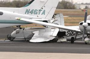
Thunderstorms Flood Oklahoma Roads, Damage Norman Airport. NewsOK.com, powered by The Oklahoman, has the details: "
A tornado that killed at least 100 calves in western Tillman County on Monday was an EF2, the National Weather Service said Tuesday.....Heavy rain also moved through Oklahoma on Monday, causing damage to the University of Oklahoma Max Westheimer Airport and flooding roads across the state. A number of intersections across the Oklahoma City area were closed because of high water from overnight rains. Rick Smith, National Weather Service meteorologist in Norman, said a microburst, which is an intense downdraft, hit Max Westheimer Airport in Norman about 11 p.m. Monday. Tuesday, University of Oklahoma aviation students were helping with the cleanup. Two badly damaged planes were visible on the tarmac, including one that was flipped over. Several other planes had less extensive damage. A number of hangar doors were broken apart or blown off their tracks."
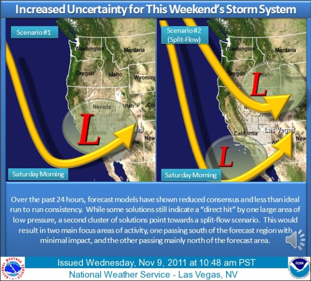
Gambling On A Substantial Storm. From the Las Vegas office of the NWS: "Confidence is increasing that a Pacific Storm with substantial moisture will move into the southern California coast by Saturday morning and bring considerable amounts of rain and snow to the southwest states. Though coastal areas and central Arizona would be favored to see the most precipitation, this storm could bring rainfall amounts up to half an inch across much of the Mojave Desert region and significant snow accumulations to the mountains above 7,000 feet."
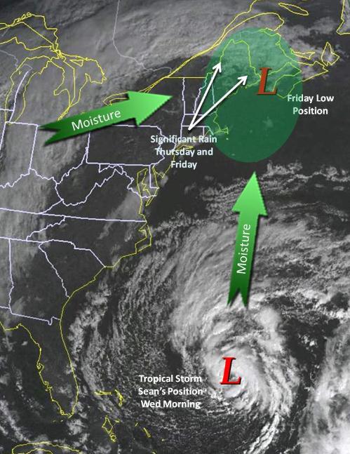
Sean Staying Out At Sea. Residents living up and down the east coast and breathing a big, collective sigh of relief. Tropical Storm Sean is forecast to track to the north/northeast. Here's more from NOAA: "Vermont and northern New York will be spared from the bulk of the moisture expected to stream in ahead of our next storm system and tropical storm Sean. Our expected totals will be around 0.1″ in northern New York to 0.6″ in northeastern Vermont. Towards the end of the event, Mount Mansfield and the higher elevations may see up to 2″ of snow."
Studying Hurricanes' Impact. The University of Virginia's
Cavalier Daily has the story: "
Natural disasters have damaged areas across the United States, and even before Hurricane Irene tracked up and reshaped the Atlantic coast, the National Oceanic and Atmospheric Administration found weather-related losses topping $35 billion. Coastal landscapes often are altered drastically in response to storms like Hurricane Irene, which raise sustainability issues with respect to development. Students and professors across the University’s engineering, architectural and liberal arts colleges are studying coastal processes, their effects and sustainability. University members also are at risk of being affected by these natural events. In August, Engineering graduate student Kristen Cannatelli said she returned home to Rehoboth Beach, Del., for a friend’s wedding, only to find it postponed because of Hurricane Irene. “As far as damages go, more were caused by the tornadoes that came through, than the hurricane and flooding,” Cannatelli said. Hurricane Irene spawned more than 10 tornadoes in Delaware, tearing through 17 homes."
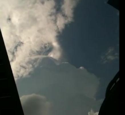
Video Of The Day: "Jumping Sundogs Over Thunderclouds." Every now and then you see something that makes you shake your head. This was one of those moments for me. Here's an explanation (and bizzare video clip) from
NASA: "
What's happening above those clouds? In the past few years, videos have appeared on the web detailing an unusual but little known phenomenon: rapid light changes over clouds. Upon inspection and contemplation, a leading hypothesis for its cause has now emerged. In sum, this hypothesis holds that a lightning discharge in a thundercloud can temporarily change the electric field above the cloud where charged ice crystals were reflecting sunlight. The new electric field quickly re-orients the geometric crystals to a new orientation that reflects sunlight differently. In other words, a lightning discharge can cause a sundog to jump. Soon, the old electric field may be restored, causing the ice crystals to return to their original orientation. To help this curious phenomenon become better studied, sky enthusiasts with similar jumping or dancing sundog videos are encouraged to share them."
 Bering Sea Storm: Has Global Warming Made Alaska More Vulnerable?
 The
Christian Science Monitor has the story: "
A powerful fall storm – the strongest since a mid-November storm in 1974 – is pounding Alaska's west coast with hurricane-force winds and a storm surge that in many places is expected to top eight feet above the high-tide line. Although Alaska's coast is sparsely populated compared with other coastal regions in the US, low-lying areas host a number of native Alaskan villages, as well as the city of Nome. Concerns for flooding and coastal erosion are compounded by a lack of coastal sea ice, which typically extends from the shoreline out toward the open ocean and is building at this time of year. "There's not a lot of shore-fast ice yet," says Scott Berg, a meteorologist with the National Weather Service forecast office in Fairbanks. "This year it hasn't developed quite as extensively as it normally does." This shore-fast ice, which builds in bays along the coast north of Nome, typically represents a first line of defense against coastal flooding when storms plow into the state's coastline. It reduces storm surge. With this storm, however, less-extensive shore-fast ice leaves it vulnerable to the storm surge, Mr. Berg says. The surge likely would carry any available sheets of ice inland to act as a frigid battering ram against structures in its path."
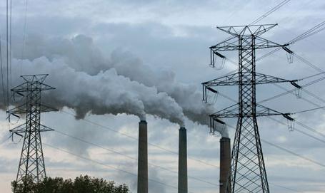
World Headed For Irreversible Climate Change In Five Years, IEA Warns. The story from
The Guardian: "
The world is likely to build so many new fossil-fuelled power stations, energy-guzzling factories and inefficient buildings in the next five years that it will become impossible to hold global warming to safe levels, and the last chance of combating dangerous climate change will be "lost for ever", according to the most thorough analysis yet of world energy infrastructure. Anything built from now on that produces carbon will continue to do so for decades to come, and this "lock-in" effect will be the single factor most likely to produce irreversible climate change, the world's foremost authority on energy economics has found. If this infrastructure is not rapidly changed within the next five years, the results are likely to be disastrous. "The door is closing," Fatih Birol, chief economist at the International Energy Agency (IEA), told the Guardian. "I am very worried – if we don't change direction now on how we use energy, we will end up beyond what scientists tell us is the minimum [for safety]. The door will be closed forever."
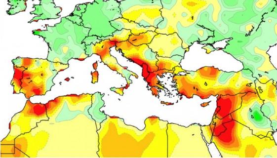
Wintertime Droughts Increase Due To Climate Change. Green Prophet has the story: "
Over the last 20 years, 10 of the driest winters have taken place in the Mediterranean region that stretches from Gibraltar to the Middle East. As the region accumulates most of its precipitation during the wintertime, an increased dryness during this season is particularly worrying. According to scientist, this emerging trend may have a significant impact on water resources and food security in the future. Scientists at the Cooperative Institute for Research in Environmental Sciences (CIRES) published a report in the Journal of Climate stating that the magnitude and frequency of the drying in the Mediterranean region is “too great to be explained by natural variability.” The researchers discovered a pattern of increased wintertime droughts and attributed around half of the drying to climate change caused by the burning of fossil fuels and other human activities. They found that greenhouse gases are warming tropical oceans more than other ocean regions and this is pushing drought-conductive weather patterns in the Mediterranean."
 IBM Yellowstone Supercomputer To Study Climate Change
.
Information Week has the details: "
IBM will build a 1.6-petaflop high-performance computer for the National Center for Atmospheric Research to inaugurate a new supercomputing facility and help the center engage in atmospheric and climate-change research. The system, called Yellowstone, will run on an IBM iDataPlex and should be finished by early next year, according to agency. Researchers will test Yellowstone before it becomes available for research next summer, according to NCAR. The Wall Street Journal said IBM beat three other vendors for the contract, which is valued between $25 million and $35 million. The system will run on Intel Sandy Bridge EP processors and includes a Mellanox high-speed InfiniBand network. In additional to its peak computational rate of 1.6 petaflops, Yellowstone also will have 149.2 TB of memory and 74,592 processor cores. Additionally, its central file system will have 17 PB of usable disk space, which is 12 times more than what's available to NCAR researchers today, according to NCAR."