 60 on Saturday?
 With a gusty south/southeast wind (15-30 mph) temperatures may be 10-15 degrees above average statewide, 50s statewide, with some low 60s possible south of the Minnesota River. This may wind up being one of the warmer Minnesota Deer Hunting Openers in recent memory.
 Fall Back 1 Hour Saturday Night
. Heading back to standard time - an extra hour of sleep this weekend. Woo hoo!
First snow event next week? There's a (slight) chance of wet snow next Wednesday night or Thursday morning - latest models take the storm a little too far south and east for any accumulation in the Twin Cities. But it's still early...
30 and 40-degree highs after November 18 or so, based on GFS model guidance.
Close Encounter. From NASA: "
NASA scientists will be tracking asteroid 2005 YU55 with antennas of the agency's Deep Space Network at Goldstone, Calif., as the space rock safely flies past Earth slightly closer than the moon's orbit on Nov. 8. Scientists are treating the flyby of the 1,300-foot-wide (400-meter) asteroid as a science target of opportunity -- allowing instruments on "spacecraft Earth" to scan it during the close pass." Details below.
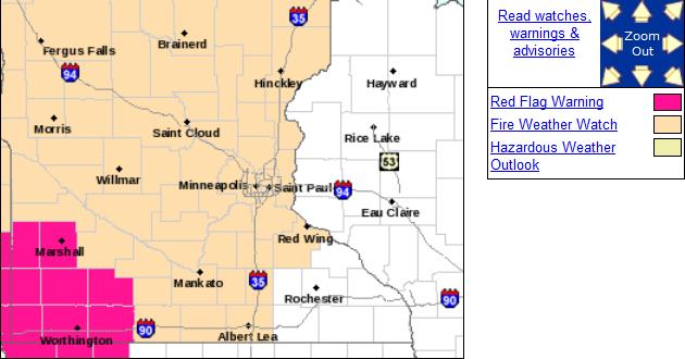 Fire Weather Watch
. A watch means conditions are ripe (for brushfire). Red Flag Warnings are in effect for far southwestern Minnesota, where winds will be strongest - meaning a heightened risk of fire. From the local Twin Cities office of the National Weather Service:
......A FIRE WEATHER WATCH IS IN EFFECT FRIDAY AFTERNOON FOR CENTRAL AND MOST OF SOUTHERN MINNESOTA DUE TO THE COMBINATION OF DRY FINE FUELS...STRONG WINDS...AND LOW RELATIVE HUMIDITY VALUES EXPECTED DURING THIS TIME...
MINNESOTA WILL FIND ITSELF IN BETWEEN A STRONG FALL SYSTEM DEVELOPING IN THE ROCKIES AND AN AREA OF HIGH PRESSURE OFF TO THE EAST TOMORROW AFTERNOON. THE RESULT WILL BE STRONG SOUTHERLY WINDS WHICH WILL STRENGTHEN DURING THE LATE MORNING AND CONTINUE THROUGHOUT THE AFTERNOON. SUSTAINED WINDS BETWEEN 15 AND 25 MPH WITH GUSTS OVER 30 MPH ARE EXPECTED ALONG WITH LOW RELATIVE HUMIDITY VALUES BETWEEN 20% AND 30%. FURTHERMORE...MANY LOCATIONS IN MINNESOTA HAVE RECEIVED ONLY AN INCH OR LESS OF RAIN SINCE SEPTEMBER PRODUCING VERY DRY FINE FUELS. DUE TO THE COMBINATION OF THESE FACTORS...A FIRE WEATHER WATCH IS IN EFFECT FOR FRIDAY AFTERNOON IN CENTRAL AND SOUTHERN MINNESOTA. AFTERNOON TEMPERATURES ARE EXPECTED TO ONLY BE IN THE LOWER TO MID 50S WHICH MAY TEMPER FIRE GROWTH POTENTIAL A BIT. HOWEVER...THE STRONG WINDS AND VERY DRY FUELS ARE ENOUGH TO OVERRIDE THE COOL TEMPERATURES.
THE STRONGEST WINDS WILL BE IN WESTERN MINNESOTA.
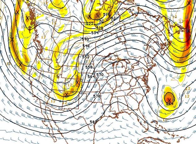
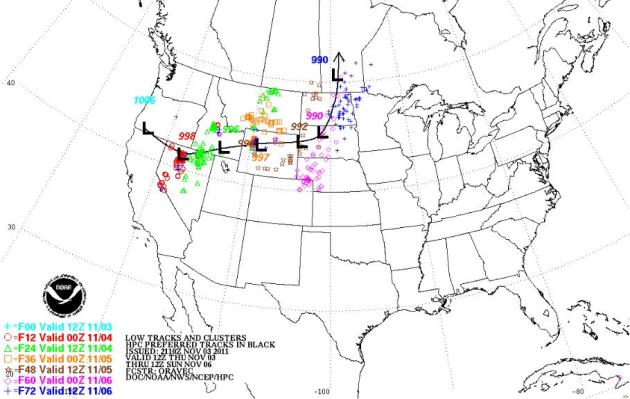 Weekend Storm Track
. The heaviest snows usually fall north/west of the storm track. That will mean significant snow for the northern Rockies extending into the western Dakotas. But a south/southeast flow on the east side of the storm track will mean highs in the 50s and 60s as far north as Minnesota and Wisconsin. Map courtesy of NOAA.
Saturday Winds Aloft. Predicted winds at 500 mb (about 18,000 feet above the ground) show a deep trough of low pressure over the Intermountain West, another stormy surge of energy/moisture diving southeastward toward Los Angeles. Saturday's storm will pass well west of Minnesota, keeping the Twin Cities, Chicago and St. Louis on the warm/eastern side of the storm track, meaning highs in the 50s and 60s, well above average for early November.
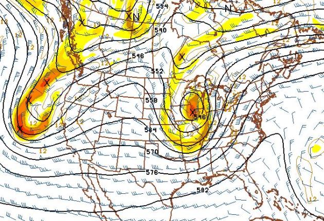 Snow Potential Next Wednesday?
 Here's the latest GFS
model, showing an impressive storm tracking south/east of Minnesota the middle of next week, loaded with moisture from the Gulf of Mexico. It's too early for specifics, but I could envision a cold rain mixing with and even changing over to snow by Wednesday of next week, with the best chance of a sloppy mix coming south and east of MSP.
Stay tuned...
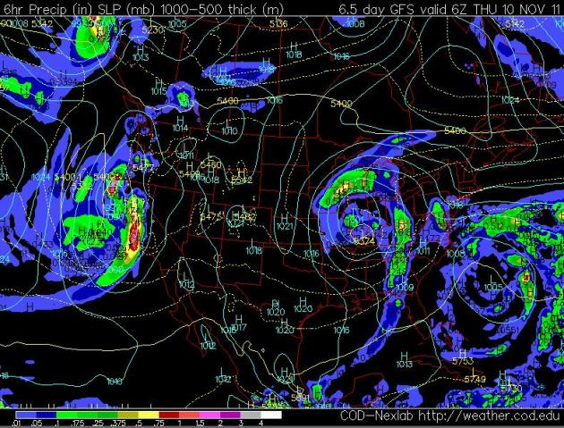 Surface Map: Next Wednesday Night
. The latest models push the storm track farther south and east, just brushing southeastern MN with a cold rain, possibly mixed with wet snow late Wednesday into Thursday morning of next week. Still too early....
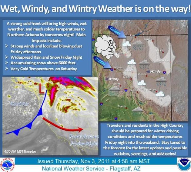
Stormy Spell For The West. Here is information from the Flagstaff office of the National Weather Service - snow is predicted above 6,000 feet.
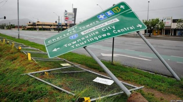
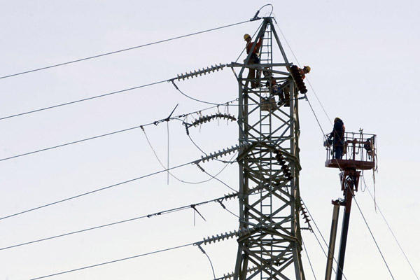
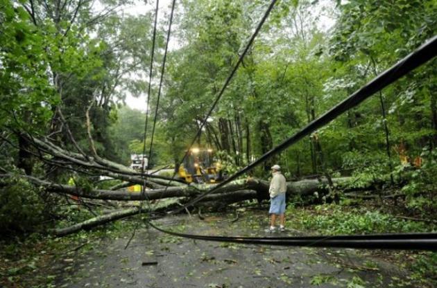
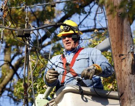
Storm-Downed Power Lines Bring Complaints - And Lessons In Physics Of The Grid. Hundreds of thousands of residents of the northeast (still without power, nearly a week after the freakish "Snow-tober" storm) are rapdily losing their sense of humor, as reported by
The Washington Post: "
NEW YORK — With our wireless Internet connections and far-ranging cell phones, it’s easy to forget the hard-wired electricity that powers our homes and gadgets — until the lights go out. But the freak fall snowstorm that left millions of homes in the Northeast dark this week is delivering a startling reminder of the limits — imposed by both dollars and physics — that keep many Americans reliant on above-ground wires for power, more than a century after Thomas Edison created the modern electrical utility business.
Despite a technological revolution that has transformed the ways people communicate in barely a generation, the mechanics of delivering the electricity that powers all those new devices remains fundamentally unchanged. The outages have ignited anger among some utility customers, many of whom also lost power during Hurricane Irene in August. Some are demanding to know why power providers haven’t spent the money or adapted the technology necessary to prevent such problems."
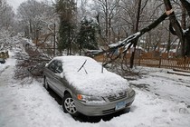
Connecticut Snow Damage Exceeded Hurricane Irene. Strange, but (apparently) true. Here's a story from Bloomberg News and
sfgate.com: "
Damage from an early snowstorm in the Northeast will exceed the costs from Hurricane Irene for the state of Connecticut, as utility crews work to restore power for 99 percent of customers in the next four days. About 538,000 Connecticut homes and businesses remain blacked out today, more than half of the estimated 1.07 million still without electricity across the Northeast four days after the storm, according to data compiled by Bloomberg from utility and state websites. "People's frustration has been mounting," Connecticut Governor Dannel Malloy, a Democrat, said at a press conference today in Hartford. "Mine has been too." Record October snow amounts fell in Hartford and New York City, collapsing trees and branches that hadn't yet shed leaves. More than 3 million customers lost power from the snow, which began Oct. 29 and fell from West Virginia to Maine. Hurricane Irene, which hit the region in August, cut power to an estimated 6.69 million customers." (photo above courtesy of
The Examiner).
Northeast Loses School Days To Irene, Snow. The story from
USA Today: "
HARTFORD, Conn. (AP) – Education officials in the Northeast worried Thursday about having to shorten school vacations to make up for all the days students have missed because of power failures caused by last weekend's snowstorm, combined with days lost to Hurricane Irene at the start of the academic year. Many schools are closed this entire week as crews continue efforts to restore power to about 760,000 utility customers who remain in the dark in several states Thursday. Last weekend's storm dumped an inch to more than 30 inches of wet, heavy snow across the region and took down thousands of trees and wires, cutting power to more than 3 million homes and businesses."
 Power Outage Update
. Here is a state-by-state look, as of Thursday evening, at some of the effects of the late October storm that shocked the Northeast during the weekend with up to 32 inches of snow. About 675,000 homes and businesses still lacked power, and at least 29 deaths, including one in Canada, were blamed on the storm through traffic accidents, electrocutions or other causes. Information courtesy of Chad Merrill at Earth Networks:
CONNECTICUT
About 426,000 customers without power, down from more than 800,000. At least eight deaths reported.
MASSACHUSETTS
More than 140,000 without power, down from more than 670,000.
NEW HAMPSHIRE
About 20,000 without power, down from 315,000.
NEW JERSEY
About 50,000 without power, down from 700,000.
NEW YORK
More than 18,000 without power Wednesday morning, down from more than 300,000.
PENNSYLVANIA
About 21,000 without power, down from about a half-million. At least eight deaths reported.
* photo above courtesy of the Christian Science Monitor.
NASA In Final Preparations For November 8 Asteroid Fly-By. Details from
NASA: "
NASA will start tracking an aircraft carrier sized asteroid with a 70 ft Deep Space network antenna tomorrow at 11:30 CDT and continue tracking it until Nov. 10th. The asteroid, called 2005 YU55, will pass just inside the moon’s orbit, and should have no detectable gravitational impact on Earth. The asteroid orbits around Mars and Venus, and passes this close to Earth every 200 years. The last time an asteroid of this size passed this close to Earth was in 1976, and NASA did not know about it until it had already passed. Another situation similar to this will happen again in 2028."
Uranus Has A Bright New Spot, Picture Shows. National Geographic has more details. "
In a surprise to astronomers, Uranus recently presented onlookers with a new spot on its northern hemisphere. Near-infrared pictures from the 8.1-meter Gemini North Telescope in Hawaii have revealed a region on the giant planet that's much brighter than its surroundings. The spot is likely a tall methane cloud that reaches high enough for us to see sunlight scattered by its icy particles, said Uranus expert Heidi Hammel, executive vice president of the Association of Universities for Research in Astronomy (AURA). The Uranian cloud is probably similar to an anvil cloud, the type of towering cumulonimbus cloud (picture) that's associated with severe thunderstorms on Earth."
Climate Stories...
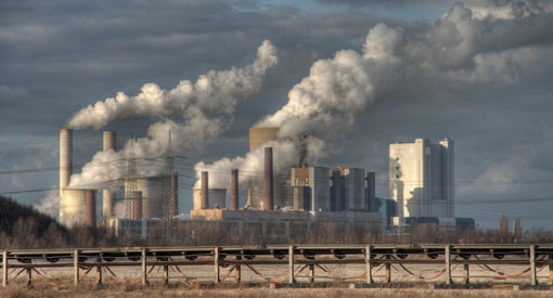
 Biggest Jump Ever Seen In Global Warming Gases.
 The story from
USA Today: "
WASHINGTON – The global output of heat-trapping carbon dioxide jumped by the biggest amount on record, the U.S. Department of Energy calculated, a sign of how feeble the world's efforts are at slowing man-made global warming. The new figures for 2010 mean that levels of greenhouse gases are higher than the worst case scenario outlined by climate experts just four years ago. "The more we talk about the need to control emissions, the more they are growing," said John Reilly, co-director of MIT's Joint Program on the Science and Policy of Global Change. The world pumped about 564 million more tons (512 million metric tons) of carbon into the air in 2010 than it did in 2009. That's an increase of 6%. That amount of extra pollution eclipses the individual emissions of all but three countries — China, the United States and India, the world's top producers of greenhouse gases. It is a "monster" increase that is unheard of, said Gregg Marland, a professor of geology at Appalachian State University, who has helped calculate Department of Energy figures in the past."
North Dakota Sues Minnesota Over Anti-Global Warming Measure.
Bloomberg News has the story: "
Nov. 2 (Bloomberg) -- North Dakota sued Minnesota, claiming the neighboring state’s 2007 law limiting carbon emissions from electricity generated outside Minnesota and used within the state is unconstitutional. “Minnesota’s Next Generation Energy Act has direct and serious consequences for North Dakota,” Attorney General Wayne Stenehjem said today in a press statement announcing his filing with the federal court in St. Paul, Minnesota. North Dakota power plants export most of their generated power to other states, including Minnesota, Stenehjem said. The Minnesota statute unconstitutionally interferes with his state’s energy production, the attorney general said. North Dakota seeks a court order invalidating the measure. Signed by then-Governor Tim Pawlenty in May 2007, the Next Generation act was intended to reduce greenhouse gas emissions while promoting renewable energy sources and greater energy efficiency. “The best time to have taken action on energy issues would’ve been 30 years ago. The second best time is right now,” Pawlenty said then in a press statement." (photo above courtesy of energyresults.com).
* More on the North Dakota lawsuit from
legalnewsline.com.
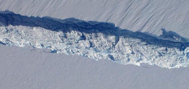
NASA Airborne Mission Maps Remote, Deteriorating Glaciers. Here's a
press release from NASA: "
PUNTA ARENAS, CHILE – NASA's airborne expedition over Antarctica this October and November has measured the change in glaciers vital to sea level rise projections and mapped others rarely traversed by humans. Operation IceBridge, nearing completion of its third year, is the largest airborne campaign ever flown over the world's polar regions. Bridging a gap between two ice elevation mapping satellites, and breaking new scientific ground on its own, IceBridge this fall has charted the continued rapid acceleration and mass loss of Pine Island Glacier. IceBridge has now generated three years of laser altimetry data over certain locations to continue the record from NASA's Ice Climate and Elevation Satellite (ICESat), which stopped operating in 2009. IceBridge measurements show Pine Island following its rapid deterioration that began around 2006. Combined IceBridge and ICESat data show the glacier is losing more than six times as much mass per year -- mass loss was measured at 7 gigatons a year in 2005 and about 46 gigatons a year in 2010 – making it one of the most significant climate change response trends that scientists see worldwide. For comparison, the Chesapeake Bay holds about 70 gigatons of water."
Photo credit above:
"A close-up image of the crack spreading across the ice shelf of Pine Island Glacier shows the details of the boulder-like blocks of ice that fell into the rift when it split. For most of the 18-mile stretch of the crack that NASA’s DC-8 flew over on Oct. 26, 2011, it stretched about 240 feet wide, as roughly seen here. The deepest points ranged from about 165 to 190 feet, roughly equal to the top of the ice shelf down to sea level. Scientists expect the crack to propagate and the ice shelf to calve an iceberg of more than 300 square miles in the coming months. This image was captured by the Digital Mapping System (DMS) aboard the DC-8. Credit: NASA/DMS."
Global Warming To Blame For Extreme Weather: 5 Examples of Bizarre Weather in 2011. The International Business Times has the story: "
A report from top climate scientists warns that such extreme weather like heat waves, floods and droughts will continue to trouble the world and disasters could become even more severe in the next few years. The report from the Intergovernmental Panel for Climate Change (IPCC) will focus on extreme weather phenomenon that has decimated towns and killed thousands of people around the world. "This is the largest effort that has ever been made to assess how extremes are changing," said Neville Nicholls, a professor at Monash University in Melbourne, Australia, and a coordinating lead author of one of the review's key chapters. The draft summary of the report, obtained by the Associated Press, says that climate extremes have worsened because of man-made greenhouse gases. The report concludes that the frequency and magnitude of hot days will increase over the 21st century. It is very likely that heat waves will continue to increase over most land areas. Peak temperatures are likely to increase to 3.0 degrees Celsius by 2050 and 5.0 C by 2100. Droughts will intensify in parts of the globe like North America, northeastern Brazil and southern Africa."


