10.4" snow predicted for Eau Claire, WI by midday tomorrow (NAM model using "Cobb Method").
November 18: average date of the first 1" snowfall in the Twin Cities.
December 20: average date of the first 4" snowfall in the Twin Cities. Source: MN State Climatology Office.
May 2: last trace of snow flurries in the Twin Cities.
Oklahoma Battered By Tornadoes, Hail. Here's the latest from the L.A. Times: "Some residents two miles south of Tipton, Okla., were trapped after their house was damaged by the storms, but they were eventually rescued and were not injured, Tillman County emergency management director Jeffrey Rector told the Associated Press. At about 3 p.m. Central time Monday, storm spotters reported a large tornado south of Tipton, about 130 miles southwest of Oklahoma City, headed toward Snyder. The same tornado apparently touched down in Tillman County, destroying a structure and damaging at least three others, according to KOCO-TV. The tornado weakened before striking Snyder, but additional tornadoes associated with the same storm system have also touched down in the area, the station reported."

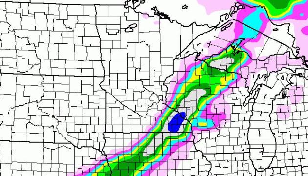

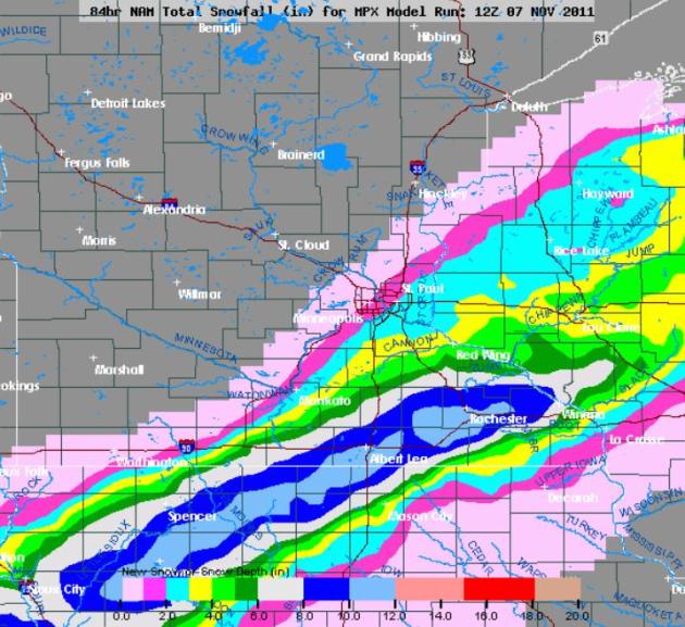
Sharp Cut-Off. Am I nervous? You bet. Models are hinting at 6-10" snow from Albert Lea to Rochester, with less than 1" for the southern suburbs of the Twin Cities. A slight jog to the north/west could push heavier snow amounts into the immediate Twin Cities, but the odds of this happening are small, less than 1 in 4.
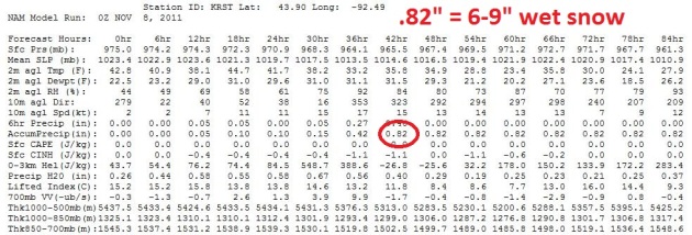
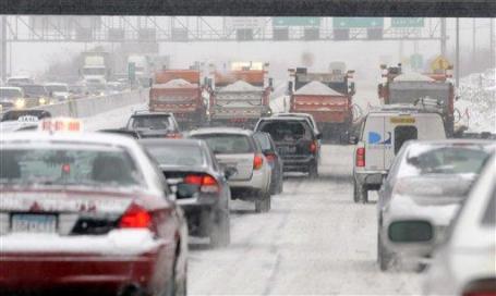
Rochester: Instant Winter. While Twin Cities commuters breathe one big collective sigh of relief (and snow lovers whine), folks in Rochester, Minnesota may get more snow than they bargained for. The latest NAM model prints out .82". A 10:1 ratio seems reasonable, meaning a good chance of 8" snow. Now the ground is relatively mild, some of that snow will melt on contact, but I could still envision a big pile of white by midday Wednesday. The heaviest snows are forecast to come tomorrow morning around breakfast.
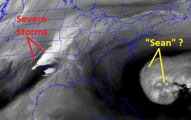
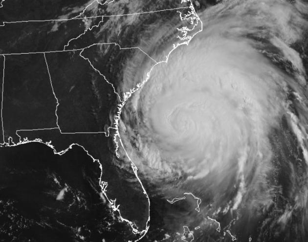
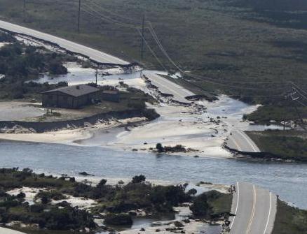
Tropical Storm "Sean"? According to NHC there is a 70% probability an area of disturbed weather off the southeast coast will strengthen to tropical storm status in the next 48 hours. Thankfully, steering winds should nudge "Sean" away from the east coast of the USA.
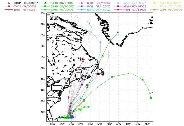
Projected Track. All the models whisk "Sean" to the north/northeast - it may threaten the Canadian Maritimes by Thursday with coastal beach erosion and tropical storm force gusts.

Slushy Possibilities
"Hey Paul, what's the weather?" Let me check the Amish Doppler (window). The truth: with a keen knowledge of clouds, a barometer on the wall and current wind direction, anyone can make a fairly accurate 6-12 hour forecast. Anything beyond that requires weather models. Back in the '70s there was but one model (the LFM, or Limited Fine Mesh). Now there are scores of weather models, each with unique physics. Some work better than others in specific scenarios. This is the black art of weather forecasting today - knowing what weather model to believe, and why.
Climate Stories....
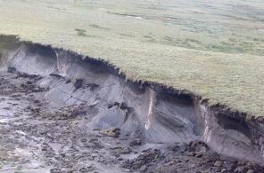
Arctic Permafrost: Climate Wild Card. Here's a vaguely terrifying excerpt of a story from Time: "On the basics, the science of climate change is pretty straightforward. Carbon dioxide released into the air—whether through the burning of fossil fuels, deforestation or other natural causes—adds to the greenhouse effect, which traps more solar energy in the atmosphere and warms the planet. But just how this will happen—how fast and exactly how the planet and the climate will respond to more carbon and more warming—gets very complicated very quickly. There are wild cards in the climate system, some of which—if they flip the wrong way—could vastly accelerate global warming well beyond anything most climate models predict. One of those wild cards is the 1,672 billion tonnes of carbon equivalent trapped in the form of methane in the Arctic permafrost, the soils kept frozen by the far North's extreme temperatures. Methane is a powerful greenhouse gas—it has 20 times the warming effect of carbon dioxide—and the total amount of carbon equivalent in the Arctic permafrost is 250 times greater than annual U.S. greenhouse gas emissions. As the Arctic warms—which it's doing rather rapidly—there's a risk that the permafrost could become less than permanent, releasing some of that trapped methane into the air, which would then accelerate warming, leading to more Arctic melt, more methane emissions...so on and so on. Climate scientists call this a "feedback loop"—and if it happens soon, you could just call us screwed."
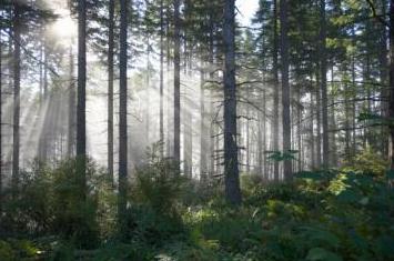
Global Warming Threatens Forests In U.S. West. Here's a good summary from ThirdAge.com: "Global warming and other factors are causing large movements of tree species across the U.S. West, researchers say. With climate change, insect attack, diseases and fire, several tree species are expected to decline and possibly die out in regions where they have lived for centuries while others move in and replace them, researchers at Oregon State University said. Some of the once-common species, such as the lodgepole pine, may be replaced by other trees, perhaps a range expansion of ponderosa pine or Douglas fir, UPI.com reported. Other areas may see a complete shift out of forest into grass savannah or sagebrush desert, researchers said."

Climate Change Affecting Oceans Faster, Study. Australia's ABC Network has the story: "Climate change is having a more pronounced effect on animals and plants in the world's oceans than scientists had previously anticipated, a new analysis shows. Scientists had expected that the effect of climate change would be slower in the oceans than on land, due to the amount of energy it takes to heat such large bodies of water. But after studying the changes in temperature on land and in the oceans over 50 years, researchers led by Michael Burrows from the Scottish Marine Science Institute say this isn't the case. Their calculations of the velocity of climate change and shifts in seasonal timing between 1960 and 2009 appear in today's issue of the journal Science ."