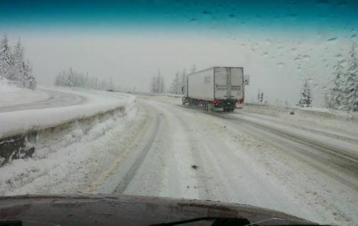
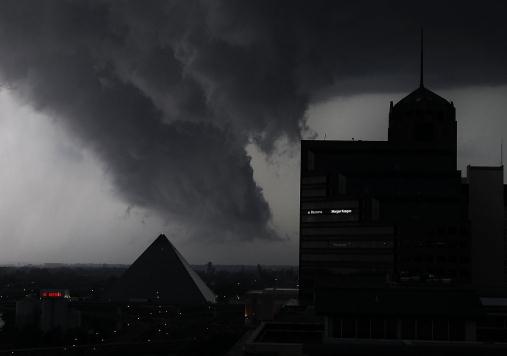
Missoula, Montana. Photo courtesy of WeatherNation.
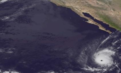
145 mph. Hurricane Kenneth, in the eastern Pacific, grew into a rare Category 4 hurricane. It is now the strongest hurricane ever observed in the eastern Pacific so late in the season.
$9 billion: estimated cost of 2011 Texas heatwave and drought.

"
Even the King of Thailand has created a method of creating and steering rain clouds. Five different technologies, among many others, are presented to control the weather including controlling storms and creating artificial tornadoes and lightning as well as creating and steering rain and snow clouds." - from a fascinating article below on weather control, individuals and businesses patenting ways to nudge the atmosphere in a specific direction.
-30.1 F. average temperature in Fairbanks, Alaska week of Nov. 15-21; the coldest early season week on record. Source: Fairbanks NWS office. 5 days/row of record cold in Fairbanks.
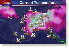
...THE COLDEST EARLY WINTER SEASON WEEK AT FAIRBANKS...

THE PAST WEEK HAS BEEN RECORD SETTING IN MANY WAYS. SIX NEW
RECORD LOW TEMPERATURES AND 4 NEW RECORD LOW MAXIMUM TEMPERATURES
WERE ESTABLISHED. IT WAS THE COLDEST EARLY SEASON WEEK ON RECORD
AT FAIRBANKS. FOR THE PERIOD FROM NOVEMBER 15-21 THE AVERAGE
TEMPERATURE AT THE AIRPORT WAS -30.1 DEGREES. THIS IS THE COLDEST
WEEK DURING THE MONTH OF NOVEMBER SINCE 1930. PRIOR TO 1930...THERE
WERE TWO COLD SNAPS DURING THE LAST WEEK OF NOVEMBER THAT WERE
COLDER. IN 1909 AND 1927 THE AVERAGE TEMPERATURE WAS COLDER...BUT
THESE TWO COLD SNAPS OCCURRED DURING THE LAST 7 DAYS OF THE MONTH
AND DID NOT START AROUND MID-MONTH LIKE OUR CURRENT RECORD
SETTING COLD SNAP.
* Source: Fairbanks office of the National Weather Service.
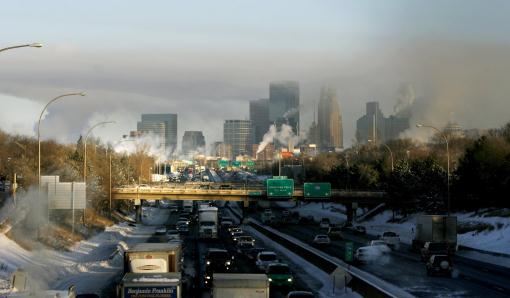
 Thanksgiving 2011: Hints of Indian Summer
. All the models are predicting low to mid 50s tomorrow (assuming we see some sun and a south breeze). The only thing that could keep us in the 40s is lingering fog and stratus. Highs reach 50 on Friday, and then cool down to average levels next week.
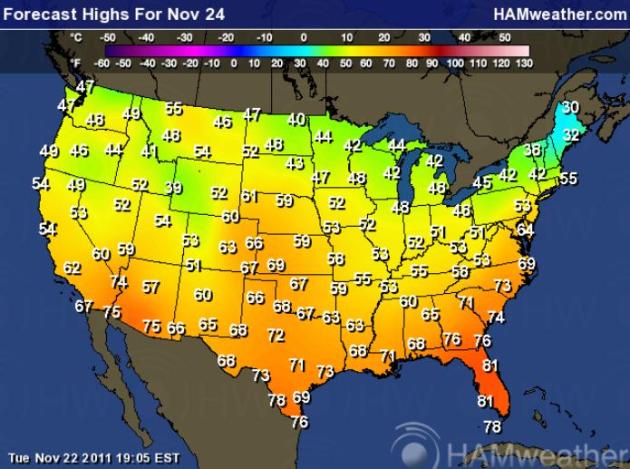 Thanksgiving 2011: Better Than Average
. Much of America will see a warmer-than-average Thanksgiving Day, highs mostly in the 50s and 60s. The only exception: northern New England, still digging out from under a significant snowfall. Map courtesy of Ham Weather.
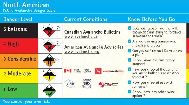
Avalanche Warnings. Back country travel near Mt. Hood is not advised until at least Wednesday afternoon, due to avalanche conditions in the mountainous areas. High winds, coupled with recent unsettled snow, cause strong avalanche conditions. Graphic courtesy of Northwest Weather and Avalanche Center.
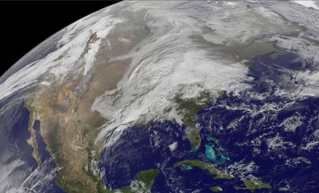
A Tale Of Two Storms. NOAA GOES Satellite imagery shows the storm that spawned severe storms over Alabama Tuesday - destined to dump out some 6-12" snowfall amounts from upstate New York to Maine today. Meanwhile, a second storms is sweeping off the Pacific, pushing high winds, heavy rains and mountain snows into the Pacific Northwest - heading toward California by Thanksgiving Day.
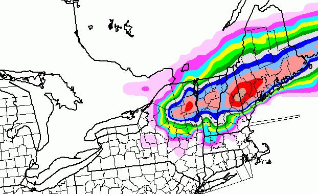
 New England Snowfall.
 The NAM
model is predicting some 8-16" snowfall amounts from the Catskills of upstate New York to North Conway, New Hampshire to Augusta, Maine.
Man-Made Weather? I found this article at
agoracosmopolitan.com to be fascinating and more than a little troubling. There are some people and companies out there patenting unusual ways to "control the weather". Likely within our lifetime? I doubt it, but never say never, right? "
U.S. Patent Application 20100072297 describes a method for controlling hurricanes. According to inventors Manilal J Savla (Manalapan, NJ) and Vishal T. Shah (Parlin, NJ) the method for controlling and steering hurricanes involves raising temperature in the eye and/or in the outflow. Air temperature within the eye and in the outflow of a hurricane is raised by flying scores of jet planes with afterburners in the structure. Small changes in temperature on a large scale bring in large changes in other variables on the smaller scale to change the direction and intensity of the hurricane. The US National Oceanic and Atmospheric Organization and other US agencies fly planes through hurricanes routinely to do research and collect scientific data....In U.S. Patent Application 20110248498, entitled Generating Electrical Power Utilizing Surface-Level Hot Air As The Heat Source, High Atmosphere As The Heat Sink And A Microwave Beam To Initiate And Control Air Updraft, inventor Slobodan Tepic (Zurich, CH) describes a way to create artificial tornadoes The invention uses a renewable source for electricity generation utilizing a solar chimney created by a microwave beam to form an artificial tornado."
Hurricane Kenneth In Eastern Pacific: Record-Setting Category 4 Storm. Jason Samenow at the Washington Post's must-read
Capital Weather Gang web site has the details: "
Hurricane season ends in just over a week, yet one of eastern Pacific’s most intense storms this year swirls over the open ocean. Kenneth strengthened to category 4 intensity this morning, becoming the strongest hurricane on record so late in the season in the eastern north Pacific."
Funding For Hurricane Hunter Flight Program Restored. Folks living along the Atlantic and Gulf coast must be somewhat relieved by this turn of events, as reported by
Tampa Bay Online: "
A proposed $12 million cut to the budget of the Hurricane Hunters flight program at MacDill Air Force Base has been restored in legislation that will be voted on by the House of Representatives next week. The cut would have represented a 40 percent reduction to the program's $29 million budget, according to Rep. Kathy Castor, D-Tampa. The aircraft operations center at MacDill operates two P-3s and a Gulfstream G4 jet. "The Hurricane Hunters provide invaluable information on the track and intensity of tropical storms and hurricanes. Hurricane Hunters save lives and money, and the irresponsible cuts would have dealt a severe blow to accurate predictions and the important missions out of MacDill Air Force Base," Castor, who lobbied for the cuts to be restored, wrote in a letter to congressional leaders." (Photo above courtesy of NOAA).
Naval Research Labs Develops More Accurate Tropical Cyclone Prediction Model.
Democraticunderground.com has the story: "
Researchers at the Naval Research Laboratory Marine Meteorology Division (MMD), Monterey, Calif., have developed the Coupled Ocean/Atmosphere Mesoscale Prediction System Tropical Cyclone (COAMPS-TC™) model, achieving a significant research milestone in predictions of tropical cyclone intensity and structure. While the predictions of the paths or tracks of hurricanes, more generally referred to as tropical cyclones (TC), have steadily improved over the last few decades, improvements in the predictions of storm intensity have proven much more difficult. "Over the past two years, the COAMPS-TC model has shown to be the most accurate emerging research model for predicting tropical cyclone intensity," said Dr. Jim Doyle, research meteorologist, NRL Monterey. "There is no better example of these difficult challenges than the intensity predictions for Hurricane Irene this past August."
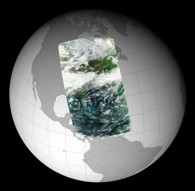 NASA's NPP Satellite Acquires First VIIRS Image
. Some amazing imagery is now aviable from the newest NASA weather and climate satellite. Here's a press release from
NASA: "
GREENBELT, Md. -- The Visible Infrared Imager Radiometer Suite (VIIRS) onboard NASA's newest Earth-observing satellite, NPP, acquired its first measurements on Nov. 21, 2011. This high-resolution image is of a broad swath of Eastern North America from Canada’s Hudson Bay past Florida to the northern coast of Venezuela. The VIIRS data were processed at the NOAA Satellite Operations Facility (NSOF) in Suitland, Md. VIIRS is one of five instruments onboard the National Polar-orbiting Operational Environmental Satellite System Preparatory Project (NPP) satellite that launched from Vandenberg Air Force Base, Calif., on Oct. 28. Since then, NPP reached its final orbit at an altitude of 512 miles (824 kilometers), powered on all instruments and is traveling around the Earth at 16,640 miles an hour (eight kilometers per second). "This image is a next step forward in the success of VIIRS and the NPP mission," said James Gleason, NPP project scientist at NASA's Goddard Space Flight Center, Greenbelt, Md."
Computerized Contact Lens Will Keep You Up To Date With News And Texts. Science fiction? I have a hunch this technology will be commercialized. Just what we need - more digital distractions. The U.K.
Daily Mail has more details: "
Imagine catching up with your texts, social networking and perhaps the news without having to log on to a computer or even glance at a smartphone. Messages and images would simply appear in front of your eyes, generated by a computerized contact lens....The super-lenses are the brainchild of Professor Babak Parviz, a contact lens-wearing engineer who specializes in making parts on the nanoscale, thousands of times thinner than a human hair." (photo: AP-NYT).
If Steve Jobs Ran Your Broadcast Station. Working in the broadcasting world for 30 years I found this a fascinating story. What would Steve do, with threats (and opportunities) in every direction? The broadcasting resource,
Radio and Television Business Report, has the story: "
The story of Steve Jobs is beyond epic. There are not many who could change the world of personal computers, music, phones and animated films in one lifetime. His character DNA was a mix of sheer genius, vision, tenacity and often disturbing habits that easily puts him in the same league as Edison, Ford and Tesla. As I finished the best-selling biography of Steve Jobs by Walter Isaacson, I wondered what would happen if Jobs, with his highly combustible yet potent management style had decided to become the general manager of a TV or Radio station, instead of being the king of Silicon Valley. It’s this kind of hardcore leadership, combined with brutal austerity measures that Broadcasters (and Newspapers) would certainly benefit from today. Introducing someone like this into your operation wouldn’t be easy. But as they say – if you want a great omelet, you have to break a few eggs."
Climate Stories...
The Daily Weather Really Is Getting Weirder.
Time Magazine has the story - here's an excerpt: "
Human beings have notoriously bad memories about weather, like just about everything else. We tend to overemphasize extreme events and downplay the dull normal, which is why your Granddad's stories about walking uphill in the snow, both ways, probably aren't true. But if you think that the daily weather has gotten weirder lately—more extremes and more sudden changes—it turns out you might actually be right. According to a recent study by Princeton University researchers published in the Journal of Climate, extreme sunny or extremely cloudy days are more common now than they were in the early 1980s, and the swing from heavy storms to dry days is also more intense than it was in the late 1990s. Altogether, a third of the planet is experiencing more extreme and erratic variations in day-to-day weather. The weather—not just big storms, but the daily stuff of the evening newscast—really is getting weirder." (AP Photo/Lance Murphey).
Climate Panel Says Prepare For Weird Weather. Nature has the story: "
Extreme weather, such as the 2010 Russian heat wave or the drought in the horn of Africa, will become more frequent and severe as the planet warms, the Intergovernmental Panel on Climate Change (IPCC) warns in a report released today. Some areas could become “increasingly marginal as places to live in", the report concludes. It is “virtually certain” — meaning 99–100% probability in IPCC terminology — that the twenty-first century will see an increase in the frequency and magnitude of warm temperature extremes and a decrease in cold extremes. It is much less clear, however, how climate change will affect rainfall, flood risk and storminess." (Star Tribune photo).
 Media Already Botching Reports On Hacked Climate E-mails
.
Media Matters has the story: "
Earlier today I asked whether American news outlets would do their due diligence in evaluating the content of the newly-released batch of "Climategate" emails hacked from the University of East Anglia two years ago. It didn't take long for our esteemed print outlets to disappoint. Writing on the Washington Post's website, Juliet Eilperin quotes an email exchange that she said was about "whether the IPCC has accurately depicted the temperature rise in the lower atmosphere": In one round of e-mails, researchers discuss whether the IPCC has accurately depicted the temperature rise in the lower atmosphere. An official from the U.K. Met Office, a scientific organization which analyzes the climate, writes to the Climate Research Unit's former director Phil Jones at one point, "Observations do not show rising temperatures throughout the tropical troposphere unless you accept one single study and approach and discount a wealth of others. This is just downright dangerous. We need to communicate the uncertainty and be honest. Phil, hopefully we can find time to discuss these further if necessary [...]"
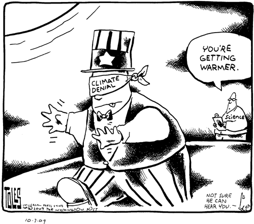
What Are Climate Change Skeptics Still Skeptical About? The sad truth: no amount of evidence will convince some - it's more ideologically-driven than scientifically-driven. Climate change doesn't fit with their world-view.
Live Science poses the rhetorical question: "
Richard Muller used to be a global warming skeptic. A prominent physicist at the University of California, Berkeley, Muller didn't trust the level of rigor — or the results — of past climate studies. As he explained in editorials that were often cited by other skeptics, he thought the dramatic global temperature rise reported by NASA and many other groups may have stemmed from systematic measurement errors rather than an environmental catastrophe. Instead of leaving it at that, Muller founded the Berkeley Earth Surface Temperature (BEST) study in 2010 to do the job right. His team of statisticians, physicists and climate experts conducted an exhaustive analysis of 200 years of global temperature data, running 1.6 billion temperature reports from 39,000 recording stations through a complex process that filtered out questionable data and averaged the rest."
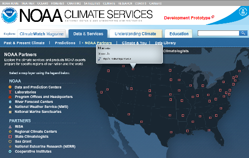
Congress Rejects Request For National Climate Service, A Resource For Climate Change Information. The
International Business Times has the story: "
Congress has successfully barred the National Oceanic and Atmospheric Administration (NOAA) from establishing a comprehensive database on its Web site pertaining to climate information, a seemingly mundane event that is demonstrative of the fight between political parties' to recognize and react to climate change. NOAA reports it has been overwhelmed with requests for information about climate data. Climate-related phone calls and e-mails have shot up from 26,000 to 30,000 between 2009 and 2010, according to The Washington Post, while NOAA says the amount of climate data attributed to its Web site increased by 86 percent during that time period. In early 2010, the Obama administration announced plans to create a separate NOAA Climate Service , an entity that would provide user-friendly information from everything from sea level projections to the best sites for solar and wind power in order to help governments and businesses adapt to climate change. "