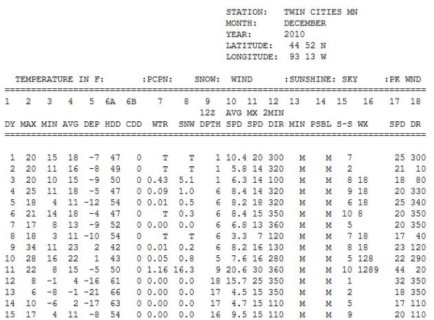
 24.2" snow
 fell on the Twin Cities during the first 15 days of December last year. 16.3" of that was on one day (11th).
0: expected rain/snow over the next 84 hours (NAM model).
72 F. at Newark, New Jersey Monday; this ties the record high for November 28.
3rd busiest hurricane season on record for the Atlantic basin. Details from NOAA below.
19 named tropical storms, 7 hurricanes, 3 of which became major "Category 3" storms.
"
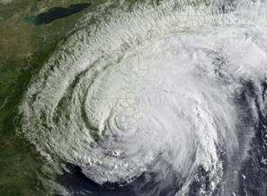
Irene was the lone hurricane to hit the United States in 2011, and the first one to do so since Ike struck southeast Texas in 2008. Irene was also the most significant tropical cyclone to strike the Northeast since Hurricane Bob in 1991." - NOAA
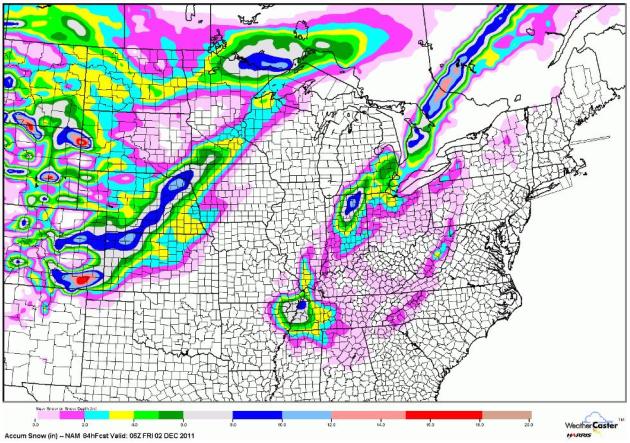
Snow In Unlikely Places. The latest NAM model predicts 4-8" snow near Memphis - Indianapolis could pick up a half foot of slushy snow, with 8" for South Bend, even a few inches for the suburbs of Detroit. Map courtesy of WeatherCaster.
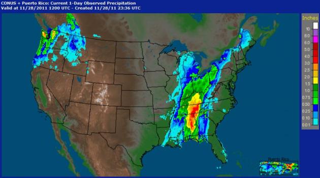
 Winter Storm Warnings....For Alabama?
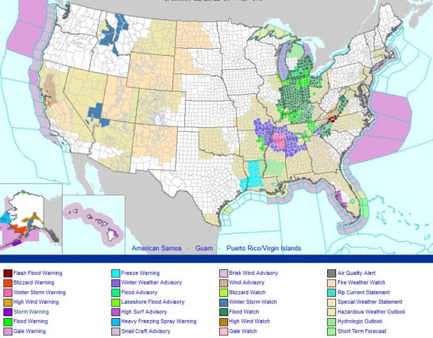
 Yes, while we see bright sun and temperatures a few degrees above average, folks down south will be shoveling, and plowing, and probably shaking their fists at Old Man Winter. Flood watches are posted from Lower Michigan southward to Kentucky for some 1-3" rainfall amounts. For the latest (interactive) watches and warnings from NOAA click
here.
Rainfall Amounts, courtesy of NOAA HPC:
..ALABAMA...
MENTONE 3.9 SW                        5.22
SYLVANIA 3.4 ESE                      4.81
ROSA 2.8 SW                           4.07
PRINCETON 3.6 NW                      3.93
BIRMINGHAM MUNI ARPT                  2.95
ANNISTON METRO AIRPORT                2.84
MONTGOMERY/DANNELLY                   2.84
ALABASTER/SHELBY CO. ARPT             2.71
MAXWELL AFB/MONTGOMERY                2.70
ALEXANDER CITY                        2.51
HUNTSVILLE/MADISON CO. ARPT           2.22
MOBILE DOWNTOWN AIRPORT               1.74

...FLORIDA...
TYNDALL AFB/PANAMA CITY               2.67
VALPARAISO/EGLIN AFB                  1.80

...GEORGIA...
LA FAYETTE 2.9 NE                     4.00
TRENTON 5.8 S                         3.95
DILLARD 3.5 NE                        3.74
LYERLY 4.8 SSE                        3.62
SUMMERVILLE 2.6 NW                    3.51
RABUN GAP 2.1 SW                      2.94
ROME 3.4 SE                           2.70
CARTERSVILLE AIRPORT                  1.26

...KENTUCKY...
ALBANY 5.3 W                          3.10
WINDSOR 1.2 NW                        2.55
LEXINGTON/BLUE GRASS FIELD            2.23
LIBERTY 1.1 SE                        2.13
LONDON-CORBIN ARPT                    2.10
FRANKFORT/CAPITAL CITY ARPT           1.93
BOWLING GREEN-WARREN CO. ARPT         1.57
FORT KNOX AAF                         1.34
OWENSBORO/DAVIESS CO. APT             1.22

 ...NORTH CAROLINA...
FRANKLIN 7.5 SW                       3.64
ROSMAN 5.3 W                          3.56
ASHEVILLE MUNI ARPT                   1.18

 ...OHIO...
CINCINNATI (ASOS)                     1.54
HAMILTON ARPT                         1.43
DAYTON GENERAL AIRPORT                1.19

...TENNESSEE...
WHITWELL 4.5 ENE                      5.07
DUNLAP 0.4 SSE                        4.83
CHATTANOOGA-LOVELL FIELD (ASOS)       4.64
RED BANK 3.4 NNE                      4.59
JASPER 1.7 N                          4.40
OAK RIDGE (ASOS)                      3.72
CROSSVILLE MEMORIAL ARPT              3.64
SMYRNA AIRPORT                        1.66
NASHVILLE METRO ARPT                  1.54
KNOXVILLE MUNI ARPT                   1.53
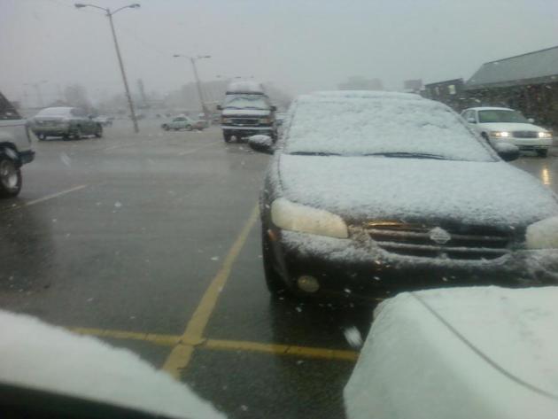 Jackson, Tennessee
. Thanks to @randomgrl on Twitter for passing this along.
Monday Rainfall. NOAA
Doppler radar estimates showed some 3-5" rainfall amounts over Alabama and Tennessee yesterday.
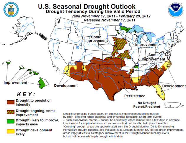
Improving Drought Conditions For Minnesota? NOAA's
Drought Monitor is predicting an easing of drought conditions for southern Minnesota in the months to come, but personally, I'm not convinced. This forecast is based on an active La Nina pattern and a forecast calling for wetter than average conditions for the northern tier states. While New England and parts of the Great Lakes will almost certainly experience a snowier/wetter than average winter, I'm still concerned that prevailing jet stream winds will whisk the wettest storms south/east of Minnesota for much of the winter season. We'll see, but I still believe the drought may get worse before improving sometime in 2012. Hope I'm wrong.
Active 2011 Hurricane Season Breaks "Hurricane Amnesia". Here's a recap of a very busy hurricane year from
NOAA: "
The 2011 Atlantic hurricane season officially ends Wednesday, having produced a total of 19 tropical storms of which seven became hurricanes, including three major hurricanes. This level of activity matched NOAA’s predictions and continues the trend of active hurricane seasons that began in 1995. The 19 tropical storms represent the third-highest total (tied with 1887, 1995, and 2010) since records began in 1851 and is well above the average of 11. However, the number of hurricanes and major hurricanes is only slightly above the average of six and two, respectively. This year’s totals include a post-storm upgrade of Tropical Storm Nate to hurricane status, and the addition of a short-lived, unnamed tropical storm that formed in early September between Bermuda and Nova Scotia. This unnamed storm, along with several other weak, short-lived named storms, could have gone undetected without modern satellite technology. Irene was the lone hurricane to hit the United States in 2011, and the first one to do so since Ike struck southeast Texas in 2008. Irene was also the most significant tropical cyclone to strike the Northeast since Hurricane Bob in 1991. “Irene broke the ‘hurricane amnesia’ that can develop when so much time lapses between landfalling storms,” said Jack Hayes, Ph.D., director of NOAA’s National Weather Service. “This season is a reminder that storms can hit any part of our coast and that all regions need to be prepared each and every season.”
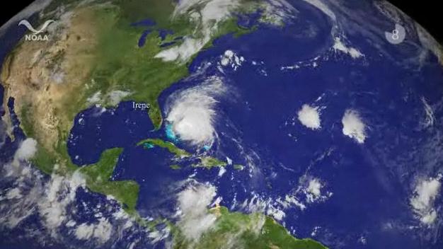
The 2011 Atlantic Hurricane Season In 4.5 Minutes. The world's longest satellite loop? The press release from
NOAA: "
The 2011 Atlantic hurricane season officially ends on Nov. 30 and produced a total of 19 tropical storms of which seven became hurricanes, including three major hurricanes. This level of activity matched NOAA’s predictions and continues the trend of active hurricane seasons that began in 1995. From Arlene to Sean, Hurricane Season 2011 has been very active, leading to 120 fatalities and causing more than $11 billion in property and infrastructure damage. Surprisingly, none of the first eight tropical storms reached hurricane status, a record since reliable reports started in 1851. Hurricane Irene's effects in the Caribbean and the United States lead to 55 deaths and accounted for the bulk of this season's damage, more than $10 billion. Irene was the first landfalling hurricane in New Jersey in 108 years. Hurricane Katia had far-reaching effects causing severe weather in Northern Ireland and Scotland and power blackouts as far east as Saint Petersburg in Russia. Tropical Storm Lee caused major flooding in Pennsylvania, New York and into the Canadian provinces of Quebec and Ontario. The strongest storm of the season was Ophelia, which reached category four strength in the Atlantic Ocean east of Bermuda."
2011 Hurricane Season Was Windy And Wild, But Not In South Florida. The
Palm Beach Post has the story: "In the hurricane season that ends Wednesday, storms mostly have been a non issue for South Florida. The season brought a couple of scares, including Irene - which threatened a direct hit on New York City and then made a rare assault on the Northeast, causing as much as $3 billion in damage. But for the sixth straight year, no hurricane made landfall in Florida. Not even a tropical storm in 2011. So, if asked whether this was a busy year, most would again say no. They'd be wrong. It was a doozy.
The 2011 season generated 19 tropical storms, of which seven became hurricanes and three became major hurricanes, at Category 3 or higher on the Saffir-Simpson scale. That ties with 2010, 1995 and 1887 for third-busiest on record. (image above courtesy of NHC and NOAA).
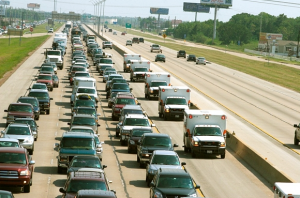
Weather Disaster + Business Travel: Dangerous, Disruptive and Costly. From the
Sacramento Bee:
"On the heels of Hurricane Irene and a freakishly early fall snowstorm, and with the impending onslaught of severe winter storms, the Global Business Travel Association has quantified the impact of major weather events on business travel. The research uses GBTA's Business Travel quarterly (BTQ) methodology to determine how a theoretical Category-3 hurricane on the East Coast would impact the business travel industry. The results can be applied to any significant weather event that leads to widespread shutdowns and canceled travel plans, such as East Coast snowstorms."
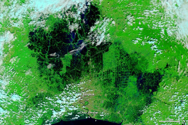
Bangkok: Visiting The Flooded City. The scope of flooding in Thailand is overwhelming;
Huffington Post has an eye-opening overview of the mess its left behind: "
In the weeks leading up to my Southeast Asia trip, I became a flood junkie, reading anything I could get my hands onto regarding the situation in and around the Thai capital. Some reports compared Bangkok to post-Katrina New Orleans, others stated that once monsoon season ended, the city would take exactly 10 days to completely drain. Insiders and locals I spoke to said that the most important part I could play as a traveler was to go on my trip and support the local economy. I didn't change my plans and returned to Bangkok, a city of fascinating juxtapositions and one of Asia's most vibrant capitals. And I can report that its current state is a composite of everything I had read: The flooding is everywhere and nowhere. The biggest difference I noticed on my first morning, waking up in a river-view room at the Mandarin Oriental: The Chao Phraya River was silent. Instead of the incessant, traffic jams of small-to-supersized boats making their way up and down and across this Thai lifeline, there were just a couple of hotel shuttles drifting quickly, and often sideways, down the gushing water. Other than the changed river-picture, however, everyday life continues in central Bangkok as always: buzzing, relentless. Many of the sights and temples, like the Grand Palace, Wat Po and Wat Arun are lined by sandbags, but all is dry and open for business." Image above courtesy of NASA's Earth Observatory.

Climate Stories...
Another Try For A Global Climate Effort. Cue the theme from Mission Impossible. Sadly, my expectations for climate talks in Durban are very modest. The world is looking to the USA for leadership on this issue. They're not finding it. The latest from the
New York Times: "
WASHINGTON — With intensifying climate disasters and global economic turmoil as the backdrop, delegates from 194 nations gather in Durban, South Africa, this week to try to advance, if only incrementally, the world’s response to dangerous climate change. To those who have followed the negotiations of the U.N. Framework Convention on Climate Change over their nearly 20-year history, the conflicts and controversies to be taken up in Durban are monotonously familiar — the differing obligations of industrialized and developing nations, the question of who will pay to help poor nations adapt, the urgency of protecting tropical forests, the need to develop and deploy clean energy technology rapidly."
Tom Brokaw: Climate Change Is Real. From
Huffington Post: "Days before the
Global Climate Talks in Durban, South Africa, NBC's Special Correspondent
Tom Brokaw delivered a strong message in
Silicon Valley for
climate skeptics. In response to a
Fresh Dialogues question about climate change, Brokaw said, "It's real, we see it in our weather systems," and made a somber call to action, saying everyone needs to take a part. Brokaw, who has hosted
two documentaries about global warming for the
Discovery Channel, says he's planning an expedition to Antarctica with a team of climate scientists to record the glacial melting next January."
 Global Warming? Yes, But Hold The Extremes
. A story from the
Orange County Register: "
Rising global temperatures in the decades ahead might be unlikely to reach the most extreme forecasts seen in previous estimates, including those of the Intergovernmental Panel on Climate Change, a new study of ice-age climate data shows. "Some of those very high climate sensitivities can be excluded," said lead author Andreas Schmittner of Oregon State University. "But it really doesn't change the fact that we have global warming, that it's man-made and that it can potentially lead to very severe consequences in the future."
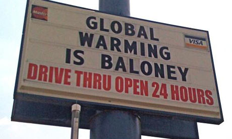 Climate Change Denial Still Runs Strong In U.S
.
AFP has the story: "
WASHINGTON — On the US political stage, skepticism and denial of climate change are as popular as ever, and experts say that world talks which opened Monday in Durban, South Africa are unlikely to turn the tide. But while a binding deal on harmful carbon output remains elusive by the world's second biggest polluter after China, some small signs of progress have emerged at the state and individual levels. Last month, the most populous US state, California, approved rules for a carbon market that would start in 2013, with the goal of cutting emissions to 1990 levels by 2020. Previous attempts to create a cap and trade system to stem pollution at the federal level have failed due to concerns it would cause skyrocketing energy costs, a particularly bruising prospect in an already wobbly economy."
