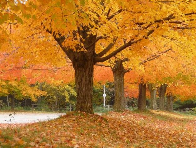
Wednesday was the 65th anniversary of the start of the biggest November snowstorm in Denver`s history, a storm which produced
30.4 inches in three days. - Earth Networks.
5.9" new snow fell on Denver Wednesday. Portions of I-25 and I-80 were closed due to drifting snow and whiteout conditions.
.6" snow reported in Omaha, Nebraska Wednesday.
58.43" precipitation in Cincinnati so far in 2011. The old record was 57.58" in 1990.
Mixed Up Weather Map. New York City and Philadelphia received measurable snow before Anchorage, AK. ANC got 1″ on Oct 30, NYC and Philly got theirs on Oct 29. Amazing but true.
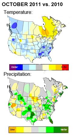
South Florida: October, 2010 was driest on record. October, 2011 was the 4th wettest on record.
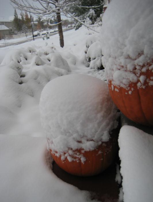
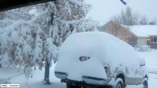
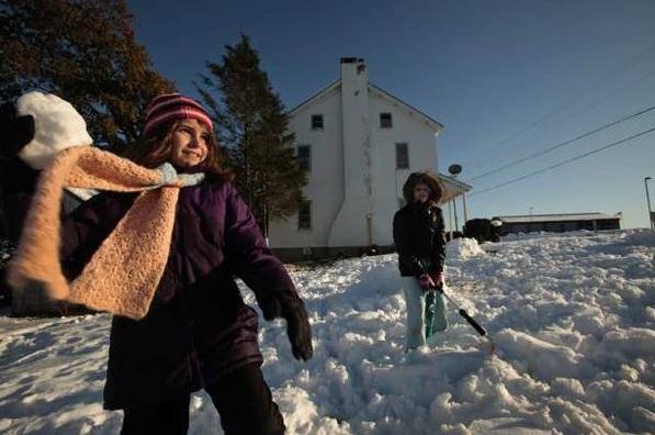
Denver: An Early Winter. Thanks To Matt Herrmann from Louisville, Colorado for sending in this photo of a very snowy Denver. Portions of I-25 and I-80 were shut down for a time early Wednesday, due to drifting and near white-out conditions.
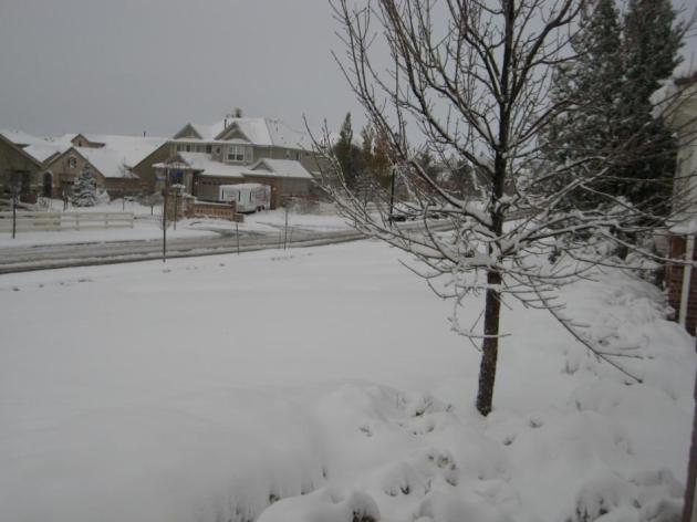
Swamped With Snow. That looks like a good 8" of snow out at Aurora, a suburb of Denver. Thanks to Angelina Rodriguez for posting this on the "WeatherNation"
Facebook page.
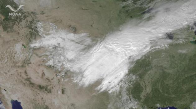
Heavy Snow Blankets The Rockies. A release from
NOAA: "
The storm system that blanketed Colorado and Wyoming is heading east into the central U.S. today, November 2, 2011. As it does, a wave of low pressure at the surface will develop near the Oklahoma Panhandle and move northeastward. As the low pulls toward the east, heavy snow will come to an end for the Colorado Rockies. Snow will still be possible on the back side of the low pressure system through tonight for areas from the Oklahoma Panhandle into southwest Iowa. As moisture from the Gulf of Mexico feeds into the system a large area of rain is expected to develop across parts of the central U.S. This image was taken by GOES East at 1815Z on November 2, 2011."
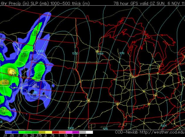
 Predicted Snowfall.
 Here is the GFS solution through 1 pm Monday, showing additional snow from Colorado and Wyoming into North Dakota.
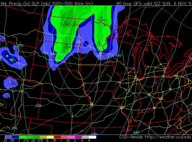
 Saturday: Windy and Mild
. At 7 pm Saturday the NAM model shows an intense area of low pressure northeast of Denver, south/southeast winds howling across the Great Plains, snow limited to the Northern Rockies and western Dakotas. Highs may reach the mid to upper 50s Saturday as far north as the Twin Cities and Milwaukee.
 Deer Hunting Firearm Opener.
 It will look and feel more like late September or early October out there on Saturday, sun fading behind increasing clouds, a stiff southeast wind (15-30 mph) with highs well up into the 50s. 60-degree highs aren't out of the question south of the Minnesota River.
 Sunday Morning: Brushed By Showers
. We stay on the mild side of the storm track through the first half of the day Sunday, highs reaching the 50s (to near 60 south/east of the Twin Cities). Rain showers are most likely north of the metro area Saturday night and Sunday.
Dry October in Minnesota. Here are some details from the Minnesota State Climatology Office:
- October 2011 was another very dry month throughout Minnesota. This marked the third consecutive month of widespread rainfall shortfalls. In some locales, it was among the driest Octobers of the modern record.
- Significant rainfall shortfalls were reported across Minnesota over the past three and one-half months. When compared with the same fourteen-week period in the historical database, late-summer plus autumn 2011 precipitation totals rank among the lowest on record for numerous southern Minnesota locations.
- The U. S. Drought Monitor depicts nearly every Minnesota county as experiencing some level of drought. Large sections of northeast and north central Minnesota are said to be undergoing Severe Drought or Moderate Drought. The Drought Monitor also places a large portion of southern Minnesota in the Severe Drought or Moderate Drought categories.
October Weather Factoids. Here's some interesting information about October, courtesy of
Planalytics:
"
From a weather perspective, October had a bit of everything. In North America, temperatures were above normal, although cooler than last year, helping year-over-year seasonal demand. Precipitation was also above normal and last year. The U.S. had its 12th warmest October in 51 years, although still cooler than last year. Precipitation trended near normal. Canada had its warmest October since 2007 and wettest since 2006. Snowfall was notable, particularly in the U.S., highlighted by a late-month storm in the Northeast. Snowfall across the US was 209% greater than last year and 26% above normal. Snowfall in Canada was 166% greater than last year and above normal.
Significant Weather Events:
- October began in the U.S. with the warmest first week since 2007 and was wetter than last year, although drier than normal. In Canada, the first week was the warmest since 2005 with above normal rain.
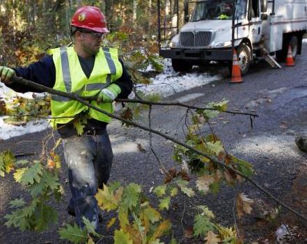
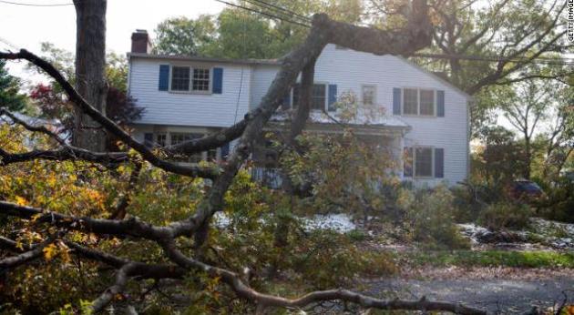
Feds: Response To Snowstorm Slower Than To Irene. There are a lot of very unhappy people living in the northeast, many still without power, 5 days after a freak October snow blitz.
USA Today reports on the response: "
HARTFORD, Conn. (AP) – Utility crews have been slower to fix Northeast power outages caused by last weekend's record-setting snowstorm than they were after Hurricane Irene and its remnants because they had less time to prepare, a U.S. Department of Energy official said Tuesday. Bill Bryan, a deputy assistant secretary for the agency, said during a stop in hard-hit Connecticut that he was monitoring the mutual aid response that has sent thousands of extra workers into the region. The freak October snowstorm knocked out power to 3 million homes and businesses from Maryland to Maine. About 1.6 million customers remained without power Tuesday. Bryan says utility companies didn't have time to get additional workers from other regions in place before the snowstorm like they were able to do before Irene in August. The companies had several days to prepare for Irene and only a few days to prepare for the snowstorm, which hit the region harder than was forecast. At midweek last week, some forecasters said the storm was going to miss New England."
States Scramble To Restore Power After Snowstorm. Ironically, Saturday's premature snowy plastering has had a much bigger impact on much of the northeast than Hurricane Irene did back in August, or Tropical Storm Lee in September.
CNN reports: "
New York (CNN) -- Utility companies in five states scrambled to restore power to more three quarters of million people still in the dark by late Wednesday afternoon after a snowstorm pounded the U.S. Northeast over the weekend. A massive snowfall that started Saturday downed trees and power lines, knocking out electricity to customers in various states, including Connecticut, New York and New Jersey. New Jersey resident Becky Fisher said she moved her family to a neighbor's home after they lost power and temperatures dropped to near freezing. Fisher, along with her husband and their 6-month-old daughter, have camped out at the neighbor's house in Maplewood, New Jersey, since the weekend storm coated her home in snow and knocked down trees and power lines."
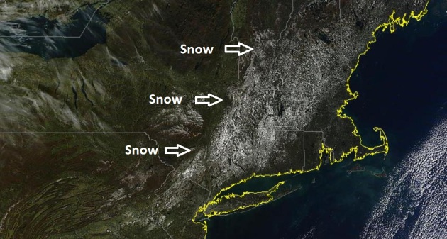
Lingering Snowcover. It's been 5 days since 1-2 feet of heavy, wet snow plastered much of the northeast, and there's plenty of snow left on the ground.
Here is the latest NASA "Modis" image taken from the low-orbiting "Terra" weather satellite, a little more than 200 miles above the ground.
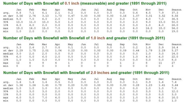
Snowy Probabilities. The Minnesota State Climate Office just released some updated numbers for MSP. On average the Twin Cities sees 4.5 days every November with a tenth of an inch or more of snow and 1.8 days with 1"+ snow. Click
here to see the details. Here's more information (glad to see they're using the term, "plowable" snow!) "
Assuming that it is agreed that a two-inch snowfall is "plowable", the Days with Snowfall ... 2.0 inches and greater table below indicates that on average, a "plowable" snowfall occurs in the Twin Cities 7.4 days per season, with a standard deviation (a measure of variability) of 3.43 days. In tandem, these statistics inform users that during most seasons (two-thirds of all seasons), the metropolitan area receives two or more inches of snow between four and eleven times. The table also indicates that decision makers should account for the fact that the Twin Cities has had seasons with as many as 16 days of "plowable" snow, and as few as one day of "plowable" snow."
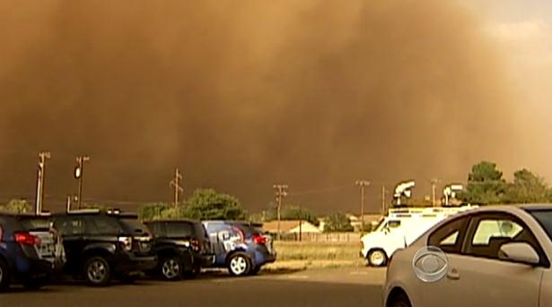
Storms Slamming Southwest Evoke Dust Bowl. According to NOAA the USA just experienced the hottest summer since 1936, at the height of the Dust Bowl.
CBS News has a story on the apparent uptick in extreme weather worldwide: "
Top scientists are warning that recent extreme weather patterns could continue well into the future. A draft report obtained Tuesday by The Associated Press says climate change will mean more floods, more heat waves and more droughts. And in bone-dry Texas, that future is now, as CBS News correspondent Anna Werner reports on the dust storms that are swirling in the Lone Star State. Lubbock, Texas hadn't seen anything like it in decades. The dust storm on October 17 stretched more than a mile high, with wind gusts of 75 mph -- hurricane-force. Kevin Watt recorded it on his iPhone. "It came in like a cloud," he said, "but you realize, 'Hey that's dirt.'"
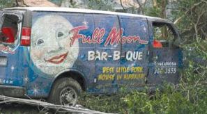
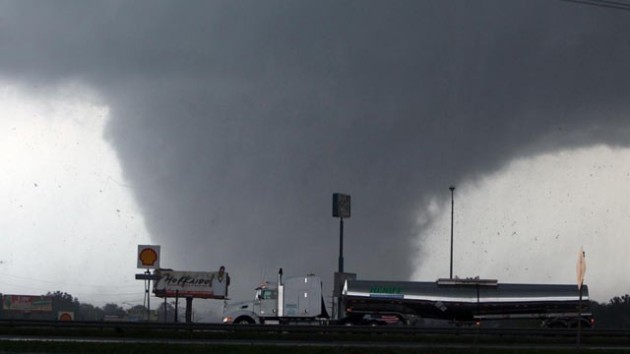
Tornado-Affected Businesses Face Uncertain Future. Alabama's
Crimson White has the story: "
When an EF4 tornado tore through Tuscaloosa last April, it left businesses, homes and lives destroyed in its wake. Now, six months later, much of the debris has been cleared, but the damage has yet to be repaired. In place of Southern institutions like Hobby Lobby, Full Moon BBQ and Krispy Kreme, there remain bare foundations and scoured patches of earth. Some businesses have gathered the pieces and started rebuilding, while the status of others remains less clear. New construction is somewhat scarce in tornado-affected areas of Tuscaloosa, and affected businesses seem unsure of their future. CVS, which had its building damaged in the tornado, is one business that is slowly recovering. After moving employees to one of six other CVS locations in the Tuscaloosa area, the pharmacy began using a CVS-owned RV, which was last used during Hurricane Katrina, to serve as a temporary location."
FEMA: Be Prepared For Future Disasters. Here's a press release from
FEMA with a few useful reminders: "
Be prepared for future disasters. Stay informed about weather conditions…including the potential for flooding…and know the risks involved. Purchase and program a National Oceanic and Atmospheric Administration (NOAA) weather radio to receive watches and warnings issued by the National Weather Service. NOAA weather radios range in price from $30 to more than $100, depending on features, and can be purchased at any retail store that sells electronics. Determine the risk and take the necessary precautions. Never drive through water. Take action to reduce potential water damage. Consider flood insurance as well as property insurance against strong winds. Review your insurance coverage with your insurance agent, and update your coverage amounts as necessary. Consider elevating utilities or appliances – even the entire home. Focus on protecting and reinforcing the roof, windows and garage against strong winds. Keeping these in place could lessen overall damage during straight-line winds or a tornado. Install “hurricane straps” – very effective during tornado activity - and shutters. Consult a building contractor, home improvement store or go to the following websites: www.fema.gov and www.ready.gov. "
6 Months Later: The April, 2011 Tornado and Severe Storm Outbreak. A few highlights from
FEMA on what's happened in the last 6 months, since 750 tornadoes touched down in April, the most ever observed in one month in the United States:
- NOAA’s National Weather Service ranks April 2011 as the most active tornado month on record with 750 tornadoes across the U.S. There were a reported 361 fatalities.
- The April 27 “Super Outbreak” spawned four intensely destructive EF-5 and 11 EF-4 tornados across Alabama, Georgia, Kentucky, Mississippi and Tennessee.
- These storms launched an immediate response from the whole community, which included local, state, and federal agencies, voluntary, faith-based and community groups, the private sector and the public.
- Nearly $257 million in federal disaster assistance was distributed to survivors in the form of grants and low-interest recovery loans, as of October 20.
- FEMA obligated nearly $211 million in federal aid to local and state government and non-profit agencies to reimburse costs for public recovery and rebuilding projects such as debris removal and repairs to public facilities.
- FEMA provided more than $254 million in direct Federal assistance through mission assignments to other federal agencies for other essential commodities, emergency work and debris removal.
* tornado photo courtesy of ABC News.
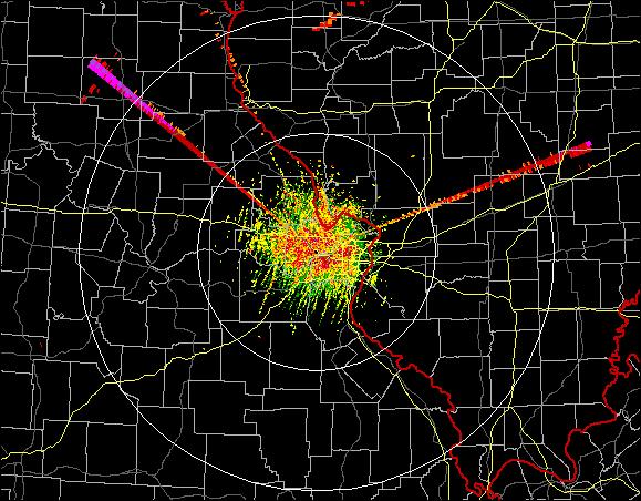
4G Interfering With NWS Doppler? Check out this post from
Madweather, focusing on strange radar "spikes" visible in recent days on St. Louis Doppler radar:
"
The above is base-scan reflectivity from the NWS radar at LSX (St. Charles/St. Louis, Missouri) - time about 1800 UTC today (Wednesday, November 2nd). I have been noticing these strange, and persistent, clear air returns for a number of days, and asked about them in an e-mail. The LSX Webmaster replied: It is interference on our radar being caused by radio interference from 4G wireless internet towers that are popping up across the metro area. The Radar Operations Center in Norman Oklahoma is working on a filter that will dampen out these spikes. Hopefully they will be able to implement the filter later this year."
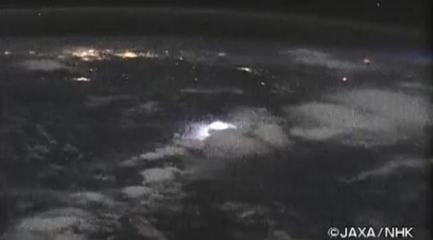
T-storms From Space. Check out this remarkable
YouTube clip, courtesy of NHK. Astronauts onboard the ISS, the International Space Station, aimed a video camera out a window - things get interesting about 2:20 into the video.
The Best Gadgets - Um - "Productivity Tools". Here is
Gizmodo's list. Techno-geek that I am, I'll have my own list a little closer to Christmas: "
What gadget should I get?" is a timeless question. To answer it, here's our current leaderboard of favorite gadgets, including smartphones, laptops and cameras—updated with the latest and greatest. We know you don't want to blow that paycheck on merely the shiniest, or the the simply newest. So we've considered a balance of price, features, reliability—and above all, quality—to make sure you're choosing a gadget that isn't just great, but one that's sensible. We've updated our roster of Giz-approved gadgets, and below, you'll find these picks."
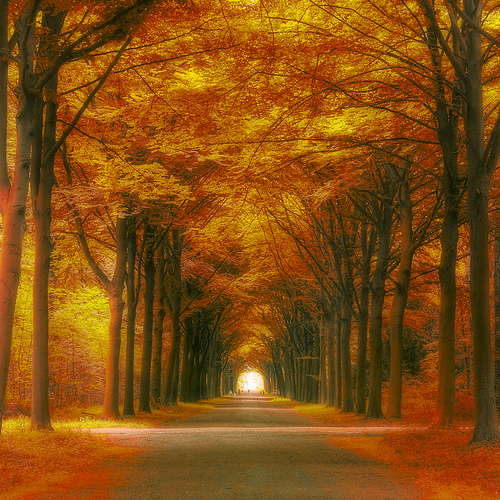
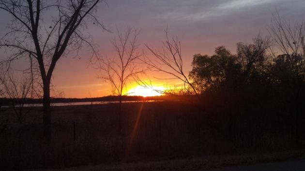 Sunny Finale
. WeatherNation meteorologist Katie Ferrier snapped this picture of a setting sun Wednesday, a tip-off of a bright, sunny Thursday to come.
Interesting Times
"May you live in interesting times." The last 2 years have been off-the-scale crazy for weather folk. 2010 ties for the hottest year ever, a slow-motion 7-month flood on the Missouri River - Alabama is now America's tornado capital, 2011: hottest summer since the Dust Bowl of '36, record rains from New England to Florida while Texas burns, massive "haboobs" (dust storms) observed from Phoenix to Lubbock. And now the freakish "Snow-tober" storm, unlike anything we've seen since 1800 - possibly the most snow ever so early in the season over the northeast.
Another head-shaking weather factoid: it snowed 1" in New York and Philadelphia before it did in Anchorage, Alaska! Welcome to the Twilight Zone of Meteorology.
Climate Stories...
"Snowtober" Fits U.N. Climate Change Predictions. Here's a timely analysis of not only last Saturday's historic snow event, but 2 years of increasingly crazy weather worldwide, courtesy of the
L.A. Times: "
While the Northeast is still reeling from a surprise October snowstorm that has left more than a million people without power for days, the United Nations is about to release its latest document on adaptation to climate change. The report from the Intergovernmental Panel on Climate Change is expected conclude that there is a high probability that man-made greenhouse gases already are causing extreme weather that has cost governments, insurers, businesses and individuals billions of dollars. And it is certain to predict that costs due to extreme weather will rise and some areas of the world will become more perilous places to live. Federal climate scientists have labeled 2011 as one of the worst in American history for extreme weather, with punishing blizzards, epic flooding, devastating drought and a heat wave that has broiled a huge swath of the country. Weather related losses amounted to more than $35 billion even before the Nor'easter shellacked the East Coast."
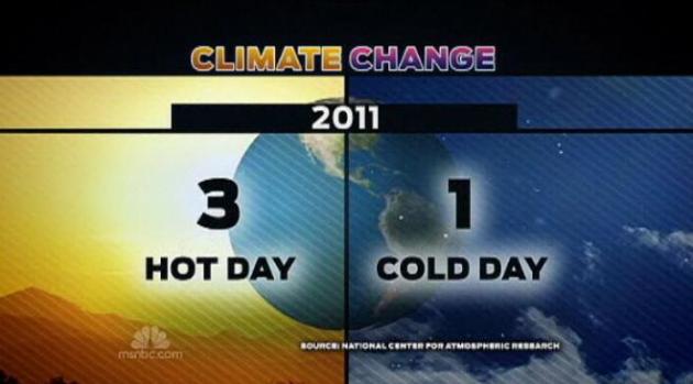
More Weather Disasters Ahead, Climate Experts Report. So far in 2011 record highs have outnumbered record lows by a 3 to 1 margin.
NBC News has a good overview on how a warmer (wetter) atmosphere may be a breeding ground for more numerous and extreme weather disasters: "
The report from the Nobel Prize-winning Intergovernmental Panel on Climate Change will be issued in a few weeks, after a meeting in Uganda. It says there is at least a 2-in-3 probability that climate extremes have already worsened because of man-made greenhouse gases. This marks a change in climate science from focusing on subtle changes in daily average temperatures to concentrating on the harder-to-analyze freak events that grab headlines, cause economic damage and kill people. The most recent bizarre weather extreme, the pre-Halloween snowstorm, is typical of the damage climate scientists warn will occur — but it's not typical of the events they tie to global warming." (video from NBC News, story from AP).
Thailand's Heart Attack. Climate change doesn't trigger specific extreme weather events - but it may raise the odds of record events, according to the
L.A. Times: "
An obese, middle-aged man is running to catch a bus. Suddenly, he clutches his chest, falls to the ground and dies of a massive heart attack. It turns out that he's a smoker and a diabetic, has high blood pressure, eats a diet high in saturated fat and low in leafy green vegetables, pours salt on everything, drinks too much beer, avoids exercise at all costs and has a father, grandfather and two uncles who also died young of heart attacks. So what killed him? Most people are savvy enough about health risks to know this is a trick question. You can't pick out a single cause. His choices and his genes all contributed to the heart attack — but you can say with confidence that the more risk factors that pile up, the more likely it is to end badly. Somehow, though, people think that it makes sense to ask whether a given extreme weather event — a devastating heat wave or a punishing drought or a deadly torrential rainstorm — is caused by climate change."
Climate Change Bulks Up Birds.
Discovery News has the unlikely story: "
Big birds are gaining more than attention on Sesame Street. Birds in central California have been growing larger for several decades. Researchers think climate change may be bulking up the birds, while other studies suggest some animals and plants are shrinking in a warming world. Researchers from San Francisco State University and other institutions noticed the feathered-friend trend while analyzing data from thousands of birds caught and released over the years at two sites near San Francisco Bay and the Point Reyes National Seashore. The birds increased in mass and their wings grew longer over the past 27 to 40 years. "The fingerprint of climate change is showing up in many of our ecosystems," said Nat Seavy, of Point Reyes Bird Observatory Conservation Science, another organization involved in the research, in a press release."