70 F. record high in Washington D.C. on Sunday. Normal high for November 27 is 53.
"
Despite the usual exhortations by those forecasters pushing the numerous predictive "indices", we are not headed for another ice age in the U.S. next month. NO numerical model shows a high-latitude blocking signal, so any cold that does make its way through the lower 48 states will likely be of the "quick hit" variety." - meteorologist Larry Cosgrove.
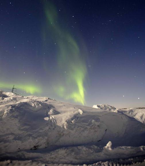
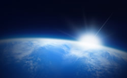
An elevated chance of seeing the Northern Lights this week? Details below. Photo courtesy of NASA.
"A Class 3 warning means that a storm is so powerful that it can be dangerous to be outside." - from a Swedish web site warning of yet another severe winter storm.
Elevated Chance Of Seeing The Aurora Borealis? A recent CME (coronal mass ejection) on the surface of the sun has created a surge of charged particles, the "solar wind", which may react with Earth's magnetic field to produce some potentially spectacular examples of the Northern Lights in the nights ahead.
Spaceweather.com has more details: "
A solar radiation storm is in progress around Earth. At the moment, the storm is classified as minor, which means it has little effect on our planet other than to disturb HF radio transmissions at high latitudes. Bigger effects, however, may be in the offing. The same explosion on Nov. 26th that caused the radiation storm also hurled a CME into space at about 930 km/s (2 million mph)."
* Check out NASA's space weather page
here.
Tuesday Storm For East Coast. A negatively tilted trough, a whirlpool of unusually cold air aloft, will spin up an intense storm for the east coast, complete with heavy rain, embedded thunderstorms, strong winds and possible beach erosion. Temperatures aloft should be warm enough for mostly-rain. Map courtesty of NOAA NCEP.
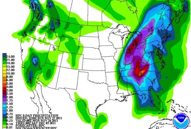 East Coast Soaker
. Yes, that's a 5.8" bullseye north of Atlanta. Five day rainfall amounts will top 1-3", with the heaviest amounts from the Appalachians westward to Detroit, Indianapolis and Louisville.
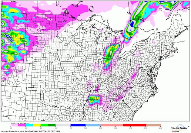 Predicted Snowfall Through Midnight Wednesday Night
. Enough cold air may filter into the east coast storm for a few inches of accumulation from near Flint and Ann Arbor, Michigan southward to South Bend, even Indianapolis. NAM data courtesy of NOAA NCEP and WeatherCaster.
No Sign Of (Persistent) Bitter Air. Meteorologist Larry Cosgrove, who specializes in long-range forecasting from his Houston office, had this vaguely reassuring analysis in his
WEATHERAmerica newsletter: "Despite the usual exhortations by those forecasters pushing the numerous predictive "indices", we are not headed for another ice age in the U.S. next month. NO numerical model shows a high-latitude blocking signal, so any cold that does make its way through the lower 48 states will likely be of the "quick hit" variety. I suspect that the colder air will dominate in the first portion of the extended period, then abate as the upper flow takes on a more semizonal bent."
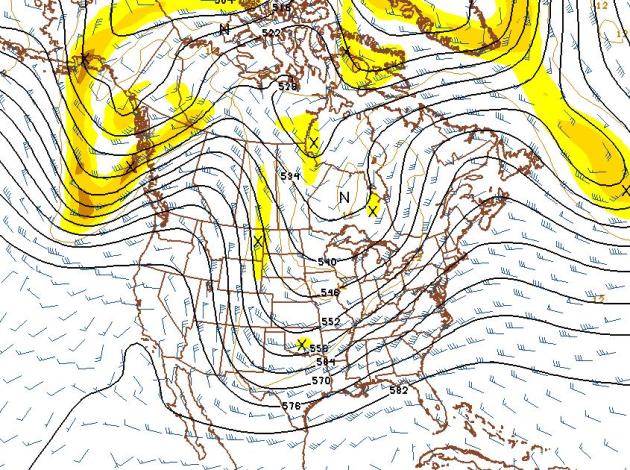
* GFS 500 mb forecast map above is valid December 13. It shows a trough of low pressure over the nation's midsection capable of spinning up a storm for the Mississippi River Valley and Great Lakes. There's still no evidence of a full-latitude blocking pattern capable of funneling consistently bitter air south from the Arctic Circle or Alaska. The coldest, Siberian air is being shunted well north - no evidence of any subzero air making a pass at the lower 48 through mid December.
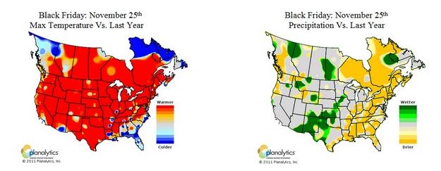
An Almost Octoberlike Thanksgiving Holiday Weekend For Much of America.
Planalytics.com has the details: "
Mother Nature also gave her support to businesses over the holiday weekend. Over 95% of the population experienced temperatures that were warmer than last year. Nationally, temperatures were +9.8F warmer than last year. The Black Friday weekend trended the warmest in 5 years with the least amount of snowfall since 1999. Black Friday itself had the least amount of rain in 5 years. Late weekend rainfall in interior locations from the Gulf Coast to the Great Lakes provided challenging travel conditions for those headed home."
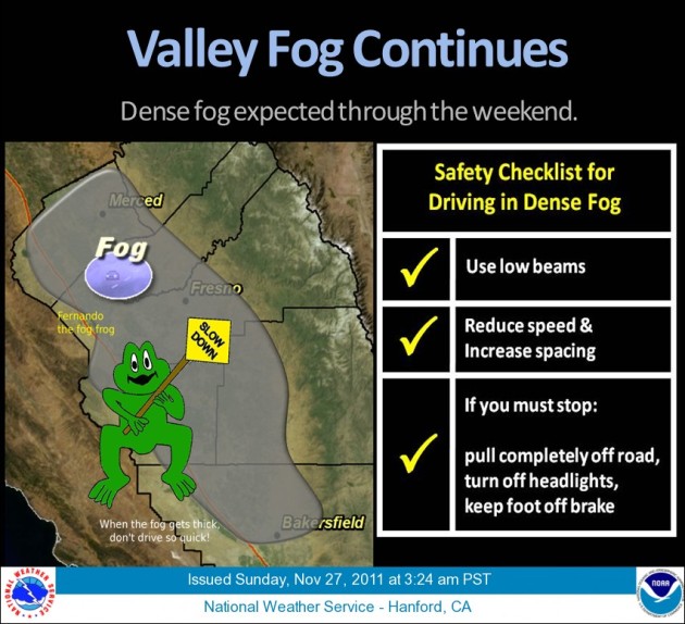 Fernando The Frog Says Slow Down!
 Always good advice, but especially so for motorists in California's Central Valley. Long nights and lingering moisture have combined to produce thick, zero-visibility "tule fog", so dense it often doesn't dissipate by afternoon.
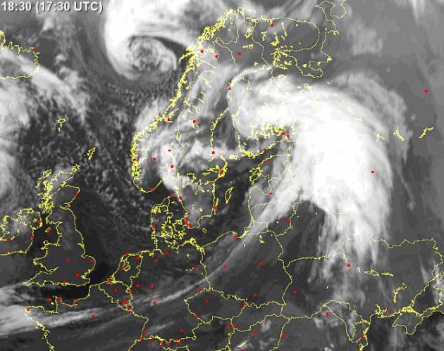
Class 3 Warning As Severe Storms Lash Sweden.
"The Local" has more information on a series of very powerful storms taking aim at Sweden:
"With parts of southern Sweden still reeling from the damage caused by the storm dubbed Berit, residents have been warned that even worse weather is on its way and have been warned not to go out unless it is absolutely necessary.
With gales causing havoc in many parts of the country on Saturday, Sweden’s Meteorological and Hydrological Institute, SMHI, issued a Class 2 warning across counties Skåne, Halland, Gothenburg and Bohuslän, during the morning. By the afternoon, however, the institute upped the warning to class 3 for Skåne and Halland, predicting gale force winds of up to 30 metres per second for the two southern counties. Western Sweden will fare little better, with a predicted wind speed of 25 metres per second. “It could be as strong as Gudrun,” SMHI meteorlogist Ibrahim Almausawe told Aftonbladet, referring to a storm from 2005 still very much alive in Sweden's memory due to the damage it caused."
* satellite photo above courtesy of sat24.com.
Using Cutting-Edge Technology, UW Leads The Way In Weather Forecasting. Let's give credit where credit is due: the University of Wisconsin has one of the more prolific and prestigious meteorology programs in the USA. St. Cloud State University is the only school in Minnesota offering a 4 year meteorology degree, and they have a terrific program, in fact many of our meteorologists, on air and off the air, hail from St. Cloud. I could never understand why the U. of Minnesota didn't invest in a meteorology program - I could never really get a good answer. For students interested in meteorology the U. really isn't much of an alternative; I encourage them to check out St. Cloud State University, The U. of Wisconsin, and also the U. of North Dakota at Grand Forks and Iowa State, home of the "Cyclones".
Madison.com has the details on Wisconsin's program at Madison: "
This wizardry is made possible almost entirely by what experts agree is the greatest innovation in weather forecasting since the woolly worm — high-tech satellites. Both orbiting and stationary satellites now allow researchers to see otherwise invisible atmospheric signs that tell of the formation and movement of the weather systems that so affect our lives. The advent of satellite weather forecasting had its beginnings here in the late 1950s with science that led to the launching of the first instrument-laden satellite. Such innovation continues, as was evidenced by the announcement that a new satellite loaded with UW-Madison technology was sent into space in late October as well as news of a super computer taking shape in the building that will allow for even better forecasting and weather science."
For The Weather Fanatic Who Wants It All. It's official, Nike has a new line of tennis shoes/sneakers, the Nike Zoom KD IV "Weatherman" series.
Preview of Winter?
"As November goes, so goes the winter". Really? Last year we had already picked up 9.3" snow, an omen of the 86" to come. Remember the horrific winter of 1996-97? The first of what became a parade of blizzards struck western Minnesota November 16-17. It doesn't work every winter, but the favored storm track and blocking patterns often manifest themselves by Dec. 1. With 3" so far does that mean we're out of the woods? Hardly. But I sense our drought may worsen before conditions improve in 2012. That may translate into considerably less snow than last winter, in spite of a mild La Nina.
Check my blog for news of "Berit", the most severe winter storm to hit Sweden in a decade; blizzard winds near 70 mph. Who knew the Swedes named winter storms? The Grand Forks Herald tried this in the 70s - some readers swore it made storms "easier to remember". Hmmm.
Climate Stories...
Shooting Down Climate Change Myths: There Is Scientific Consensus That Planet's Warming. Here's an excerpt of a story at the
Alaska Dispatch: "
Virtually 100 percent of full-time, actively publishing climate scientists agree the planet is warming up, with people playing a major role. A 2010 survey found that 90 percent of 3,146 earth scientists surveyed around the world believe average global temperatures have risen over the past two centuries, and 82 percent agreed that greenhouse gas emissions from human activity have been a significant driver of the sizzle. Many other studies repeatedly demonstrate this same overwhelming consensus among researchers: There is no widespread scientific “debate” over the reality of global warming. Even one of the most outspoken scientific skeptics now agrees the planet has heated up. And yet, about half of all Americans don’t buy it."
 Global Weirding Whacks Your Wallet
. Some interesting statistics from
njtoday.net: "
Commodities worldwide are also taking a hit. Peanut butter prices, for example, soared this autumn after searing summer temperatures scorched the U.S. peanut crop – pushing bulk prices from $450 to $1150 a ton. That means at least a thirty percent price hike for Smucker’s Jiff and Unilever’s Skippy. Then there’s U.S. beef devastated by the Texas drought. Ranchers are slaughtering starving herds rather than take a total loss. While this has created a brief beef glut with lower prices, expect the long-term loss of herds to bring higher costs for hamburger next year, and for t-bones and roasts in 2013, says American Public Media’s Marketplace. Many global crops grow best within strict limits of temperature, rainfall and altitude. Half the world’s chocolate, for example, is made from Ghana and Ivory Coast cocoa grown only between 72 and 77 degrees Fahrenheit, at an altitude of 330 to 820 feet. Hotter weather is forcing cocoa higher – above 1,500 feet in the next forty years. Costs to the industry and chocolate lovers will make the climb along with the crop."
Could Big Cities Lead The Fight Against Climate Change? CNN has the story: "
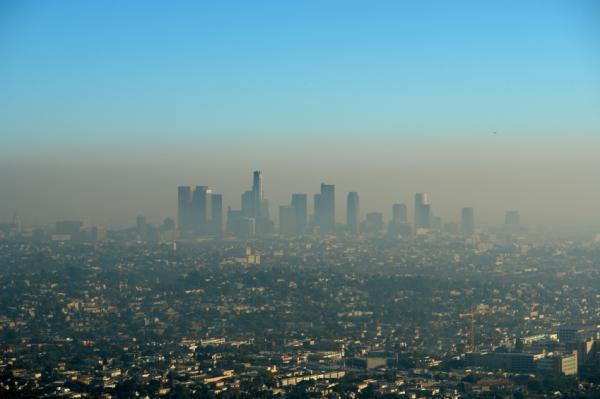
They are the world's cultural capitals, the nerve centers of innovation and the engine rooms of economic growth, but could cities also hold the key to cutting carbon emissions long-term? A 2010 study from the World Bank found that the 50 largest cities and urban areas on the planet are now home to roughly 500 million people and spew out some 2.6 billion tons of greenhouse gasses every year. As urban migration continues apace, these figures are only expected to rise in the short term. While this may initially lead to more pollutants being pumped into the earth's atmosphere, some experts believe it could work out better in the long term. They say that the ecological efficiencies cities can offer, aligned with their financial and political influence, could lead to the development of more effective ways to curb carbon emissions."
Pope Benedict XVI On Climate Change: A Credible Response Is Needed. Here's more from
Vatican Radio: "
Pope Benedict XVI appealed for the success of the climate that are opening tomorrow in Durban, South Africa. Speaking to the faithful gathered in St Peter’s Square for the Sunday Angelus prayer, Pope Benedict expressed the hope that “all members of the international community might reach agreement on a responsible, credible response,” to the phenomenon of climate change, which he described as “complex” and “disturbing”. The Holy Father also asked that leaders’ response be consonant with the spirit and requirements of solidarity, taking into account the needs of the poorest people and future generations. The Holy Father’s appeal came after the traditional prayer of Marian devotion, ahead of which he spoke about the new liturgical season of Advent, which began this weekend with First Sunday Vespers."