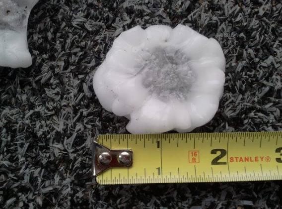
Minnesota Hail
Thanks to the National Weather Service via Susan Buss for the picture below out of Windom, MN from Friday. This is part of the same storm that produced a tornado on Friday near Lakefield and Wilder.
See more HERE:
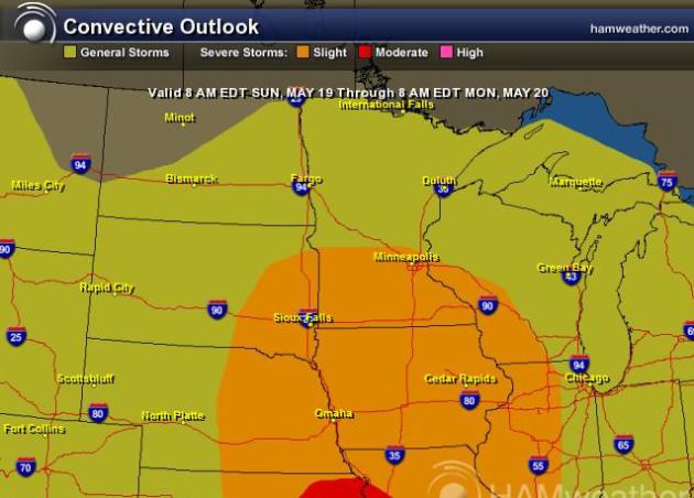
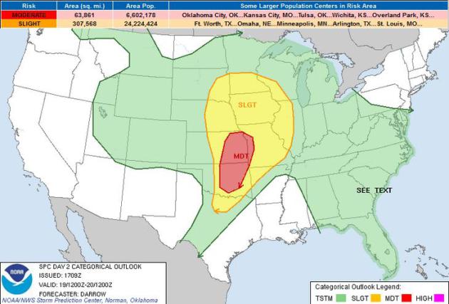
SUNDAY SEVERE?
The Storm Prediction Center has parts of Minnesota under a risk of severe weather for Sunday... Stay tuned for further updates and changes as they become available. Stay tuned to local forecast Sunday afternoon/evening as strong to severe storms may be possible close to home. Keep in mind that the threat area will likely change as the storm moves into the central part of the country...
See the latest severe weather risk from the Storm Prediction Center HERE:
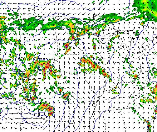
Simulated Radar for Late Sunday Afternoon/Evening
This is a forecast model of
simulated radar for late Sunday afternoon/evening. It appears that
things could get quite active for many areas in the middle part of the
country. Stay tuned for more!
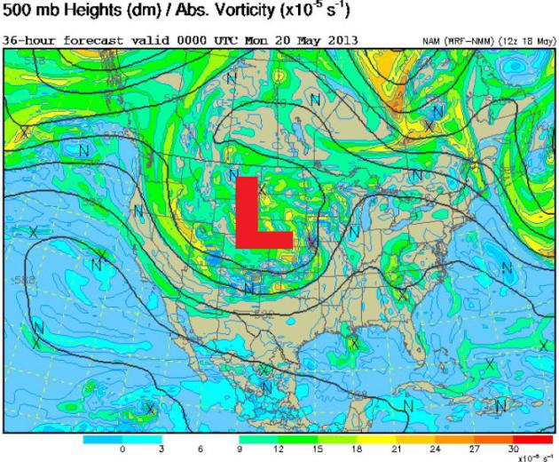
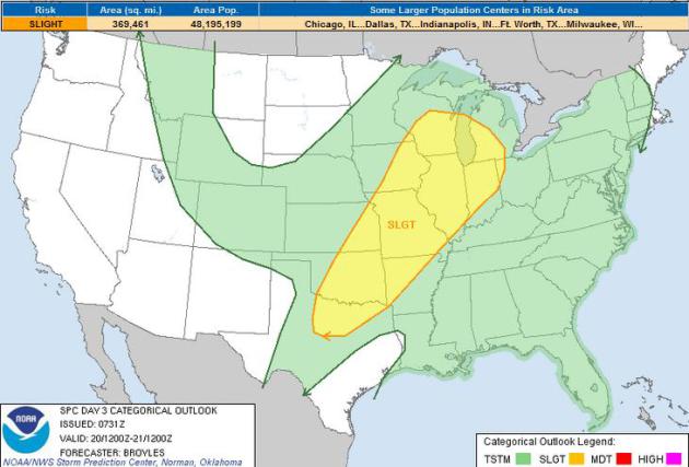
Large Trough Keeps Weather Unsettled
Take a look at the 500mb vorticity map below. This shows 'spin' in the atmosphere. Note the large dip of low pressure over the Central and High Plains. This is wobbling very slowly off to the east and that's why we have such an extended period of shower and thunderstorm activity across the middle part of the country.
The Storm Prediction Center continues severe weather outlooks for Sunday and Monday across the middle part of the country. Note that the ares highlighted below will likely change, but if you're in these areas you'll want to pay attention to local forecasts as strong to severe thunderstorms could be rumling close to home.
SUNDAY THREAT
...REGIONAL SEVERE WEATHER OUTBREAK POSSIBLE ACROSS PARTS OF THE SRN
PLAINS...CNTRL PLAINS AND LOWER MO VALLEY...
...SRN PLAINS TO LOWER MO VALLEY....
LATEST MODEL GUIDANCE CONTINUES TO SUGGEST A SIGNIFICANT MID LEVEL
SPEED MAX WILL EVOLVE WITHIN THE BASE OF THE WRN U.S. TROUGH OVER
THE SRN ROCKIES LATE DAY1...THEN EJECT ACROSS THE SRN PLAINS TOWARD
WRN MO BY 20/00Z. THERE ARE MINOR DIFFERENCES AMONG THE 12Z NAM/GFS
AND 00Z ECMWF...WITH THE NAM FAVORING A BIT MORE AGGRESSIVE SPEED
MAX/HEIGHT FALLS ACROSS NERN OK INTO SWRN MO THAN THE OTHER
GUIDANCE. IT/S NOT ENTIRELY CLEAR IF THE MORE DISPLACED NAM SPEED
MAX IS CORRECT...IF SO THEN SIGNIFICANT SEVERE TSTM ACTIVITY COULD
SPREAD EAST OF DEPICTED MDT RISK.
FOR NOW WILL OPT FOR SOMEWHAT SLOWER GFS SOLUTION AS IT HAS BEEN
VERY CONSISTENT REGARDING THE FORECAST HEIGHT FIELD/WIND SPEEDS
ACROSS THE SRN PLAINS INTO WRN MO. GIVEN THIS SOLUTION...AT SUNRISE
IT APPEARS SYNOPTIC FRONT WILL EXTEND FROM A SFC LOW OVER NCNTRL
NEB...SWD ACROSS CNTRL KS INTO THE TX PANHANDLE. A DRYLINE IS
EXPECTED TO INTERSECT THE COLD FRONT OVER SWRN KS...EXTENDING SSWWD
INTO NWRN TX. EARLY MORNING CONVECTION WILL LIKELY BE CONFINED TO
WARM ADVECTION ZONE ALONG THE NOSE OF THE LLJ ACROSS THE CNTRL
PLAINS INTO THE MID MS VALLEY. SOUTH OF THIS ACTIVITY STRONG WARM
SECTOR BOUNDARY LAYER HEATING IS EXPECTED DURING THE
DAY...ESPECIALLY SOUTH OF I-70 CORRIDOR ACROSS KS/OK/TX.
COMBINATION OF STRONG HEATING AND STRENGTHENING WLY FLOW ALOFT WILL
ALLOW DRYLINE TO MIX TO A POSITION FROM CNTRL KS...SSWWD ACROSS SWRN
OK INTO NWRN TX BY 21Z. IF HOWEVER THE NAM SOLUTION IS CORRECT THEN
THE DRYLINE MAY MIX TO THE I-35 CORRIDOR BY LATE AFTERNOON.
GIVEN THE EXPECTED INTENSE HEATING ALONG THE DRYLINE THERE IS AMPLE
REASON TO BELIEVE DISCRETE SUPERCELL STRUCTURES WILL EVOLVE
INITIALLY NORTH OF THE MID LEVEL JET CORE ACROSS KS...THEN SWD INTO
OK. THIS MAY OCCUR BY 21Z OVER KS AND BY 20/00Z ACROSS OK TO NEAR
THE RED RIVER. FORECAST SHEAR PROFILES STRONGLY FAVOR LONG-LIVED
SUPERCELLS AND WHERE DEW POINTS HOLD IN THE UPPER 60S/LOWER
70S...TORNADOES CAN BE EXPECTED. GIVEN THE EXPECTED
SHEAR/INSTABILITY THERE IS SUPPORT FOR STRONG TORNADOES.
ADDITIONALLY...VERY LARGE HAIL SHOULD ACCOMPANY THIS ACTIVITY.
MATURING COMPLEX OF STORMS SHOULD PROGRESS ACROSS KS/NERN OK INTO
WRN MO WITH MORE SCATTERED ACTIVITY ACROSS CNTRL/SRN OK.
...SERN U.S...
REMNANT MID LEVEL SHORT-WAVE TROUGH WILL SHIFT ACROSS THE SRN
APPALACHIANS SUNDAY. THIS FEATURE MAY ONCE AGAIN SERVE TO FOCUS A
FEW STRONG THUNDERSTORMS BENEATH A WEAKENING MID LEVEL WIND FIELD.
GUSTY WINDS OR PERHAPS SOME HAIL COULD BE NOTED WITH DIURNALLY
DRIVEN CONVECTION.
MONDAY THREAT
...SRN AND CNTRL PLAINS/OZARK PLATEAU...
AN UPPER-LEVEL LOW WILL REMAIN IN PLACE ACROSS THE NRN AND CNTRL
PLAINS ON MONDAY WITH SOUTHWEST FLOW LOCATED FROM THE SRN PLAINS
INTO THE MID MS VALLEY. AT THE SFC...A LOW IS FORECAST TO MOVE NEWD
ACROSS THE SRN PLAINS WITH DEWPOINTS SOUTH AND EAST OF THE LOW IN
THE MID TO UPPER 60S F. A CAPPING INVERSION IN PLACE FOR MUCH OF THE
DAY...SHOULD WEAKEN BY LATE AFTERNOON ALLOWING FOR ROBUST CONVECTIVE
INITIATION. MODEL FORECASTS DEVELOP SEVERAL CLUSTERS OF
THUNDERSTORMS LATE MONDAY AFTERNOON FROM THE SFC LOW NEAR THE RED
RIVER NEWD INTO CNTRL AND ERN OK. THE MODELS APPEAR TO ORGANIZE AN
MCS ACROSS THE SRN PLAINS AND MOVE THIS CONVECTIVE SYSTEM NEWD INTO
THE OZARKS DURING THE EVENING.
FORECAST SOUNDINGS IN SRN OK AND NEAR THE RED RIVER IN NORTH TX AT
00Z/TUE SHOW IMPRESSIVE THERMODYNAMIC AND SHEAR PROFILES WITH MLCAPE
VALUES OF 2500 TO 3500 J/KG AND 0-6 KM SHEAR VALUES OF 45 TO 55 KT.
THIS ENVIRONMENT SHOULD BE FAVORABLE FOR SUPERCELLS WITH LARGE HAIL.
HAILSTONES OF GREATER THAN 2 INCHES IN DIAMETER WILL BE POSSIBLE
WITH THE MORE DOMINANT SUPERCELLS. IN ADDITION...LOW-LEVEL
HODOGRAPHS ALSO LOOK IMPRESSIVE WITH 0-3 KM STORM RELATIVE
HELICITIES IN THE 400 TO 50O M2/S2 RANGE BY EARLY MONDAY EVENING.
THIS SUGGESTS TORNADIC SUPERCELLS WILL BE POSSIBLE WITH A POTENTIAL
FOR STRONG TORNADOES. IF MESOSCALE CONDITIONS COME TOGETHER AS THE
MODELS SUGGEST...THEN A CLUSTER OF TORNADOES COULD OCCUR ACROSS
PARTS OF THE SRN PLAINS LATE MONDAY AFTERNOON INTO THE EVENING. WIND
DAMAGE WILL ALSO BE POSSIBLE WITH SUPERCELLS AND BOWING
LINE-SEGMENTS. THE MAIN CONCERN ABOUT FORECASTING A SIGNIFICANT
EVENT THIS FAR OUT...IS THAT MULTIPLE DAYS OF THUNDERSTORMS BETWEEN
NOW AND MONDAY WILL LIKELY ALTER THE OUTCOME AND THAT THE SCENARIO
WILL BE DIFFERENT THAN WHAT IS CURRENTLY PRESENTED BY THE MODELS.
...MID TO UPPER MS VALLEY/GREAT LAKES...
AN UPPER-LEVEL LOW IS FORECAST TO REMAIN IN PLACE ACROSS THE NRN AND
CNTRL PLAINS ON MONDAY AS A SHORTWAVE TROUGH ROTATES AROUND THE ERN
SIDE OF THE UPPER-LEVEL LOW. THE SHORTWAVE TROUGH AND AN ASSOCIATED
MID-LEVEL JET WILL HELP FOCUS CONVECTIVE DEVELOPMENT ACROSS THE MID
TO UPPER MS VALLEY AND GREAT LAKES REGION MONDAY AFTERNOON. SFC
DEWPOINTS ARE FORECAST TO BE IN THE LOWER TO MID 60S F ACROSS A
BROAD CORRIDOR FROM THE MID MS VALLEY EXTENDING NEWD INTO THE LOWER
OH VALLEY WHERE THE MODELS DEVELOP MODERATE INSTABILITY BY
AFTERNOON. THIS COMBINED WITH MODERATE DEEP LAYER SHEAR
PROFILES...ENHANCED BY THE MID-LEVEL JET...SHOULD SUPPORT SEVERE
THUNDERSTORM DEVELOPMENT. THE SEVERE THREAT SHOULD DEVELOP ACROSS A
BROAD AREA WHERE MESOSCALE FEATURES AND THE MAGNITUDE OF INSTABILITY
WILL BECOME IMPORTANT FOR SEVERE THREAT COVERAGE. WIND DAMAGE AND
LARGE HAIL APPEAR TO BE THE GREATEST THREATS AT THIS TIME BUT MUCH
UNCERTAINTY EXISTS CONCERNING HOW THE EVENT WILL PLAY OUT.
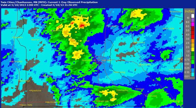
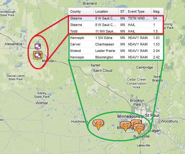
Saturday's Gully Washer
There were several radar
estimates of 1" to 2"+ across parts of central/southern Minnesota from
from Friday and Saturday's thunderstorm activity. Here are few of the
heavier rainfall reports from AM Saturday.
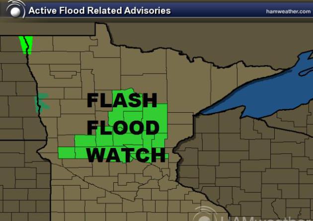
Flash Flood Potential
The National Weather Service has
issued a Flash Flood Watch for parts of central Minnesota due to heavy
rainfall that has already fallen and more heavy rain that may fall thru
Sunday afternoon.
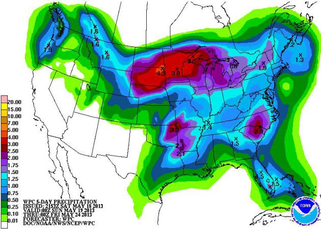
More Heavy Rainfall
NOAA's HPC 5 day rainfall
forecast suggests that there could still be an additional 2" to 4" of
rain across parts of the Upper Midwest by midweek next week. This
certainly could bring about some flooding concerns... stay tuned for
more!
MN Fishing Opener Take 2...
Thanks to my good friends Bob and Kim Jones for sharing this picture. Their daughter Danielle caught this near 28" walleye on Lake Mille Lacs!! Nice catch Danielle!! You may recall last weekend, Lake Mille Lacs was in the news as it was still ice covered and "Ice shoves" or "Ice heaves" were piling up along the south shore up to 25ft. Thanks to 30mph to 40mph winds, ice shoves were responsible for shattering glass patio doors at the Izatys Resort!

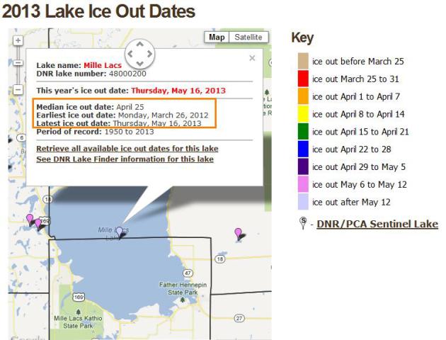
Lake Mille Lacs Officially "Ice Out"
Official "Ice out" dates have been kept for Lake Mille Lacs since 1950. This year, the ice went out on Thursday May 16 and was considered the latest ice out date ever recorded. In contrast, the ice went out on Lake Mille Lacs on March 26th last year and was the earliest ice out date ever recorded... Crazy huh?!? Talk about weather whiplash!
Curious about your favorite lake? See the MN DNR Ice Out Map HERE:
Thanks for checking in, have a great rest of your weekend!
Don't forget to follow me on Twitter @TNelsonWNTV