Our Fleeting Spring
On KARE-11 Julie Nelson called it a "clingy
winter", which sounds right. Like an annoying ex who posts inappropriate
comments on your Facebook page. Depressed? My mom reminded us to
"memorize the bad moments, because it makes the good times even
sweeter."
Weather, like life, is cyclical.
One theory: 2012's record melting of Arctic ice
knocked the jet stream out of alignment, displacing cold air south.
Weather usually tracks west to east, but in recent months we've seen a
sweeping north-south flow. Steering winds have buckled - pulling Gulf
moisture north, erasing drought - while March-like air spills south,
setting the stage for freak blizzards and May snowfall records.
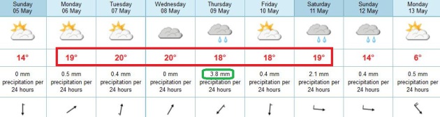
Drier air pushing in from Wisconsin brightens
skies today, with highs near 60F. Moods lighten Monday as highs nudge
70F, in fact lukewarm weather lingers all next week.
Dear diary: we're about to experience a May warm front.
Showers & T-storms sprout Wednesday into
Thursday. Minnesota's Fishing Opener is next weekend; a cooler front
sparks a few showers late Saturday & Sunday.
The ECMWF hints at an airmass cold enough for
flurries one week from tomorrow, further delaying heat, tornadoes, bugs
& humidity.
Insert gasp here.
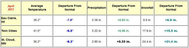
April Numbers. April was more
than 6F colder than average, 2.56" wetter than normal, with nearly 18"
of snow (which is 15.5" snowier than average). More March than April.
More details from the
Twin Cities National Weather Service.
Spring Warning. We're all jaded, cynical and vaguely
disgusted by our "spring" this year. I don't blame you for being
skeptical. But all the models are in agreement: we should see 70 by
Monday and Tuesday; temperatures at or even above average thru the end
of the week, the best chance of a few T-showers late Wednesday into
Thursday, based on ECMWF guidance. A few scattered PM showers are likely
over the weekend as cooler air arrives, a potential cold front early
next week. No, don't pack away the jackets just yet.
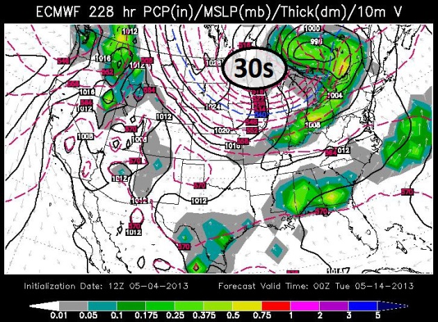
Cold Air Just Doesn't Want To Let Go. The Euro
brings another shot of almost March-like air south of the border a week
from tomorrow; highs stuck in the 40s, maybe some 30s up north with a
freeze? Good grief. Any cold spell will be fleeting with a rapid warming
into the third week of May, but it's remarkable how persistent the
pattern is. ECMWF forecast map valid next Monday evening courtesy of
WSI.
A Volatile Jet Stream. The 250 mb analysis Saturday
evening shows a split flow; a cut-off low temporarily stalled near
Memphis creating a holding pattern over the USA. The northern branch of
the jet stream keeps buckling, plunging Marchlike air south of the
border. We've seen huge north-south sweeps in the steering winds in
recent weeks, pulling unseasonably (unreasonably) cold air south, while
pumping Gulf moisture northward, easing the drought east of the
Mississippi River.
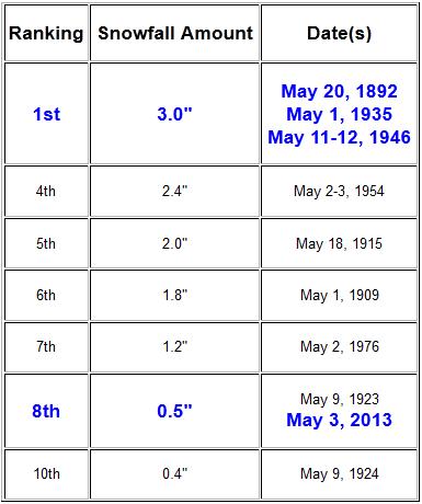
8th Biggest May Snowfall On Record For MSP. The half
inch of slush that fell Friday morning (mainly eastern metro) makes it
the 8th most snow ever reported at KMSP in May. Details from the
Twin Cities National Weather Service: "
On
May 3rd a total of .5" of snowfall was recorded at Minneapolis St. Paul
International Airport. This amount breaks the previous record for the
Twin Cities, which was .2" on May 3rd, 1954. This is also the 8th highest daily snowfall total on record for the month of May in the Twin Cities. To
put this event into perspective, the last time measurable snow was
recorded at Minneapolis St. Paul International Airport during the month
of May was in 1991. In addition, it has been 37 years since a half inch or more of snow has accumulated in May (last occurrence was May 2, 1976)."
Rare May Snowstorm Annihilates Records In Midwest. Here's an excerpt from meteorologist Andrew Freedman at
Climate Central: "...
According to the Minnesota Climate Working Group,
the state daily May snowfall record had stood at 12 inches, which was
most recently set on May 3, 1954. The Working Group said that the
snowstorm was extremely rare for southern parts of the state. “While
May snowfalls are not uncommon in northern Minnesota, heavy May
snowfall in southern Minnesota is rare. A quick scan of all historical
Minnesota May daily snowfall totals greater than or equal to 3 inches
indicates that May 1938 may have been the last time any southern
Minnesota observer reported snowfall totals of similar magnitude,” the
Working Group said on its website..." (photo credit: AP).
"Mother Nature Needs To Be Medicated: An All Or Nothing May".
The extremes are truly breathtaking - records for latest snows on
record from Minnesota to Oklahoma and Arkansas, frost for Texas, while
wildfires rage across California. Here's today's edition of
WeatherNation TV
Climate Matters: "
Head
shaking weather East of the Rockies. Snow reports as far south as
Oklahoma and Arkansas in May? Meantime, to the West, they would be
thrilled to see a little bit of that moisture. Meteorologist Paul
Douglas has more on the history and conditions leading up to today's
meteorological may-hem. If you'd like to check out the Cal Fire wildfire
tips go to http://readyforwildfire.org."
April Climate Summary, Many Records Broken. Here's an excerpt of an excellent, comprehensive recap of our (crazy) April and early May from Dr. Mark Seeley at
WeatherTalk: "
With
the dominance of colder than normal temperatures much of April's
precipitation fell as snow, and it was record setting at many locations.
Isabella (Lake County) reported 25 inches of snowfall on April 19th
breaking the old statewide record of 24 inches (St Cloud in 1893). Many
other observers reported record-setting daily amounts of snowfall on
7th, 11th, 19th, and 23rd. The freqency of snowfall added up to record
monthly snowfall totals for many Minnesota observers, including 55.9
inches at Park Lake (Carlton County), 55.6 inches at Island Lake (St
Louis County), 50.8 inches at Duluth Airport, 47.0 inches at Babbitt,
46.5 inches at Isabella, 45.5 inches at Two Harbors, and 41 inches at
Cloquet. Several other observers reported record monthly totals of
snowfall as well, exceeding 20 and 30 inches in most cases (24.4 inches
at St Cloud for example was a new April record total). Peak snow depth
during the month was over 30 inches in northern parts of the state.
With the thaw at the end of the month maple sap flow was going gang
busters in northern forests and being collected by maple syrup
producers..."
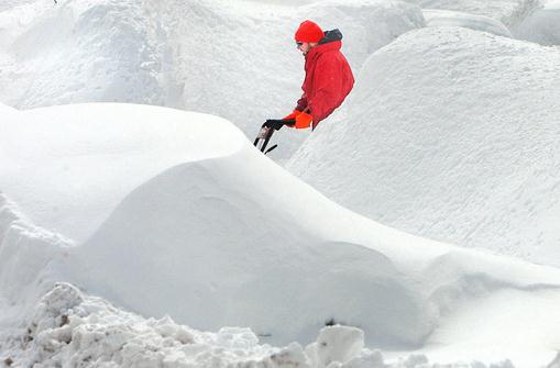
Photo credit above: "
Joel Krochalk, clears his driveway
Friday morning, April 19, 2013 while surrounding by deeply drifted snow
in his and neighboring yards, in Duluth, Minn." (AP Photo/The Duluth News-Tribune, Bob King)
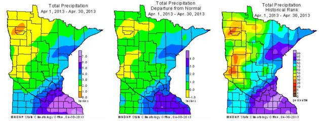
April Highlights - Emerging From Drought. Here's an excerpt of a good summary of April weather conditions statewide, from the
Minnesota DNR:
- April precipitation totals were
well above historical averages in the eastern one-half of Minnesota,
near to below historical averages for the western one-half of the
state. For many southeast Minnesota counties, monthly precipitation
totals topped the long-term average by more than three inches, erasing
drought concerns in those areas. Many observers reported measurable
precipitation on more than 20 days during the month. Some observers
reported precipitation on 10 or 11 consecutive days.
[see: April 2013 Precipitation Map | April 2013 Climate Summary Table]
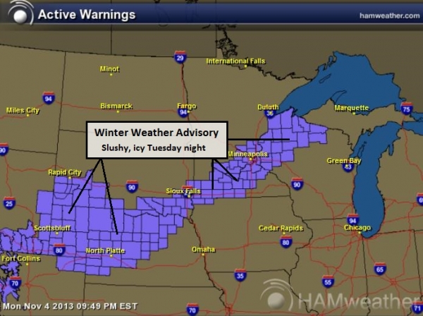
- Ten winter storm warnings and numerous winter weather advisories
were issued for Minnesota counties by the National Weather Service
during the course of the April. Frequent, and often heavy, storms piled
up snowfall totals to record or near-record levels at many locations.
Historical average monthly snowfall totals range from two inches in
southern Minnesota to six inches in northern counties. In many Minnesota
communities, April 2013 monthly snowfall totals exceeded 12 inches.
Numerous locales reported monthly snowfall totals in excess of 24
inches. The focal point for the heaviest of the April snowstorms was
northeast Minnesota, particularly Duluth, where April snowfall reached
historic levels. The monthly snowfall total at Duluth's International
Airport was an astounding 50.8 inches. Not only did this top the
previous April record by nearly 20 inches, it was Duluth's snowiest month ever
for any month of the year. The April snow and cold snarled roads,
delayed agricultural field work, canceled outdoor events, and postponed
natural signs of spring by many weeks.
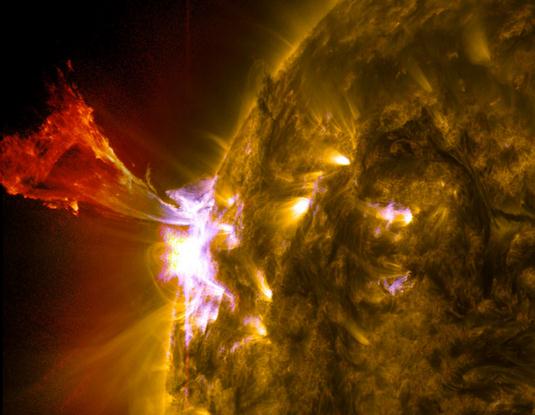
Sun Emits Mid-Level Flare. Here's an update from
NASA on Friday's M-Class flare: "
The
sun emitted a mid-level solar flare, peaking at 1:32 pm EDT on May 3,
2013. Solar flares are powerful bursts of radiation. Harmful radiation
from a flare cannot pass through Earth's atmosphere to physically
affect humans on the ground, however -- when intense enough -- they can
disturb the atmosphere in the layer where GPS and communications
signals travel. This disrupts the radio signals for as long as the
flare is ongoing, and the radio blackout for this flare has already
subsided."
Image credit above: "
A burst of solar material leaps off
the left side of the sun in what’s known as a prominence eruption.
This image combines three images from NASA's Solar Dynamics Observatory
captured on May 3, 2013, at 1:45 pm EDT, just as an M-class solar
flare from the same region was subsiding. The images include light from
the 131-, 171- and 304-angstrom wavelengths.
" Credit: NASA/SDO/AIA.
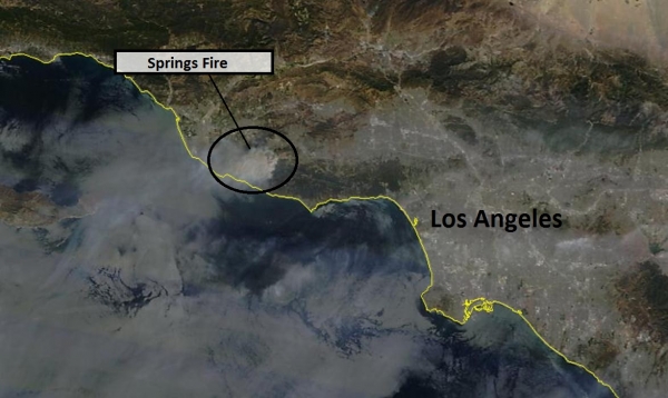
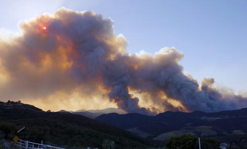
Springs Fire.
The blaze threatening thousands of homes north/west of Malibu is now
30% contained; nearly 2,000 firefighters on the scene. The smoke plume
shows up on high-res NASA satellite imagery.
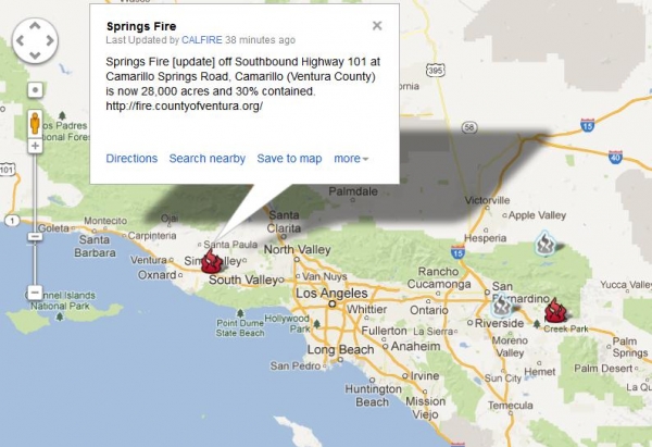
High-Risk Fire Areas.
CAL FIRE
shows the location of the most serious wildfires in southern
California, including the Springs Fire and smaller blazes in the Inland
Empire, between Riverside and Palm Springs.
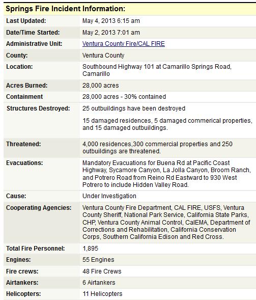
Springs Fire Details.
Mandatory evacuations are still underway, thousands have been
temporarily displaced by the major fire underway in Ventura County.
Portions of the PCH (Pacific Coast Highway) are still closed, the flames
now threatening 220KV transmission lines near the coast.
Details here.
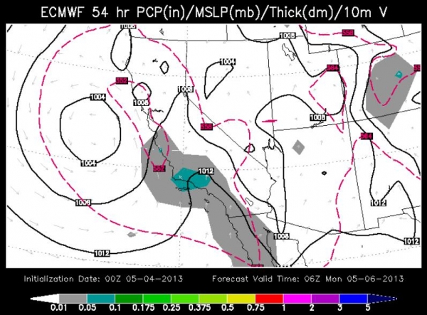
Temporary Relief.
This will be a long, dry, potentially devastating fire season for
California and much of the west (coming after the 4th driest winter
season on record). Major fires in early May are a bad omen, considering
fire season peaks between August and October. But short-term relief is
likely as early as Sunday as humidity levels increase, hot dry Santa Ana
winds shift and flow off the Pacific; light rain likely to give
firefighters the upper hand by late Sunday and Monday.
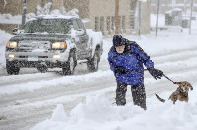
Flash Flood Potential.
The same storm that has been traumatizing much of the central USA (18"
snows in southeastern Minnesota Thursday, a coating of white as far
south at Tulsa and Eureka Springs, Arkansas) is pulling Gulf moisture
north. The storm is "cut-off", temporarily stalled, which will increase
the potential for sustained rains and embedded T-storms capable of
river/stream/urban flooding from Atlanta to Nashville and Chattanooga.
Soaking Rains.
Portions of the southeast may pick up 1 to 1 1/2 month's worth of rain
over the next 72 hours; the greatest potential for flooding problems
from Atlanta to Nashville.
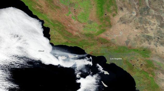
California Wildfires From Space. Here's a post from NOAA's
Environmental Visualization Laboratory: "
A
series of wildfires in Ventura County, California (northwest of Los
Angeles) have burned over 6,500 as of May 3rd, according to the U.S. Forest Service.
The Suomi NPP satellite passed over the blaze on May 2, 2013 around
21:30 Z, capturing this high resolution imagery with its visible and
infrared energy sensors. A stream of smoke is clearly visible moving
west over the ocean, as are the heat signatures from the active fires
areas. The fires are expected to be contained by May 4th, and fire
weather conditions in the region seem to be improving, according to the
NOAA Storm Prediction Center."
Dry Winter, Warming Trend Foretell Fire Danger. West
of the Rockies it was a Top 5 driest winter season on record - the fact
that we're tracking major blazes in early May is a bad omen. It will be
a long, hot, dry and fiery season for the west in 2013. Here's an
excerpt from
thehour.com: "...
We're
looking at a combination of a low-moisture winter and a warming and
drying pattern in the West that will increase the fire potential," said
Ed Delgado, predictive services manager.
If that sounds familiar to the region's residents, it should. In 2012,
record-setting fires raged in New Mexico and Oregon, while destructive
Colorado blazes torched hundreds of homes amid one of the state's worst
seasons in years. Just like last year, Colorado experienced some of its
first 2013 wildfires in March...."
Photo credit above: "
Smoke billows from a fire burring in
Point Mugu State Park during a wildfire that burned several thousand
acres, Thursday, May 2, 2013, in Ventura County, Calif." (AP Photo/Mark J. Terrill)
Are You Ready For Wildfires? CAL FIRE has a
great interactive tool with information for homeowners to help them lower the risk of wildfire damage and destruction.
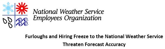
Furloughs And Hiring Freeze To The National Weather Service Threaten Forecast Accuracy.
The first time lives are put at risk by these planned furloughts there
will be a public outcry. Wait for it. Here's an excerpt of a press
release from
The National Weather Service Employees Organization: "
National
Weather Service employees say that four furlough days added to the
current hiring freeze stretches already short-staffed offices to a
breaking point, puts thhe American public at risk, and jeopardizes the
agency's mission of saving lives and property. Most of the NWS employees
being furloughed are designated "emergency essential", because of their
public safety responsibilities and are required to work, even during
catastrophic conditions. Commerce, air travel, and most daily events
hinge on accurate forecasts. The forecasts become life savers in the
summer when floods, tornadoes, hurricanes, heat waves, wildfires and
thunderstorms are most prevalent. "Furloughts to the National Weather
Service, in conjunction with the furloughs to the other agencies the
nation depends on for emergency services, is like playing chicken with
the American public," said NWSEO President Dan Sobien. "One missed event
would realistically cost millions. NOAA is risking everything and has
nothing to gain. It's not a sound decision...."
Fracking Won't Get The U.S. Out Of The Persian Gulf. Here's an except of an interesting perspective on "energy independence" from Steve LeVine at
Quartz:
"...The US seems likely to produce a lot more oil, perhaps even a
volume nearing or meeting self-sufficiency, Levi says. If so, it will
be thanks to a boom in volumes from two sources—the deepwater Gulf of
Mexico,
and shale
in places like North Dakota. But an age of plenty will trigger
corresponding steps by other nations to neutralize perceived adverse
impacts on themselves. Geopolitically–in terms of the financial burden
of patrolling the world’s sea lanes, for instance—Americans are likely
to be right back where they started, meaning footing the bill for a
global Navy. The Pacific is the same—the US is highly unlikely to pull
back from its robust security presence despite China’s wish that it
stop...."
Photo credit above: "
Never done." AP Photo/Hassan Ammar.
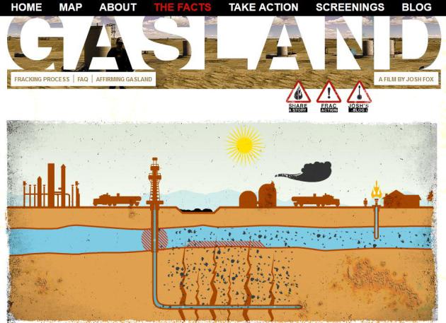
So You Think "Fracking" Is Safe? Watch This Movie.
I've been trying to keep an open mind about hydraulic fracturing, or
"fracking", pumping huge amounts of water, and nearly 600 chemicals,
deep into the ground to release natural gas from rocks and sediment. The
idea of "energy independence" resonates, especially with a son in the
Navy. But after watching "
Gasland"
I'm not so sure, in fact I'm suddenly grateful there's no natural gas
or oil underneath Minnesota. I realize North Dakota is undergoing an
economic boom, and good for them. But if drinking water becomes
contaminated, streams fouled, health of nearby residents negatively
impacted, at what cost are we chasing the pipedream of energy
independence. Better yet, put up a few solar panels and a wind turbine.
Not sure if it's on Netflix yet (I watched via DirecTV), but this is one
documentary you should put on your to-do list.
No, Google Glass Is Not A Segway For Your Face. My favorite headline of the week; here's an excerpt from
pandodaily.com: “
Google Glass is so futuristic it’s like wearing a Segway on your face.”–
Tweet by Matt Novak
"
That Tweet likely articulates Google’s biggest fear for Glass,
its wearable computer. What if the cool crowd doesn’t accept it? What
if, like the Segway, it becomes an emblem of the awkwardly nerdy? What
if consumers reject the technology because, even though it’s amazing,
there’s too much social stigma to being seen in public with it?..."
History Of The High-Five. I did not know that -
think of the fun you'll have with friends at your next sporting event.
Here's an excerpt of a fascinating article at
ESPN: "
WHEN I FIRST PHONED
Lamont Sleets this spring, I knew only the following: He is a
middle-aged man living in the small town of Eminence, Ky.; he played
college basketball for Murray State University between 1979 and 1984;
and he reportedly created one of the most contagious, transcendently
ecstatic gestures in sports -- and maybe, for that matter, American
life. I was calling Sleets because I wanted to talk to the man who
invented the high five. I'd first read about him in 2007 in a press
release from National High Five Day, a group that was trying to
establish a holiday for convivial palm-slapping on the third Thursday
in April. Apparently, Sleets had been reluctantly put in touch with the
holiday's founders, and he explained that his father, Lamont Sleets
Sr., served in Vietnam in the 1st Battalion, 5th Infantry -- a unit
nicknamed The Five..."
Image credit above: Illustrations by Bruce Hutchison for ESPN The Magazine. "
The origin of the high five is as mysterious as it is timeless."
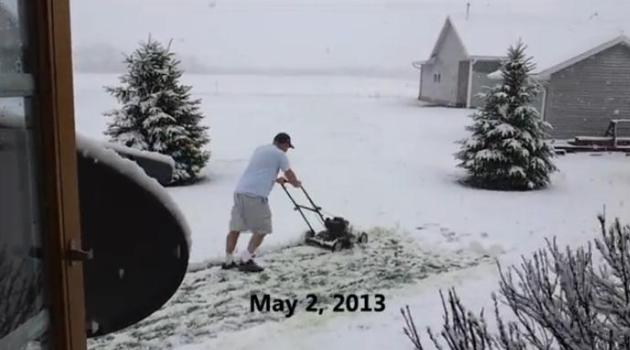
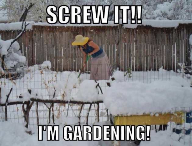
I'm Mowing The Damn Lawn! This
YouTube clip provided a badly-needed chuckle yesterday. Details from
kcci.com: "
A Story County man was not about to let a little May snow keep him from his yard work. Roger Fritz shared this video on YouTube.
He put on shorts and T-shirt for the effort. Fritz said, "It was May 2,
and I decided the grass needed cut." Share your fun snow photos and
video through u local."
Climate Stories...
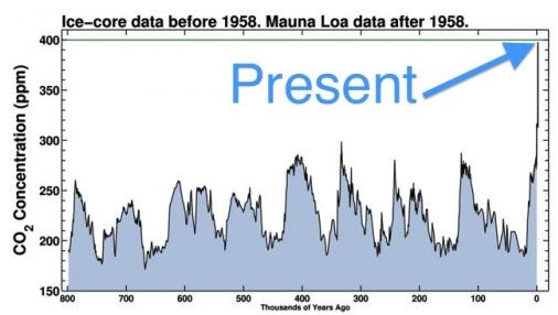
The Last Time CO2 Was This High Humans Didn't Exist.
Climate Central has the story; here's an excerpt: "
The
last time there was this much carbon dioxide (CO2) in the Earth's
atmosphere, modern humans didn't exist. Megatoothed sharks prowled the
oceans, the world's seas were up to 100 feet higher than they are today,
and the global average surface temperature was up to 11°F warmer than
it is now. As we near the record for the highest CO2 concentration in
human history — 400 parts per million — climate scientists worry about
where we were then, and where we're rapidly headed now. According to
data gathered at the Mauna Loa Observatory in Hawaii, the 400 ppm mark
may briefly be exceeded this month, when CO2 typically hits a seasonal
peak in the Northern Hemisphere, although it is more likely to take a
couple more years until it stays above that threshold, according to
Ralph Keeling, a researcher at the Scripps Institute of Oceanography..."
Graphic credit above: "
CO2 levels are far higher now than they have been for anything during the past 800,000 years." Scripps Institution of Oceanography.
NASA Study Projects Warming-Driven Changes In Global Rainfall. Here's an excerpt from a
NASA press release: "
A
NASA-led modeling study provides new evidence that global warming may
increase the risk for extreme rainfall and drought. The study shows for
the first time how rising carbon dioxide concentrations could affect
the entire range of rainfall types on Earth. Analysis of computer
simulations from 14 climate models indicates wet regions of the world,
such as the equatorial Pacific Ocean and Asian monsoon regions, will
see increases in heavy precipitation because of warming resulting from
projected increases in carbon dioxide levels. Arid land areas outside
the tropics and many regions with moderate rainfall could become drier.
The analysis provides a new assessment of global warming's impacts on
precipitation patterns around the world. The study was accepted for
publication in the American Geophysical Union journal Geophysical
Research Letters..."
Carbon Tax Is Best Way To Minimize Disastrous Climate Change: Opinion. Here's an excerpt of an Op-Ed from a Senior Engineer at JPL, The Jet Propulsion Laboratory, at the
Los Angeles Daily News: "...
This
is indeed the situation on Earth today. Earth's climate is changing
rapidly and there is grave concern about the potentially adverse
effects of these changes for life on the planet. Fossil fuels have
brought us breath-taking prosperity, but over the long term this wealth
is illusory because full-cost accounting hasn't been practiced "" for
example the high cost on the biosphere of burning coal, oil and gas.
Most of us are cost-conscious in making decisions, yet these
business-as-usual "cheap" energy sources will contribute to multiple
extinctions in the near future, leaving our children with only limited
and very expensive options. The problem is not so much today's climate.
As noticeable and frightening as the changes are to date, they're just
the tip of the iceberg and can be accommodated, barely. The alarming,
existential threat is the continuance of business-as-usual leading to
unprecedented heating. We have to be smart enough to anticipate this
heating trajectory and take steps to avoid it..." (Photo: Reuters).
"...
Last year was the 27th consecutive year with an above average
global temperature and the ninth warmest year on record. The years
between 2001 and 2012 were among the top 13 warmest on record." -
The Telegraph
Climate Change Creates Maddening Weather Whiplash. Yep, that pretty much sums it up - from one extreme to the next. Here's an excerpt of a story from Discovery News and
NBC News: "...
The
term "weather whiplash" was first invoked to describe this effect by
science writer Andrew Freedman in 2009. But now climate scientists are
using the term, and pointing to the current floods, in the Midwest as
the classic case. "I'm using it now to describe the longer term kind of
flooding-drying cycles," said meteorologist Jeff Masters, co-founder
and director meteorology at the Weather Underground. "It's pretty
amazing. It used to be only one in three years were flood years. Now
it's almost every year." The whiplash has become especially painful in
river towns where just a few months ago dredging was needed to keep
goods afloat and keep communities alive. Now sandbags are the only
thing holding back the rivers from flooding the very same towns..."
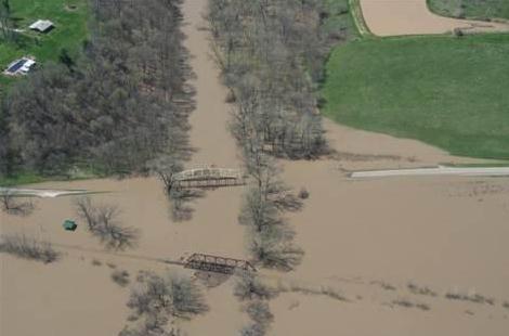
Photo credit: Office of Missouri Gov. Jay Nixon via Reuters. "
Flooding
is seen along the Mississippi River near LaGrange, Missouri, in this
April 21, handout photo courtesy of the Missouri Governor's Office."
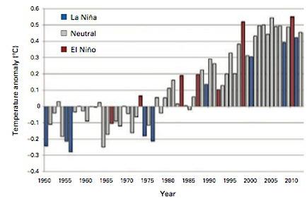
Record Low In Arctic Sea Ice Caused By Global Warming, UN Says. Here's an excerpt from an update at
The Telegraph: ...“
Despite
the cooling influence of à La Niña episode early in the year, 2012
joined the 10 previous years as one of the warmest – at ninth place – on
record," he said. "Although the rate of warming varies from year
to year due to natural variability caused by the El Niño/La Niña cycle,
volcanic eruptions and other phenomena, the sustained warming of the
lower atmosphere is a worrisome sign. “The continued upward trend in
atmospheric concentrations of greenhouse gases and the consequent
increase in radiative forcing of the Earth’s atmosphere confirm that
the warming will continue...”
Graphic credit above: "
January–December global land and ocean surface temperature anomalies (relative to 1961–1990) for the period 1950–2012."
U.N. Report Highlights Disturbing Signs Of Climate Change. Following up on the story above, here's another perspective on the U.N. report from
redOrbit.com: "
The
United Nations’ official weather agency, the World Meteorological
Organization, has announced that last year saw record-low levels of
Arctic sea ice – yet another troubling sign of changing global climate
patterns. The WMO also found that 2012 was the ninth-warmest year since
official records started in the 1850s, according to a report
released by the organization on Thursday. It also stated that every
year from 2001 to 2012 was among the top 13 warmest on record, with the
hottest being 2010. WMO Secretary General Michel Jarraud called the findings a “disturbing sign of climate change...”
Photo credit:
Photos.com.