Happy Mosquitoes
The person who said "there's no such thing as
bad weather - just poor clothing choices" obviously hasn't spent any
time in Minnesota this year. I think I've enjoyed a grand total of two
Adirondack-chair-worthy evenings since ice went off the lake. Yes, the
drought is easing, everything is lush & green, but the stubborn cool
& gray has many of us in a dark March-like funk.
Planalytics says the Memorial Day weekend was
the coolest since 2005, nationwide. No wonder we feel cheated: Memorial
Day 2012 was the warmest in 50 years.
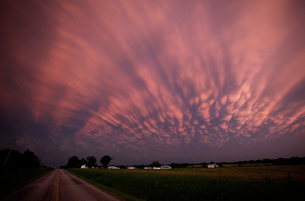
It feels like Mother Nature is driving under the influence, swerving from one crazy extreme to the next.
Warm fronts seem to tire before reaching our
latitude, but a slow-motion boundary finally breaks through with 70s;
high dew points & instability fueling severe storms later today,
again Thursday. It's going to be a tough month for severe storms - just a
hunch.
We dry out Friday, cool off Saturday with a few
showers up north. Sunday may restore your faith in spring, before the
next round of heavy storms arrives next Tuesday. As long as the front
separating cool from hot loiters nearby it's going to be tough to break
out into sustained 80s & 90s.
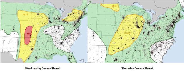
Severe Threat. The more sun we see today the more
unstable the atmosphere, the greater the potential for strong to severe
T-storms by late afternoon and evening. A moderate risk from SPC over
the Central Plains means a risk of larger, more violent EF-2+ tornadoes
from near Oklahoma City to Wichita and Lincoln.
A Stormy 48 Hours. The approach of a slow-moving
cool front, coupled with moisture streaming out of the Gulf of Mexico,
will set the stage for scattered T-storms, some severe, today, again
Thursday. The threat of heavy weather drops off Friday as winds turn
around to the southwest, then west, pulling drier, cooler air into
Minnesota by late week.
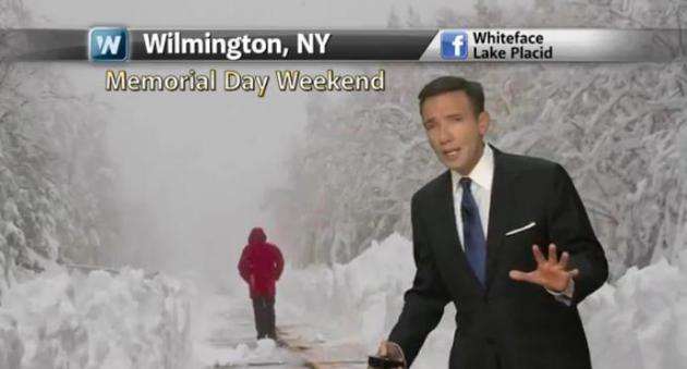
More Extreme Rains (And Snows). Nearly 3 feet of
snow in upstate New York, while residents of San Antonio clean up from a
1 in 100+ year flood? Here's the latest installment of
Climate Matters, courtesy of WeatherNation TV: "Meteorologist Paul Douglas says "
It's
like mother nature is driving under the influence, swerving down the
highway veering from one side of the road to the next". The central
part of the country experienced flooding in 2011, followed by a major
drought in 2012 and now back to flooding again."
*
Flood Disaster Emergency declared for 13 Iowa counties. Details
here.
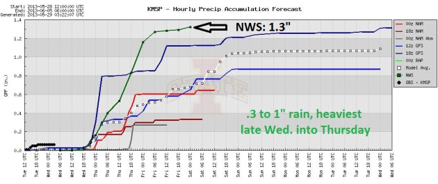
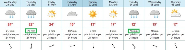
Shocker: Wet And Stormy Into Next Week. We'll get a
few sunny breaks, but probably not as much blue sky as you want (or
need) right about now. Thursday appears to be the wettest day of the
week; a weekend cooling trend (best chance of an instability shower up
north). Sunday appears to be the cooler, sunnier, drier day of the
weekend right now. More heavy showers and T-storms rumble in by Tuesday
of next week. Not a heat spike in sight. ECMWF forecast highs in
Celsius, btw.
A Volatile Pattern. The NAM
model shows showers and T-storms pushing eastward across the Plains and
Midwest, reaching the Ohio Valley by Friday. Cooler weather pushes into
the Upper Midwest by the end of the week. Summer is still on indefinite
hold across much of the USA.
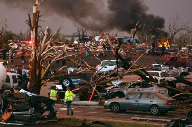
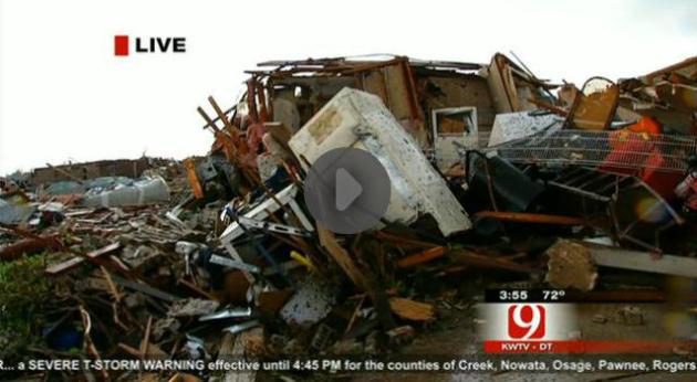
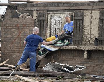
When Disaster Strikes America, A More Skilled Response. Here's a segment of a story at
Yahoo News: "...
Improved forecasts are helping to limit the loss of life, and the fallout from hurricane Katrina
has dramatically reshaped disaster response. Federal, state, and
private officials, who once had only a vague notion of what their
counterparts were doing, now coordinate to the point that folks on the
ground know who will be collecting lost pets and who will be flipping
burgers for the droves of emergency workers. To be sure, the Moore
tornado was not of the scale of Katrina or superstorm Sandy.
But the story of how ATV-riding urban search-and-rescue teams here
were on their second and third rounds of searches less than 24 hours
after the tornado touched down suggests how much has changed since New
Orleans was lawless and underwater for days in late summer of 2005..."
Storm Chasers Undaunted After Deadly Oklahoma Tornado.
Do chasers serve a purpose and collect essential information, photos
and video? Absolutely. Do them sometimes get in the way? Absolutely.
Here's an excerpt from
denverpost.com: "...
Storm
chasing was once a relatively rare activity, conducted primarily by
meteorologists who tried to get close enough to a tornado for research
that could help predict the path of future tornadoes. Now there are so
many people running into a tornado's wake so they can capture up-close
videos that there are traffic jams of storm-chasing vehicles on
otherwise lonely country roads. This tornado does not appear to have
shaken the resolve of serious storm chasers, many of whom have moved
here to be closer to tornado territory. "I wish it would," said Howard
Bluestein, a meteorology professor at the University of Oklahoma, which
tries to walk a fine line by neither encouraging nor discouraging
storm chasing. "It's becoming difficult to go out in the middle of the
countryside with your mobile Doppler radar and you get stuck in traffic."
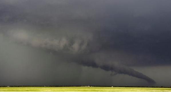
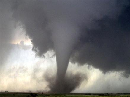
Photo credit above: "
The
funnel of a tornado touches the ground near South Haven, Kan., last
week. It was part of a massive storm front that swept north through the
central U.S." (Gene Blevins, Reuters).
What Makes Oklahoma A Perfect Place For Tornadoes? WeatherBug has the story; here's a clip: "...The
exact location where tornadoes hit is random, but the fact that they
occur so frequently in Oklahoma does have a reason. Brooks said there is
no other place in the world that has the same geographic setup that
Oklahoma does. The warm, humid air that comes from the Gulf of Mexico
interacts with the cool, dry air coming from the Rocky Mountains.
Southerly winds at the surface interact with strong westerly winds in
the upper atmosphere and all combine to create "the laboratory to make
tornadoes." "It`s the only place on the planet that has a nice, warm
body of water to the south and a high, wide range of mountains to the
west," Brooks said..."
Behind The Scenes At Tornado's Ground Zero. Here is a story focused on how one local TV news crew covered the carnage of Moore, Oklahoma last week; an excerpt from
tvnewscheck.com: "...
Torp
says the already dire situation — unusable roads, downed wires and
smashed cars — was compounded by the fact that rescue workers had a
hard time getting to the damaged section of Westmoor. Once they did,
they had even more difficulties because key markers like street signs
were gone. "Even people who lived in the neighborhood for years, had a
hard time figuring out where their house was after the tornado,” Torp
says. “This added to the challenge of trying to find those missing....”
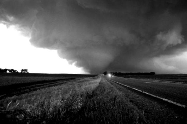
The Past And Future Of Tornado Prediction. Up until
the early 1950s it was illegal to use the T-word, to even utter the word
"tornado", for fear of causing public panic. Yes, we've come a long
way.
Popular Mechanics has the story; here's an excerpt: "...
Today,
the average warning time is more like 15 minutes, and the weather
service uses a combination of weather balloons—launched every 12
hours—satellite, radar, and weather-station feeds to make those
predictions. Today forecasters look at long-range temperature data and
wind-flow patterns that can produce atmospheric instability (warm air at
the surface, cold air higher up), moisture, and wind shear (change of
wind speed at different levels of elevation). Those latter ingredients
are the building blocks of tornadoes. While most of the news stories in
the wake of Monday’s tornadoes have reported the fact that there was a
warning issued 16 minutes before the tornado touched down near Moore,
the Storm Prediction Center was hard at work, warning local
forecasters, the media, and local citizens long before that..." (2010 Albert Lea tornado pic courtesy of WeatherNation TV meteorologist Aaron Shaffer).
Can We Get Better At Predicting Tornadoes? The
answer is yes, but improvements will be incremental over time, and
probably not dramatic. Here's a clip from a story at CBS News and
ktvq.com: "...
Forecasters
have managed to increase the average lead-time for a tornado warning
from 5 minutes in the 1980s to about 13 minutes today. (The lead-time
is actually closer to 18 minutes when officials put out a warning - but
they only manage to do so about 80 percent of the time.) "This is the
hardest forecasting problem of all," said Cliff Mass, an atmospheric
sciences professor at the University of Washington. He believes that it
is possible to increase the advance time for a tornado warning to as
much as three hours, though he doesn't know if meteorologists can do
better than that. "I think six hours or eight hours is going to be very
hard," he said..."
A Tornado's Heading Your Way. Now What? Local TV
meteorologists in Oklahoma City warned residents of Moore without
basements or underground shelters to drive away, that this tornado might
be "unsurvivable" - advice you don't hear very often. Here's an excerpt
of a story from CNN and
kmsstv.com: ..."
If
you have good information on the storm, if you have plenty of warning,
if you have an automobile, it may make sense (to drive away), but I
personally don't feel that's the advice that we want to give the
public." A better answer, he said, would be to plan. "I think there is
today a storm shelter or solution for just about every situation, so I
would urge people to consider procuring a storm shelter for their
home." The options for shelters are many: above-ground, below-ground,
mounted in the garage, on the patio, on a poured slab or even in a space
carved out beneath the slab..." (photo credit: MGN Online).
Budget Cuts Will Hinder Our Ability To Predict Severe Weather.
The dreaded "sequester" may be showing up at a local National Weather
Service office near you; here's an excerpt from LiveScience and
Business Insider: "
The
tornado that hit Moore, Okla., on Monday (May 23) killed an estimated
two dozen people and caused devastating property damage. Residents had
advance warning of the storm, thanks to weather forecasts. But with
forced budget cuts in effect, forecasters may not be adequately
prepared for future natural disasters. In March, $85 billion in across-the-board spending cuts,
known as the sequester, took effect. The cuts slashed 8.2 percent from
the 2013 operating budgets of most federal agencies. The National
Oceanic and Atmospheric Administration (NOAA) suffered a 7 percent
reduction in its fiscal year 2013 budget as a result of sequestration.
Thinned-out staffs and under-maintained equipment could hinder the
agency's ability to give timely and accurate weather forecasts, experts
say..."
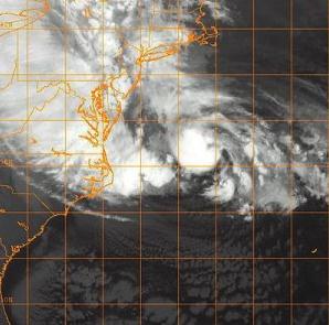
U.S. Hurricane Forecasts Could Be Better. Track forecasts are usually fairly good, but intensity predictions are very difficult. Here's an excerpt from a story at
Scientific American: "...
Perhaps
the NWS itself knows it can improve hurricane forecasts. Last week it
announced it would use $25 million recently appropriated by Congress to
upgrade some of it supercomputers.
U.S. hurricane models have a resolution of 25 kilometers, yet the
European model has a resolution of 16 kilometers. Tighter resolution
could allow forecasters to better assess how a hurricane is growing and
moving, given that the inner core of such a storm is often in the range
of 80 kilometers across. Predicting how high a coastal hurricane’s
storm surge might be—often the cause of the greatest damage—is even
harder than predicting its path, however, and might require different
advances. Technology alone is not the answer, however. “A new computer
is really good, but you also need the people to use it,” says Chris
Davis, a senior scientist at the National Center for Atmospheric
Research (NCAR) in Boulder, Colo. “It takes a lot of work to use that
better resolution well.” Researchers must properly recalibrate models
to exploit the new resolution, and must learn how to interpret the
results..."
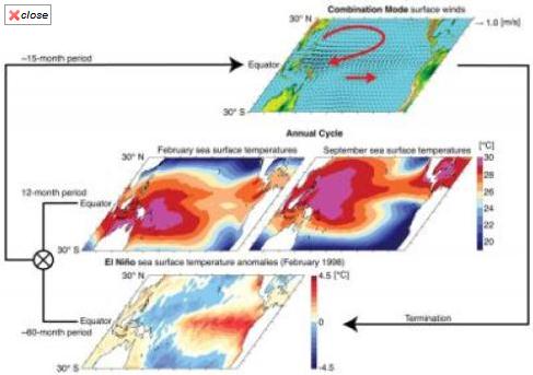
Climate Researchers Discover New Rhythm For El Nino.
La Nina has faded into an "ENSO-neutral" situation, neither El Nino
warming or La Nina cooling; there are some signs we might be heading
into a weak El Nino by next winter, but nothing definitive yet. Here's
an excerpt from
Science Daily: "...
A
mystery, however, has remained despite decades of research: Why does
El Niño always peak around Christmas and end quickly by February to
April? Now there is an answer: An unusual wind pattern that straddles
the equatorial Pacific during strong El Niño events and swings back and
forth with a period of 15 months explains El Niño's close ties to the
annual cycle. This finding is reported in the May 26, 2013, online
issue of Nature Geoscience by scientists from the University of Hawai'i
at Manoa Meteorology Department and International Pacific Research
Center. "This atmospheric pattern peaks in February and triggers some of
the well-known El Niño impacts, such as droughts in the Philippines
and across Micronesia and heavy rainfall over French Polynesia," says
lead author Malte Stuecker..."
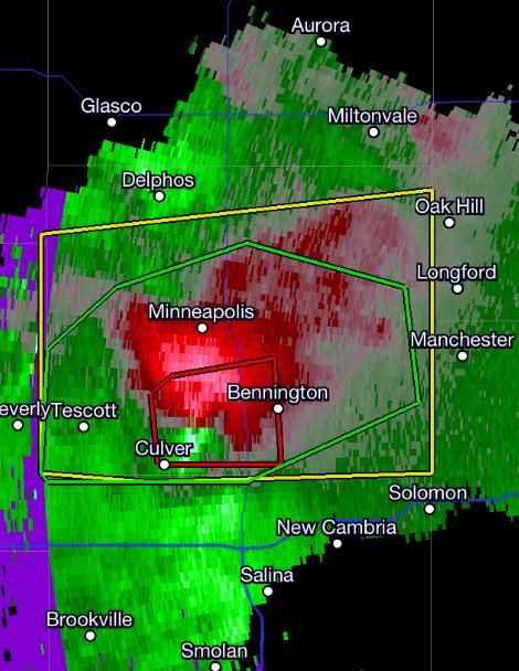
What Kind Of Warning Are We In Again? WeatherNation TV meteorologist Todd Nelson writes: "
Can't
say I've ever seen this before... A stationary thunderstorm with
significant rotation surrounded by a flood warning and severe
thunderstorm warning! Wow!!"
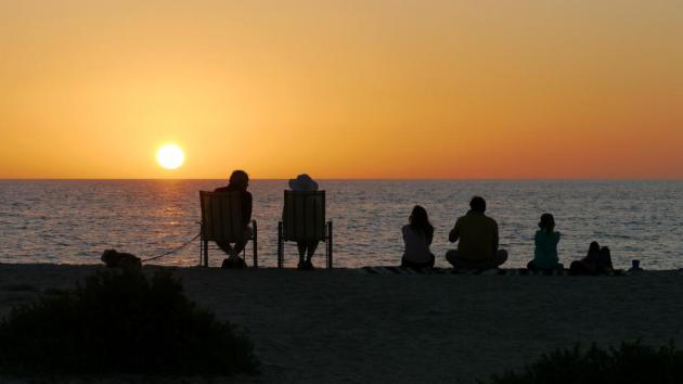
How Happiness Changes With Age. Here's an excerpt of an article at
The Atlantic that resonated with me: "...
Happiness
becomes less the high-energy, totally-psyched experience of a teenager
partying while his parents are out of town, and more the peaceful,
relaxing experience of an overworked mom who's been dreaming of that
hot bath all day. The latter isn't less "happy" than the former -- it's
a different way of understanding what happiness is. Social
psychologists describe this change as a consequence of a gradual
shifting from promotion motivation -- seeing our goals in terms of what
we can gain, or how we can end up better off, to prevention motivation
-- seeing our goals in terms of avoiding loss and keeping things
running smoothly. Everyone, of course, has both motivations. But the
relative amounts of each differ from person to person, and can shift
with experience as we age..."
Climate Stories....
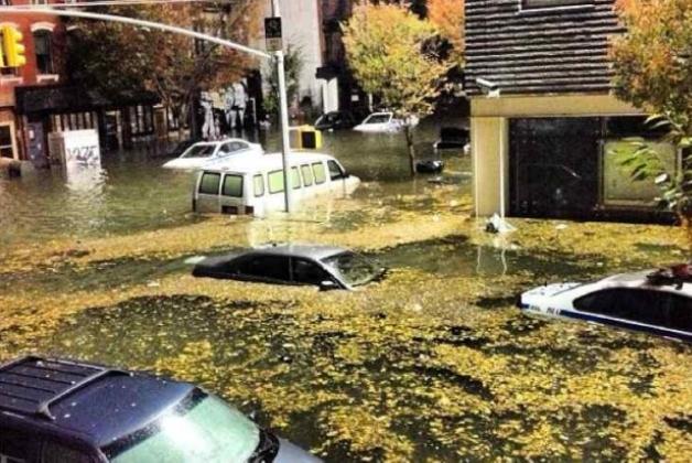
Sandy-Like Floods Could Hit New York Every 2 Years By 2100.
The reason: rises in sea level, taking place faster than computer
models are predicting. Here's an excerpt of a Scientific American story
appearing at
Salon: "
By 2100 devastating flooding of the sort that Superstorm Sandy unleashed
on New York City could happen every two years all along the valuable
and densely populated U.S. east coast—anywhere from Boston to Miami. And
unless extreme protection measures are implemented, people could again
die. Hyperbole? Hardly. Even though Sandy’s storm surge was
exceptionally high, if sea level rises as much as scientists agree is
likely, even routine storms could cause similar destruction. Old,
conservative estimates put the increase at two feet (0.6 meter) higher
than the 2000 level by 2100. That number did not include any increase
in ice melting from Greenland or Antarctica—yet in December new data
showed that temperatures in Antarctica are rising three times faster
than the rate used in the conservative models. Accelerated melting has
also been reported in Greenland. Under what scientists call the rapid
ice-melt scenario, global sea level would rise four feet (1.2 meters by
the 2080s, according toKlaus Jacob,
a research scientist at Columbia University’s Lamont–Doherty Earth
Observatory. In New York City by 2100 “it will be five feet, plus or
minus one foot,” Jacob says..."
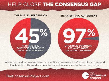
97% Global Warming Consensus Meets Resistance From Scientific Denialism.
The Guardian has the story; here's an excerpt: "
The Skeptical Science survey finding 97% expert consensus on human-caused global warming has drawn an incredible amount of media attention. Hundreds of media stories
documented our survey and results. Lead author John Cook and I
participated in a number of interviews to discuss the paper, including
on Al Jazeera, CNN, and ABC. President Obama even Tweeted about our results to his 31 million followers.
The story has been so popular mainly because our results present a
simple but critical message. There is a wide gap between the public
awareness and the reality of the expert consensus on human-caused
global warming...
A 2009 paper published in the European Journal of Public Health by Pascal Diethelm and Martin McKee discussed five characteristics common to scientific denialism:
1) Cherry picking;
2) Fake experts;
3) Misrepresentation and logical fallacies.
4) Impossible expectations of what research can deliver; and
5) Conspiracy theories;.."
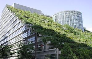
Energy Efficiency Can Make Billions While Fighting Climate Change. Make it a win-win, clean up the atmosphere, reduce your carbon footprint AND save money at the same time. Here's a clip from
Triple Pundit: "
Energy
efficiency could be a several hundred billion dollar investment
opportunity in the United States, but better policies are required to
unlock broad-based financing from institutional investors, according to
a new study by investor advocacy group Ceres. Power Factor: Institutional Investors’ Policy Priorities Can Bring Energy Efficiency to Scale details
the results of a survey of nearly 30 institutional investors and other
experts from the energy, policy and financial sectors that identified
three areas of policy: utility regulation, demand-generating policies
and innovative financing policies. The study finds that these three
areas have the potential to take energy efficiency financing to a scale
sufficient enough to attract significant institutional investment...."
Photo credit above: "
The International Energy Agency
estimates that one-third of emissions reductions must come from energy
efficiency in order to avoid the worst impacts of climate change."